
27 April 2011
Dramatic new landslide and rockfall videos
In the last few days a series of new videos have emerged of landslides and rockfalls as they occur. Thanks to various people for highlighting them to me. I am still struggling with the WordPress embed function (it was so easy in Blogger!), so apologies that some of this will have to be done through external links.
First, a couple of weeks ago a debris flow killed 20 people when a small bus was carried into a ravine near to the city of Manizales in Colombia. In the last 24 hours a video has emerged on Liveleak that reportedly shows the landslide further up the slope. It is not clear to me that this is the same event, but the footage is certainly dramatic, not least because it is clear that it was unexpected. The video is available here. One interesting aspect is the clear illustration of the dangers of being inside a building when such an event occurs – witness the way that the slide passes through the building and then out of the windows.
Second, and on a very different scale, Garry Hayes of the excellent Geotripper blog caught on camera a small but technically interesting rockfall event near to Yosemite last week, which can be viewed at this link. Helpfully there are several photographs of the site too, taken both before and after the slip.
Thirdly, thanks to Lisa Denke for bringing this remarkable video of a rockslide in Wyoming to my attention. This one should embed, but if not it can be viewed here, and there is a commentary here. You may want to turn the sound down before you play it though!
The person who captured the video had a very lucky escape – there is not much doubt that being struck by that debris would not have been survivable. However, look carefully at what happened before the main slide event. There is extensive precursory rockfall activity on both margins of the landslide, which I would suspect occurred as creep in the main mass caused extensive shearing in this area. One of the best aspects of these videos in recent years has been the ways in which they have highlighted the role of precursory activity.
Finally, thanks to Kevin Nelstead of the interesting (and thought-provoking to me as a committed atheist) Geochristian Blog for highlighting some fascinating coverage of the removal of dangerous boulders from the Rimrocks in Billings, Montana. There is an excellent set of resources on the website of the Billings Gazette, including:
An article describing the aims of the boulder removal exercise
A wonderful gallery of images of the resulting rockfall
A video of the boulder from the toe of the slope (anyone want to buy a second-hand camera – it might be slightly dented?). This is rather good, but I cannot work out how to embed it at the moment.
A video of the removal process from the side, which should embed below:
This pair of videos illustrates beautifully the importance of the rolling motion of large blocks in the rockfall runout process.
19 April 2011
Rockfalls and landslides from the February 2011 earthquake in Christchurch
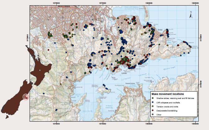
The 22nd February earthquake in Christchurch triggered extensive landslides and rockfalls in the Port Hills area to the east of the city. These mass movements resulted in at least five fatalities, and many homes were damaged. Unfortunately, these mass movements represent a serious long term threat in many areas – in the aftermath of the earthquake several hundred houses had to be evacuated. The science response to the landslide problem was led by GNS Science under the Geonet programme, assisted by partners from the public and private sectors. They have produced an excellent poster describing these activities that is available for download here. The file size is about 1.7 MB.
Perhaps the most interesting data on the poster is a map of the distribution of the different mass movement types:
For reference the image below shows the same area from Google Earth:
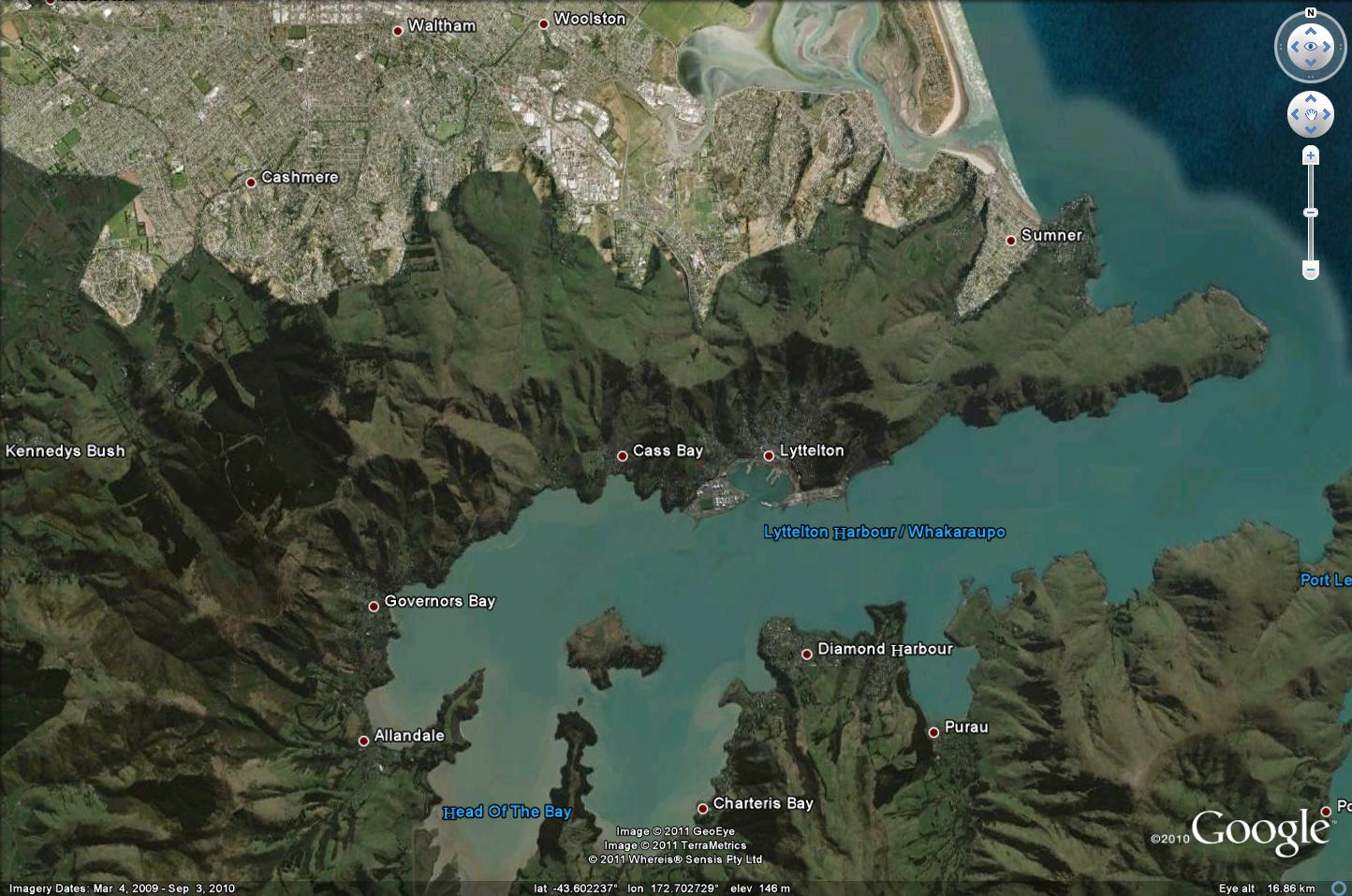
The Google Earth image helps to show the way that the mass movements are concentrated on the steepest slopes, especially the active and abandoned coastal cliffs. There is a very helpful report written by Graham Hancox of GNS describing the helicopter reconnaissance flight that they undertook in the aftermath of the earthquake. Note this is a pdf file, though does not appear to be labeled as such. Firefox couldn’t download it, but Internet Explore had no problems). There are some stunning aerial shots in there, of which I reproduce just two here:

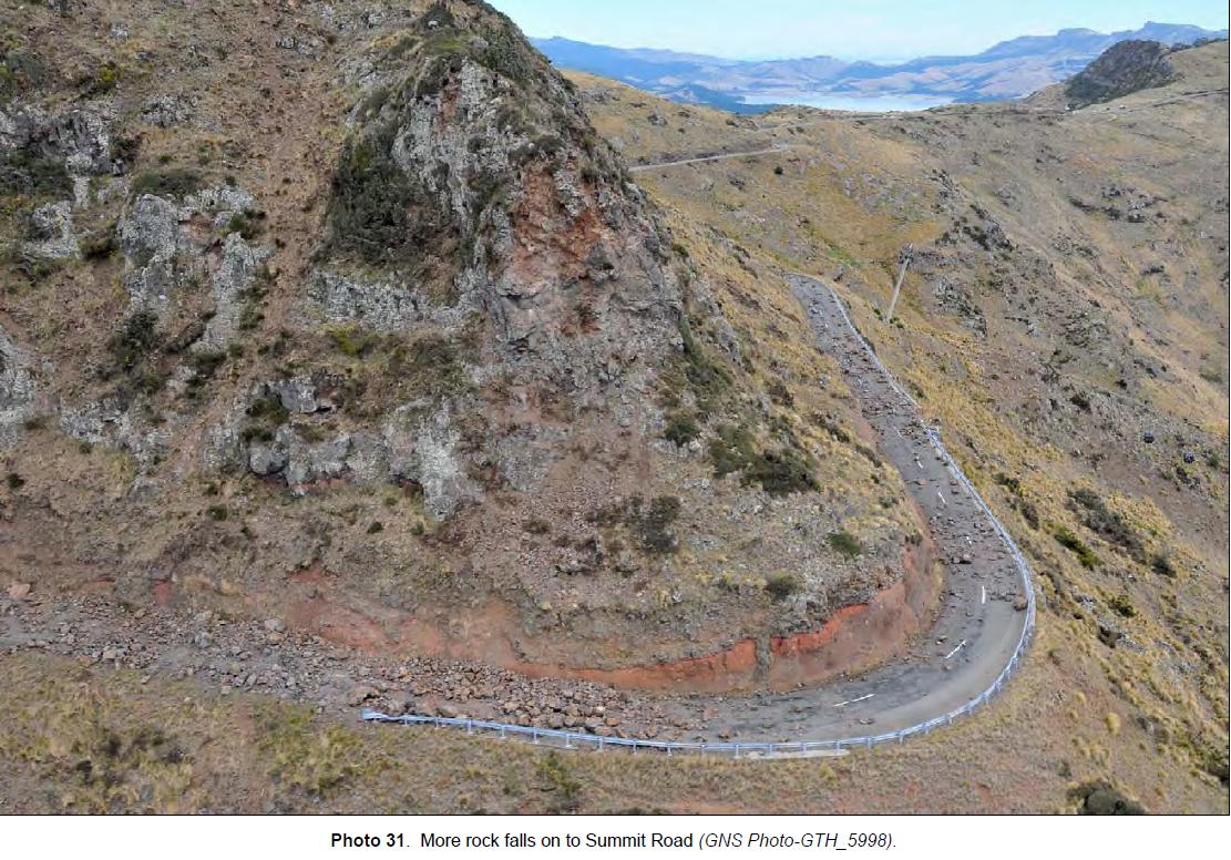
These are remarkable images, which are being backed up with a very comprehensive data collection and hazard analysis exercise. The GNS blog has a short but excellent post outlining some of the work that is being undertaken to understand and mitigate the legacy rockfall hazard, in which with my former PhD student Chris Massey is playing a key role. We will all await the formal reports and scientific papers from this work with great interest.
18 April 2011
Some interesting weblinks about natural hazards
To get things moving in this new week, I thought I’d post a collection of interesting links to articles and sources of information related to natural hazards:
Earthquake hazard in Nepal. The Guardian blogsite has this excellent article on the measures needed to improve preparedness for a large seismic event in Nepal. I can only agree that the vulnerability of Kathmandu is startling, but worry also about the likely impacts in rural areas. Unless we move quickly to address the lack or preparedness a catastrophe is all-but inevitable.
Flood and landslide damage in Victoria, Australia. Most of the media coverage of the floods in Australia has focused upon Queensland, but Victoria has also been seriously affected. The link provides a description of a photo-investigation of the damage to Grampians National Park – there is a gallery of the damage here (click on the left arrow to see most of the images).
EERI reconnaissance report for the Tokuku earthquake in Japan. THe EERI reconnaissance reports for the earthquake and tsunami are now appearing online at this page. These are wonderful resources – much more will appear over the coming months.
EERI reconnaissance report for the Christchurch earthquake. Similarly, EERI has a wonderful set of resources for the Christchurch earthquake too.
Videos of the Japan tsunami. Susan Kieffer’s wonderful Geology in Motion blog has a fabulous compilation of videos of the Japan tsunami. They are extraordinary.
Kofels landslide: The History of Geology has a great post that looks at the extraordinary Kofels landslides in the Alps, highlighting in particular the remarkable variety of theories as to the origin of this landslide.
15 April 2011
Two more landslides in Colombia
The start of the winter season in Colombia is being associated with the dfebelopment of heavy rainfall, resulting in floods and landslides (see link here in Spanish). Yesterday a large landslide occurred near to near El Diamante on the road between Manizales and Bogota. Unfortunately, at the time a small bus was passing through – the landslide is reported to have knocked the bus into a ravine, killing 14 people and leaving a further four missing with little chance of having survived. This report (in Spanish) notes that the bodies were found up to 25 km downstream from the accident site.
The video below shows the accident site. It appears that the even was probably a debris flow:
This accident occurred the day after another landslide, this time in village of Piedras Blancas, San Roque in northern Antioquia, which killed fourpeople when it buried their house.
14 April 2011
Abstract deadline – 11th International & 2nd North American Symposium on Landslides
 Just a brief reminder that the abstract deadline for the 11th International Symposium on Landslides is tomorrow (Friday). Details here. This is the most important landslides meeting of all. It promises to be a great event in a fabulous location.
12 April 2011
Sad news – Stanley Schumm died this weekend

 Sad news this morning that Stanley Schumm, one of the all time greats of geomorphology, died at the weekend. Schumm was ostensibly a fluvial geomorphologist who worked on the dynamics of river systems. There is a great, though now slightly out of date, write-up of his contribution to the discipline on the IAG website. Whilst he did not work explicitly on slopes for much of his career, many of the concepts that he developed have had a huge influence on work in this area.
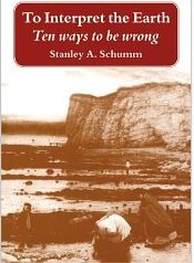
Perhaps most importantly, everyone who works on natural systems should read and digest his book “To interpret the Earth: ten ways to be wrong” (shown to the right). The work is summarised in a that can be accessed from this page (listed under week 15 in the course schedule).
As long ago as 1959 the AGU recognised the contribution of Stanley Schumm with the Horton Award.
11 April 2011
Landslides in art part 10: Charles Emilius Gold
Regular readers will know that I occasionally feature pieces of art that depict landslides. Usually this is the visual arts (i.e. paintings); sometimes it involves music. The previous edition can be found here. Today’s edition was pointed out to me by Anthony Miner in Australia, so many thanks to him.
On 23rd January 1855 a large earthquake occurred in the southern part of North Island in New Zealand. Now known as the Wairarapa Earthquake, it strongly shook the newly established city of Wellington. Although loss of life was comparatively low, the earthquake was significant in that it induced uplift of land across a large area of Wellington, creating new land areas that have subsequently been occupied by the local population. Perhaps most significantly, a strip of land was exposed running along the bottom of the slope that linked Wellington and Lower Hutt, as shown in this Google Earth image:
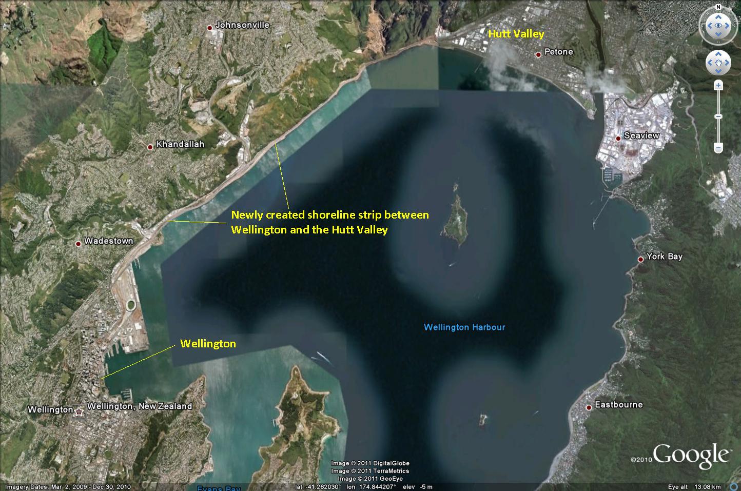
Prior to the earthquake this link was flooded at high tide. This strip of land has subsequently been occupied by both the road and the railway line, allowing the development of the Hutt Valley as a key suburb area for Wellington. However, the earthquake also triggered large numbers of landslides, one of which occurred on the cliffs behind the newly created coastal strip. This landslide featured in a watercolour painting by Charles Emilius Gold:
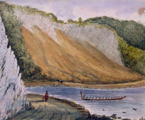
Gold was a senior officer in the British Army and father of 15 children (I wonder how he had time to paint?), who ended leaving New Zealand after a somewhat unsuccessful stay, eventually dying in poverty in Dover in 1871. His rather colourful life is described in detail here – it is worth a read. He painted watercolours of the New Zealand landscape, of which the painting above is one. This landslide was triggered by the earthquake in 1855. Although Gold’s art is in general somewhat simplistic in style, he captures the landslide and the landscape quite well I think. If you look carefully he has even recorded the geological structure in the outcrops. This is quite well illustrated by the Te Ara site, which has a (reasonably) recent picture of the landslide as it is now:
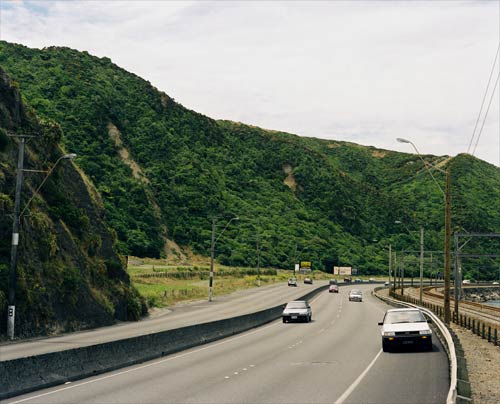
Despite the revegetation and the reclamation of land to create the road bench, the site is clearly recognisable from the painting.
I welcome any thoughts or comments, and suggestions for future posts in this series.
7 April 2011
An interesting new video of a landslide in action
Thanks to Tom Hodgson for pointing out this one. A new Youtube video of a landslide in action has appeared in the last couple of days. Whilst it is not the largest slide, the quality of the video is excellent – it should be visible below:
This slide occurred on Nelson Road in Santa Cruz County of California. There are a few interesting things to note. First, the ground is dry, as is the landslide itself. Second, note how the main event was preceded by precursory activity, with an increasing event rate. Finally, note how abruptly the movement ceased, and the smoothed out morphology that resulted. If there is a lesson from this it is that trying to pass by a slope that is spalling rock in the manner that was occurring at the start of the video is highly dangerous.
5 April 2011
An interesting landslide on Highway 101 in California
Thanks to Drew Barber and to Brian Huggett for bringing this one to my attention – and apologies to them for my tardy post!
California has suffered a prolonged period of rainfall in recent weeks, which unsurprisingly has resulted in significant landslide activity. Of particular note is a slide on Highway 101 in Humboldt County about 8 km to the north of Garberville that occurred last week. This image, collected by Felix Omai, shows the landslide rather well:
Note the cars on the lower left for scale. There are two great galleries of images of the landslide. First, Felix Omai has a Flikr gallery that has views of the slide from both the ground and the air, including the clean up operation. Second, Redheaded Blackbelt has a commentary as well, also with some great images (but can I caution that this site takes a counter-culture view that I am not endorsing) here . The latter site also has a very interesting commentary from the perspective of a land owner on another landslide in this area, which is worth a read.
In many ways the most interesting aspect of this landslide is the deformation that it has caused to the roadway. As the landslide has moved onto the highway the asphalt appears to have effectively delaminated from the sub-base. The landslide effectively imposes a vertical load and a horizontal compressional force on the surface layers. The result is a series of fascinating features, as shown in the images below (from here):

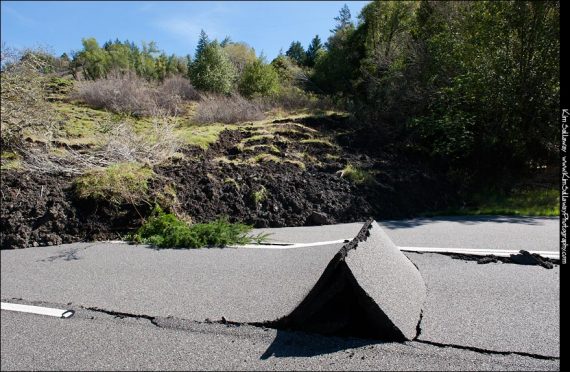
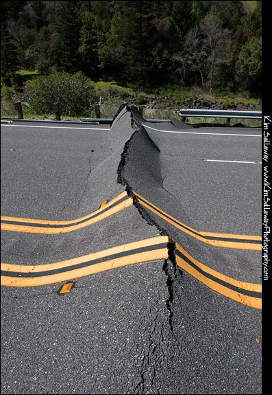
Reports suggest that the landslide has now been cleared, the surface has been resealed and the road reopened.
1 April 2011
A large landslide in Thailand
Over the last few days torrential rainfall has affected parts of Thailand, causing very substantial levels of damage. The NASA TRMM satellite has captured some good data on the location and extent of this rainfall event, which is nicely described in this article from PhysOrg. The rainfall extent is clear from the image below from that article:

Landslides appear to have been triggered quite extensively. The largest seems to have occurred at Ban Ton Harn in Khao Phanom district of Krabi province, where a large and highly energetic debris flow has destroyed the village. The final toll from the landslide is a little unclear, with estimates varying substantially, but five people have been confirmed as having been killed. The Bangkok Post has an impressive gallery of images of the landslide, of which these two are probably the most startling:

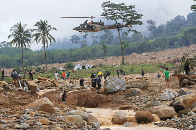
The size of the boulders here is clearly notable; given that the village was directly struck by the event, the death toll seems surprisingly low. A more detailed description of losses across Thailand from this heavy rainfall event is provided in this article, which indicates that more than 800,000 people have been affected, and 13 killed.
Of course, once again the UK media have focused on tourists having their holidays ruined.
 Dave Petley is the Vice-Chancellor of the University of Hull in the United Kingdom. His blog provides commentary and analysis of landslide events occurring worldwide, including the landslides themselves, latest research, and conferences and meetings.
Recent Comments