

24 December 2012
Four landslide videos for Christmas
There are four interesting landslide videos on YouTube today. The first is a recap of the landslide that derailed a freight train at Everett about a week ago. This is the original video however, showing the slope before the collapse:
The small slips before the main collapse are incredibly interesting. The probably indicate that the whole soil mass was moving and deforming, triggering these little collapses. It would be interesting to see if the rate increases with time – in most cases this is what happens. Of course the main collapse event is also worth viewing again.
The second is a landslide in a forest in California. Excuse the commentary, which succeeds in saying little in rather too many words, but the landslide event itself is quite interesting, especially towards the end of the video:
http://www.youtube.com/watch?v=Xf6nOWi_22Q
The third is a very strange video of a riverbank collapse in China. I don’t know the story behind this, but it was clearly something of a surprise for those with the camera!
http://www.youtube.com/watch?v=dCH6k58_FYw
And finally this is quite a cool video of a shallow soil slide in Swanage, Dorset over the weekend, resulting from the next bout of rainfall in this extraordinary period in the UK:
http://www.youtube.com/watch?v=-1yYhSMqPZw
20 December 2012
Updated: Another bout of landslides in the UK today
Updated below with additional landslides
The UK is today receiving the effects of another intense rainfall event, as the Met Office Rain Radar image below shows:
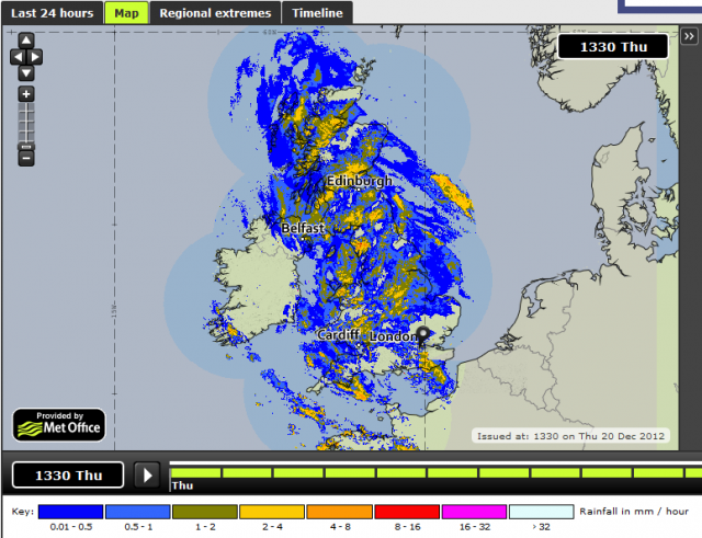 .
. This rainfall, although not truly exceptional, is falling onto ground that has been left saturated during repeated bouts of recent precipitation, leaving conditions that favour landslides and floods. Unsurprisingly then reports of landslide activity are starting to appear on the newswires and on Twitter, with more to come. News of landslides so far includes:
- The A83 at Rest and Be Thankful in Scotland is once again under a landslide warning (this is a common landslide hotspot).
- There are reports of a landslide at Frog Lane in Braunton, Devon.
- The A386 in Weare Gifford in Devon is blocked in a landslide
- Trains between Fareham and Eastleigh in Hampshire are not running because both lines are blocked by a landslide (from Twitter)
- Quarry Lane in Exeter in Devon is partially blocked by a landslide (from Twitter)
- B4195 Stourport Road is closed by a landslide (from Twitter)
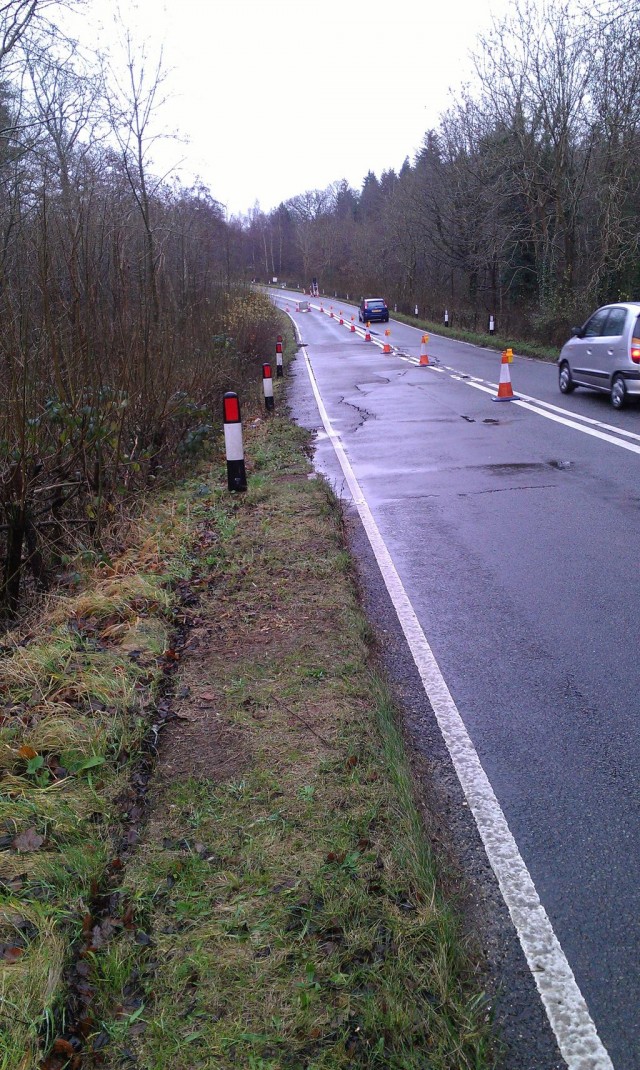
- There is a progressive failure occurring on the Oxford Road near Boars Hill. Image from Twitter by Freddie Whittaker:
- Back Lane in Swainby, North Yorkshire is closed due to a landslide
The situation seems particularly serious in the Isle of Wight, here there seems to be many incidences of floods. This twitter feed provides good coverage of these problems. The southern side of the Isle of Wight is a world-famous landslide prone area, so the long-term effects of this rainfall will be very interesting. The recent heavy rainfall has already caused multiple closures of coastal paths, especially in South-West England; expect more in the coming months.
The rain is expected to clear away overnight, but there is another large event forecast for tomorrow evening and into Saturday. More landslides seem inevitable, especially now that the deep-seated landslide systems seem to be active again.
19 December 2012
Unbelievable – a video of a landslide striking and derailing a freight train in Everett, near Seattle, USA
Thanks to Stephen Newman and Chris Nowak for pointing this out. On Monday a landslide derailed a freight train Everett, near Seattle in Washington State, USA. Amazingly, it was caught on video:
14 December 2012
Images of a railway landslide in the Canadian Rockies
Thanks to Allan Galanty for highlighting this one and for providing the images.
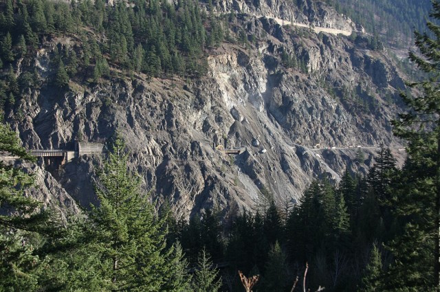
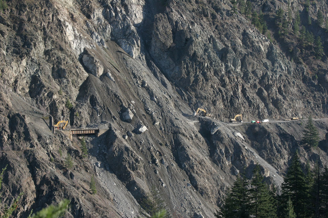
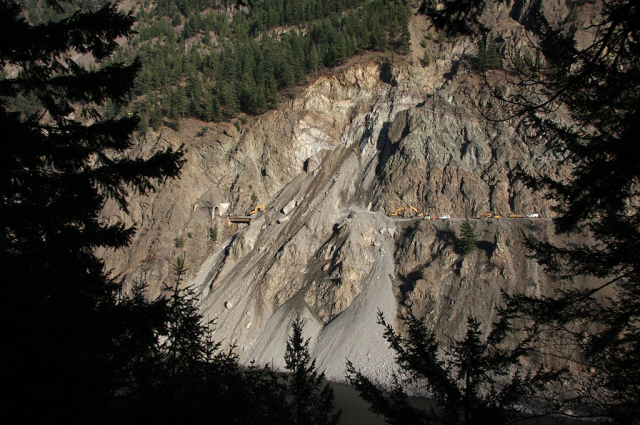
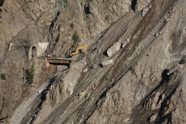
On 24th November a rockslide occurred on the CN mainline railway track in the Ashcroft subdivision of western Canada. The landslide buried a section of line. removal of the debris to reopen the track will have been far from simple:
13 December 2012
Levels of loss of Typhoon Bopha / Pablo
Although Typhoon Bopha / Pabol has now faded from the pages of our newspapers, the death toll continues to rise. The latest NRDDMC Bulletin indicates a total of 902 confirmed fatalities and an additional 934 people reported missing, suggesting that ultimately the number killed will be somewhere over 1500 (bearing in mind that some of those reported missing may turn up). In total almost 150,000 houses were damaged, of which almost 61,000 have been declared as a total loss. Estimated economic losses are about US$350 million. 5.5 million people have been affected by the storm.
Landslides have probably claimed many victims. At one end of the scale, a garbage slide claimed a single life in Zamboanga City, whilst elsewhere hundreds of lives have been lost in debris flows.
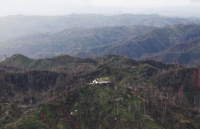
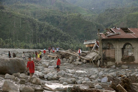
Slowly, images of the landslide events are appearing, although it will still be some time before the true picture emerges. Apart from the debris flow at Barangay Andap that I showed previously, landslide images include:
Multiple shallow landslides and felled trees:
The really big loss areas appear to be:
Caraga, Davao Oriental: 20 death.
Baganga, Davao Oriental: 143 deaths, 38 missing
Cateel, Davao Oriental: 181 deaths, 54 missing
Boston, Davao Oriental: 32 deaths, 4 missing
Monkayo, Compostela Valley: 107 deaths, 9 missing
New Bataan, Compostela Valley: 239 deaths, 485 missing
Compostela, Compostela Valley: 31 deaths, 6 missing
Pantukan, Compostela Valley: 25 deaths, 1 missing
10 December 2012
So who said science isn’t fun? A full-scale (820 m runout) debris flow experiment
Whilst waiting for a flight home this morning, I stumbled across this video of a full-scale debris flow experiment in South Korea, which I think was presented at the AGU Fall Meeting last week. This is remarkable and of course fun (though needs great care). Although the video is over four minutes long, keep watching until at least the 2 min 40 sec point. There is no greater illustration of the hazards posed by such a debris flow, even though this was quite small at the start:
.
Wow!
8 December 2012
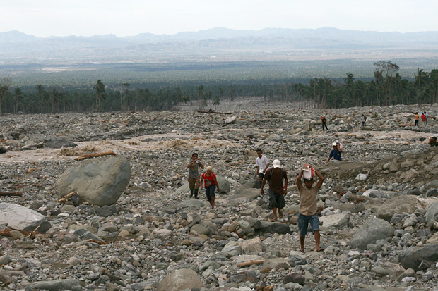
So just how bad was the debris flow at Barangay Andap during typhoon Bopha / Pablo ?
.This bad – the village was in the middle of the valley (image from MindaNews):
http://www.mindanews.com/tag/typhoon-pablo/
.
It is hard to imagine what this would have looked like in reality. The answer is something like this:
.
This is the very cost of the failure of effective disaster risk reduction, and the continuing unwillingness to address climate change.
7 December 2012
Evaluating the causes of the Typhoon Bopha / Pablo disaster
As the death toll from Typhoon Bopha / Pablo steadily mounts (the latest NDRRMC reports suggest that 418 people were killed and 383 are missing), the recriminations about the causes of the devastating debris flows that were responsible for so much of the loss has begun in earnest. In the worst affected area, Compostela Valley, an argument has started as to the degree to which mining was responsible for the loss. This is a legitimate question to ask, but in my view it misses the point. Let me show you why.
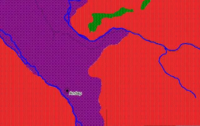
Lets take for example the village of Andap, which was devastated in the Typhoon., with at least 80 fatalities. The Philippine Mines and Geology Bureau has generated a useful set of hazard maps, and these are online here. This is an admirable task that is way in advance of that in most less developed, and indeed many developed, countries. This is the portion of the sheet for Andap:
.
The red areas are zones of high landslide susceptibility, the green areas of medium landslide susceptibility and the purple areas of high flood susceptibility. Now, I am quite sure that this is right – that is the case for all of these areas. However, it is not much use to those that live here – the maps basically indicate that everywhere is dangerous, with 90% of the land being highly dangerous. In an ideal world one might argue that all the people in this area should relocate, but leaving their villages and land is probably not practical – for example it will introduce many other risks to these peoples’ lives. These risks may well outweigh those associated with the natural hazards.
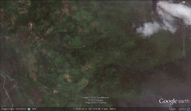
So let’s take a look at this area, suing the Google Earth imagery. This is an overview of the area (I am not sure exactly which village is Andap, but in this context it does not matter):
 .
.
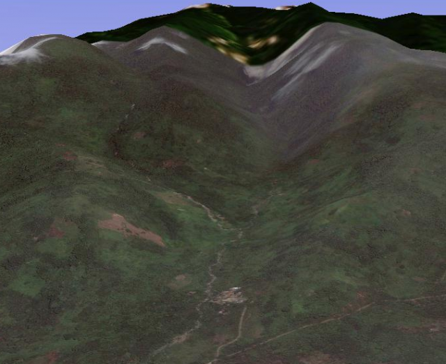
A perspective view is actually a little more helpful, let’s take the more southerly of the two villages above:
 .
.
This is a classic debris flow channel, with steep slopes and a very narrow mouth. In very heavy rainfall, debris flows would come roaring down the valley, destroying everything in their path. The potential for the headwaters of the channel to be blocked with debris makes the hazards even more acute. In short, this is a very dangerous place to be at the bottom of valley in very heavy rainfall, irrespective of whether there has been mining upstream.
In that context, the location of the village is deeply concerning. Right by the channel at the mouth of the catchment is about the worst place this could be located. And this is common across the area, explaining why the losses were so high. Although the risk of landslides here is high everywhere, being away from the channel itself on the valley sides is much safer. Of course the maps do not indicate this.
So really the needs are clear. First, mapping needs to be undertaken on a case by case basis to determine which communities are most at risk. Second careful thought is then needed as to the best way to protect the people. This should not be a simple, blind relocation exercise – that does not work in most cases. It could be that the village can be relocated completely (if this is done with great thought and care), or it could be protected with a structure, or it could be that the local people can be educated as to how to respond (and where to move to) in heavy rainfall,etc. All of these are essentially social as well as technical solutions – the right approach is a combination of both Of course all of this costs money, and the Philippines is desperately poor, so external aid is needed to help with this. But if such an investment, in an area that we know is desperately hazard prone, would have been much cheaper than trying to deal with the mess in the aftermath of the typhoon, and of course at least 80 people would still be alive.
The frustrating thing is that I and many others have been banging this drum for years, but we have had very little traction. There is a host of people, including myself, willing to help; it is good to see that in the last year or so the national aid agencies have started to take this seriously. I really hope that this preventable event is the catalyst for the required action. It would be relatively simple, although time consuming and not wthout cost, to reduce losses at a place like this drastically.
6 December 2012
Landslide losses from Typhoon Bopha / Pablo
The last 24 hours has seen the inevitable if depressing steady increase in the reported losses from Typhoon Bopha / Pablo in the Philippines. According to the latest NRDDMC report, the current confirmed death toll stands at about 322, although this is expected to rise further as 378 people are reported missing. The frustration of course is that this level of loss was very predictable, although without the preemptive evacuations it is likely that it would have been very much higher of course. This shows all too clearly that it is not possible to achieve genuinely effective disaster risk reduction with short-term measures. Long term planning is required, and countries such as the Philippines need external support to be able to implement effective measures.
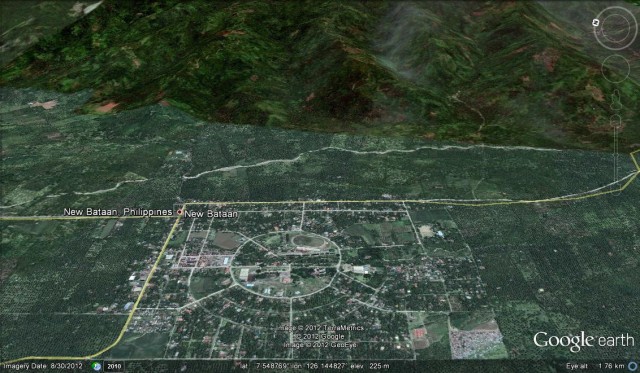
The most seriously affected area appears to be New Bataan in the Campostela Valley. This is the Google Earth perspective view of the town, presumably the debris flows were sourced from the mountains in the background:
 .
.
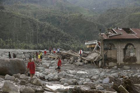
The NRDDMC data indicates that 86 people ae confirmed dead and a further 343 people are missing in New Bataan, a genuinely appalling toll. Another 55 people are reported to have been killed and eight are missing in a landslide in Monkayo in the same area. At the moment, there are few images that give a perspective on the actual events at New Bataan, but this one, from here, suggests large-scale debris flows from the mountains:
..
This is consistent with the most detailed report of the events in New Bataan, from this news report in the PhilStar, which states:
The farming town of New Bataan in Compostela Valley lies far from the river, so residents thought they were safe from flooding as typhoon “Pablo” barreled across Mindanao. At around 4 a.m. on Tuesday, however, amid raging wind and pounding rain, residents heard a thunderous sound. And then a wall of mud and debris, followed by rampaging waters, came crashing down into the town. In minutes, houses were washed away and two army camps manned by troops preparing for search and rescue operations were wiped out. Similar scenes played out in other parts of the province….Lt. Col. Lyndon Paneza, spokesman for the Army’s 10th Infantry Division based in Mawab town, said heavy rains dumped by Pablo in the province on Monday triggered a landslide in the mountains that blocked an upstream river in New Bataan. Before 8 a.m. on Tuesday, the river burst its banks and mud and water came rampaging down to New Bataan. “Our troops and the civilian residents in New Bataan never expected the flash flood as the area is far from the river,” Paneza said.
4 December 2012
First news of the impact of Super Typhoon Bopha (Pablo) – a major flash flood / debris flow has killed 44 people
As dawn breaks in the Philippines this morning the first reports are starting to come in of the damage and losses associated with Ttphoon Bopha (Pablo) yesterday in Mindanao. It is important to stress at this point that the storm os certainly not finished as yet – later today it will cross Palawan and then it is expected to lurk to the west of the Philippines for a few days, drawing in heavy rainfall across the nation in the process. Reports at the moment are understandably patchy, especially from isolated rural and coastal areas. The largest loss thus far appears to be in Campostela Valley, This area, which has many mines, has a long history of landslides (see this previous report for example). The incident during the passage of Bopha is variously reported to be a flash flood or a landslide – in most cases this means that the event was a debris flow in my experience. It occurred at an army base at Barangay Andap in New Bataan, killing 44 people. The exact circumstances are still unclear, but more information will almost certainly become available during the day.
GMA News has a video, which should be visible below, which shows a landslide being cleared. I do not think that this is the event described above, but I don’t speak Tagalog:
.
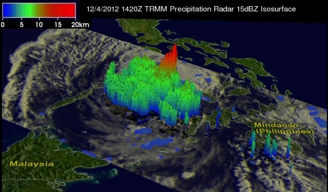
The NASA TRMM satallite passed over the Philippines yesterday at 14:20 UT. NASA have released an image showing the precipitation around the typhoon at that time:
.
Whilst Bopha is now less strong, having lost its source of energy as it passed over Mindanao, it is still a very intense storm. Palawan is quite vulnerable to a large typhoon, so there remains the potential for significant impacts. However, the authorities and population of the Philippines deserve credit for the level of preparation for this storm to date. This has undoubtedly saved lives.
The best source of information about the impact of Bopha over the next few days will be the NDRRMC website. they publish a hugely detailed bulletin at least once per day that describes in great detail the disruption and losses associated with the typhoon. The most recent one is here.
 Dave Petley is the Vice-Chancellor of the University of Hull in the United Kingdom. His blog provides commentary and analysis of landslide events occurring worldwide, including the landslides themselves, latest research, and conferences and meetings.
Recent Comments