
16 January 2013
New research: extreme precipitation and landslides in 2010
![]() As regular readers will know, since 2002 I have been maintaining a database of landslides that kill people worldwide (and this work was recently published in the Journal Geology). In that dataset 2010 is the year with the highest level of losses from rainfall-induced landslides – it truly was a remarkable year. In a recent paper (available online here and published behind a pay wall in the Journal of Hydrometeorology), Dalia Kirschbaum from NASA and colleagues (Kirschbaum et al. 2012) have used their own catalogue of mass movement events to examine the relationship between landslides and heavy rainfall. The landslide catalogue that they have used is rather different to mine because it compiles information about all reported rapidly moving landslides, irrespective of their impact. As such it is more comprehensive than my dataset, although it may be more subject to the vagaries of media and other types of reporting. In this study, the catalogue has been compared with precipitation data from the TRMM satellite. The TMPA dataset that they have used combines the TRMM data with rain gauge data to produce daily global rainfall dataset at a resolution on 0.25 x 0.25 degrees. This dataset is known to represent large rainfall events quite well.
As regular readers will know, since 2002 I have been maintaining a database of landslides that kill people worldwide (and this work was recently published in the Journal Geology). In that dataset 2010 is the year with the highest level of losses from rainfall-induced landslides – it truly was a remarkable year. In a recent paper (available online here and published behind a pay wall in the Journal of Hydrometeorology), Dalia Kirschbaum from NASA and colleagues (Kirschbaum et al. 2012) have used their own catalogue of mass movement events to examine the relationship between landslides and heavy rainfall. The landslide catalogue that they have used is rather different to mine because it compiles information about all reported rapidly moving landslides, irrespective of their impact. As such it is more comprehensive than my dataset, although it may be more subject to the vagaries of media and other types of reporting. In this study, the catalogue has been compared with precipitation data from the TRMM satellite. The TMPA dataset that they have used combines the TRMM data with rain gauge data to produce daily global rainfall dataset at a resolution on 0.25 x 0.25 degrees. This dataset is known to represent large rainfall events quite well.
Perhaps unsurprisingly, the landslide dataset used here also show unusually high levels of landslide activity in 2010, with the increase above normal levels occurring primarily in Central America, the Himalayan Arc and Central-Eastern China. In each case, the authors clearly show that the elevated levels of landslide activity were associated with rainfall levels that were above normal. So, for example, this is the data for South Asia
 .
. The top graph presents the precipitation data for this region. The red line is the precipitation pattern for 2010, whilst the green line is the average over 12 years. It is clear that the summer monsoon in this season was much wetter than the medium term average. The second (lower) graph presents the number of reported landslides in 2010 (in orange) and the average number of reported landslides for 2007-2009 in blue. Clearly the landslide occurrence level was significantly higher than in previous years; the obvious potential cause is the higher levels of precipitation. The other areas show similar patterns.
Now, in some ways it might be obvious that years with larger rainfall totals, and in particular more extreme events, are associated with more landslides. Indeed, no-one is terribly surprised that the recent wet weather in the UK has been linked to a much higher occurrence of landslides across the country. From that perspective, this paper is confirming what we already know, although the importance of exploring and quantifying an accepted truth can be underestimated.
However, this contribution is much more important for two reasons. First, the fact that we can combine different datasets in this way to produce a useful analysis provides a basis upon which to start to better understand spatial and in particular temporal patterns of landslides. Kirschbaum et al. (2012) start the process of examining the relationship between the observed landslide patterns and global weather systems, such as the El Nino cycle. They suggest for example that it is now established that in the year after an El Nino event, rainfall levels in the Himalayas are higher than normal, which explains the patterns in 2010. This is really useful information that will help improve management and mitigation of landslides in the future. Much more work of this type is needed, but this research opens the doors to it.
Second, the analysis suggests that combining these datasets provides a much better way to understand those areas that are at long-term risk from landslides. This is likely to be a much more robust approach than the existing global landslide hazard and risk maps, such as those generated by the World Bank hotspots project. Such approaches need more work, and this will take time, but in due course we should be able to identify those regions that are landslide-susceptble to a much better degree than at present. Of course we also need to do something similar for earthquake-triggered landslides, but the low-level of occurrence of earthquakes will make this rather more difficult.
Reference
Kirschbaum, D., Adler, R., Adler, D., Peters-Lidard, C., & Huffman, G. (2012). Global Distribution of Extreme Precipitation and High-Impact Landslides in 2010 Relative to Previous Years Journal of Hydrometeorology, 13 (5), 1536-1551 DOI: 10.1175/JHM-D-12-02.1
14 January 2013
The Yunnan landslide and its relationship to earthquakes
The final count of lives lost in the landslide in Yunnan Province in China last week is 46 people, of whom 17 were reported to be children. All of the bodies have been recovered – which given the size of the landslide is a remarkable achievement – but in China there is some controversy about the decision to cremate the remains without the permission of the relatives. It is not clear why this decision was taken, which does not accord with the religious traditions of the community affected.
Meanwhile, there is more information about the landslide in an article in the Global Times. This reports that the landslide was 120 meters long, 110 meters wide and 16 meters deep, which seems surprising given the images that first appeared in the aftermath of the landslide:
 .
.
The landslide occurred in an area with coal mines, but the report rules out a link between the failure and these activities, instead drawing attention to the effects of both bad weather and the legacy of the M=5.6 and M=5.3 Yiliang County earthquakes on 7th September 2012. The link with the earthquakes not unreasonable at first inspection, and once again emphasizes the importance of the post-earthquake legacy of landslides, but the timing seems quite strange to me.
Finally, China Today is reporting that the 629 inhabitants of Gaopo Village will now be relocated. Even before the earthquake the area appears to have been under threat from landslides – the China Today article notes that there is a sign in the undamaged school that reads:
“Try to run and avoid the area if a landslide occurs,” reads a faded safety message printed on an outdoor blackboard at the Gaopo Middle School.
Of course knowing where to run is critical – trying to outrun a fast-moving landslide is unlikely to be successful. In general, instructing people to run away is not on the ideal list of landslide risk reduction approaches.
11 January 2013
At least 18 killed in a landslide in China
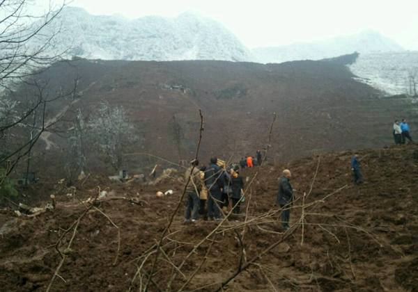
Chinese News agencies are reporting that a landslide overnight buried 16 households in Gaopo Village of Zhenxiong County, in Yunnan Province, China. Whilst estimates vary as to the number of known fatalities, CRIEnglish reports 18 confirmed deaths from a total of 40 people buried in the landslide. On the other hand, China Daily is reporting 16 deaths and 37 people unaccounted for, so it seems inevitable that the fatality count will rise further.
The timing of this event looks interesting and perhaps surprising. The images of the landslide seem to show a thin covering of quite fresh snow, which is not an obvious condition for landslide triggering. The overview image, shown below, is also interesting:

http://english.cri.cn/6909/2013/01/11/2702s743084_2.htm
Judging by this image, the landslide was a reasonably rapid flow consisting mainly of mud and soil rather than bedrock:
http://usa.chinadaily.com.cn/china/2013-01/11/content_16106028.htm
Whilst it is too early to know for certain, I wonder if even the overview image above might be just the lower portion of a rather larger landslide somewhere in the hills upstream of the village, although I remain confused by the apparent small failure in a bluff on the far right of the first image. This does not on first inspection seem large enough to be the source of this landslide, unless there was a huge amount of entrainment (picking up of debris) along the way. It is all quite strange – an aerial image would be very interesting.
9 January 2013
An interesting Austrian earthflow video
In the last few days there has been a number of landslides in Austria caused by heavy rainfall. The BBC has a short video report that includes a nice piece of footage of a large earthflow inundating a road:
http://www.youtube.com/watch?v=Pa4vc2feXBQ
.
This apparently happened near to Salzburg. Earthflows are rarely caught on video, so this is a good addition to the collection of available footage. An interesting aspect of this is the increased rate of movement of the frontal portion as it started to runout. This may indicate that the material weakened as it remoulded during movement or that the road provided a low friction surface to run across, perhaps?
8 January 2013
Increased occurrence of landslides in the UK in the last year – and the relationship to rainfall
The British Geological Survey have posted a nice piece on their website about the increased occurrence of landslides in the UK in the last year. This includes the following graph, which shows rather well just what an extraordinary year 2012 has been, and in particular the increased occurrence of landslides in December:
 .
.
Interestingly, they also include a map of the landslides that have occurred around the UK in the last few weeks:
 .
.
Note that there is a big cluster of landslides in Southwest England and then extending northwards to North Yorkshire, with a smaller number scattered around the rest of the country. It is interesting to compare this uneven landslide distribution with rainfall data. This is the Met Office rainfall anomaly map for 2012:
 .
.
Note that this is variation from average rainfall – i.e. the dark blue areas had >135% of average rainfall for that area. The general pattern is clear – even if the fit is not perfect – in areas in which rainfall anomalies were hig for the year the occurrence of landslides was in general also high. Although this is unsurprising, it is a nice illustration of the ways that rainfall changes drive landslide triggering in the UK.
5 January 2013
Remarkable photos of a collapsing arch in California
Robert Wills is a PhD student at Caltech. On 29th December 2012 he was walking with his family on Tennessee Beach, north of the Golden Gate Bridge in San Francisco, California. This beach features a spectacular arch 30 m above the ground cut into the cliff face. The day was stormy with large waves. Robert describes on his blog what happened next:
As we were admiring the waves, a crack and the ensuing sound of a waterfall of rocks caught our attention and everyone on the beach spun to see a small stream of rock flowing down the cliff face below the arch. This was exciting enough that we kept our cameras out and ready and our attention on the arch. I was hoping to get another such small rockslide because I liked how it looked in a picture, a brown waterfall emanating from a hole in the wall. I could never have expected what happened next. Two minutes later, just as I was hoping, a few chunks of rock fell from the underside of the arch and I started my camera. Then the arch started to buckle in on itself and squeeze out rock from beneath it. With this, the collapse of the arch shortly followed and the entire surrounding hillside started to slip off into the ocean in a thundering roar as boulders the size of a piano crashed into the surf and the sand sending up a large splash of debris that got me a little nervous despite my 100-meter distance. It all lasted less than 10 seconds and left the beach quiet in comparison, the roar of the surf nothing compared to the thunder of the rockslide. The small crowd of 15 or 20 people stood in awe, wondering if the show was over. The main event was over, with only one smaller rockfall in the next 20 minutes, but the scene was still fascinating, with waves washing over the fresh pile of rock turning the ocean brown.
Remarkably, he caught the entire event on camera with an incredible set of photos. I thoroughly recommend that you visit his website to take a look, it actually has two different set of images of the same event (the other set caught by Chris Wills of the California Geological Survey). As a taster I will reproduce (with Robert’s permission) three images from the sequence:
Before:
 During:
 After:
 There are many more images on Robert’s website. Do take a look – they are astonishing perspectives on a collapse event.
4 January 2013
A round-up of recent landslide stories and incidents
A few landslide stories and incidents that have caught my eye in the last few days:
1. Fears of landslides in Rio de Janeiro
January 2011 was marked by a series of terrible landslides in Brazil, that caused extensive loss of life and damage. Unfortunately, news reports suggest that this area is again suffering very heavy rainfall, with fears that landslides will once again be a major issue. Hopefully this will come to nothing, but this will be worth watching over the next few days and weeks.
2. Another landslide in Malaysia
Thanks to John Oostenryk for the heads up on this one. Another landslide occurred in Malaysia last night – this time a mud flow at Subang Jaya – which inundated seven vehicles. NST has an image of the aftermath:

http://www.nst.com.my/latest/7-vehicles-buried-by-landslide-in-subang-jaya-1.195962
No-one was killed or injured, but the incident does further emphasize the need to manage slopes in Malaysia more proactively. Meanwhile, demolition of the houses at the top of the Bukit Setiawangsa landslide continues. Media interest in this story remains very high in Malaysia, and today there is extensive coverage of the news that the house owners won’t be compensated for their losses.
3. An interesting landslide in New Zealand
On Wednesday a large landslide occurred in response to heavy rainfall at Kahurangi National Park in the northwest corner of South Island,leading to helicopter rescues of several trekkers caught on the wrong side of it. Radio New Zealand has an image of the landslide, which has an interesting morphology:

http://www.radionz.co.nz/news/regional/124823/trampers-lifted-out-of-national-park
4. Further landslide problems in the UK
Although the heavy rainfall appears to have abated, for the next few days at least, high groundwater levels are as expected leading to ongoing landslide problems across the country. Issues include coastal landslides in East Anglia, Dorset and the Isle of Wight; road closures in Northumberland, Shropshire and Oxfordshire; and of course the ongoing landslide problems in for example Wales. Expect more landslide stories in the coming weeks as deeper landslides continue to activate and move. Meanwhile there is an interesting and reassuring interest now in the implications of the changes in rainfall patterns that are affecting the UK. As the report indicates, more research is needed. This is somewhat urgent now.
3 January 2013
Greater clarity, and some controversial media statements, about the Bukit Setiawangsa landslide in Malaysia
Over the last few days it has become much clearer as to what happened at Bukit Setiawangsa in Malaysia on 28th/29th December. In particular, better media images suggest that this was indeed a large-scale, probably rotational, failure behind and through the engineered slope. Probably the best image gallery can be found here, which includes this shot :

http://fz.com/content/cliffhanger-setiawangsa
This aerial view is also very helpful:

http://mynewshub.my/2012/12/31/benteng-60m-di-bukit-setiawangsa-tertinggi/
Great care is needed in over-analysing these images to come up with definitive statement on the cause of this failure as this appears to be a landslide that is more complex than it might initially appear. For example, on the left side of the slope (as it appears on the image above) the boundary of the failure appears to lie at the edge of or even outside of the reinforced slope (it is a strangely linear lateral scarp) for most of its length. In the lower portion though the scarp cuts back through the concrete. Note the additional deformation (buckling of the concrete) in this lower portion of the slope as well. Indeed, it appears that there is more movement on the left side of the landslide than on the right (note the tilt in the displaced structures at the top of the dispilaced mass).
Meanwhile, there is a distinctly curious press report about the landslide in the online version of The Star newspaper, quoting Prof Dr Tajul Anuar Jamaluddin, an Associate Professor at Universiti Kebangsaan Malays. The article says:
‘Shotcrete’ caused collapse
The Bukit Setiawangsa landslip was likely caused by the unsuitable slope protection method used for the hill, according to experts. Universiti Kebangsaan Malaysia Assoc Prof Dr Tajul Anuar Jamaluddin said the wall used to protect the slope was known as a “shotcrete” wall which prevents water from entering the soil. “However, water can still seep into the slope from areas not covered by the wall but the wall also prevents water from flowing out. In other words, water can flow in but not out. When this happens, the groundwater pressure builds up and breaks through the wall, causing the landslip,” he said when contacted
Dr Tajul, who teaches geology, said shotcrete walls were also not meant to be built on highly metamorphic rocks at Bukit Setiawangsa, which are not strong enough. “The proper slope protection for such rocks should be something permeable like a high tensile strength wire mesh wall. This method allows water to seep in and out and vegetation to grow to prevent erosion,” he said. Dr Tajul said that improper use of the shotcrete wall was common in Malaysia. “Shotcrete walls should only be applied for granite slopes which are solid. However, they are commonly used because they are three to four times cheaper than the permeable walls,” Dr Tajul said. He added that the Bukit Setiawangsa slope was cut too high and steep at 60° while houses were built too close to the edge. Sensitive land development specialist Dr Tew Kia Hui said shotcrete walls were designed to prevent erosion but should not be constructed in areas with unstable earth. “Such walls cannot withstand a heavy load above the soil. This includes houses, apartments and boulders,” he said.
Of course I have no idea as to whether these are correct quotes, or if they have been taken out of context, but they seem to be to be strangely misleading. These comments have already been addressed in a letter from the Institution of Engineers Malaysia, but let me add some thoughts.
First, whilst shotcrete might have been used to provide the final finish, this is not really what one would consider to be a shotcrete wall. In this slope the primary strength was probably provided by the prestressed ground anchors (which are the pairs of studs that can be seen across the surface). Frequently in failures of this type the ground anchors either failed to penetrate the slip circle or they were not sufficiently strong to provide the necessary additional strength to the slope (which may be because the anchors were too weak or the strength of the soil was incorrectly evaluated). I have no way of knowing whether this was the case here, and it is not sensible to speculate at this stage.
Second, drainage may or may not be a problem at Bukit Setiawangsa, but there is no reason why an engineered slope of this type should lead to drainage problems if properly designed. The key issues are to ensure that adequate drainage holes are provided and that these are maintained correctly. I am sure that the forensic investigation will look at this carefully.
Third, when engineered slopes like this fail they do not do so because the water pressure breaks through the shotcrete. They do so because the rock / soil mass displaces.
Fourth, engineered slopes such as this are in common use around the world, with great success. If properly designed there is no reason why they should be avoided in this sort of setting or lithology. I remind regular readers of the absolutely amazing ship lock wall at the Three Gorges Dam site, which I featured last year. This slope is 102 m high:
 .
.
Fifth, the last thing that anyone would ever use in this situation is a wire mesh wall. The images above show that this slope is in weathered residual soil; a mesh could not retain such a material (which would flow through the gaps) and would not provide sufficient strength to avoid a rotational failure. Wire mesh walls have their uses; this is not one of them.
Sixth, I am surprised at the comment at the end by Dr Tew Kia Hu, which seems to imply that engineered slopes cannot have structures at the crest. I wonder if he was aware that this is a slope with ground anchors rather than just shotcrete (which would explain the comment). Actually the buildingst Bukit Setiwangsa are very light weight in comparison with the mass of the slope, and are unlikely to be the cause of the problem. Elsewhere, really big structures are built at the crest of engineered slopes, but of course the design does need to be appropriate.
Of course, Malaysia recently completed a National Slope Masterplan to reduce the occurrence of these sorts of events. The correct approach here is of course first to ensure that the slope at Bukit Setiwangsa is safe; second to learn lessons from it; and third to implement the Masterplan in full. As has been shown elsewhere, this is a proven way to manage slopes properly.
29 December 2012
A very large engineered slope failure in Malaysia – Bukit Setiawangsa
Overnight 46 houses have had to be evacuated at Bukit Setiawangsa, a highly desirable eastern suburb of Kuala Lumpur. This is an engineered wall failure on a very large-scale – the slope is reportedly 43 metres high. This appears to be the wall prior to the failure event (the blog from which this is source describes this as “a scary vertical slope protection”):

http://tailim.blogspot.co.uk/2010/05/bicycle-ride-around-taman-setiawangsa.html
.
At present it is not entirely clear what has happened to the wall. At first sight (from this Twitter image) it appears that it has undergone a localised failure on one side, but I suspect that such an initial interpretation is misleading:

.
Images from other perspectives suggest to me that a somewhat larger failure of the slope has occurred, although at this stage this is just speculation. This image (from here) for example suggests that there is another substantial crack running down the wall:
 .
.
Whilst this one suggests that there is a tension crack at the end of the wall as well:
 .
.
Thus, I would speculate (and note that at this stage it is pure speculation) that the left section of the wall has undergone failure and has moved outwards and downwards. This image (from here) at least hints at that:
 .
.
This would explain why at least one property at the top of the slope has collapsed:
 .
.
The two images suggest that the lower part of the wall has moved outwards, whilst the top of the slope has moved downwards, which would suggest a rotational failure behind the wall.
27 December 2012
The British Geological Survey issues a landslide warning for SW England

The unusual spell of very prolonged and intense rainfall across the UK is continuing, with the Met Office forecasting more to come in the coming days. Reports of landslides continue to flood in from around Britain – for example in the Highlands of Scotland the A890 is blocked once again at Stromeferry – this is the same section of road that caused so many problems last year. Yesterday, the BGS and the Met Office took the highly unusual step of issuing a landslide warning for SW England, primarily because conditions are now so saturated that landslides are inevitable. There is particular concern around coastal cliffs, which in the UK are often mantled with landslides. Beaches are popular with walkers, meaning that there is a danger of rockfalls onto people, whilst cliff tops in the UK are the sites of highly popular coastal footpaths. The dangers are obvious.
Meanwhile, it is good to see that these extreme conditions are driving the media to provide increased coverage to the changes that we are now seeing in the climate. Although climate change denialists will undoubtedly disagree, there is no doubt that extreme conditions are becoming increasingly normal. Unfortunately, this is just the start.
One of the frustrations about the current situation is the lack of decent online data about the ground conditions in the UK. It is difficult to know how the state of groundwater, especially in deep landslide systems, meaning that the likelihood of movement in these potentially damaging systems is difficult to estimate. It must be time to invest in a proper natural hazards observatory for the UK, with real-time data. This could be modelled on GEONET in New Zealand, providing a resource that would be useful to hazard managers, the public, schools and scientists (as well as bloggers of course!). At a time when research impact is so high on the agenda in the UK, this would be an interesting step.
 Dave Petley is the Vice-Chancellor of the University of Hull in the United Kingdom. His blog provides commentary and analysis of landslide events occurring worldwide, including the landslides themselves, latest research, and conferences and meetings.
Recent Comments