

3 April 2013
More information about the Brazil riverbank failure landslide
The Brazil riverbank landslide, which killed six people last week, is an intriguing event. In the comments from my post yesterday, Raphael Rocha kindly provided detailed information about the landslide (including a correction to the location). This certainly justifies a separate post
One of the links that he provided was to this site, which has an image of the area of land that collapsed:
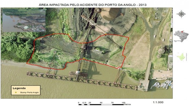
http://www.portalamazonia.com.br/editoria/cidades/ma-estrutura-do-pier-da-anglo-american-causou-acidente-no-amapa/
And an aerial image of the site after the accident:
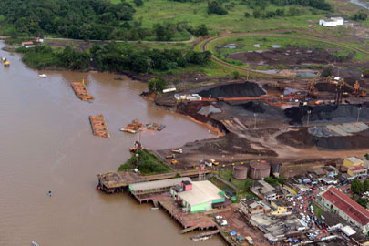
http://www.portalamazonia.com.br/editoria/cidades/ma-estrutura-do-pier-da-anglo-american-causou-acidente-no-amapa/
A translation of the text on that site is as follows:
The main hypothesis about the cause of the accident in the Port city of Santana, Amapá, last Thursday (28), has been proposed. A technical report, released on Monday pointed out that the lack of proper structure at the base of the pier owned by the Anglo American company triggered a landslide in the area that was part of the floating port on the banks of the Amazon River. The accident killed six people working on the site.
The official explanation has been proposed by the technical staff of the Institute of the Environment and Spatial Planning of the State of Amapá (Imap). The cause of the accident was the intense movement of trucks and cranes loaded with tons of iron ore at the company pier. At the time of the accident, there were half a million tonnes of iron ore at the pier. “We note that this is an impact point. The observations lead to several signs of fragility in the soil that could not stand the pressure of intense movement associated with the company activities, “explained the director of Imap, Mauricio Souza.
There is a reasonably recent image of the loading point on this website:
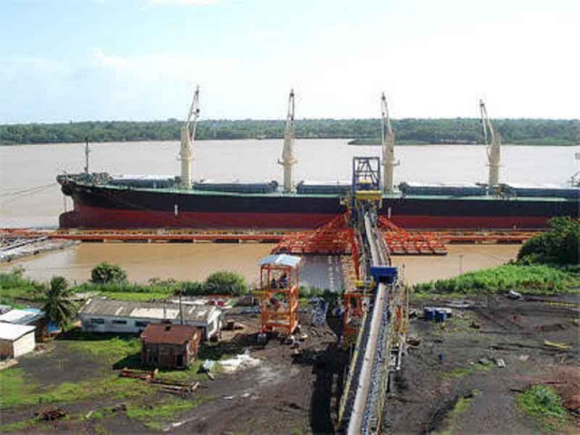
http://santanadoamapa.blogspot.com.br/2012/08/o-departamento-nacional-de-producao.html
So, this appears to be a large-scale failure of the riverbank associated with loading caused by the weight of iron ore that was being stored. This collapse generated a localised wave that destroyed the pier, killing the three victims. Interestingly, the wave was caught on video on a nearby small port. This can be seen below. The video is long; the action occurs at about 15 minutes from the start of the film.
2 April 2013
Updated: The strange case of the sinking pontoon in Brazil
NB: now corrected with images of the site.
Over the weekend there has been a number of news stories about a peculiar event in Brazil on Thursday night. This news story from the BBC is typical:
A mining company in Brazil says an inquiry has begun into the cause of the collapse and sinking of a floating port on the Amazon river, in Amapa state. Rescue operations are under way to locate six workers who went missing. An official blamed a big wave that allegedly washed over the banks of the Amazon, dragging with it cranes, lorries and people … “There was a wave that washed over the banks of Santana, even reaching the island of Santana. This wave also hit the company’s port,” Paulo Oliveira, a spokesman for Anglo Ferrous told the local channel TV Amapa. Other witnesses, however, told reporters that the quick and powerful water surge was a consequence of the landslide and the sinking of the floating port facilities, which were used for loading ships with iron ore.
In a statement, Anglo-American said the causes of the collapse were being investigated. “An iron ore vessel was docked at the pier for loading at the time and was hit by flood waters. Flood waters also dragged vehicles and shipping equipment into the river,” the company said. Authorities avoided pointing fingers before the experts complete their tasks. “Right now, it would be inappropriate to try and find a culprit, but after a detailed survey, we will get to understand the causes and be able to attribute responsibilities,” the state governor of Amapa, Camilo Capiberibe, said.
The same report also has this image of the site:
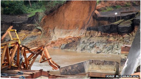
http://www.bbc.co.uk/news/world-latin-america-21971513
Other reports suggest that a landslide occurred. For example, Fox News report:
Details on the exact cause of the accident, which occurred shortly after midnight at the port of Santana and is being investigated, weren’t immediately known. Firefighters from Brazil’s northern Amapa state said a stretch of riverbank roughly 200 meters long collapsed, causing a pier to sink into the water … “The water is very murky and about 25 meters deep, which is making the search difficult,” a firefighter said. He added that heavy rains in recent days suggest a possible landslide. On the other hand, Anglo-American said in a statement that “initial information attributes the accident to an unusually large mass of water moving along the river, as other ports located in the region were also affected.” A ship captain present at the port initially described the incident as a tsunami, a theory that was later discarded. One vessel loading iron ore at the pier was damaged, a shipping source said.
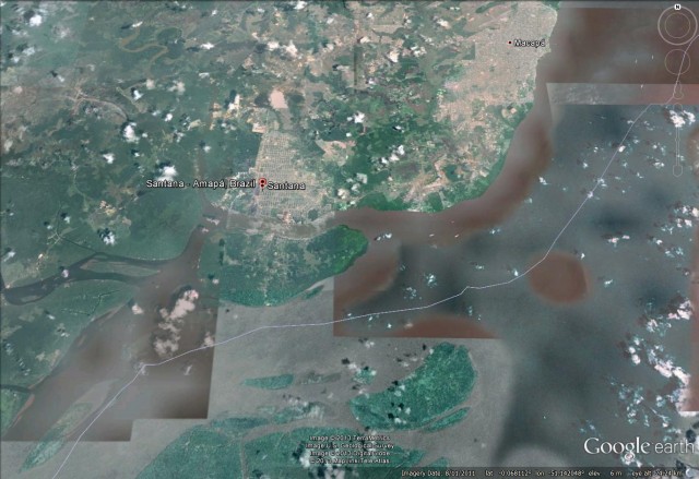
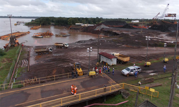
http://pedlowski.blogspot.co.uk/
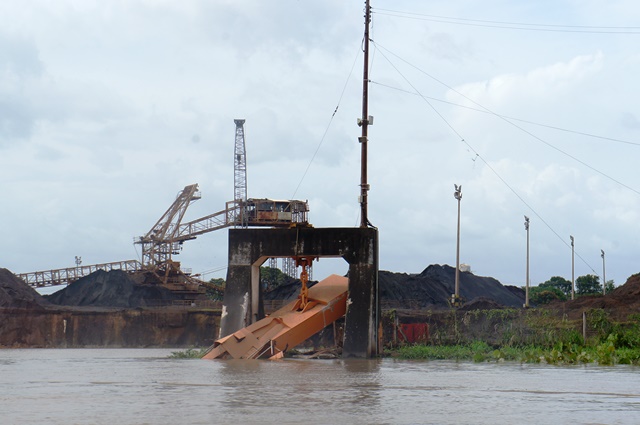
http://www.alcinea.com/geral/anglo-suspende-atividades-em-santana
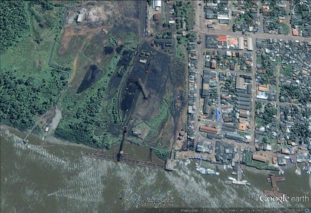
All of the evidence suggests to me a failure of the land on the river bank, which then generated the wave that was observed by the ship’s captain. Interesting, if so his observation of a tsunami is correct, albeit a very localised one. These sort of collapse events can be very dramatic, as an earlier (and rather larger) event on a Brazil dockside (in Manaus in 2010) demonstrated:
30 March 2013
News of the Tibet gold mine landslide
First, many thanks to Adrian Moon for his help in putting together this post.
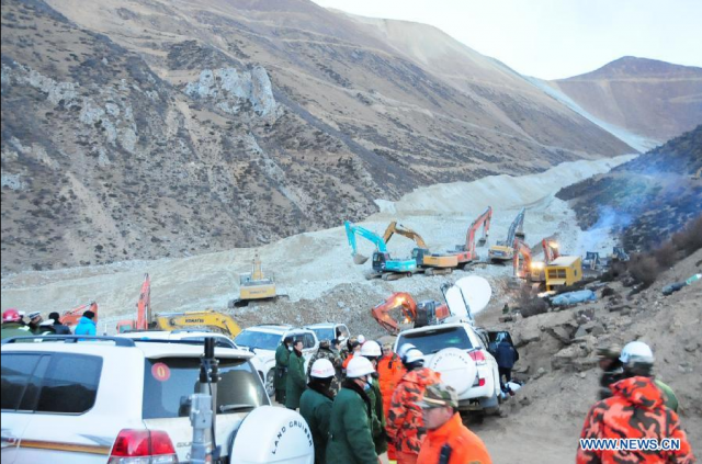
Xinhua has continued to run various stories about the catastrophic landslide at a gold mine in Medrogungkar, Tibet yesterday. The sad headline news is that no survivors have been recovered, despite the attention of a large number of rescuers. Xinhua has also released two tranches of images of the site (here and here), most of which focus on the rescuers in heroic poses. However, a small number give a better idea of the scale of this event, of which this is by far the best:
http://news.xinhuanet.com/english/photo/2013-03/30/c_132273063_3.htm
Assuming that the source of the landslide is the apparently fresh material on the slope on the right side of the image, this is clearly a very long run out landslide. The fresh material in the valley is undoubtedly the landslide deposit – it appears that this was a highly energetic, rapid, flow-type event. It would be really interesting to see an image of the source area, but even from this image it is clear that this is not a typical quarry landslide. The enormous scale of the landslide is shown in this Sky News video:
http://www.youtube.com/watch?v=9Yf-BpKniqs
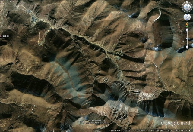
The most likely location of the landslide, although this is not confirmed, 29.681 degrees E, 91.904 degrees North. This is the Jiama mine (which elsewhere is sometimes called the Jiama Copper Mine). If so, there is more information about the mine here. Certainly the satellite image from Google Earth is consistent with the images from Xinhua:
 .
.
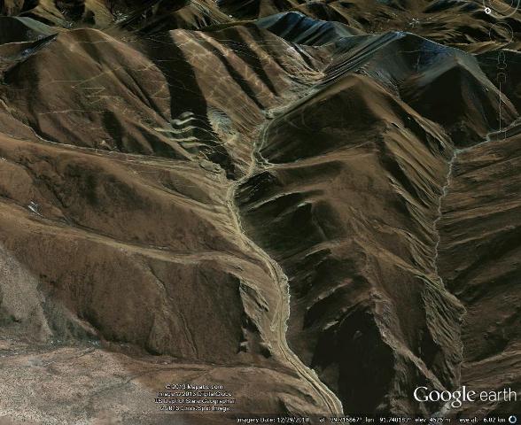
A Google Earth perspective view demonstrates how a very large-scale slope failure could become channelised in this very narrow, steep valley:
.
In such a large landslide recovering the victims is a monumental task.
29 March 2013
First reports of a massive landslide in Tibet – 83 people reported to have been killed
Xinhua is reporting that a landslide occurred at 6 am local time at a gold mine in Maizhokunggar County, which is in Chinese-controlled Tibet. The landslide is reported to be very large – some reports say 4 square kilometres, whilst a slightly more credible report suggests that the deposit is 2 km in length and 50 metres wide, with a volume of 2 million cubic metres. Unfortunately the landslide appears to have buried a set of workers’ huts, with 83 people reported missing. The likelihood of them surviving such an event is extremely low.
There are images in some of the news reports (e.g. here), but it is far from clear to me that these actually depict the incident in question. Some look far too small. Images are likely to appear in the next 24 hours though.
This event is sufficiently large to have attracted the attention of the new Chinese Premier and President, who have urged both a rapid rescue effort and a full investigation of what went wrong.
The Chinese mining industry has a wretched track record when it come to landslides, as many posts on this blog (e.g. here, here, here and here) testify. Mining is dangerous everywhere, but in China the levels of loss are truly terrifying.
28 March 2013
A new landslide on Whidbey Island
Many thanks to the various people, too numerous to mention, who highlighted this event to me
Whidbey Island in Washington State in NW USA is a well-known landslide site, and indeed has appeared on this blog before. Yesterday a new landslide developed on a coastal cliff, destroying one house and threatening a further 30 or so. This appears to be the site before the landslide, as shown on Google Earth:

.
There is a really fantastic set of images on the Seattle Times blog, taken from both the air and the ground. This one gives a really good view of the landslide itself:

| http://seattletimes.com/html/photogalleries/localnews2020650059/2.html (c) Ted Warren / AP |
An interesting aspect of this is to compare the state of the top of the cliff with that after the landslide. This is a post landslide view, also from the Seattle Times:

| http://seattletimes.com/html/photogalleries/localnews2020650059/2.html (c) Ted Warren / AP |
This is a similar view from the Google Earth imagery:

.
The length of cliff top lost is actually rather small given the size of the landslide. This, in this case most of the movement is in material already at the bottom of the cliff rather than a large detachment from the top. This may well explain why there are no obvious cracks on the Google Earth imagery.
23 March 2013
The role of joints in controlling rockfalls
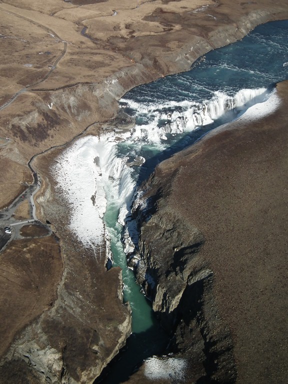
In Iceland we flew over the spectacular Gullfoss waterfall. This is a wonderful site, although it was pretty cold, as the frozen spray around the waterfall demonstrates:
 .
.
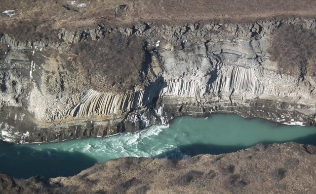
Just downstream is an amazing outcrop of columnar basalt in the gorge wall . This cannot be easily viewed from the ground (it is on the wrong side), but from the air one gets a pretty good view:
 .
.
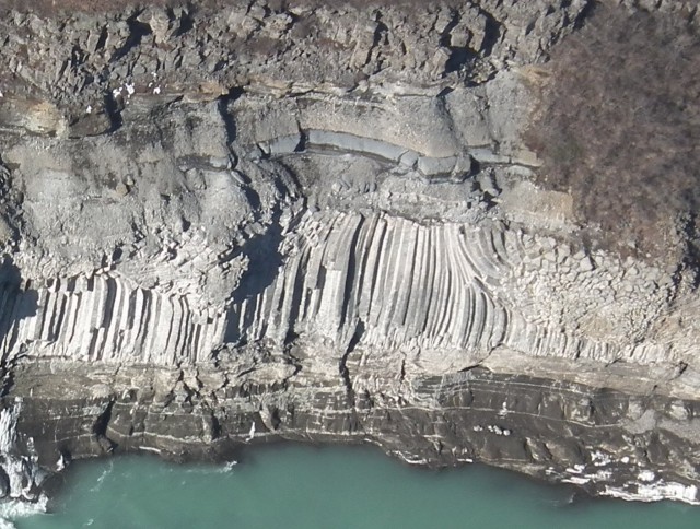
As well as being a genuinely increadible rock outcrop, this is a very nice illustration of the control that joints play in controlling rockfalls. Let’s zoom into a part of the image above:
 .
.
To the right of the columns is a section of heavily-jointed rock. Here (relatively) small pieces can detach – and indeed below this section of cliff there are some blocks sitting on a ledge. The result is a face that is comparatively planar. The columnar basalt.itself yields rockfalls much less easily. To detach, a block needs to topple, or to fracture, both of which are quite hard to achieve. The result is a rockface that, at least along a horizontal line, has a great deal more relief. Below the basalt is an almost unjointed section – this probably erodes primarily through abrasion of debris carried by the river when it is in flood. Leaving a smooth but undulating, surface.
It is for this reason that we often consider that the discontinuities (joints) are more important than the rock itself when trying to understand potential rockfalls.
22 March 2013
A very important new paper – detecting large landslides using seismic data
 A paper was published today in the journal Science by Goran Ekstrom and Colin Stark in which they report on the use of the global seismic network to detect very large landslides in remote areas. Unfortunately the paper (Ekstrom and Stark 2013) is behind a pay wall, so I cannot provide a link to the actual text. Science have put out a press release about the work, and there are a couple of other news stories about it (here and here for example). For those that have access to the article, some of the landslides that they describe will be familiar. You will remember that last summer Colin provided data from his ongoing work with Goran that allowed us to unravel the mystery of the Seti River landslide in Nepal, and subsequently two rock avalanches in Alaska.
I was lucky enough to be asked to write the “perspectives” article (Petley 2013) that accompanies Ekstrom and Stark (2013), and this has also now been published in Science, so I have been lucky enough to read this paper ahead of its publication. I think that Goran and Colin have produced a really important piece of work. The essence is simple – very large landslides radiate seismic energy that is detectable using global seismic monitoring instruments. This of course was already known. What is novel about this work is that the authors have used an analytical model to analyse the seismic data to generate information about the landslide. At the moment this analysis uses a series of quite simple assumptions – I suspect that over the next few years this will become more sophisticated – but nonetheless it is very revealing. In particular it allows the generation of data on the size, direction of movement, travel distance and velocity of the landslide, as well as giving an indication of the location and of course the timing of the event.
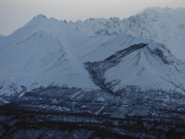
So, to my mind this is important for three reasons. First, we now have a technique that allows large landslides to be automatically detected. Given that these tend to occur in very remote areas, they often go unreported. In fact, in the newspapers today there is a nice example of this (and thanks to Marten Geertsema for making me aware of this one). Alaska Public Media today is carrying the story of a large landslide near to the Matanuska Glacier “sometime in February”. They have this picture, which was taken by staff at Sheep Mountain Lodge:
 .
.
The ability to build a catalogue of these events is very important; at last we will be able to work out just how frequent these events are.
Secondly, and perhaps most interestingly, the technique provides for the first time a systematic dataset that allows the dynamics of these landslides to be quantified. At the moment we do not understand how very large landslides move – they seem to go far further than one would normally expect, so it has been hypothesised that some mechanism acts that permits very long runout distances. We do not know what that mechanism might be, and indeed some argue that no such special mechanism is necessary. Being able to analyse the quantitative data that these landslides provide via the seismic network might help us to answer this question.
And thirdly, the technique allows us to validate our field mapping of landslides. The paper gives the example of a large rock avalanche detected using their technique in the Siachen area of northern Pakistan. Mappig of this landslide from the satellite imagery would indicate that it occurred in one or two large events. The seismic data indicates that it occurred as a much large number of discrete landslides over a few days. Knowing that will allow us to improve our field mapping, which in turn means that our analysis of the remains of ancient landslide deposits, and those triggered by earthquakes, will improve.
So, overall, this is probably the most important landslide paper of the last five years, and I am sure it will generate considerable discussion. I welcome your comments.
References
Ekstrom, G., & Stark, C. (2013). Simple Scaling of Catastrophic Landslide Dynamics Science, 339 (6126), 1416-1419 DOI: 10.1126/science.1232887
Petley, D. (2013). Characterizing Giant Landslides Science, 339 (6126), 1395-1396 DOI: 10.1126/science.1236165
21 March 2013
Helicopter images of the Mid-Atlantic ridge in Iceland
I am in the middle of a somewhat chaotic week of travel – Durham, London, Iceland, Durham, London, Padua, London, Brussels, London, Durham, all in a week. However, this started with an amazing weekend, in which Michele and I went to Iceland to celebrate a significant birthday. On the day that we arrived, in glorious weather, we chartered a helicopter to fly over the Mid-Atlantic rift and other sites on the so-called Golden Circle. This is a somewhat expensive thing to do, but the views were quite unbelievable and it was a once in a lifetime experience. I thought I’d reproduce a few of the images here:
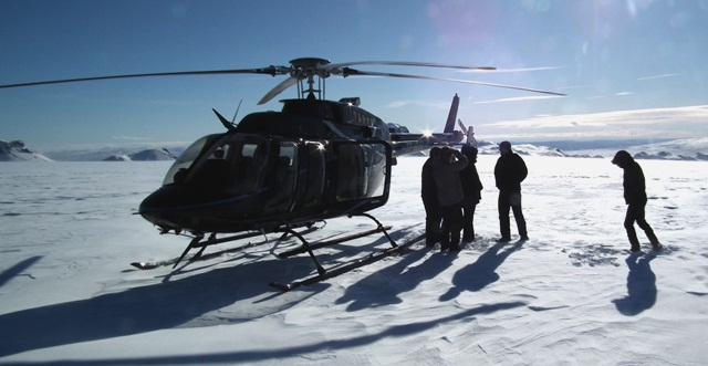
So first of all, this was our chariot – a Bell 407. You will see that we also made a stop on a glacier en route:
 .
.
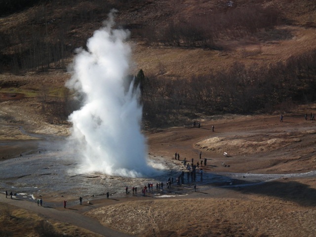
We flew over, and indeed stopped to look around, Geysir, and we were lucky enough to be flying over the Strokkur geyser fas she blew:
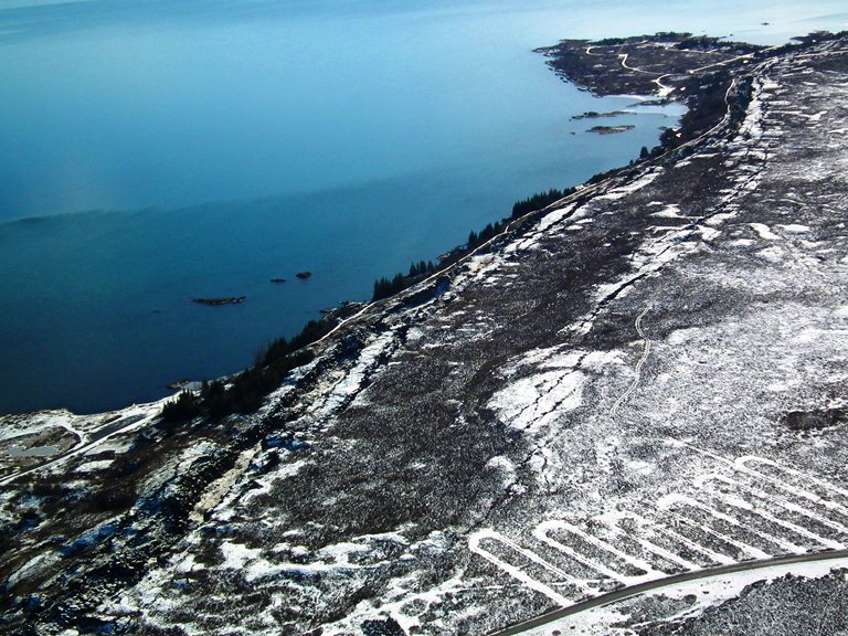
We then flew over the rift itself at Pingvellir. This a very impressive sight on the ground, but from the air you get a much better impression of the ways in which the rifting processes are operating:
 .
.
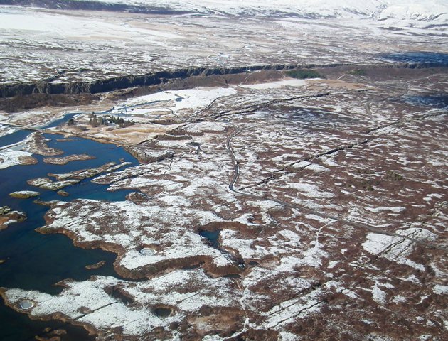
The scarp on the edge of the lake is the main margin of the rift, but note the multiple fractures on the land side of the scarp. This is much more evident a little further to the north, where it is possible to see multiple arrays of tension cracks running parallel to the main scarp:
 .
.
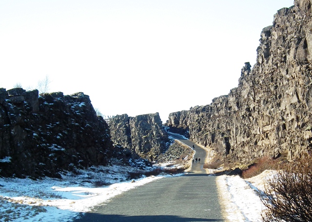
The rift is also fantastic on the ground:
 .
.
Iceland is an amazing place. Go there if you have a chance. In answer to a couple of queries, if you want to repeat our experience we flew with Heli.is, who were genuinely excellent. I would recommend them – for the record I have no links with them at all.
14 March 2013
Managing landslide hazard – an example from Franz Josef in New Zealand
Nicolas Barth at the Department of Geology at the University of Otago has a paper (Barth 2013) in the journal Landslides about rock avalanches in New Zealand triggered by the Alpine Fault. The main topic of the paper is a fantastic ancient landslide known as the Cascade Rock Avalanche. This image is taken from his website, showing the landslide in all of its glory:
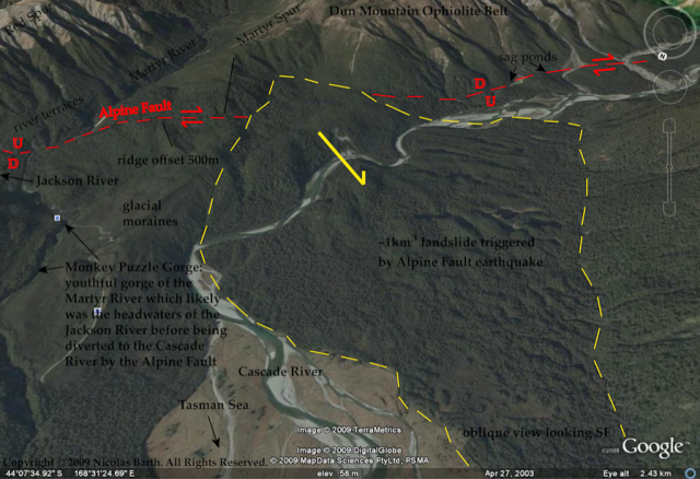 .
.
His treatment of this landslide is really interesting, and worthy of a blog post all of its own, but for me the most eye-catching element is a short section at the end of the paper in which he examines another potential large landslide at Franz Josef. This is an important tourist destination in South Island, the jumping off point for tours to the Franz Josef glacier. Although the town has only 330 permanent residents, this number increases to over 2000 in peak tourist periods. Barth (2103) notes that:
“Of particular note is the hillside above Franz Josef township, c. 150 km northeast of the Cascade Valley, which displays several of the structural characteristics identified at the Cascade and RT rock avalanches. At 700 m elevation, there is a linear trough-like break in slope with a c. 100 m-high scarp-like surface above and a bulging hillslope below. The Alpine Fault passes through the township and dips moderately beneath the hillside…The lateral distance to the town from the linear trough is 1,300 or 400 m measured from the base of the hill to the town. The mass of rock that could potentially fail at Franz Josef has comparable dimensions to the source of the Mt. Wilberg rock avalanche…a comparable event at Franz Josef would completely devastate the town.”
The slope in question is clearly shown in Google Earth:
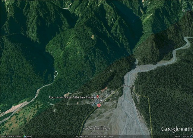 .
.
The small township at the foot of the slope is clear on the image above. The area of concern is the forested slope behind the town, extending up to the ridge crest. The strange topography towards the top of the slope is likely to be deformation caused by creep of the slope.
I was lucky enough to visit the town in September with colleagues. We spent some time mulling over the slope. From the ground it is much easier to get an impression of the nature of the slope and the rather unusual, bulging, geometry:
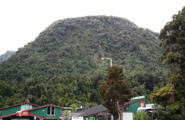 .
.
The reason that it causes concern is this depression at the top of the slope (highlighted with arrows below), which probably indicates that the slope has been creeping:
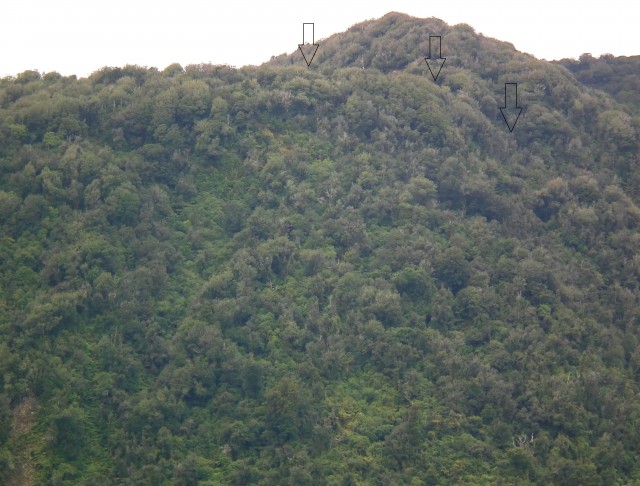 .
.
It is important not to blow the hazard here out of proportion – the slope has probably looked like this for hundreds and maybe even thousands of years, and it may continue to do so for thousands more. The likely trigger event for a collapse, should one ever occur, is an Alpine Fault earthquake (and given that the fault runs straight through the town, this would be a challenging event anyway). However, it is impossible to say whether the key trigger might be the next earthquake, one of the next ten earthquakes, or indeed whether it may never fail.
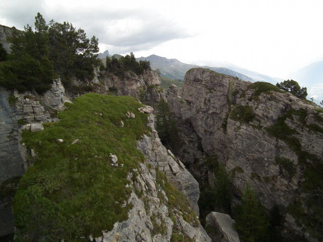
This rather neatly highlights the problems of assessing hazards from large, steep slopes in high mountain areas. In the Alps many slopes also show signs of deformation, many of which look quite alarming. This is an example from Switzerland:
 .
.
Such slopes in the Alps very rarely fall down. Of course at Franz Josef the additional factor is the presence of a major active fault, so in my view it would be sensible to investigate the slope properly in order to assess the risk (though this is a far from easy task given the topography and vegetation).
In the meantime of course there is no reason to worry unduly about the slope, and there is certainly no reason not to visit the town, which is a well worth a trip. And do read the paper – it is excellent!
Reference
Barth, N. (2013). The Cascade rock avalanche: implications of a very large Alpine Fault-triggered failure, New Zealand Landslides DOI: 10.1007/s10346-013-0389-1
13 March 2013
LARAM School 2013 – the best possible training on landslide risk assessment and mitigation
LARAM – the International School on ”LAndslide Risk Assessment and Mitigation” (for PhD students and Young Doctors) is an annual event that provides training for early career researchers working in the fields of Civil Engineering, Environmental Engineering, Engineering Geology or with a similar Engineering background. It is held in Salerno in September each year. Several of my PhD students and post-docs have attended – without exception they have found it to be an invaluable experience.
The call has just gone out for the course in 2013., which will be held from 2nd to 14th September. Details are here – do apply if you qualify. There are places for 40 PhD students and 20 recently qualified post-doctoral researchers.
 Dave Petley is the Vice-Chancellor of the University of Hull in the United Kingdom. His blog provides commentary and analysis of landslide events occurring worldwide, including the landslides themselves, latest research, and conferences and meetings.
Recent Comments