
15 August 2014
Continuing landslide turmoil in Nepal
The Sunkoshi landslide in Nepal – an update
Landslides continue to cause major disruption in Nepal as the summer monsoon intensifies. At Sunkoshi, the major river-blocking landslide continues to confound the attempts by the army to draw down the lake, despite the presence of heavy machinery and now over 50 controlled blasts by the Nepal Army. Indeed, in the heavy rainfall of the last few days reports suggest that the lake level has risen by 50 cm.
I think that there is little doubt that the Nepal Army has been working very hard on this problem, and deploying resources extensively. However, the communications side of the work has gone less well, with repeated statements that the lake level is falling and/or that the problem would be solved within a day or two. This has been proven to be erroneous and overly-optimistic. Unfortunately, the press have taken such statements at face-value, which in turn has generated a huge backlash when the problem could not be resolved. eKantipur today has an article entitled “Shame On You!”, which is strongly critical of the government’s efforts in dealing with all aspects of the landslide. As Nepal moves towards the Desain holiday, which is important for shopping, and imports from the north remain impossible, these pressures are going to rapidly grow.
The bottom line is that there is now a need to both implement a proper communications plan, which should emphasise the need to view this as a long term project (whilst recognising that a rapid breach event can still occur), and to call for expert assistance, in particular from China, where there is considerable expertise in managing these issues. Based on experience elsewhere I suspect that there will be a need to either block the existing channel to blast the base (not an option during the monsoon, and probably not in the dry season either because the dam has so little freeboard across the entire width) or to build a new channel from the foot of the dam upwards. This is a major project that will take some time, assuming that the dam does not breach first. As usual the lack of information about the structure of the dam is a major issue, meaning that its behaviour is unpredictable.
Heavy rainfall across Nepal and N. India causes high levels of loss
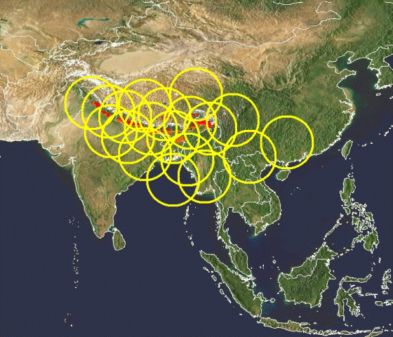
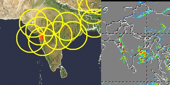
Meanwhile, very heavy monsoon rainfall across Nepal and northern India over the last few days has generated high levels of losses from landslides and floods. For example, Republica is reporting 53 people killed and 75 missing in Nepal, although this figure may change considerably as news filters through. Chisapani in West Nepal reportedly received 545 mm of precipitation in 24 hours. At least 23 people have been killed in northern India too. TRMM highlights the areas likely to have been affected by the landslides, which extends along much of the Himalayan Arc:
12 August 2014
The Eaglepointe Landslide in Salt Lake City, Utah
The Eaglepointe landslide
One of the many landslide events in the last few days was a slide in the Eaglepointe subdivision in Salt Lake City in Utah. The development of this landslide was brilliantly caught on a time-lapse video by KUTV reported Holly Menino and 2News photographer Mike Stephen:
.
Jeff Moore of the University of Utah has very helpfully put together the following incredibly useful briefing on the Eaglepointe landslide:
- On Tuesday morning Aug 5, around 6 am, a large landslide underwent rapid and sustained failure, displacing some tens of meters over a period of minutes.
- One house was destroyed and three others imminently threatened. A nearby gas pipeline was undamaged.
- Movement had initiated at least four months prior back in April (our wet season), by some accounts back in fall 2013.
- In the week before the slide, large tension cracks had been growing at the crest of the slope, and the toe area was bulging creating some distress to adjacent properties.
- The developer hired geotechnical consultants to install inclinometers at the crest, and homeowners were diligently observant of the slope.
- Residents had received a letter indicating that there was a slide and to be prepared, but most seem to have already known due to the obvious signs of ground distress.
- During the morning of the failure, rolling boulders from the toe woke one of the 12 residents in the destroyed home, who then woke the rest of his extended family and everyone evacuated from the house before it collapsed.
- Movement later slowed but the scarp and slide mass threaten more homes.
- A heavy monsoon rain storm the previous evening is the ascribed trigger of ultimate movement, although slow displacement had been ongoing for months.
- My preliminary volume estimate of the slide is ~300,000 m3, based on the aerial extent and an assumed average depth of 10 m.
- The slide mass consists of sands and gravels of the Lake Bonneville highstand, overlain atop Tertiary volcanic tuff – the latter is a notorious material for landslides in the northern Utah, the so-called Norwood Tuff. It weathers to swelling, water-sensitive clays. The condition or depth of the sliding surface is however, not known at this time.
- Another slide just 1 km away in similar stratigraphy (named Springhill) destroyed several homes over an extended period in 1998 and during later wet years. Yet another slide in the same geology is progressively destroying several residential lots in nearby City Creek.
- The development was a gravel quarry until the late 1990’s, and the area that slid was the highwall or maximum extent of quarrying. It had been graded at 2:1 (~25 degrees). The houses threatened were built in the mid-2000’s. New development is currently underway at the crest of the slope that failed, including new roads and several new homes.
- Geotech reports used by the developer and city to permit the previous and new construction deemed the slope globally stable. These can be downloaded and freely reviewed here: http://nslcity.org/index.aspx?NID=331
- Some smaller sluffs and slides had been observed in previous years especially around the base of the slope where small cut-backs had been made.
- Location: https://www.google.com/maps/@40.8274081,-111.9022917,295m/data=!3m1!1e3 – to the north of the slope you can see the covered tennis courts and home immediately west that sustained the most damage, as well as some clearing for development at the crest of the slope (south).
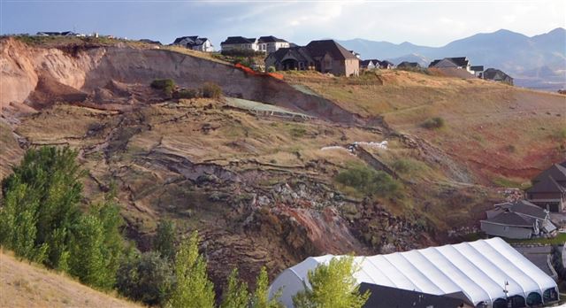
Standard.net has a great gallery of images of the landslide. This image from that set shows the state of the eaglepointe landslide site now:
http://www.standard.net/Local/2014/08/06/North-Salt-Lake-residents-blame-city-for-landslide.html
.
Given the history of the site I think that it is unlikely that the Eaglepointe landslide can be considered to be a natural event. However, it is not clear to me who, if anyone, might be to blame.
7 August 2014
[Bhote Kosi] Sunkoshi (corrected) landslide in Nepal – an update
The [Bhote Kosi landslide] Sunkoshi landslide
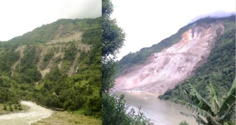
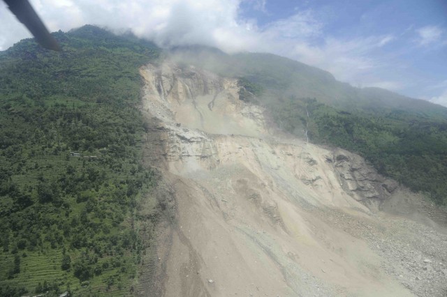
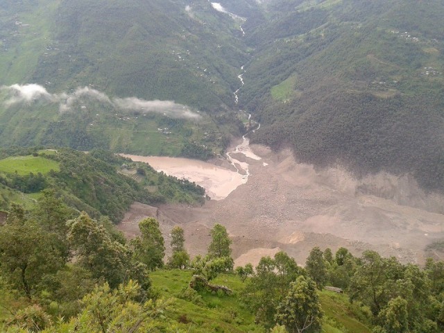
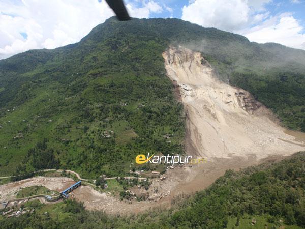
[The Bhote Kosi landslide now seems to be the accepted name for the landslide that I have been calling Sunkoshi, so I am adopting the local name. So let’s start by looking at what we know about the Bhote Kosi landslide]. [EDIT: The comment below by Ranjan Dahal suggests that the correct term is Sunkoshi, so I am reverting to this terminology] Colin Stark, Goran Ekstrom and Clement Hibert have been looking at the seismic signals generated by the earthquake – it was recorded as an Msw=4.7 (approx.) event. The signal suggests that the landslide occurred at 20:51:44 UTC on 1st August (which is 02:36:44 on 2nd August local time). The landslide force inversion suggests that the landslide mass was about 13.5 million tonnes, which corresponds to a volume of about 5.5 million cubic metres, give or take a bit. This image, kindly provided by Kunda Dixit but taken by Tuk Lal Adhikari and used with permission, shows the [Bhote Kosi landslide] Sunkoshi landslide and the deposit:
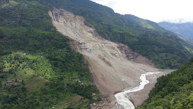
Image courtesy and copyright of Tuk Lal Adhikari
.
Based on this it appears that the [Bhote Khosi landslide] Sunkoshi landslide started as a rockslope failure in the upper reaches – there may be a rotational component, although this is hard to tell, which then triggered a deep failure in the lower section (below the bedrock bench). It is interesting to note the freshly fractured rock in the upper scarp and the flow of water over the face in this region. Note that the landslide spread laterally by some distance to generate a broad, low angled landslide mass.
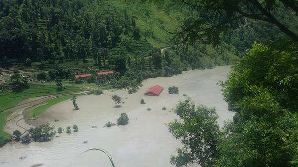
The lake level at the [Bhote Kosi landslide] Sunkoshi landslide
Clearly in Nepal there is a great deal of concern about the barrier lake that has formed, both because of the potential for a breach flood and because the lake has closed the Araniko Highway to Tibet. The image below, also by Tuk Lal Adhikari, shows the blockage and the channel:
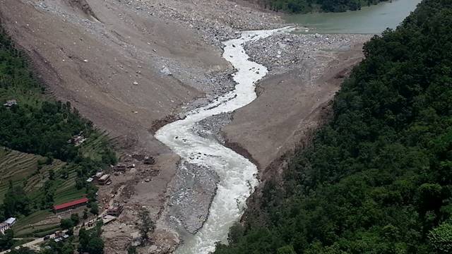
Imagy courtsey and copyright of Tuk Lal Adhikari
.
A few things to note here:
- The channel has a reasonably low gradient, reflecting the broad, low gradient landslide deposit. This means that the chances of a sudden breach event are lower, though cannot be ruled out. A sudden large inflow into the lake would be dangerous;
- The channel does not seem to have incised significantly (reflecting the bedrock nature of the landslide), but has eroded laterally through the weaker surface materials;
- The constraint on the channel is the very narrow section at the dam crest, which has a very rocky surface form.
- If a road is to be constructed over the landslide then it will be either pushed against the foot of the cliff (very hazardous as rockfall activity will continue for a long time), or it will have to cross the river twice, or the river will have to be moved. None of these options are straightforward.
- There is no sign from this image that the lake level has decreased substantially.
So at present the landslide appears to be in a state of status quo. Ripendra Awal of Prairie View A&M University in Texas has taken a look at the gauging station data for Baharabise (4.2 km upstream of the landslide) and Pachuwarghat (38 km downstream) for the period since the landslide. This data is available online here. Ripendra has demonstrated that before the landslide the flows at the two stations were highly correlated – in other words if you know the flow at one you can, using a simple equation, determine the flow at the other (there is a three hour lag between the two stations that needs to be built into this). Ripendra has then generated a graph of the flows at the two stations during the period of the landslide crisis. He sent me the graph yesterday – I have updated it with today’s data and reproduce it below:
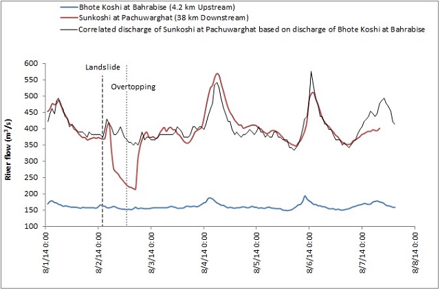
Courtesy of Ripendra Awal, updated by the author
.
The blue line is in effect the inflow of water to the lake, the red is the discharge downstream (much higher because there are other rivers feeding into the Sunkhosi downstream of the dam). The black line is the expected discharge for Sunkoshi as determined from the dam inflow, based on the relationship before the landslide. So, three hours after the dam formed (shown on the graph as the first vertical line) the flow in the Sunkoshi dropped as water was impounded by the blockage. A few hours later the water overtopped, and the flow came back to the expected level.
The difference between the red and black lines thereafter is an indication of the behaviour of the lake trapped behind the [Bhote Kosi landslide] Sunkoshi landslide. If the red line is above the black one then the lake might be draining, if it is below then it might be filling (i.e. the water level is rising). For most of the period since the overtopping the two lines have been very close, suggesting little change in lake level. On 4th and 5th August the red line is a little above the black, so the lake might have been emptying by a small amount, which is consistent with media reports. Yesterday the two were in close lockstep, suggesting little change, which is also consistent with reports. Strangely, today the red is below the black, which might mean that the lake is filling. Don’t read too much into this though – it could also be that the data are not yet reliable or that the Sunkoshi has received a big flow of water from another source.
The key conclusion is that the lake level is not falling appreciably. I would think that this is because the gradient of the landslide body is so low that the channel is not eroding downwards. This was also the case at Attabad. This might suggest that to clear the Bhote Kosi landslide blockage large-scale blasting and/or excavation is going to be needed, but undertaken very carefully of course to avoid a rapid breach. And in turn this suggests that the army have a long and difficult task ahead of them. Meanwhile the road to Tibet remains closed and will be hard to reopen until the lake level is drawn down, and people upstream face difficulties travelling.
The [Bhote Kosi landslide] Sunkoshi landslide represents a very major challenge for Nepal. Unfortunately this is not going to be easy to fix or to manage.
6 August 2014
Yunnan earthquake: images of the valley blocking landslides
Yunnan earthquake
There is so much going on in terms of landslides at the moment that it is hard to know where to start! However, a key issue is the valley-blocking landslides and associated “quake lakes” triggered by the Yunnan earthquake of a few days ago. Yesterday, Xinhua posted a story about the impacts of landslides within the Yunnan earthquake zone that starts to shed some light on the issue:
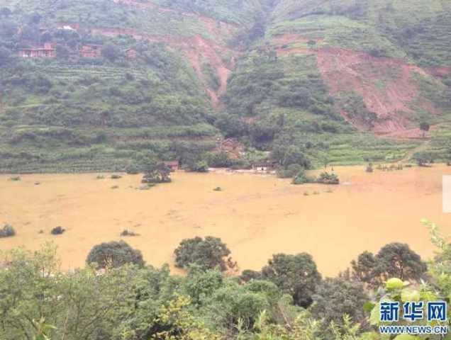
Landslides have blocked roads leading to Longtoushan Township in Ludian County, epicenter of Sunday’s tremor, which killed at least 410 people and injured more than 2,300 others. A road leading to a large barrier lake on Niulan River was made passable after 38 hours of repairs by an armed police squad. Repair work is underway on three other roads in the quake zone.
As of 6 p.m. Tuesday, accumulated water volume of the barrier lake had reached 49.6 million cubic meters, and the water level is increasing at a speed of 16 cm per hour, said Sun Huaikun, a technical specialist in charge of the barrier lake response. Sun told a press conference late Tuesday that 4,200 residents living on the lower reaches of the Niulan River had been evacuated. A reservoir, located on the upper reaches, is required to intercept river water and reduce pressure on the barrier lake.
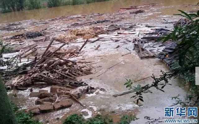
Barrier lakes, formed by landslides blocking rivers, are a recurrent threat to the lives of victims and rescuers alike. A 24-year-old border policeman is missing after he was hit by a falling rock as he attempted to swim a barrier lake in search of survivors. More than 60 soldiers were trapped by a sudden flood from a barrier lake Tuesday afternoon and were rescued by another team of armed police.
The most useful information though has come via tweet from Armand Vervaeck:
@davepetley – #Landslide #lake #earthquake Yunnan #China – Guess this page will be of interest to you! – http://t.co/rCpISFLqwP
— Armand Vervaeck (@ArmandVervaeck) August 5, 2014
.
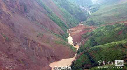
The link is to a web page of the National Administration of Surveying, Mapping and Geoinformation, which provides a series of satellite images of landslides triggered by the earthquake. One of the images is this one of a valley blocking landslide:
 .
.
This appears to be a very large landslide dam that still has the potential to impound a great deal more water. The slide appears to have been quite mobile, showing signs of flowing down the valley (towards the left on the above image). If so, this should mean that the downslope gradient is less steep, which will reduce the chance of a catastrophic breach event. The landslide and lake have destroyed a large amount of infrastructure, including what appears to be a hydroelectric barrage and a bridge, judging by this before-and-after image pair from the same site:
 .
.
The site of this landslide is at 27.036 N, 103.409 E if you want to take a look on Google Earth. This is a perspective view of the landslide site:
 .
.
About 22 km downstream there appears to be a very large dam and long reservoir. This will catch the flood if a catastrophic breach occurs, so long as the water level can be drawn down in time. I would imagine that this is a very pressing imperative at the site at present. The timing of the earthquake, right in the middle of the monsoon, means that landslide occurrence will have been higher than would have been the case in the dry season and the rate of filling of the barrier lakes will also be high.
5 August 2014
Valley-blocking landslides: latest from Sunkoshi and Yunnan, and a brief update on the Malin landslide in India
At present there are two sets of major valley blocking landslides threatening communities downstream simultaneously, one in Sunkoshi in Nepal and one in Yunnan Province of China:
Sunkoshi landslide dam update
After a major effort to recover bodies, the number now known to have been killed in the Sunkoshi landslide in Sindhulpalchok is now known to have reached 33, but about 120 remain missing. News reports suggest that 57 houses were lost in the landslide, whilst a further 18 have been inundated by the lake. Whilst news reports yesterday suggested that the level of the lake had fallen by as much as 4 m, this has now been corrected to about 50 cm, and there are suggestions that the level may have risen again due to recent heavy rainfall. The Nepalese army are blasting the crest of the dam to try to increase the rate of flow.
So now the situation appears to be similar to that of the Attabad landslide dam in Pakistan. The threat of an outburst has not gone away, although the immediate crisis has reduced. The great challenge now is to know how to manage the hazard. There are reports that people are starting to return to their houses in threatened areas – this is understandable – plus of course the blockage of the road to Tibet is deeply problematic for cross-border trade. The key will be the evolution of the spillway over the dam. There are some suggestions that there are now two or three channels, which in some ways may not be helpful. The ideal solution is for the floor of the channel to erode down slowly, releasing all of the water over a long period of time. The worst case scenario is very rapid erosion, causing a dramatic flood. But with three channels the amount of erosion may well be limited, which means that the dam may stay intact into the future. This will prevent the road from being rebuilt and will leave the hazard in the landscape.
But dealing with these problems is immensely difficult, and once again the Nepalese authorities deserve a great deal of credit for their proactive approach to this disaster.
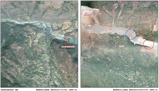
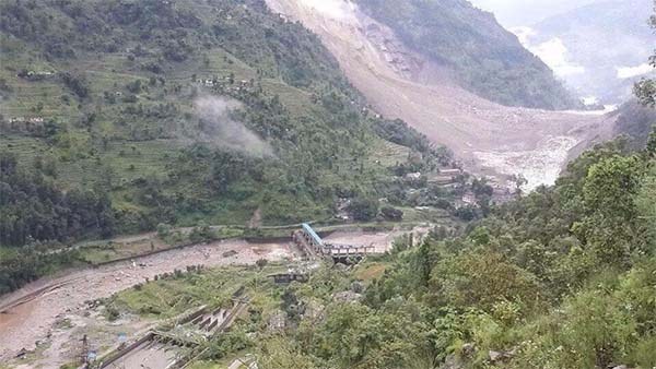
Meanwhile, ICIMOD have released a report on the landslide that makes interesting reading. They tweeted this before-and-after image of the slope:
.
Yunnan valley-blocking landslides
Usually I would expect that the Nepal government would be able to turn to the expert Chinese teams who specialise in valley-blocking landslides for help, but the timing is deeply unfortunate in that the Yunnan earthquake of two days ago also seems to have created a series of landslide dams. There is little information about them, but earthquakereport.com has provided the following:
Update 15:17 UTC on 3rd August : A very dangerous situation is currently building up for 800 people living along the riversides of the Kraal (Chinese translation) river . The normal river bed was blocked by the earthquake landslides and a lake has been forming. Earlier earthquakes had the same problems sometimes ending in disastrous events. Let’s hope people will be able to evacuate the area in due time.
 .
.
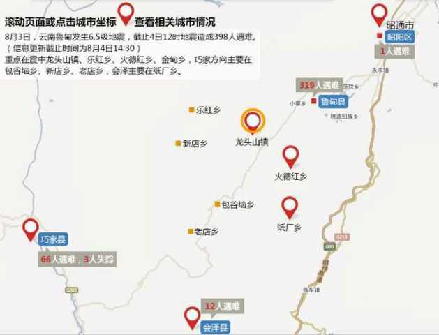
Update 14:45 UTC : Kraal river landslide lake creates a dangerous situation
The water is rising 1.1 meter per hour. 56 houses have been flooded by the water. 11 houses did already collapsed. The population of the villages immediately downstream has been evacuated. But unnecessary to tell that the situation gets more dangerous by the hour. The Chinese engineers are doing whatever they can to reinforce the possible weak points. The location of the landslide is Huize, the orange circle on the map. The red numbers on the map are the number of deaths in that area :(.
 .
.
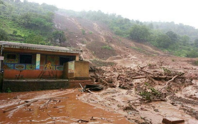
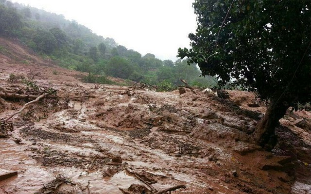
Malin landslide in Pune, India
Recovery operations continue at the site of the Malin landslide in India. Latest reports suggest that the death toll has reached 134, comprising 64 women, 50 men and 20 children. It is expected that the final toll will be about 176 people. A decision has been taken to relocate the remainder of the village.
4 August 2014
Sunkoshi landslide crisis: latest news and images
Sunkoshi landslide
Over the last few days there have been several developments in the Sunkoshi landslide crisis, some positive and some less so. The very high direct cost of the landslide is now becoming clear. Whilst only 18 bodies have been recovered to date, the number missing is thought to be about 155, making this the most costly landslide in Nepal for many years. The magnitude of the losses reflect the scale of the landslide – Kunda Dixit very kindly sent a set of images of the Sunkoshi landslide collected by the Nepal Army to me, including this overview of the site:
.
Courtesy of the Nepal Army and Kunda Dixit
The landslide is reported to be about 45m high at the highest point and 25 m at the lowest. It overtopped late on Saturday, fortunately without a breach to date, and reports suggest that the level of the lake is falling slowly. This is of course the ideal outcome, but great care is needed. If the lake level is falling then water must either be seeping through the dam or the spillway is eroding, either of which can accelerate to generate a rapid release event. Thus, there continues to be a need to manage the hazard very carefully and the ensure that areas downstream are not reoccupied.
The response of the Nepali authorities does appear to have been admirably quick and decisive, from the early action to open drainage to the large-scale evacuations downstream. It is notable that according to reports they have made use of the very high level of technical skill on landslides within in the country, which has not always been the case elsewhere.
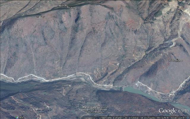
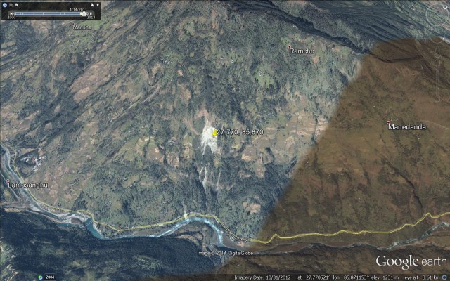
There has been some discussion in the media of the causes of the landslide. In an article today, Narendra Raj Khanal from Tribhuvan University suggested that this slope developed some instability last year. This would be consistent with the progressive development of the landslide, which is clear from the very good Google Earth imagery of the site. This is an image from 2009, as a perspective view:
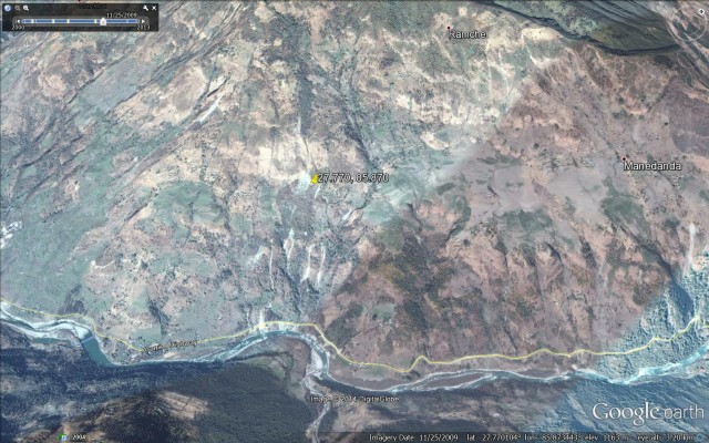
From Google Earth
.
And this is an image from 2012:
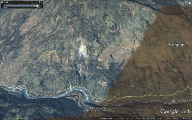
From Google Earth
.
The deterioration in the state of the middle part of the hill (around the area with the location marker) is very clearly visible between the two images. Presumably this became much worse last year.
Finally, it is important to remember that this landslide will be having devastating impacts upstream as well. Clearly the Arniko Highway is closed, and will remain so for some days to come. This is the only road to Tibet from Nepal, and of course the time period each year in which it can be used is comparatively short anyway. Those living upstream will now be isolated from the rest of the country, and of course the lake has inundated a large area of road. Kapil Dhital is a civil engineer who was at Bharabise at the time of the landslide. He has tweeted a series of photographs of the landslide and lake, including this one showing a now submerged dwelling:
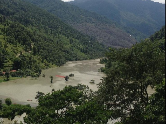
Kapil Dhital via Twitter
2 August 2014
Sunkoshi in Nepal: a valley blocking landslide crisis
Sunkoshi landslide crisis
Now updated – see additional text at the end of this post
Overnight a very large landslide occurred on the banks of the Sunkoshi River in northern Nepal. This landslide has created an instant, large-scale crisis as it has blocked the river. In Nepal the English language news media is excellent, so there is very good coverage of the event, helped also by the location of the landslide on the main road to Tibet, which facilitates access. The best gallery of images that I have seen is on the Nep Hub website. This is the landslide from the slope above:
http://www.nephub.com/latest-picture-of-sunkoshi-landslide/
.
This is the lake that is building behind it:
http://www.nephub.com/latest-picture-of-sunkoshi-landslide/
.
And, from the Only Nepal website, this is a view of the landslide from downstream:
http://www.onlynepali.net/massive-landslide-blocks-sunkoshi-river-killing-6/
.
The location of the landslide is 27.770 N, 85.870 E. The Google Earth imagery of the site is excellent:
.
My colleagues and I have been working in this valley on landslides for decade or so, and Katie Oven completed her PhD on landslides in this area. On field trips up the valley we would often stop at Lamusangu to look at the debris flow deposits at this location, so a major landslide in this area is not a surprise. However, it is now a crisis. In the peak of monsoon season the river flow is high, and the images show that the lake is filling quickly. The images suggest that there is no reason to be confident that the dam will not breach rapidly when overtopped – indeed, quite the opposite I think as the length of the dam is not large and the materials appear to be fine grained. A breach now could generate a very large flood; when full the effects could be very serious.
Mitigation is of course to try to drain the lake whist evacuating everyone downstream. The valley is quite densely inhabited because of the road. A secondary hazard is that a major flood might destabilise the walls of the valley triggering further landslides downstream. Whilst the population can be protected with appropriate measures, which need to be implemented very fast, a dam breach flood has the potential to cause major damage. Given that this is the only road north out of Nepal, and the major strategic link to Tibet and China, the impacts on Nepal could be serious in the medium term.
So what to do? Well of course the first measure is to evacuate people downstream, and this has started. The second is to put a warning system in place, probably at this stage consisting of an observation team with appropriate communications. The third will be to start to excavate a channel, which will require heavy machinery.
This is a very difficult problem to manage, so Nepal should seek international help. The best qualified people are the teams that dealt with the valley blocking landslide crisis after the Wenchuan earthquake in China. Given the strategic importance of this road, the Chinese may want to help. However, time is very limited.
Update
Ekantipur has tweeted the follow image of the landslide:
https://twitter.com/kathmandupost/status/495484816041574400/photo/1
.
This suggests that an overtopping event is probably very close, and may even have started (see comment below). The priority must be to relocate people away from the valley floor.
1 August 2014
Malin landslide in Pune: assorted news stories
Malin landslide in Pune
The Indian media has a large number of interesting stories about the Malin landslide in Pune two days ago. The rescue operations continue, in a much more organised way now. IBN reports that the death toll has reached 56 people, with nine people injured. The estimated number of people missing is in the order of 120, although hopefully this will reduce with time as the whereabouts of people not affected by the landslide becomes clear. The challenges posed by the rescue operation are clear from this image from the site:

http://ibnlive.in.com/news/pune-landslide-three-days-on-death-toll-rises-to-56-over-120-still-feared-trapped/489568-3-237.html
.
There is not inconsiderable risks to the rescue teams working in such conditions. There are however some pleasing stories about rescues, not least the recovery of a family of four from beneath the debris after a crying baby attracted the attention of rescue teams. The family survived in a house that was buried by the landslide. To survive such an event is very fortunate and generally requires a structure to provide protection.
However, inevitably the main thrust of the news reporting is less positive. The Times of India has a terrible story about the level of loss suffered by some residents of the village. 40-year-old Hirabai Chandrakant Kengale lost all 25 members of her family, consisting of her three brothers and their families. Hirabai lives in an adjacent village but had returned to help with rice planting. She was staying in a house that was not destroyed by the landslide. The same report also notes that between 25 and 30 students of various ages were sheltering in the temple at the time of the landslide. Unfortunately the likelihood of further survivors being recovered from the debris is now very low.
Interestingly the same report considers the causes of death of the victims, noting that the autopsies indicate that asphyxia was the main cause of death, with head injuries and blunt trauma being other factors.
Inevitably there is a great deal of soul searching and speculation about the causes of the landslide. In particular there is a strong emphasis on the role of deforestation, hill-cutting and other human activities. The Business Standard quotes a Communist Party of India statement that:
“The government had adequate warning in the past few years when smaller landslips had occurred and the flow of the backwaters of the nearby Dimbha dam was one of the causes. But the government did not take any preventive measures…JCB machines (excavators) were being used on the hillside in the name of developing adivasi land but (they were being used) in fact to serve the interests of a network of JCP machine owners, corrupt officers and leaders…The use of these heavy machines caused damage to the hillside. In spite of the strong opposition of adivasis to the use of machines, the government did not prohibit their use”
Pune Mirror reports that the landslide will be investigated by a team from the Geology Department at the University of Pune. Hopefully this will provide clarity about the causes of the Marin landslide.
31 July 2014
Malin landslide in Pune, India: a mass fatality mudslide yesterday
Malin landslide
Early yesterday morning a very large landslide occurred in the village of Malin in Pune, western India. The landslide struck and effectively wiped out the village of Malin, located close to Bhimashankar in the western Ghats. It is thought that about 40 houses were buried – sadly the timing of the landslide meant that most would have been fully occupied and of course the darkness would have impeded any escape. Latest reports suggest that 28 bodies have been recovered to date, together with eight survivors, but a further 150 people may still be buried. As such this is the second worst landslide of the year to date, after the Afghanistan landslide of a couple of months ago.
There is only a limited number of images of the landslide on the web, most looking like this (source):
http://www.swadeshnews.com/national/pune-village-devastated-by-massive-landslide-at-least-10-dead-150-feared-trapped-see-pics
..
The debris pile at the foot of the slope appears to be exceptionally wet:
http://www.swadeshnews.com/national/pune-village-devastated-by-massive-landslide-at-least-10-dead-150-feared-trapped-see-pics
.
The site of the landslide is quite well covered on Google Earth – the location is (19.161, 73.688) if you wish to take a look. This is a perspective view of the village and slope:
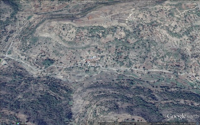 .
.
Causes of the Malin landslide
Inevitably there is huge speculation in the Indian media about the causes and triggers of the Malin landslide. The trigger is clear – this area was affected by very strong monsoon rainfall in the two days prior to the landslide. The NASA TRMM landslide warning tool highlighted this as a zone that was very susceptible to landslides in light of this rainfall:
TRMM data for the Malin landslide, sourced 30th July. Left image is the landslide warning area, right is the measured precipitation
.
The TRMM data can also be used to generate a time series graph for rainfall in the area of the landslide:
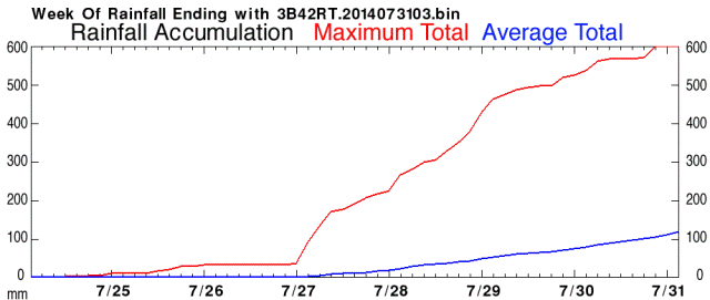
TRMM time series precipitation graph for the Malin landslide
.
The data suggests that as much as 600 mm of precipitation may have affected this area prior to the landslide occurring. In the media there is a great deal of speculation that the dam at Dimbhe, a few kilometres downstream may have been a factor. But given the distance to the reservoir, the fact that the dam was completed in 2000 and the type of landslide this is not immediately obvious to me. There is also discussion about the role of development and deforestation, which may be far more important. The landslide appears to be a mudslide in deeply weathered soils (there is no evidence of involvement of large amounts of bedrock), so this slope would be highly susceptible to disturbance. The investigation will need to look at this in detail.
The Google Earth images are hard to interpret well because of the low resolution of the digital elevation model, but I have been looking at them to see if this slope could have been identified as being potentially dangerous. This is a more detailed Google Earth perspective view of the site:
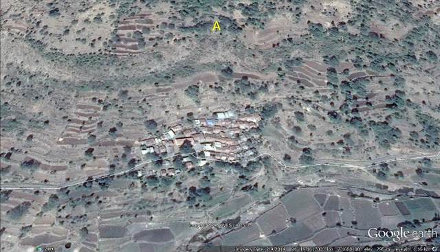 .
.
The image appears to be dated from February this year. There is no obvious signs of cracking or suchlike that I can see, which is not unexpected for a soil slide. However, the feature that I have marked A above is interesting – this appears to be a large topographic hollow. Such features can have the effect of concentrating intense rainfall during overland and soil flow. If this occurs, then pore water pressures in the soil in the hollow can become very high, initiating failure. If I was investigating this landslide I would be very interested in this hollow. The location directly above the village is deeply unfortunate if this feature was a factor.
29 July 2014
Oso landslide: differences of opinion about the landslide mechanisms
Oso landslide analyses
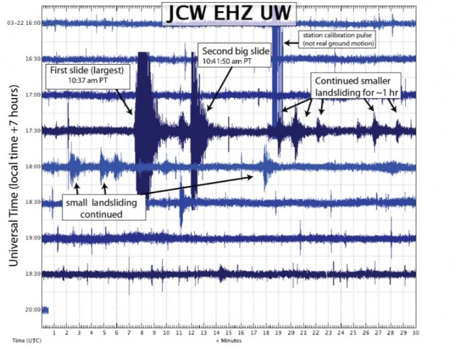
The journal Science is reporting an interesting public argument about the mechanisms of the Oso landslide in Washington State, USA. This is between the authors of the GEER report (NB pdf), which was released last week, and Dr Richard Iverson of the USGS, and is in essence about the chronology of events that generated the very rapid debris flow event that was so costly. I wrote about the GEER report last week, and noted that they interpret the sequence as being a two-fold failure event, as indicated by the seismic data. The latter is not controversial – there is a nice (pdf) report from the Pacific Northwest Seismic Network that shows this double event very clearly:
http://wa.water.usgs.gov/data/SeismicReport-OsoLandslide.pdf
.
In the GEER interpretation of the Oso landslide the lower slope failed first to generate the rapid flow event, followed by the second failure, which was in effect a retrogression of the landslide as a new block slid onto the main mass, and then stalled. This is consistent with the fact that the first event generated a much larger seismic signal; and the fact that the, second seismic signal appears to terminate quickly.
However, in the Science report, Dr Iverson disagrees with this interpretation of the Oso landslide, based on a more detailed analysis of the seismic signals The report notes that:
“But Richard Iverson, a landslide expert at USGS’s Cascades Volcano Observatory in Vancouver, Washington, says that a closer look at the seismic data tells a different story. “The USGS disagree[s] significantly with several aspects of the GEER report,” Iverson says. According to the unpublished analysis by scientists with the USGS and the University of Washington, all the important action appears to have been compressed into a rapid chain reaction in the first few minutes. The lower slope began to slide slowly, but just 50 seconds after that began, an upper part of the mountain broke loose and collapsed onto it. The violence of that impact could cause the soil to rapidly liquefy and shoot across the valley, much like a foot slamming down into a mud puddle, he said. Iverson and scientists working with him concluded the second incident recorded in the seismic data was an ‘extremely small event.'”
I have no experience of interpreting seismic signals from landslides, so struggle to comment either way on this interpretation. I think I can see the essence of this interpretation in the data from the more distant seismic stations:
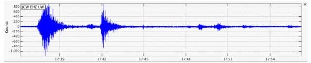
http://wa.water.usgs.gov/data/SeismicReport-OsoLandslide.pdf
.
To my untrained eye the initial seismic event shows a slow increase in energy release rather than an abrupt peak. Note also that the second event appears to be much smaller than the first. Thus, in this interpretation, the initial failure was, I think, a small, slow failure in the lower slope that destabilised the upper block of the Oso landslide, which slid onto the mass below. This then generated massive undrained loading, allowing the generation of very high pore water pressures, and hence the high mobility flow. The second seismic event is interpreted as being “extremely small”.
I think one can take issue with the latter statement – if it was extremely small it would not have generated a seismic signal, surely – but the point is that it is relatively small when compared with the first failure. The Science have clearly put this alternative interpretation to the GEER team, and report as follows:
Responding to Iverson’s critique, GEER co-leader Jeffrey Keaton, an engineer at AMEC Americas, a private engineering firm, says that observations in Oso helped convince them that much of the mountain collapsed a few minutes after the initial slide. Large chunks of relatively intact earth still covered with trees would probably have broken up if they had been part of the first slide, he said. And swaths of sand had flowed up onto the back end of the first slide, suggesting it happened after the first slide slowed to a halt.
The data that is available is insufficient to be able to make a definitive argument either way on this – the next key step will be publication of the UGSG analysis that supports their line of argument. In essence the issue is the chronology of events shown in this Seattle Time image of the landslide:
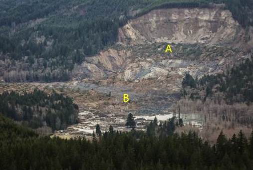
Image: Seattle Times
.
At the end of the day, this comes down to whether the most likely scenario is that the block that was formed from material marked B above failed (event 1), allowing block A to slide in (event 2); or whether block A failed, causing massive collapse of block B (event 1) followed by a small but at present unknown slide that generated event 2. I would guess that a very detailed analysis of the deformation at the front end of block A might help – if this block moved after Block B had failed then there should be some impressive compressional deformation features preserved in this area. Maybe the very high quality Google Earth imagery collected on 1st April would allow someone with the right skills to make an interpretation?
Personally I can see merits in both interpretations, so will watch with great interest as this is resolved.
 Dave Petley is the Vice-Chancellor of the University of Hull in the United Kingdom. His blog provides commentary and analysis of landslide events occurring worldwide, including the landslides themselves, latest research, and conferences and meetings.
Recent Comments