

4 March 2016
Kalimpong Day 2: landslides on the eastern face
Kalimpong Day 2: landslides on the eastern face
Day 2 of the SHAMROCC field visit (day 1 is here) involved a tour, ably guided by Wing Commander Praful Rao, of landslides on the eastern face of Kalimpong. It soon became apparent that this is a very landslide-prone area, and that many of the slides are large and active. For example, this road crosses a big creeping landslide complex, as the image below shows:
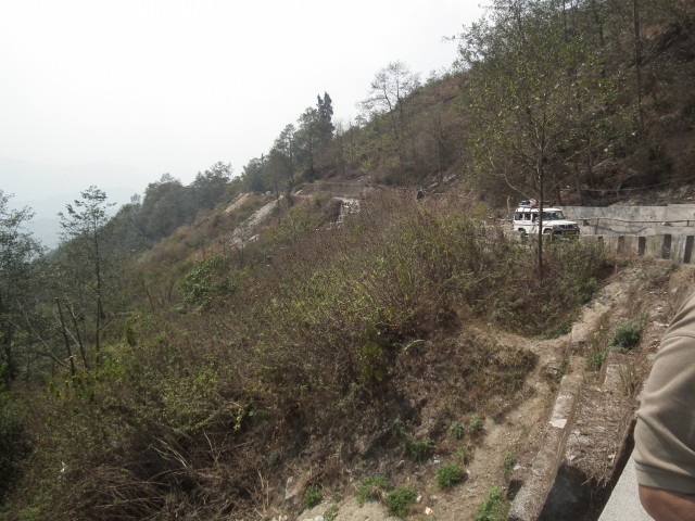
Kalimpong Day 2: An example of a landslide on the eastern face
.
I took the image above from a bridge over a culvert that marks the lateral slip plane of the landslide, which extends right across the image above. This culvert showed some interesting signs of mass movement problems, with evidence of both movement across the structure and the impact of debris flows that have come down the channel. For example, one of the steel joists supporting the bridge deck has been broken and displaced by an impact event. Note also the large cracks in the abutment – this is the landslide side of the culvert. Finally, note the pile of construction waste dumped under the bridge. This is simply bad practice that can only lead to further issues downstream:
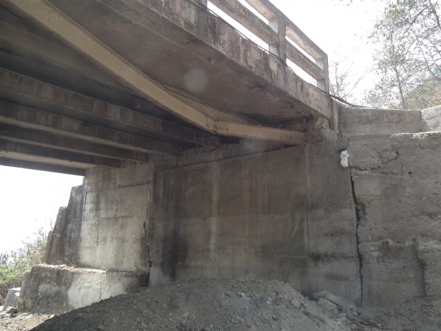
Kalimpong Day 2: damage to a culvert by mass movement events
.
Parts of this landslide are moving quite rapidly. This section of road has both dropped and displaced as a result of movement of the landslide. The deformation in the retaining wall, which has dropped and bulged, is stark:-
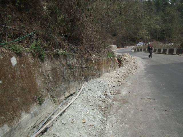
Kalimpong Day 2: deformation in a retaining wall caused by movement of a landslide
.
Further along the road, and down the hill, we came across another large, very active landslide complex. On the face of it this is an idyllic location for a small community:
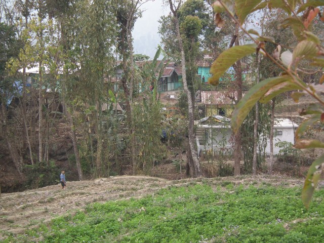
Kalimpong Day 2: An idyllic rural community?
.
However, immediately down slope from the hamlet is the back scarp of a large, expending and dramatic landslide complex. This is a retrogressive block slide – the current block at the crown has displaced about three metres. It cannot be long before the next block slips, at which point parts of the village will be lost. The displaced block is on the right, note how close the house is to the current crown of the landslide:
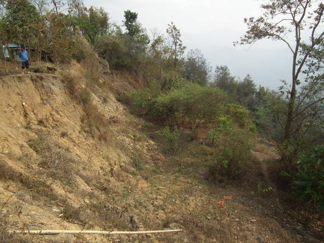
Kalimpong Day 2: a large displaced block and a threatened house on the eastern face
.
The material that is forming this landslide is interesting – it is clearly not bedrock, but is instead a thick layer of bouldery material that I would probably class as colluvium. My suspicion is that these middle slopes in the Kalimpong area are frequently formed of ancient, dormant landslides. In many places these landslides have been reactivated, and these movements are now threatening the communities that live upon them. In my next post I will show some more, very dramatic, examples. In the meantime of course the situation for this community is desperate. They know that their way of life is endangered by this landslide, but they are powerless to intervene and no-one in government has provided help. Meanwhile, Save the Hills continues to campaign to raise awareness of these hazards and to try to mobilise some action.
1 March 2016
Darjeeling day 1: Landslides on National Highway 10
Darjeeling day 1: Landslides on NH10
For five days I am in Darjeeling in northern India on a visit organised under the UKIERI programme. We are staying in Kalimpong, a hill town with a serious landslide problem, working alongside Praful Rao and colleagues of the wonderful Save the Hills NGO. It has long been an ambition of mine to visit this area, and it is a great pleasure to meet Wing Commander Rao, who has long been a hero of mine. I can think of no NGO that has done more to raise awareness of landslides in their local area than Save the Hills.
Yesterday (Monday) we drove from Bagdogra Airport up to Kalimpong via National Highway 10. Along the way were met by the officers from the Border Roads Organisation (BRO), the part of the Indian Army responsible for maintaining the roads in the Himalayas, who were keen to show us a serious landslide problem on this strategically vital highway. This landslide activated in heavy rainfall in the early part of the 2015 monsoon, and during the major movement period it blocked the highway for five days. The BRO had a backhoe buried in the landslide, although fortunately the operator escaped uninjured.
This is the landslide as it is now. As you can see, our visit was in rapidly failing light, sadly.
.
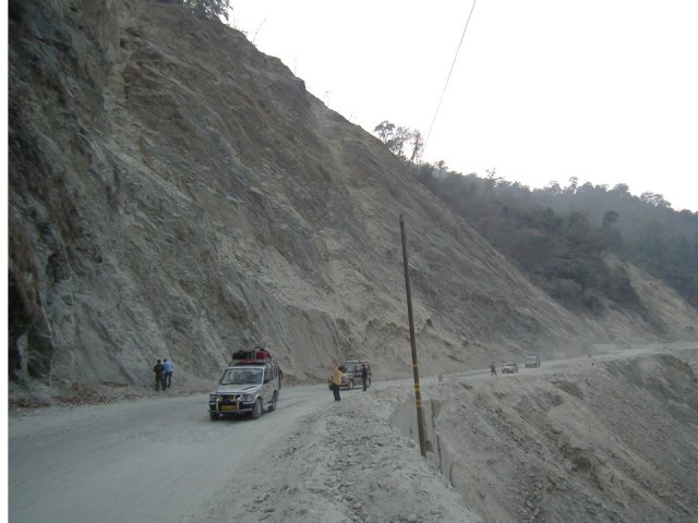
The major landslide on NH10 in Darjeeling, India
.
There is clearly a great deal of loose material on the surface of this slide, and the threat that this will pose in the 2016 monsoon in three months is clear. I wonder though if the major issue here may be a deeper seated movement in the block that is directly above the silver car in the image above. That is the section of the slope shown below. My view would be that this section of the landslide needs to be monitored to understand what is happening here.
.
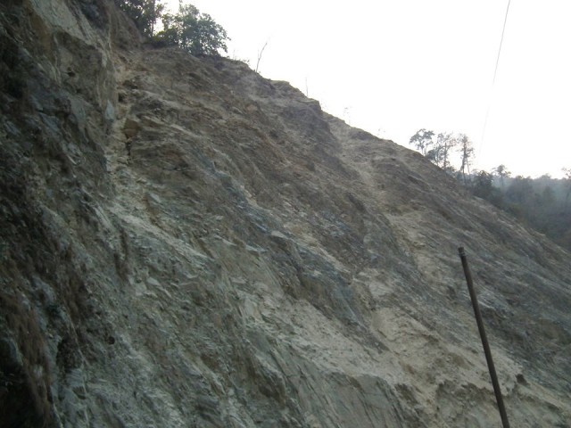
Detail of the major landslide on NH10 in Darjeeling, India
.
Viewed from the other side, it is also clear that there is another major block on the margin of the existing landslide that is potentially unstable. It appears that a tension crack has opened at the back of the block (note the fresh rock that has been exposed in the upper right portion of the image). Again, it is hard not to believe that this will cause problems in the future:
.
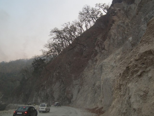
Potential new areas of instability on the flank of the major landslide on NH10 in Darjeeling, India
.
29 February 2016
Elk City landslide: a very interesting video
Elk City landslide video
The Elk City landslide happened on 18th February on State Highway 14 on the South Fork of the Clearwater River near Elk City in Idaho, USA. The landslide was captured in a remarkable video by a member of a road clearance crew who were at the scene at the time. The Idaho Statesman describes it as follows:
“We were just up there doing some routine road maintenance,” said ITD transportation technician Bret Edwards. The video initially just shows rocks tumbling down the hillside onto the highway. Then a larger piece of the hill begins to move, and you can hear Edwards shouting as he runs away from the massive landslide. The entire hillside sloughs off and the camera spins around. When all was done, dirt, rocks and trees covered a 500-foot stretch of the road about 40 feet deep.
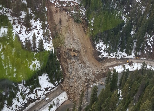
Aerial view of the Elk City landslide as captured by the Idaho Transportation Department
.
This a shallow rockslide, probably in deeply weathered rock. The really interesting aspect of the video is the way that the final movement event developed, yet again showing an increasing event rate of smaller falls and slides as the underlying landslide mass accelerated. Even then it was not obvious to the road crew that a major collapse was imminent. As the image above shows, removing the debris will be a large and expensive task. It will be interesting to see if the adjacent slopes are suffering from stability issues as well. And note that the the crown (top) of the landslide there is unstable and displaced material that has yet to fail. This material will need to be managed as failure would lead to it being deposited on the road once again, and as such it is a significant hazard.
27 February 2016
Vajont – La diga del disonore: the landslide scene
Vajont – La diga del disonore
Vajont – La diga del disonore is a 2001 movie by the Italian director Renzo Martinelli that dramatises the events of the 1963 Vajont disaster. It has not been widely shown outside of Italy. There is a good Wikipedia page in Italian about this movie. The film tells the story of the tragedy, which killed over 2000 people, from both the perspective of the people of the towns that were swept away by the flood generated by the landslide, and those who were responsible for building and commissioning the dam that triggered the landslide.
In the last week someone has posted to Youtube the 5 minute section of the film in which the landslide occurs. It is both dramatic and terrifying, capturing not only the failure of the landslide but also the impact on the people who were killed. It is not easy view, but it is deeply moving. You should be able to view it below:
.
There are many videos of landslides occurring in real time now, but few that capture the ways in which they affect people. The power of this movie lies in the way that it covers this issue, without being gruesome or gratuitous.

Still from Vajont – La diga del disonore
25 February 2016
The Vajont Slide: A new event chronology and the importance of geomorphology
The Vajont Slide: A new event chronology and the importance of geomorphology
The Vajont Slide has been studied for over 60 years, yet many open questions on the initiation, mechanics, and kinematics of the landslide remain. In our new new paper (Wolter et al. 2015) we have attempted to answer some of these questions using a multi-faceted approach focused on the geological and geomorphological context of this infamous event. This is an aerial image of the landslide, taken in 1964. Note the dam in the upper left of the image. The huge landslide is on the southern side of the valley. The stripping of vegetation on the northern side gives an impression of the size of the displacement wave generated by the Vajont slide. It is this displacement wave that caused over 2000 fatalities in the valley below the dam.
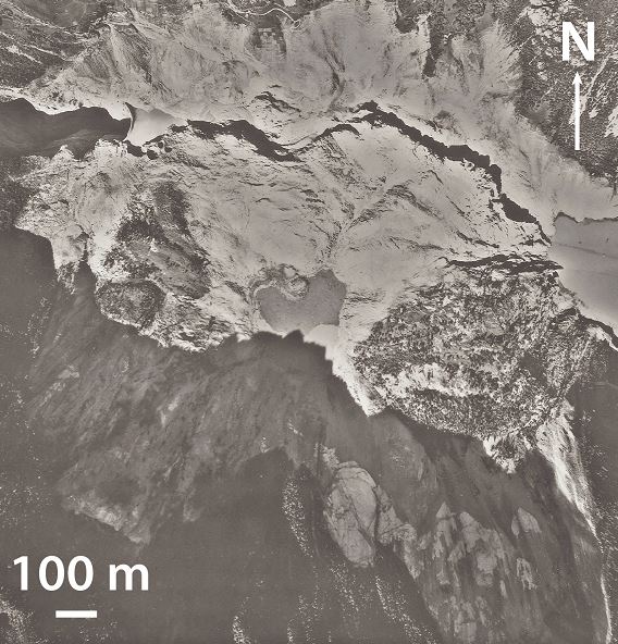
Aerial photograph of the Vajont slide in 1964 (headscarp in South), courtesy of the Friuli-Venezia-Giulia region.
.
Highlights of our paper includes the first detailed engineering geomorphology maps, pre- and post-event, of the Vajont Slide, allowing:
- the morphometric characterisation of surface features such as benches, tension cracks, ridges, and depressions;
- the identification of active processes over time, including gully incision, fluvial erosion, and shallow slope failures;
- the interaction between structural and geomorphic features; and
- the delineation of landslide blocks or compartments within the landslide deposits.
The discussion of the origin of the Vajont Gorge just downstream of the landslide, in which we show that there is evidence that suggests this important knickpoint originated due to slope deformation. In the paper we emphasise the importance of spatial and temporal damage within the prefailure rockmass, and in particular we show that:
- zones of the rock mass have different mechanical properties, the eastern zone being more damaged than the western zone;
- damage related to pre-existing faults as well as progressive weakening through geomorphic and internal deformation processes; and
- the Vajont Slide is structurally controlled, occurring at the intersection of two synclines and bounded by two faults.
All of this allows us to draw together a chronology of events for the Vajont Slide, which is summarised in the figure below:
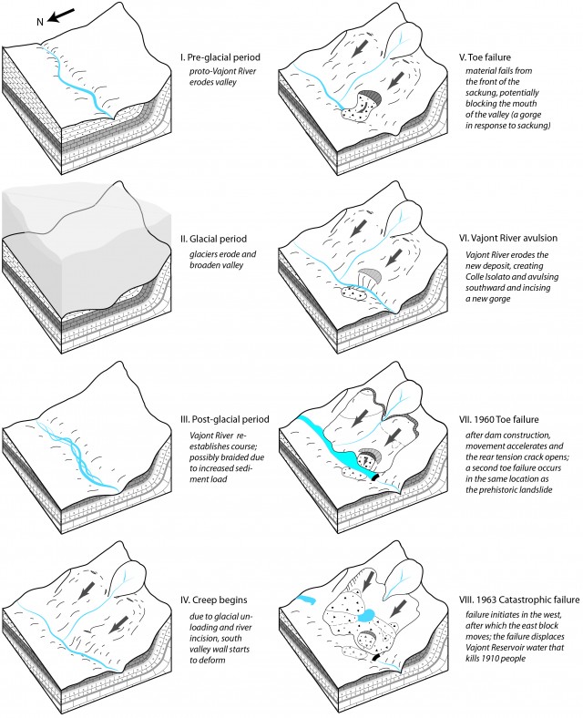
Hypothesised schematic chronology of events leading up to the catastrophic Vajont Slide.
Thus, we suggest that he catastrophic event, likely triggered by repeated and rapid reservoir drawdown, was the culmination of slow gravitational slope deformation.
In the paper we also think through the key question of why the landslide occurred at this location. We propose that there was a unique combination of factors, including structural predisposition (folding and faulting), lithological units (weak clays vs. rock mass), glacial erosion and possible debuttressing, fluvial undercutting, weathering, and reservoir levels.
The broader implications of our paper are:
- geomorphic and tectonic processes often act in concert to damage rock slopes and bring them to failure;
- engineering geomorphology, combined with other techniques such as rock mass characterisation, remote sensing, and numerical modelling, is a useful tool to analyse processes influencing rock slope stability and the evolution of slope instabilities; and
- the geological and geomorphological context of a landslide is a critical consideration in forensic and predictive investigations, allowing the examination of conditioning processes and location.
Reference
Wolter, A., Stead, D., Ward, B.C., Clague, J.J., Ghirotti, M. (2015) Engineering geomorphological characterisation of the Vajont Slide, Italy, and a new interpretation of the chronology and evolution of the landslide. Landslides. DOI: 10.1007/s10346-015-0668-0.
24 February 2016
Annapurna: a large rock avalanche on 23rd Feb?
Annapurna rock avalanche
Various news agencies in Nepal are reporting that there was a large dry landslide, which will mean a rockslide, in the Annapurna area of Nepal yesterday. For example, Republica reports the event as follows:
The massive landslide that hit Narchyang area near the Annapurna South Peak in Myagdi district at around 3 am on Tuesday caused a magnitude 3.8 tremor, according to the National Seismological Center (NSC). “The dry landslide produced a magnitude 3.8 tremor. Small landslides do not create tremors of this magnitude,” said Lok Bijaya Adhikari, chief of the center…Thick clouds of dusts produced by the continuous landslides have affected normal life in Narchyang, Dana, Bhurung, Tatopani, Shikha, Ghar and Dowa VDCs. DSP Bishwa Raj Khadka, chief of District Police Office (DPO), Myagdi, informed that Nepal Army and Police personnel are having difficulties reaching the uplands due to the thick dust and haze.
All the indications are that this was a very large landslide – the dust plume, reports that it has blocked the valley and of course the detection of a seismic signal. As yet there are no images, but reports suggest that the Ghalmedi Kola (river) has been blocked. I believe that this is the channel in the centre of this Google Earth image (NB this is a correction from earlier after further research):
.
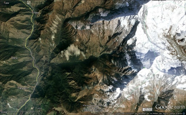
The Ghalmedi Kola in the Annapurna area of Nepal via Google Earth
.
News reports suggest that a team has been dispatched to take a look, so hopefully more information will emerge in the next few days. Sadly the seismic event associated with this landslide is too small to have appeared in the online seismic catalogues as far as I can tell. In the image above there are various locations in which a large slope failure could have occurred.
There were news reports yesterday that five people were missing in this landslide, but these individuals have now reappeared.
23 February 2016
Ropoto: a town in Greece lost to a landslide
Ropoto in Greece
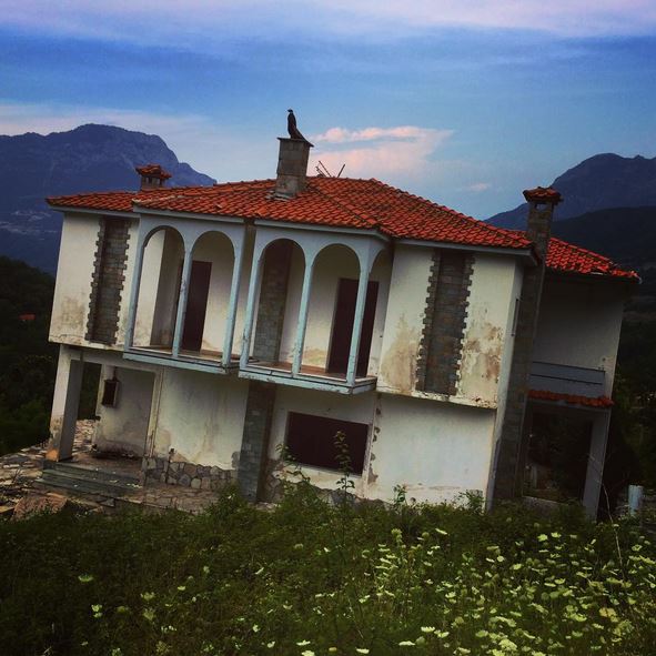
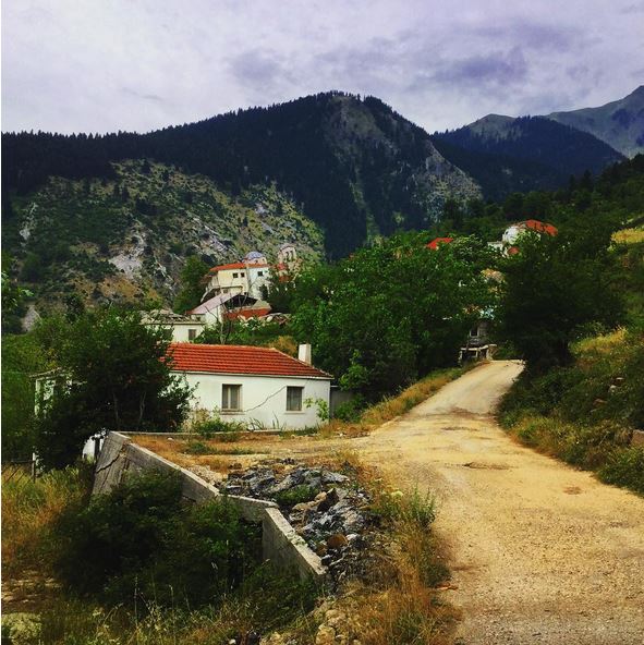
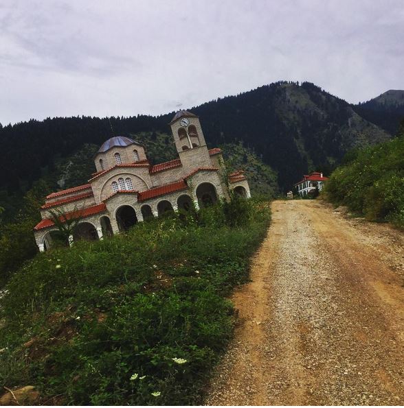
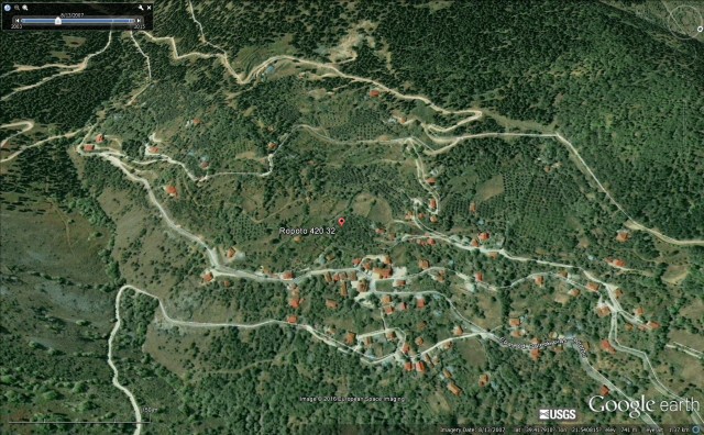
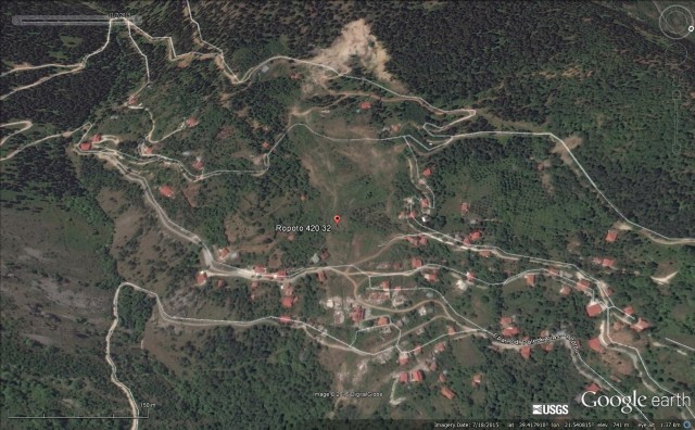
In the last week a few media outlets (such as Atlas Obscura) have carried reports about the town of Ropoto in Greece, which in 2010 was abandoned due to a landslide, inspired by an article on the Greek Explorer website. The latter has made a short documentary about the town, and its landslide. The short description that goes with the film is as follows:
Ropoto was once a thriving village and home to 300 families, but a landslide in 2012 turned the village into a ghost town. Today, forgotten by people and authorities, Ropoto’s terrain is still sinking, slowly moving the half-standing structures.
Ropoto landslide via Instagram and Aris Skoulis
Ropoto landslide via Instagram and Aris Skoulis
Ropoto landslide via Instagram and Aris Skoulis
Ropoto landslide via Google Earth
Ropoto landslide via Google Earth
22 February 2016
How do geomorphic and seismic processes cause large catastrophic landslides? A case study in Montana, USA
How do geomorphic and seismic processes cause large catastrophic landslides? A case study in Montana, USA
By Andrea Wolter, ETH Zurich
Although much research has been conducted on seismically triggered landslides, the long-term effects of seismicity on rock slopes and their interaction with other actors such as geomorphic processes remain poorly understood. In a recently published paper (Wolter et al. 2015) we investigate the 1959 Madison Canyon Slide in Montana, USA, the most devastating secondary hazard of the M 7.5 Hebgen Lake earthquake. We combined geotechnical surveys, long-range terrestrial digital photogrammetry, engineering geomorphology mapping, and 2D numerical simulations in an integrated approach to understand the conditioning factors, mechanics, kinematics, and evolution of this catastrophic event and metastable rock slopes in general.
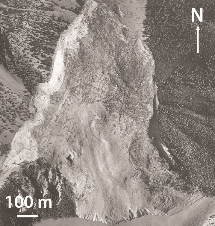
Aerial photograph of the Madison Canyon Slide (headscarp in the South), courtesy of the U.S. Geological Survey.
.
In our study we used field and photogrammetric geotechnical surveys, as well as laboratory tests, first to determine of rock mass and discontinuity properties at the site. Several discontinuity sets, including foliation, were identified. Interestingly, though, the landslide was not controlled by these discontinuity sets. Rather, composite surfaces incorporating multiple discontinuity sets appear to have acted as the main rear and lateral release surfaces.
Engineering geomorphology mapping aided in the delineation of ten landslide compartments or blocks within the deposit, as well as compressional and extensional zones, indicating how the rock mass failed. Post-event debris slides and rockfalls, as well as anthropic modification of the landslide deposits, were included in the evolution of the event, based on multi-temporal aerial images. Geomorphic processes such as undercutting of the marble unit at the base of the slope, gully incision, and weathering are thought to be relevant to slope failure.
Our preliminary seismic modelling highlighted the role of pre-existing compliant fractures in amplifying seismic waves, particularly at the crest of the slope (see figure). Topographic amplification was shown to be less critical. Simulation of multiple earthquakes in the models indicate the significance of seismic fatigue in slopes, leading to failure.
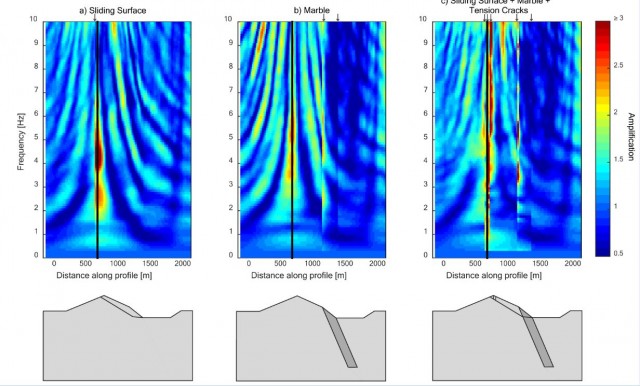
Amplification field plots for three discontinuity geometries at Madison Canyon. Warm colours represent areas of high amplification. These maximum amplification zones correspond to locations where compliant fractures intersect the model surface, indicating their importance. See paper for further explanation.
.
By combining the field, laboratory, and simulation results we were able to reconstruct a chronology of events at the Madison Canyon site, from the development of initial tension cracks at the crest of the slope and the cumulative damage of the rock mass to the triggering of the catastrophic failure and subsequent evolution of the deposits.
The broader implications of our paper are:
- the case study demonstrates that long-term seismic (earthquake) and geomorphic damage are important, yet often neglected, mechanisms in bringing a slope to failure; the seismic “past” of the slope (i.e., past earthquakes damaging the slope) may have had an important impact on stability.
- topographic amplification of seismic waves is less critical than damage amplification related to pre-existing and seismically induced discontinuities.
- the ability to determine reasons for the exact location of this landslide (topographic, geomorphic, mechanical, and seismic effects) contributes to the understanding of slope behaviour.
Reference: Wolter, A., Gischig, V., Stead, D., Clague, J.J. (2015) Investigation of geomorphic and seismic effects on the 1959 Madison Canyon, Montana, landslide using an integrated field, engineering geomorphology mapping, and numerical modelling approach. Rock Mechanics and Rock Engineering. DOI: 10.1007/s00603-015-0889-5.
18 February 2016
An update on the Yaglidere Landslide, including another video
An update on the Yaglidere Landslide
Yesterday I blogged about the Yaglidere landslide. I have tracked down a second video on Youtube, in some ways even more dramatic than the original:
The video of the Yaglidere landslide was posted on the website of the Yaglidere Gazette (I’m sure you are all avid readers already), who also has a news report (in Turkish) about the landslide, which includes this image of the aftermath:
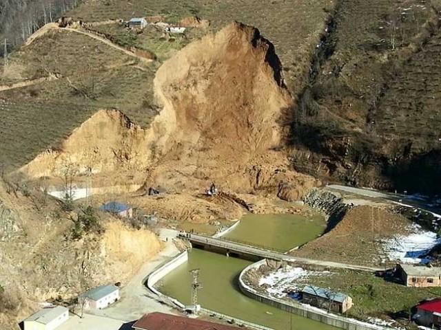
Yaglidere landslide via the Yaglidere Gazette
.
This image shows that the landslide was on the outside of a river bend. It appears that there might have been some works going on at this site prior to the failure, but this may have been clearance of the debris from earlier landslides.
Caner Zanbak via a comment on my original post has very kindly provided this information:
The landslide referred in the video at Yaglıdere, Giresun, Turkey (37T467890E, 4503640N at 650 m MSL [I am not sure how to interpret this location – D]) occured on 4 February, 2016 following quick melt of accumulated snow by heavy rainfall events. Based on the information provided by engineering geologist Assoc. Prof. Hakan Ersoy ([email protected]) of Karadeniz Technical University in Trabzon, Turkey, surface morphology at the landslide area reveals likely presence of large-scale paleo-landslide mass overlying the highly weathered (exfoliated, arenaceous, argillaceous) intrusions of the upper Cretaceous Kaçkar Granitoids. The recent landslide has taken place in the paleo-landslide mass.
As seen in the related video showing the ultimate failure, the landslide was triggered by the earlier erosion of the natural slope toe by the river and progressed upwards under a combination of inclined base and pseudo-circular failure mode. The height of the near vertical exposed slide surface is approximately 20 meters. Please note that another slope on the left side of the current landslide is prone to a similar failure..
———-
Regarding the Google Translation of the news article: below is a better (?) English version:
“Recently, the soils softened due to rainfalls caused a landslide in Giresun–YAĞLIDERE [Yaglidere in the English spelling]. A mountain-size mass landed almost flat in a landslide occurred along the roadside. The foothills started to break at the beginning followed by a large mass landing on the river bed. Those who were at the roadside barely saved their lives.”
This provides a much better insight into the events associated with the Yaglidere landslide, and I very much appreciate his help.
17 February 2016
Yaglidere – a dramatic landslide video from Turkey
Yaglidere landslide
This video was posted on Youtube on 11th February 2016. It appears to have occurred at Yaglidere in Giresun, Turkey. The comments that accompany it are in Turkish – Google Translate makes an interesting job of it (I have added some comments):
Giresun–YAĞLIDERE [Yaglidere in the English spelling] recently softened due to rains caused a landslide territory. The landslide occurred on a mountain roadside husband [I think husband is a mistranslation here – something to do with the landslide mass] landed almost flat. Mountain foothills before the break and then began her husband [mistranslation again for the landslide mass?] went down to a part of the river bed. Barely escaped with their lives on the edge of the road.
I think you need to read between the lines a little to understand this one, but if you do it seems quite clear.
.
The development of the final collapse is certainly dramatic Note how the landslide transitions from an intact sliding block:
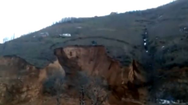
Yaglidere landslide via YouTube
.
Into a fragmented highly mobile mass in just a couple of seconds:
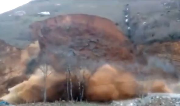
Yaglidere landslide via Youtube
.
The displacement of the water in the river is certainly impressive. The landslide appears to be in fine grained silts or sands – possibly loess? I cannot find any information about the superficial geology of Giresun.
 Dave Petley is the Vice-Chancellor of the University of Hull in the United Kingdom. His blog provides commentary and analysis of landslide events occurring worldwide, including the landslides themselves, latest research, and conferences and meetings.
Recent Comments