

27 March 2016
Remarkable new footage of the mudflow from the Samarco tailings dam failure in Brazil
Remarkable new footage of the Samarco tailings dam failure in Brazil
An amazing new video has appeared on Youtube showing the mudflow that was released by the Samarco tailings dam failure in Brazil on 15th November 2015. I covered this event at the time, and investigations continue into the cause and blame. This video is accompanied by some text in Portuguese. Google Translate, with some edits by me, renders this as follows:
In an unprecedented video posted by one of the witnesses of the tragedy on a social network can be seen the strength of brown mudflow that came down from the mountains, reaching and destroying communities and all that was ahead. The desperation is of the three people who were close to Bento Rodrigues, Mariana district of Minas Gerais Central Region, which was devastated by mud tailings from the Fundão dam, on November 5, 2015
.
.
Although quite distant, the extraordinary pace and power of the mudflow is clearly apparent:
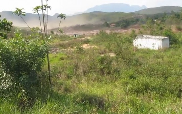
A still from the new Youtube video of the Samarco tailings dam failure
.
This is a video that all people responsible for designing and managing tailings dams should view.
Meanwhile, the enormous cost of this event is becoming more apparent. BHP Biliton, co-owner of Samarco, has produced a website that outlines the work that they are undertaking in the aftermath of the disaster. The Telegraph reports that the mine will reopen towards the end of the calendar year, with the tailings being stored in two pits whilst the dam is rebuilt. O Globo reports (in Portuguese) that the tailings are damaging the ecosystem at the mouth of the Rio Doce, down which the mudflow travelled, Meanwhile, sales of fish in Colatina are reported to have fallen as people are worried that they might have come from the polluted waters of the Rio Doce.
24 March 2016
The Yale Himalaya Initiative landslide hazard map for Nepal
The Yale Himalaya Initiative landslide hazard map for Nepal
An article by the Yale Himalaya Initiative has announced the development of a new landslide hazard map for Nepal. This map, below, was built by a team who “created a model to identify high-risk areas. Their model incorporated elevation, aspect, slope, roads, population centers, rainfall patterns, and drainage systems.” It appears that this was based upon a more local scale approach used by ICIMOD. The resultant map divides the country into four hazard classes:
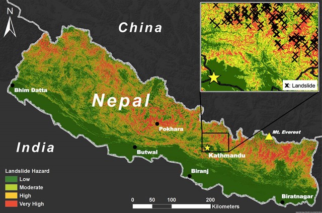
The Yale Himalaya Initiative landslide hazard map for Nepal
.
The article claims that the technique has remarkable skill in identifying areas of high hazard. One of the team, Ross Bernet, is quoted as saying:
“Our model is 84-percent accurate based on the data we had…We’ve said, ‘Here’s where we found the data, here’s what we’re working with, here’s what we did.’ The hope is that someone who might be using the map to make decisions that affect people’s lives really understands all of that.”
On the face of it this is very laudable, but I have reservations. think a few key points are pertinent here. The first is that one needs to be very careful to define terminology. In particular, the use of the terms hazard and risk have particular meanings in this context, and they should not be used interchangeably. It is far from clear to me as to whether this is a hazard map or a risk map (the inclusion of population centres may indicate the latter?), or maybe a susceptibility map. Second, it is really important to be clear about which type of landslide trigger is being discussed. Seismically-induced landslide hazard will be different from that for rainfall, so which is being accommodated here? Given that seismic hazard is not included as an input, it would seem it is just rainfall induced landslides, but the inset map suggests that the landslide inventory was for seismically-induced failures. And third, great care must be taken with statements about accuracy. I could decide that all of Nepal is high hazard, and claim to be 100% accurate because all of the landslides are in my high hazard zone. But this is meaningless of course. Defining what is meant by accuracy is really important. We must not get into a situation in which decision makers think we can assess the hazards of landslides with very high levels of accuracy. We simply cannot at present, and that is not for a lack of trying.
A second key issue for me is that this work appears to be presented in isolation. Bu this is not the first national scale landslide map for Nepal. The Nepal Hazard Risk Assessment (NB the link is to a PDF) project of a few years ago, which was led by a very credible and experienced international team who really understand both landslides and risk, undertook a detailed assessment of a range of hazards in Nepal, including landslides. They generated two maps of national landslide susceptibility (not hazard or risk). This one for rainfall-induced landslides:
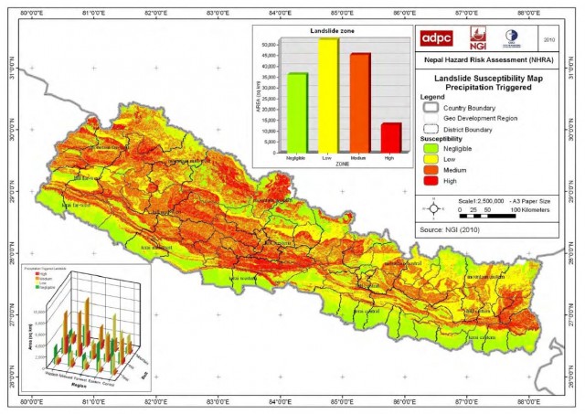
The Nepal Hazard Risk Assessment Project map of rainfall induced landslide susceptibility
.
And the other for seismically-induced landslide hazard:
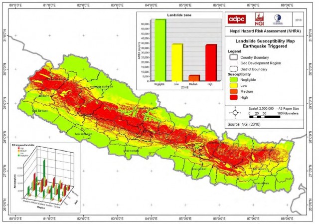
The Nepal Hazard Risk Assessment Project map of seismically-induced landslide susceptibility
.
There are huge differences between these two maps of landslide susceptibility, and between these maps and the one generated by the Yale Himalaya Initiative. There is a real danger of confusion here, which I find very worrying.
I have been collecting data on landslides that kill people in Nepal for 16 years. Technically this is of course the realisation of landslide mortality risk (and I note that the Nepal Natural Hazard Risk project maps do not show risk – I am unsure as to whether this aplies to the Yale Himalaya Initiative map as well), . Below is a map of fatal landslides across Nepal for example from my data (these are all rainfall-induced landslides):
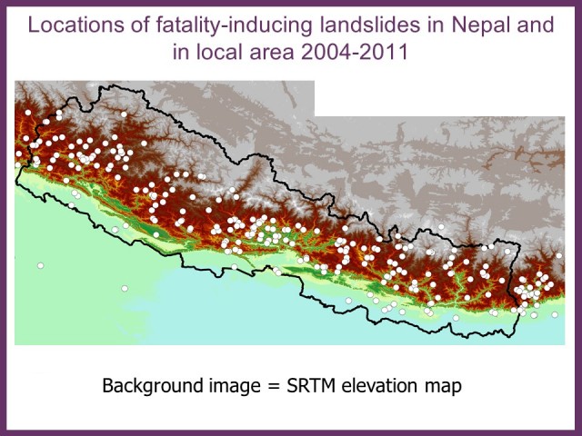
Map of fatal landslides in Nepal from my fatal landslide database
.
There is a notable difference in the location of these landslides and the landslide hazard map from the Yale Himalaya Initiative. The Nepal Hazard Risk Assessment Project appears, at least superficially, to explain the distribution much better.
I realise that I might sound overly critical in this post – that one could take the view that every initiative of this type is a good thing. And I recognise that this work is built upon the strengths of ICIMOD. But releasing a map into the wild like this without providing an explanation for what it actually shows and how it was derived feels unhelpful. This feels even less satisfactory when high levels of accuracy are claimed but are not explained or justified.
Landslide hazard mapping is deeply challenging. There are no simple fixes in my view,
22 March 2016
Multiple landslides in the last few days in northern India and Pakistan
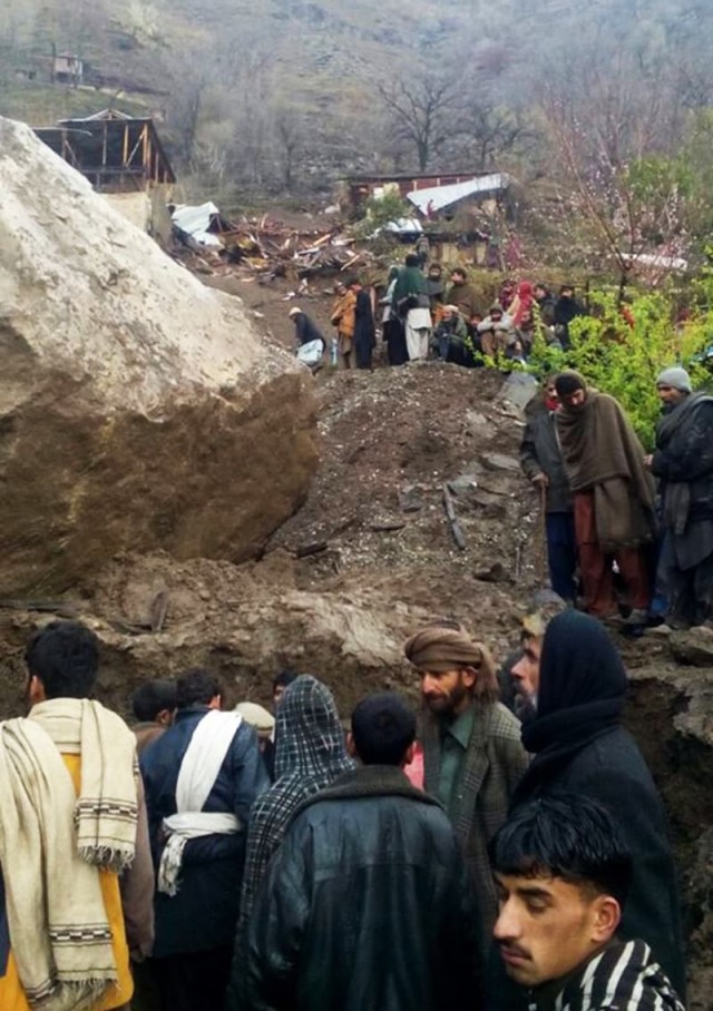
Damage to houses in Pakistan caused by one of multiple landslides in the last few days, via Dawn
.
Multiple landslides in the last few days in northern India and Pakistan
Heavy rainfall in the last few days in northern India and Pakistan has triggered extensive landsliding, resulting in surprisingly high losses. Whilst this is an area that receives Spring rains, multiple landslides to this degree are not normal, it being some months prior to the development of the southwest monsoon. Key incidents include:
1. Susam, Chitral, Pakistan
A mudslide triggered by heavy rainfall killed eight ninth grade students returning from exams. Some reports have suggested 9 or 11 fatalities, and there is some confusion over whether this might have been an avalanche.
2. Ramsu area of Ramban district, Jammu and Kashmi, India
Five people died, and three were injured, when a taxi was knocked off the road and into a river by a rockfall.
3. Multiple landslides on the Jammu-Srinigar highway
Reports indicate that the road between Jammu and Srinigar was closed by landslides at Sher Bibi, Panthyal, Battery Chashma, Marog and Anokhi Fall, trapping more than a thousand vehicles.
4. Multiple landslides on the Doda-Batote highway
A massive landslide at the Raggi Nullah blocked the sole highway linking these twin districts. Reports suggest hundreds of vehicles were trapped.
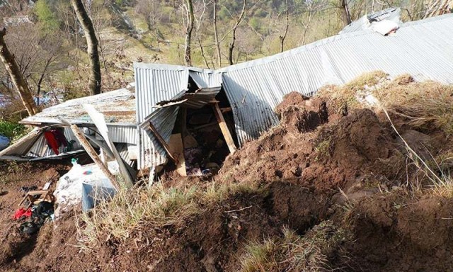
Damage to a house in Pakistan caused by one of the multiple landslides in the last few days, via Dawn
.
5. A rockfall at Sarli Sacha Sharqi village
Five people, including four children, were killed when a boulder flattened a house in Sarli Sacha Sharqi village, in Pakistan’s Azad Jammu and Kashmir, late on Friday night. One child survived.
6. A landslide at Ochar Mohalla in Bagh District
A couple were killed by a landslide at Ochar Mohalla on the outskirts of Bagh City. A child survived the landslide.
7. Multiple landslides in Murree in Pakistan
Reports suggest that the Murree area of Pakistan has also been very badly affected by landslides. Dawn reports that “Almost half the village of Graan-Ghoe was destroyed when a landslide damaged 30 homes, and the residents have no other choice but to wait out the rain under the open sky. Houses were also destroyed in Potha, Sehana, Phagwari, Aloit, Sehrbagla, Masot, Dewal and Phaphril among other villages, where roads and other infrastructure worth billions of rupees was also damaged.”
8. A fatal landslide at Jaglote in Gilgit
A woman was killed in a fatal landslide at Jaglote. Pamir Times reports that: “huge boulders fell from a nearby mountain hitting several houses and cattle sheds. As a result a woman was killed. Around a dozen sheep, goats and cows, other cattle, were also killed. Three houses were damaged.”
20 March 2016
Chelan County: A landslide near Wenatchee triggers evacuations
Chelan County: A landslide near Wenatchee triggers evacuations
Near to Wenatchee in Chelan County, Washington State, in western USA, a large landslide has developed that is directly threatening 26 houses, leading to the evacuation of a number of families. KOMO News has the best account of this landslide:
Neighbors in the area have been asked to evacuate as the ground continues to shift and officials try to figure what has caused the potentially deadly disaster. Just above Wenatchee, the Whispering Ridge neighborhood provides a mountain top perspective. … Residents in 26 houses have been advised to leave. Roughly a dozen could take a direct hit from what has been described as a “potential massive landslide.” Two homes have already been declared unsafe to live in.
This landslide appears to have developed over the last few months at least, but to have become acute in the last few days, perhaps in response to recent heavy rainfall. KOMO News has a gallery of images of the landslide, including these two showing tension cracks running close to houses:
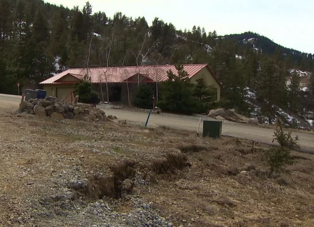
Chelan County landslide via KOMO News
.
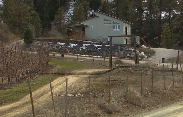
Chelan County landslide via KOMO News
.
The location of this landslide appears to be the area on the map below:
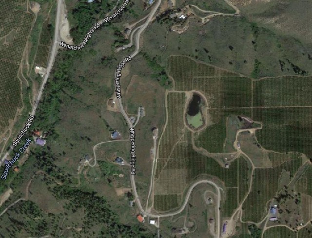
Chelan County landslide location
.
A Google Earth perspective view gives a better impression of the landscape in which this landslide has developed:
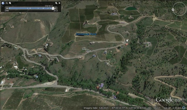
Chlean County landslide: a Google Earth perspective view
.
The news reports suggest that there is now a geotechnical investigation of this site to determine the causes of the landslide. Washington State is of course prone to landslides, and indeed on the image above there is a very prominent landslide scar on the left side, and hints of others too. But the immediate cause of this landslide is less obvious. The Google Earth imagery extends back to 1998. In the intervening time there have been some minor changes to this area, but nothing obviously sufficient to trigger the landslide. The two ponds higher up on the slope, for example, were both present in 1998.
17 March 2016
The Val Strem rockslide – a dramatic long run out landslide in Switzerland
Val Strem rockslide
The Val Strem rockslide occurred on Monday night in Canton Graunbunden in Swtizerland. This large rockslide appears to have had a dramatically long run out given its volume. There are a number of good reports about the landslide (in German) on the web, with some very high quality images. This one, via RTR, provides a nice overview of the landslide:
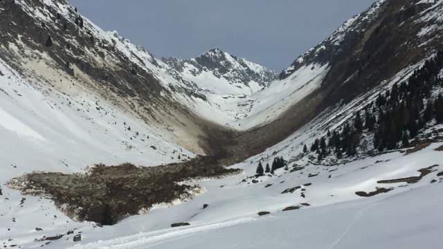
The Val Strem rockslide via RTR
.
There are a number of interesting features of this rockslide. The source of the collapse, which had a volume of about 200,000 cubic metres, was high on the valley wall on the right. The debris has slid down, super-elevated on the opposite valley wall, turned 90 degrees and then travelled down the main valley. Note the dust mantling the opposite valley wall. The landslide appears to have been very mobile (the estimated runout is about 1 km) – this is not really captured in the image above, but this one, also from RTR, shows it much more clearly:
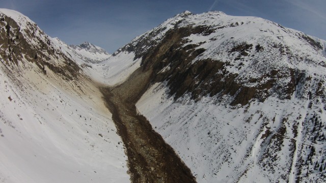
The Val Strem rockslide via RTR – detail of the runout
.
Reports suggest that the source of the rockslide, the Cuolm is da Vinci, was known to be unstable and had been monitored. It will be interesting to see what the data shows. The long runout might be explained by the fall onto a layer of snow, which might have provided a low friction surface. However, the snow depth does not look large to me, so I have some doubts about this. It could have been the effects of a frozen ground surface, but I suspect that a more important factor might be the constant valley gradient, which may have been sufficient to keep the debris moving. Interestingly, the landslide does appear to have been losing mass (depositing material) the whole way along its track. The image below, again from RTR, shows the upper part of the track in more detail – note the coarse material in the centre of the track, with finer grained material on the margins:
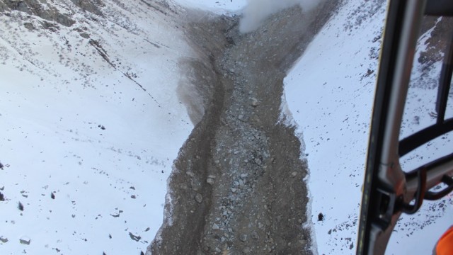
The Val Strem rockslide – detail of the track via RTR
.
Note the dust cloud from ongoing slides in the background. The Val Strem rockslide did not cause any loss of life or damage to property, but it has damaged the water supply the local communities and the inlets for a small hydro-electric plant.
15 March 2016
Bonne Nuit, Jersey: a strange place to build a new Care Home?
Bonne Nuit rockfall
There is a somewhat amazing story being covered on various media outlets at the moment about a cliff collapse at Bonne Nuit on the island of Jersey. The news reports suggest that a brand new Care Home, the Cheval Roc Nursing and Residential Home, opened on the top of a coastal cliff in February. This looks to be a most impressive place, with wonderful views. Unfortunately though, Jersey was affected by strong storms this weekend (just the most recent of a series of weather events that have affected northern Europe this winter) which appears to have triggered a significant cliff collapse event:
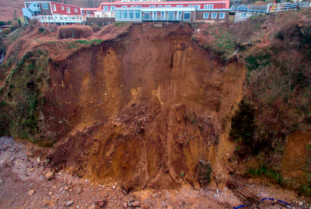
Bonne Nuit cliff collapse via Yahoo News
.
Inevitably the recriminations have begun, and one does wonder how a development was allowed on this site. The Jersey Evening Post is running a story about the planning process for this site (update – it turns out that this is another landslide in Jersey in the last few days):
Planning’s handling of the redevelopment of the former Hotel La Tour was criticised in the wake of the landslip by former Planning chief officer John Young, who was parish Deputy of the area from 2011 to 2014 and during which time he represented residents who were objecting to the development.
But the news story from the time did not focus on the coastal erosion problem:
Objectors had said that the development would dominate the area, result in a loss of privacy, and that the building works would result in a lot of disruption.
To me the morphology of the slopes at Bonne Nuit suggest that they are, and have been, quite active. I am not familiar with the geology of Jersey, but interestingly Wikipedia suggests that there is extensive loess and Head:
During the Quaternary Devensian glaciation, loess was deposited, blown in by wind from the west. The loess has formed thick deposits on the island interior and combined with periglacial frost shattered rock fragments sliding down the cliffs to form head which have themselves been eroded to form cliffs from 3 to 12 metres high. At Belcroute there is a more complex deposit of loess head on a raised beach deposit elevated at 8 metres, that sits on another loess deposit. Head occurs at the foot of cliffs along the north, north east and south west sides, and can also be found beneath wind blown sand at the bays of St. Ouen, St. Aubin, St. Clement and the Royal Bay of Grouville. The thickest parts of loess are five metres deep at St Clements and at La Hougue Bie on the eastern plateau
This is not a material that I would expect to be resistant to erosion. I wonder therefore why a new development was allowed so close to the cliff edge?
14 March 2016
Managing urban landslides
Managing urban landslides
On my last day in Kalimpong, Praful Rao of Save the Hills took me to visit an area of comparatively low wealth below the main town. This area, called Dumsi Pakha, provides a sad case study of the way that urban development in steep terrains can lead to landslide problems, with catastrophic outcomes for the inhabitants. This image gives an overview of the settlement, with large numbers of small houses sitting on the side of the steep hill. The challenge of managing urban landslides in such settings is clear:
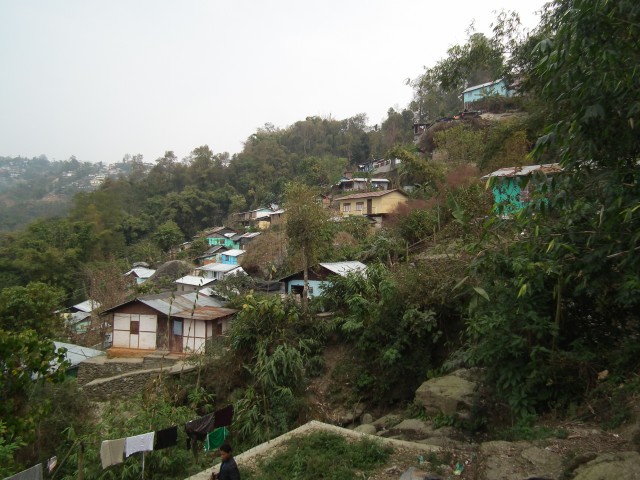
Managing urban landslides: an overview of Dumsi Pakha
.
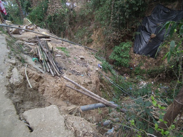
Landslides affect communities like this in multiple ways, but the two key elements that cause the problems are poor water management and slope disruption. As I noted in an earlier post in this sequence, water management in the town on the slopes above is a key factor. In Kalimpong town, water is discharged without any control into gulleys than run through Dumsi Pakha. This is one of those gulleys:
Managing urban landslides: a gully in Dumsi Pakha
.
The channel is of course dry towards the end of the dry season, and is choked with garbage. Note the extensive instability on the flanks of the channel in both the foreground and on the other side of the gully. This instability is being driven by the large flows that the channel now has to transport during the monsoon. These small landslides threaten many houses, whilst in some cases larger (but still not huge) slips are developing on the channel flanks. These have the potential to slip into the channel, briefly blocking it and then allowing a catastrophic debris flow to develop.
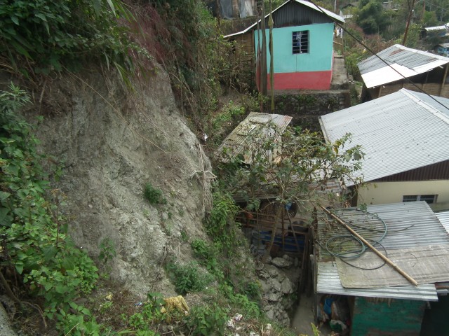
But elsewhere in the settlement the problems are more local. This house for example seems to have been built by first creating a bench by excavating into the slope:
Managing urban landslides: an unsupported cut slope in Dumsi Pakha
.
Note the boulders at the foot of the slope. This is a highly dangerous situation. It seems inevitable that this unsupported slope will, in time, collapse. There is a high chance that is in so doing it will cause severe damage to the house.
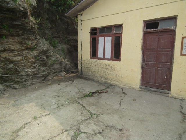
And then in other places there are cases of old landslides that have been reactivated by humans. This is the community centre, which was completed in 2002. There are very obvious signs of movement:
Managing urban landslides: the community centre at Dumsi Pakha
.
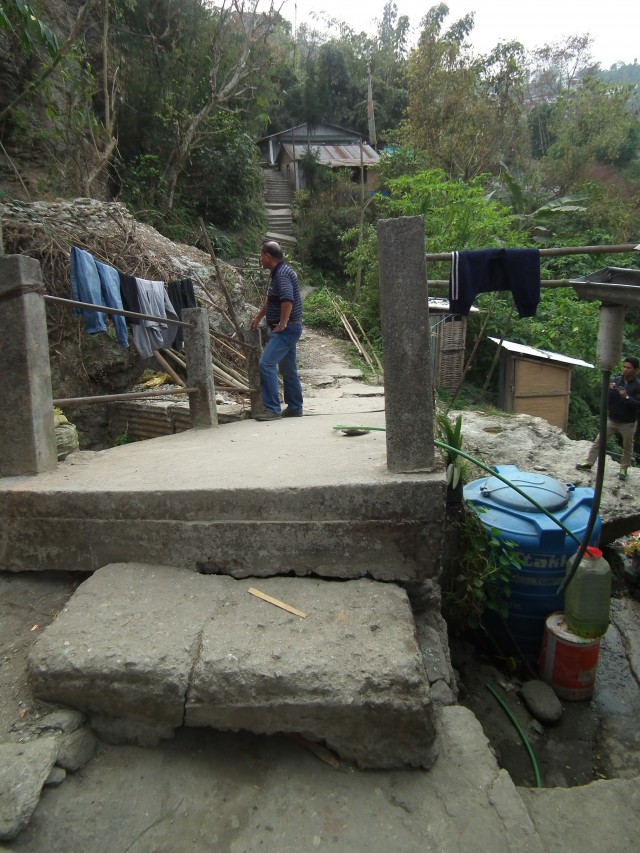
This deeper-seated movement is seen quite widely in Dumsi Pakha, although it is not ubiquitous. The clearest example is close to the community centre, where there is extensive movement occurring, bounded by the gully that I described above. The bridge across the gully is now extensively distorted, and the slope behind is moving quite extensively, as the steps behind Praful illustrate:
Managing urban landslides: extensive movement due to reactivattion of existing landslides
.
I think it is very important not to give the impression that the people living in Dumsi Pakha are passive victims of these problems. In many cases they are trying to manage the risk – for example they have built this retaining wall to try to stabilise a section of the slope that is particularly hazardous:
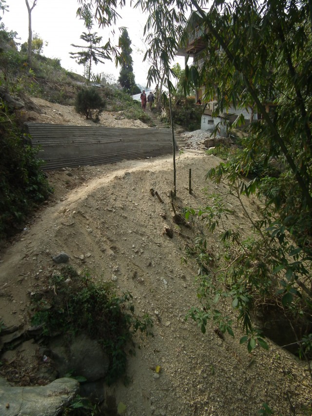
Managing urban landslides: a retaining wall constructed by local people
.
But the scale of the problems is so large that they cannot be solved alone. It is clear as to why people in these communities fear the monsoon so much; landslide accidents are inevitable in such settings without better management of the slopes. Dumsi Pakha is not exceptional or unusual – these types of problems are very commonplace.
12 March 2016
Nasty dancing rocks: boulders in Glenwood Canyon
Nasty dancing rocks
This video was apparently shot in Glenwood Canyon in Colorado in February 2016 by Heidi Swain. It is a great example of what is sometimes described as nasty dancing rocks – i.e. boulders rolling down steep slopes:
.
The manner in which some boulders start rotating and thus accelerate down the slope, with large bounces, is very apparent in the video, as is shown in this captured image:
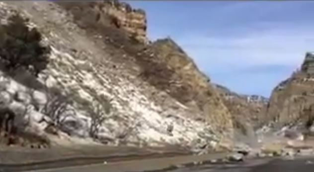
Nasty dancing rocks – a still from a Youtube video by Heidi Swain
8 March 2016
Kalimpong Day 4 part 1: An interesting and deadly roadside landslide
Kalimpong Day 4 part 1: An interesting and deadly roadside landslide
On Kalimpong Day 4, part of our UKIERI supported trip to the town of Kalimpong, I spent the morning with Major Joshi and colleagues from the Border Roads Organisation looking at a landslide on State Highway 31A, the road to Gangtok. This is a valley floor road, located on the banks of the Teesta River. Earlier this year there was a significant landslide on this road that killed two people and injured several others. Save the Hills covered this landslide in detail at the time – this is one of the images from their post. Note the truck precariously balanced close to the edge of the road.
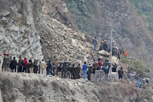
Image of the fatal landslide on State Highway 31A in January 2016. Courtesy of Save the Hills
.
The road is now clear but remains dangerous. This is an image of the site as of the time of my visit:
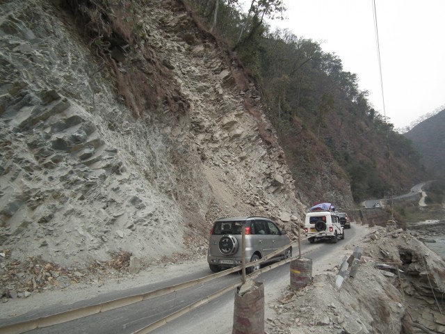
Kalimpong Day 4: The SH31A slope on the Teesta River
.
The source of the January 2016 landslide is located above the white 4×4. Beyond that is another unstable and obviously deformed mass that is waiting to fail. The risk to road users is very clear. This is a classic rock joint controlled instability; this image shows the joint pattern in the unstable rock mass:
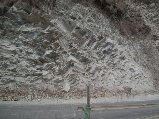
Kalimpong Day 4: Joints in the slope on State Highway 31A
.
There are two major joint sets visible, both steeply inclined. On the image one is diagonal from top right to bottom left, and the other top left to bottom right. These provide the surface to allow a wedge failure. The release surface is the foliation that forms the schistosity, which creates a surface that runs parallel to the road but dips steeply into the slope. This is best seen just to the left of the centre of the image, three quarters of the way up the slop. Here the two steeply dipping joints and the foliation have formed a classic wedge failure from which a block has detached, Once you have your eye in yo can see that these features occur all over the slope.
A little further along the slope this joint pattern changes, such that the instability in the slope is greatly reduced:
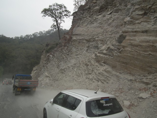
Kalimpong Day 4: Lower levels of instability with a more advantageous joint set
.
These do not look like large failures, and indeed they are not, but the force that they can exert is remarkable. This is the remains of an excavator that was caught in the January 2016 landslide. Note the damage to the boom and to the cab. The driver escaped:
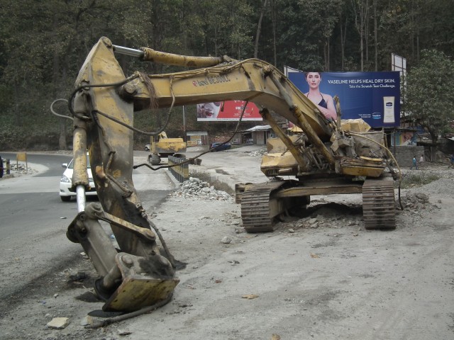
Kalimpong Day 4: Damage to an excavator associated with a landslide in January 2016
.
As the SW monsoon approaches, this slope is extremely hazardous. For non-technical reasons it does not seem possible to blast this rock mass to reduce the hazard, so the only option is to monitor it and close the road when instability is noted. This is not a trivial task. I suspect we will hear more about this slope in the months ahead.
6 March 2016
Kalimpong Day 3: the downstream effects of poor urban water management
Kalimpong Day 3: the downstream effects of poor urban water management
The town of Kalimpong sits on a ridge high above the valley floor. In common with many urban areas in poor countries (and sometimes in countries that are not poor too), water management is a serious problem, with a lack of sewers and storm drains. The upshot is that large volumes of water flow unregulated into natural channels during heavy rainfall, causing problems downstream. On Kalimpong Day 3, part of of our UKIERI / British Council supported visit, we saw a dramatic example of this issue. This gully lies a few kilometres downstream of the town. In living memory this was an area of paddy fields; now it has been eroded out and enlarged as the gully has had to handle greatly increased storm flows:
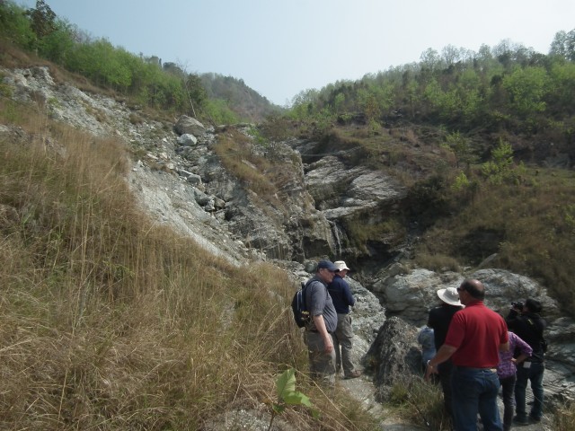
Kalimpong Day 3: members of the field party in front of a heavily eroded gully downstream from Kalimpong town
.
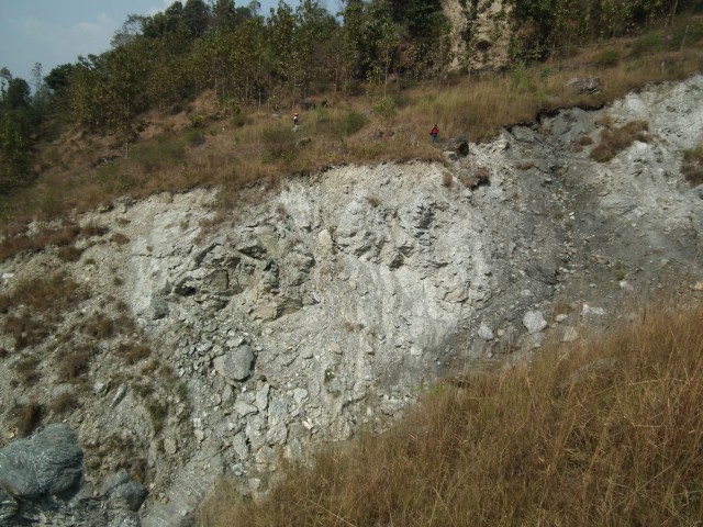
I suspect that the course of this gully follows an ancient landslide that was inactive until this gully enlarged. This image shows the walls of the gully – note the very heavily weathered and disturbed schist bedrock. The amount of erosion caused by the gully is very clear. Wing Commander Praful Rao from Save the Hills is standing at the top of the section for scale:
Kalimpong Day 3: erosion in a gully exposing an ancient landslide
.
Unfortunately the erosion in the gully is now triggering extensive landsliding. Immediately adjacent to the gully there slopes are actively deforming – sliding into the channel, which of course will cause further erosion. The path provides evidence of how bad this movement has become:
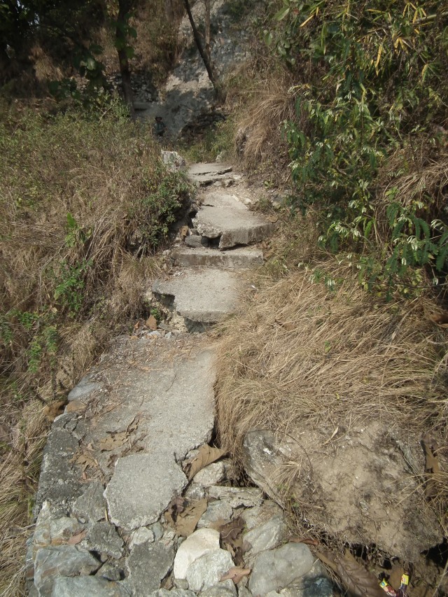
Kalimpong Day 3: Signs of serious instability in a footpath
.
This path is the access to a small community living on the other side of the gully from the road. Sadly, this community is also located on an ancient landslide that has also been reactivated by erosion in the gully. The effects on the houses are devastating:
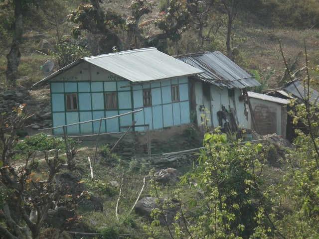
Kalimpong Day 3: landslide damage to a house
.
The damage to this house is not the fault of those living there, but is most likely the result of poor drainage in the town above. This problem is being exacerbated by a host of other things that are going on in this area. So, for example, at the top of the actively deforming slope with the path shown above, someone is dumping construction waste in an uncontrolled manner:
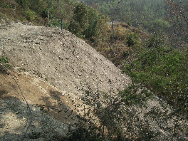
Kalimpong Day 3: uncontrolled dumping of construction waste on an active landslide
.
Adding a surcharge to the top of an active landslide in this way will inevitably make the stability problem worse. This sort of practice should be outlawed. Sadly, the effects of this dumping will be both further environmental damage and the destruction of the path that provides access to the community on the far side of the gully. This is all very preventable – there is a need for serious action to manage the slopes.
 Dave Petley is the Vice-Chancellor of the University of Hull in the United Kingdom. His blog provides commentary and analysis of landslide events occurring worldwide, including the landslides themselves, latest research, and conferences and meetings.
Recent Comments