8 January 2013
Increased occurrence of landslides in the UK in the last year – and the relationship to rainfall
Posted by Dave Petley
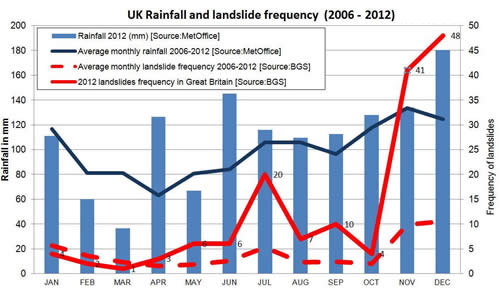
The British Geological Survey have posted a nice piece on their website about the increased occurrence of landslides in the UK in the last year. This includes the following graph, which shows rather well just what an extraordinary year 2012 has been, and in particular the increased occurrence of landslides in December:
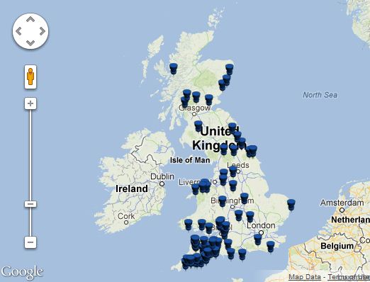
Interestingly, they also include a map of the landslides that have occurred around the UK in the last few weeks:
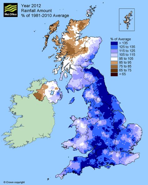
Note that there is a big cluster of landslides in Southwest England and then extending northwards to North Yorkshire, with a smaller number scattered around the rest of the country. It is interesting to compare this uneven landslide distribution with rainfall data. This is the Met Office rainfall anomaly map for 2012:
Note that this is variation from average rainfall – i.e. the dark blue areas had >135% of average rainfall for that area. The general pattern is clear – even if the fit is not perfect – in areas in which rainfall anomalies were hig for the year the occurrence of landslides was in general also high. Although this is unsurprising, it is a nice illustration of the ways that rainfall changes drive landslide triggering in the UK.


 Dave Petley is the Vice-Chancellor of the University of Hull in the United Kingdom. His blog provides commentary and analysis of landslide events occurring worldwide, including the landslides themselves, latest research, and conferences and meetings.
It is quite interesting to look at the response of the system to prolonged wet periods namely the three landslide frequency peaks in July, November and December. It seems that after the system responded to the initial large precipitation amounts in July, the continued above average wet period started disturbing areas (probably areas where previously there were no landslides) that eventually gave way during November and December.