7 December 2020
High resolution satellite imagery of the Mount Eagle peat slide
Posted by Dave Petley
High resolution satellite imagery of the Mount Eagle peat slide
In the middle of November two peat slides occurred in the Republic of Ireland, triggered by heavy rainfall. The slide at Mount Eagle received far less coverage than the landslide at Meenbog, but was nonetheless significant.
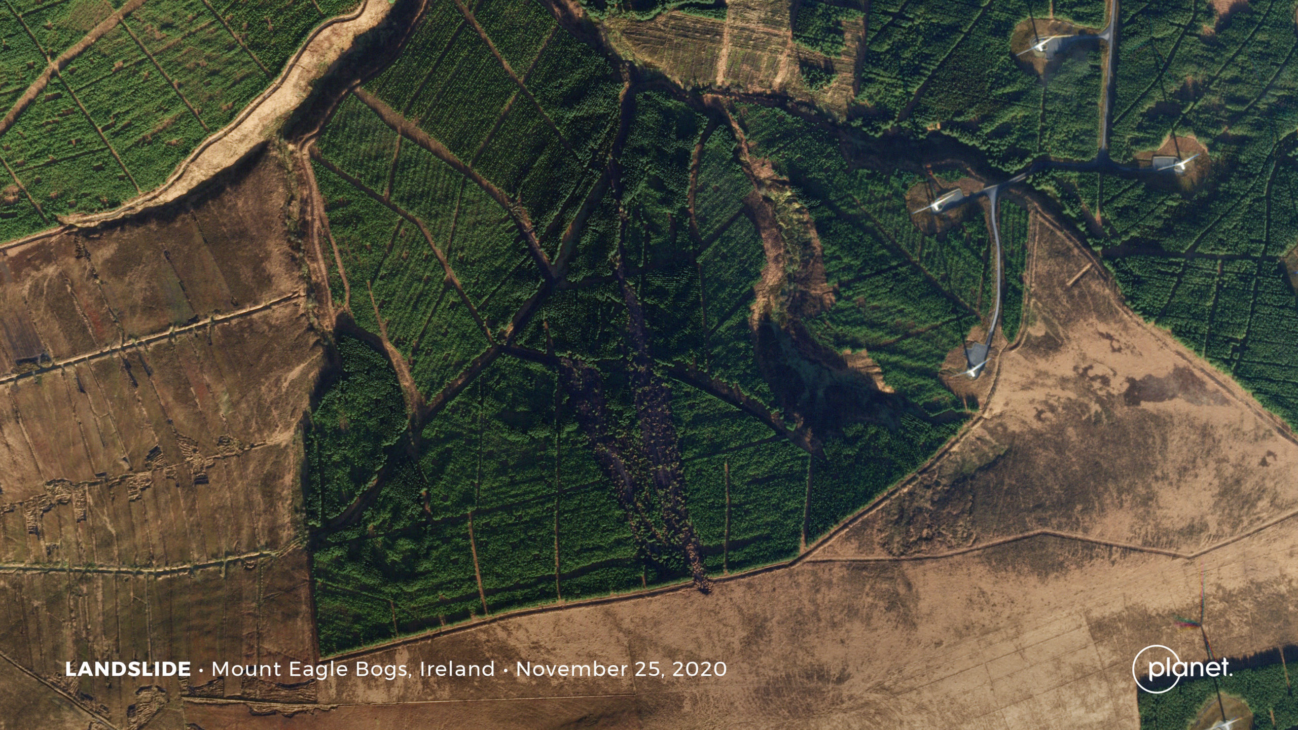
Planet Labs have very kindly captured high resolution satellite imagery of the Mount Eagle slide. This is not an easy area to image at this time of year as cloud coverage is high, but on 25 November they were successful. This is the image:-

The Mount Eagle Peat landslide. Planet Labs SkySat image, copyright Planet Labs, used with permission.
.
This image requires some explanation. High ground is to the south – the terrain slopes towards the north. On the east side of the image some wind turbines can be seen, but these are not apparently a factor in this landslide.
In the centre of the image there are two peat slides in the trees. The one to the west is an older failure – the timing is not clear but this slide is visible on Google Earth images. Immediately to the east is another peat slide – this is the one that occurred in November. It is larger then the earlier one. Interestingly the head scarps are very close together.
The November 2020 Mount Eagle peat slide appears to have retrogressed further than the earlier event, with the head scarp extending beyond the tree line and into the unforested area. Note that the blocks derived from the unforested area have travelled only a few metres, suggesting that this was late in the evolution of the landslide.
Between these two peat slides and the wind turbines to the east is a large, heavily eroded gully. I would speculate that this was another, much earlier landslide, but I have no further information.
.
Quickslide: AGU Fall landslide sessions
This week sees the start of the main landslide sessions at the AGU Fall Meeting. This is the schedule:
Monday, 7 December 2020
Poster: NH001 Debris Flows and Floods in Mountainous Terrain II Posters
10:30 – 11:30 EP007 The Influence of Landslides on Sediment Dynamics from Source to Sink I eLightning
20:30 – 21:30: NH006 Debris Flows and Floods in Mountainous Terrain I
Tuesday, 8 December 2020
Monday, 14 December 2020
Poster: NH027 Advances in Analysis and Prediction of Rockfalls, Rockslides, and Rock Avalanches II Posters
Poster:NH030 The Landslide Life Cycle: From Hazard Analysis to Risk Assessments III Posters
07:00 – 08:00: NH029 The Landslide Life Cycle: From Hazard Analysis to Risk Assessments I
08:30 – 09:30: NH031 The Landslide Life Cycle: From Hazard Analysis to Risk Assessments II
Tuesday, 15 December 2020
16:00 – 17:00: NH034 Advances in Analysis and Prediction of Rockfalls, Rockslides, and Rock Avalanches I eLightning
.
Reference and acknowledgement
Planet Team (2020). Planet Application Program Interface: In Space for Life on Earth. San Francisco, CA. https://www.planet.com/


 Dave Petley is the Vice-Chancellor of the University of Hull in the United Kingdom. His blog provides commentary and analysis of landslide events occurring worldwide, including the landslides themselves, latest research, and conferences and meetings.