15 October 2018
Sigi Biromaru: terrifying footage of lateral spreading during the Sulawesi earthquake
Posted by Dave Petley
Sigi Biromaru: terrifying footage of lateral spreading during the Sulawesi earthquake
Sigi Biromaru is a suburb of Palu located on the eastern side of the valley. Whilst most of the focus in the two weeks since the Sulawesi earthquake has been on the flowslides, it is easy to forget that other slopes also went through significant lateral spreading during the mainshock. In an initial (amazing) analysis of optical imagery collected by Sentinel-2, Sotiris Valkaniotis of the Aristotle University of Thessaloniki has shown that there was extensive lateral spreading on the eastern side of the fault. To confirm this, a video has been posted on Youtube that shows the development of very significant lateral spreading during the earthquake. In this case it appears that the lateral spreading did not transition into the type of flowslide seen elsewhere in Palu, but the level of damage is very substantial. The original video is available on Youtube:-
.
Unfortunately the camera is rotated, which makes watching the video quite challenging. There is another version that is easier to watch, albeit with an irritating backing track:
.
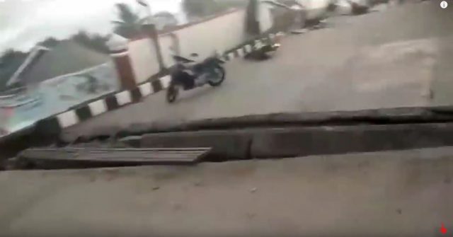
The astonishing thing about this video is that the lateral spreading, as indicated by the large tension cracks in the road, develops as the video runs. These two screenshots, taken less than a minute apart, show one of the fissures opening:-

Sigi Biromaru lateral spreading: one of the tension cracks starting to develop. Screenshot from a video posted to Youtube.
.
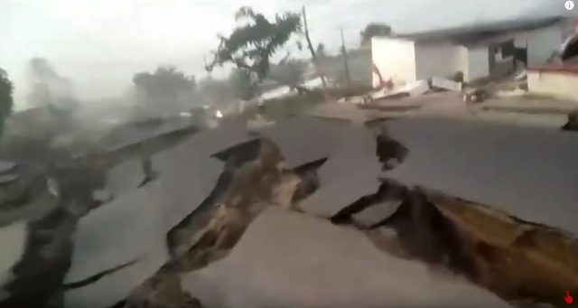
A few seconds later the fissure looked like this:-

Sigi Biromaru: the aftermath of the Sulawesi earthquake. Screenshot from a video posted to Youtube.
.
Fortunately in this case full liquefaction, if that is what occurred to generate the flowslides, did not occur. The magnitude of the damage is extraordinary though, illustrating the magnitude of the challenges that lie ahead in getting this area back on its feet:-

The aftermath of lateral spreading at Sigi Biromaru, after the Sulawesi earthquake. Screenshot from a video posted to Youtube.
.
In interesting element of this disaster will be understand why this slope did not go to the full, flowslide-generating failure seen at Balaroa and Petobo. It is very fortunate that this did not occur.


 Dave Petley is the Vice-Chancellor of the University of Hull in the United Kingdom. His blog provides commentary and analysis of landslide events occurring worldwide, including the landslides themselves, latest research, and conferences and meetings.
impressive!
I don’t see any water being expelled along the cracks as I would expect during conventional liquefaction. It would be very interesting to find the composition of the basal layer all this was moving on.
Digital Globe imagery released after this event shows the location of this video before and after the earthquake. You can see that it’s just at the headscarp of this slide… a few hundred meters further down, things really slid away https://twitter.com/TTremblingEarth/status/1049350252871012352
Is that tensional cracking and lateral spreading during a subduction earthquake from the motion of subsidence? Is this land moving along above the sliding subduction fault?
[This earthquake was shallow crustal strike-slip faulting, not subduction. The most likely explanation is lateral spreading that transitioned to flowslides in response to the intense seismic shaking. D.]