
8 September 2021
The Pretty Rocks landslide in Denali National Park in Alaska
Posted by Dave Petley
The Pretty Rocks landslide in Denali National Park in Alaska
Last year I posted about landslides in Denali National Park in Alaska, including a very interesting case study, the Pretty Rocks Landslide. This failure, located at 63.537, -149.815 if you wish to take a look, is heavily disrupting the single road through the national park. Time magazine has an online article about this landslide that is worth a look. Sitting behind that is considerable more detail on the Denali National Park website, including a set of images of the landslide:
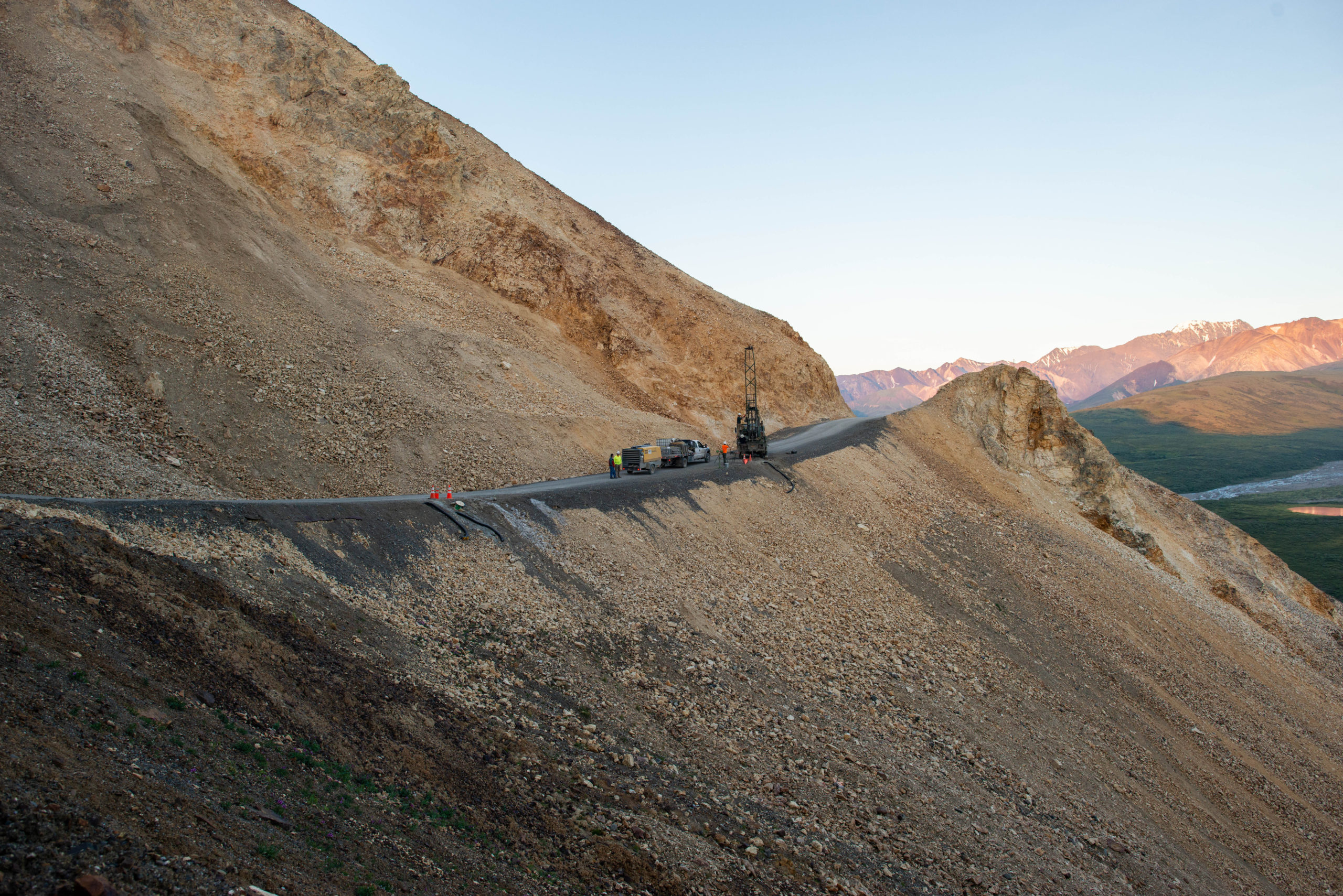
The Pretty Rocks landslide in Denali National Park. Image courtesy of Denali National Park.
.
The Denali National Park article notes that technically this is a rock glacier, and that it is moving quite rapidly. The rate of movement of the landslide has increased in recent years in response to the warming climate, with highttps://www.nps.gov/dena/learn/nature/pretty-rocks.htmh rates being noted in particular in periods of summer rainfall. The website describes the change in pattern of movement of the landslide:-
The landslide at Pretty Rocks has been active since at least the 1960s, but has evolved from a manageable maintenance concern into a much more extensive maintenance challenge. Before 2014, the landslide only caused small cracks in the road surface and required maintenance every 2-3 years.
Between 2016 and 2017, the full width of a 100-yard (90-m) section of road slumped up to 0.2” (0.5 cm) per day, steepening the road gradient and limiting sight lines for drivers approaching the sharp turn. but not warranting long-term closures.
However, by 2018 the slumping increased to almost half an inch per day, and then to three and a half inches per day by August 2020. Early August rains in 2021 appear to have triggered the rate to increase significantly, with much of the landslide currently moving downhill at over ten inches per day.
NPS road crews maintained a safe drivable surface for most of the summer of 2021 by importing as much as 100 dump-truck loads of gravel per week to fill the slump. On August 24, park managers recognized that this solution was no longer tenable or safe and enacted a road closure to the east of Pretty Rocks. As the area becomes more unstable, traditional road maintenance methods have become inadequate. The park’s ability to adapt to future conditions will require transitioning to more expensive and novel construction methods to maintain road-based access.
Denali National Park has produced a wonderful time lapse video of the landslide movement that is incredibly instructive:
Time lapse video of the Pretty Rocks landslide, produced by Denali National Park.
.
Note the continuous movement of the slide, wbich extends right to the toe of the slope. The dumping of gravel to maintain the road is clearly evident, as is the pitfall of this approach. The gravel is steadily loading the head of the landslide, increasing the driving force. Resistance is not increasing at the same rate, so the tipping is likely to be making the problems with the slope slightly worse.
The National Park are right to cease this approach. Unfortunately, as the National Park notes, alternative ways to maintain the road are likely to be costly and difficult.
 Dave Petley is the Vice-Chancellor of the University of Hull in the United Kingdom. His blog provides commentary and analysis of landslide events occurring worldwide, including the landslides themselves, latest research, and conferences and meetings.
Being interesteds in landslides and rock glaiers I took a look at this in Google earth (63.537, -149.815). But I can’t find anyrthing that is remotely like a rock glacier that looks like those that occur widely in the higher rnages of Alaska,
However, if you go (on Google Earth) to 63.538786,-149.816814)63.538786,-149.816814 and then follow a bearing of 186 degrees you do pass over a bulbous lobe that come right down to the river. This is a largelandslide toe, not a rock glacier. I’m developing a technque for mapping features as geomorphological transects on GE so the point above would be [63.538786,-149.816814] lat/lomhg in decimals with – being west, this gives about 1m resolution. The transect has {63.538786,-149.816814,186}. GE doesn’t go far back at this resolution but perhaps there are old images in USGS archives.
Brian, There can be honest disagreement about specific names for this feature, such as “rock glacier”. However, the overstepped toe that has been persistent in the landscape, indicating long-term internal deformation, and high ice content inside many parts of the Pretty Rocks feature are some of the characteristics that lead to thinking about this feature in terms of a permafrost type rock glacier. The ice content is known because of borings. Pretty Rocks may not fit perfectly into what some may consider the rock glacier paradigm, but it is better than the the alternative of not acknowledging the role of ice in this feature. Many different groups of people with many different backgrounds and expertise are working to maintain the Park road and understanding the roll of ice in the issue is important for that effort.
Brian, There can be honest disagreement about specific names for this feature, such as “rock glacier”. However, the overstepped toe that has been persistent in the landscape, indicating long-term internal deformation, and high ice content inside many parts of the Pretty Rocks feature are some of the characteristics that lead to thinking about this feature in terms of a permafrost type rock glacier. The ice content is known because of borings. Pretty Rocks may not fit perfectly into what some may consider the rock glacier paradigm, but it is better than the the alternative of not acknowledging the role of ice in this feature. Many different groups of people with many different backgrounds and expertise are working to maintain the Park road and understanding the roll of ice in the issue is important for that effort.
Hi Brian,
I have to second Eric’s comments. It took us years of struggling with an appropriate description to come up with “rock glacier”. It just did not fit into any of the classic landslide bins. However, once we had samples from multiple borings (including massive ice lenses), inclinometers, thermistor strings, and piezometers the answer became clearer. So, we got a rock glacier expert involved, they reviewed the data, and they agreed. Previously, when I thought about rock glaciers, I tended to think of the morphology of glaciers that had become rock glaciers. Certainly not the case here. After some research I realized that there is another variety that can have a very different morphology and that is the case at Pretty Rocks.
Classic! We have several old creeping slides on a US Highway 101 in Northern CA, and the legend is that several have 3 to 5 meters of asphalt. They are big logistics headaches because they are critical for access and the local economy.
Get the feeling only ‘fix’ is ‘Alpine snow-pack’: sink enough blast-holes to bring the lot down, clearing to bed-rock…
But, unsightly, and need a new rock-bench carving, with scary-tight bends…
Nik, we certainly have considered your solution and there will likely be some of that. Unfortunately, in places there is frozen volcanic ash below the rock glacier. So, even if we scrape/blast everything that is moving off, we still have to deal with a mess in the “bedrock”.
For the newest time lapse, including imagery through yesterday, see https://my.tikee.io/static_videos/b0383eb6-919b-40c5-bcce-f1b62052fc5e/public/deaf1659-9dc6-4e84-9ffc-d5a6af9b10c1
Maybe if they refrained from piling large volumes of fill onto it to maintain the road surface level . . .
(i.e. just let the road go)