12 July 2021
The cause of the Petobo landslide from the 28 September 2019 Palu-Donggala Indonesia earthquake
Posted by Dave Petley
The cause of the Petobo landslide from the 28 September 2019 Palu-Donggala Indonesia earthquake
Possibly the largest landslide-induced loss of life of the last few years was caused by the series of large liquefaction landslides triggered by the Mw=6.1 28 September 2019 Palu-Donggala Indonesia earthquake. I blogged about these events extensively at the time, and also noted that the GEER reconnaissance mission had provisionally suggested that the major cause might have been the presence of a series of canals high on the slopes.
A paper has recently been published in the journal Landslides (Kusumawardani et al. 2021 – you should be able to read the paper here) that examines one of the largest of these events, the landslide at Petobo in Palu. Just this landslide alone caused the destruction of about 3,300 houses and almost 2,000 people lost their lives.
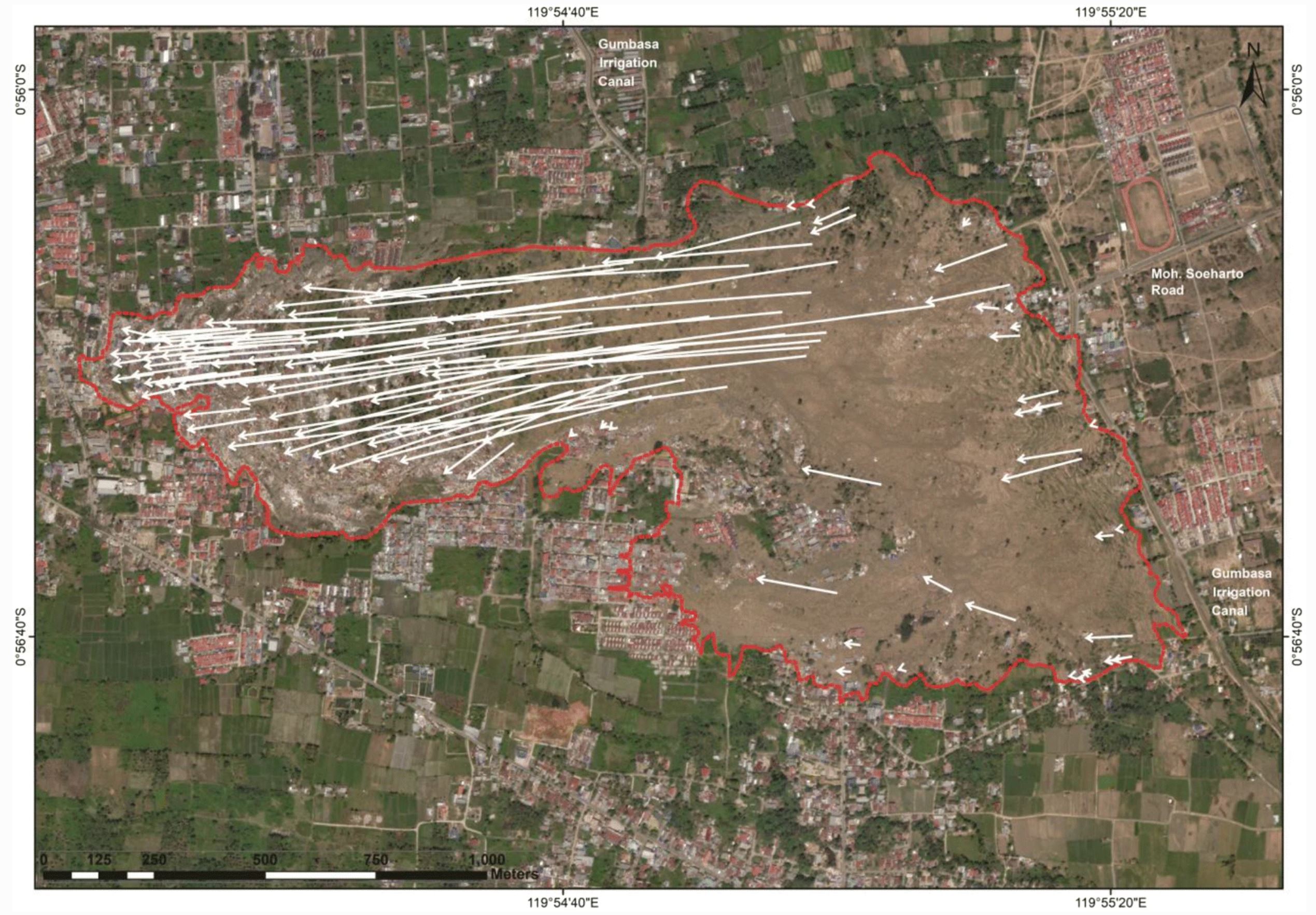
The paper is a detailed description arising from a site reconnaissance. It is a very valuable catalogue of the features observed, accompanied by a high quality interpretation of them. This, for example, is an interpretation of the movement vectors of the observed features on the ground. These are remarkable given that the average slope gradient is just 2°.

Movement vectors for the landslide at Petobo in Indonesia. Figure from Kusumawardani et al. (2021).
.
Kusumawardani et al. (2021) have revisited the issue of the cause of the Petobo landslide. They have considered carefully the role of the irrigation canal near to the crown of the landslide – note that this can be seen on the image above. The authors note that the unlined canal was constructed around 110 years ago. It had been upgraded through time but was unlined, and thus would have been charging the local groundwater levels. Prior to the earthquake the canal was full, and that it was being used to flood the local paddy fields to a depth of 30 to 50 cm.
Thus, Kusumawardani et al. (2021) have concluded that it is highly likely that the canal, and the resultant high groundwater levels and inundated paddy fields, led to a high level of susceptibility at Petobo to the effects of the earthquake.
An interesting aside is that the landslide was not rapid – the authors estimate that the rate of movement was in the order of 2.5 to 5 km/h, which is no more than a rapid walking pace.
An interesting question is whether this situation occurs in other earthquake prone areas in Indonesia.
.
Reference
Kusumawardani, R., Chang, M., Upomo, T.C. et al. 2021. Understanding of Petobo liquefaction flowslide by 2018.09.28 Palu-Donggala Indonesia earthquake based on site reconnaissance. Landslides https://doi.org/10.1007/s10346-021-01700-x


 Dave Petley is the Vice-Chancellor of the University of Hull in the United Kingdom. His blog provides commentary and analysis of landslide events occurring worldwide, including the landslides themselves, latest research, and conferences and meetings.
I wonder where the “warm water” cited in some of the witness reports came from. Possibly a frictional effect?