
16 November 2020
The Meenbog peat slide in the Republic of Ireland
Posted by Dave Petley
The Meenbog peat slide in the Republic of Ireland
There was a great deal of interest over the weekend in a peat slide that was caught on video at Meenbog in the Republic of Ireland. The landslide occurred on 13 November 2020. This is the video on Youtube:
.
The video is remarkable, showing rafts of bog with intact and upright trees sliding along a low angle slope. The peat blog landslide is large – as is so often the case with landslides in peat, the landslide has runout a very long distance, all the way to the major watercourse. There is an excellent drone video of the landslide track, also on Youtube:
.
The image below, a still from the video above, captures the upper part of the landslide:-
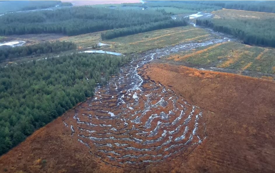
The upper part of the Meenbog peat landslide in the Republic of Ireland. Image captured from a video posted to Youtube.
.
The upper portion of the Meenbog peat landslide is an extensional zone, almost certainly caused by retrogression (uphill expansion) of the slide after the initial failure. It is possible that failure started towards the downslope end of this bowl. It is unlikely to be a coincidence that a ditch crosses the slope at this point. Downslope from the landslide becomes a channelised flow.
The landslide has occurred in an area in which construction is underway for the Meenbog wind farm, a project that has been controversial. According to the Irish News, “The wind farm is owned by global retail giant Amazon, which aims to have the site operational by 2022“.
I have written about peat landslides previously, most notably in relation to the broadly similar Dawn of Hope peat landslide earlier this year. Peat is a very strange geotechnical material, with very low density, low compressive strength but some strength in tension due to the fibrous nature of the material (which is how it can generate the rafts seen on low angled slopes). It generally has an exceptionally high water content. Once disturbed it has a very low shear strength, allowing long runout landslides to develop. Especial care is needed to avoid instability in areas of blanket peat coverage.
The trees involved are Sitka spruce. According to the USDA Forest Service, these trees have roots systems that are “shallow and platelike with long lateral roots with few branchings. On deep well-drained soils the root system may reach depths of 6.5 feet (2 m), especially on alluvial soils. Root grafting often occurs between roots of the same tree and adjacent trees”. This explains how trees can be involved in the rafts of the peat slide.
The threat of peat slides from wind farms is well-established – indeed in 2003 a major peat slide was triggered by the construction of a wind farm in Derrybrien. As the Galway Daily notes:
“The Irish State was found to be in breach of environmental safeguards during the construction phase of the project. On top of the €5 million lump sum which the Department of Housing, Planning and Local Government has confirmed as paid over, Ireland still faces daily fines of €15,000 until the situation is rectified.”
I find it hard to understand how this can happen again.
.
Quickslide 1: Hurricane Iota is heading for Central America
Quickslide 2: The anticipated landslide in West Dorset occurred on 15 November
On Friday in the Quickslide section I highlighted that a slope failure was developing near to West Bay in Dorset. This slope failed in the early morning of 15 November 2020.
 Dave Petley is the Vice-Chancellor of the University of Hull in the United Kingdom. His blog provides commentary and analysis of landslide events occurring worldwide, including the landslides themselves, latest research, and conferences and meetings.
The Meenbog failure looks like (another) bearing capacity failure under loading of the peat surface for construction of another length of access road. The point of failure is at 054 43 09 N, 007 52 24 W (261 m altitude). Note the treetrunks laid across the peat ahead of the gravel top layer at both sides of the failure. The initial failure appears to have released a body of extremely wet basal peat, giving rise to the characteristic ‘bogflow’ source area morphology. The total failure volume looks like around 20,000 cubic metres (maybe more if the peat is substantially deeper than 2 m within the source area).
This failure is only 3.8 km ESE of the large 1960 Barnesmore bogflow, parts of the source area of which can be seen in Google Earth at 054 44 18 N, 007 55 19 W.
this is very cool.
Alan provides one possible explanation of the trigger for the failure. A second scenario is failure of the stream margins further to the east where an existing forest drain joins the stream (this is visible on Google Earth using the forest rides as visual guides). The failure may then have retrogressed along the forest racks (rows) towards the track. The majority of these failures occur without construction influence and so a natural failure scenario should also be tested.
The eyewitness recording the trees moving in the first video would hopefully have a feel for whether the movement initiated away from the track and retrogressed across / in front of it, or whether the movement started at the track. With any luck, the post-failure report will shed further light on what happened.