
15 May 2020
A potential major rock slope failure above Barry Glacier in Alaska
Posted by Dave Petley
A potential major rock slope failure above Barry Glacier in Alaska
Yesterday, officials at the State of Alaska released a statement highlighting the risks of a major rock slope failure above the terminus of Barry Glacier in Alaska. This was prompted by a letter released by a group of scientists that highlighted the problem. The scientists’ statement starts:
We, a group of scientists with expertise in climate change, landslides, and tsunami hazards, have identified an unstable mountain slope above the toe of Barry Glacier in Barry Arm, 60 miles east of Anchorage, that has the potential to fail and generate a tsunami. This tsunami could impact areas frequented by tourists, fishing vessels, and hunters (potentially hundreds of people at one time). We believe that it is possible that this landslide-generated tsunami will happen within the next year, and likely within 20 years.
The statement from the State of Alaska notes that:
The threat of a large and potentially dangerous tsunami is looming in Prince William Sound, where an increasingly likely landslide could generate a wave
with devastating effects on fishermen and recreationalists using the area, the state’s top geologist said today.
The problem is a large, creeping rock slope that shows in the order of 185 m of deformation in some places. Failure of the slope could generate a tsunami in Harriman Fiord. The landslide is quite clear on Google Earth, although the image is now three years out of date. The location is 61.152°, -148.165°:-
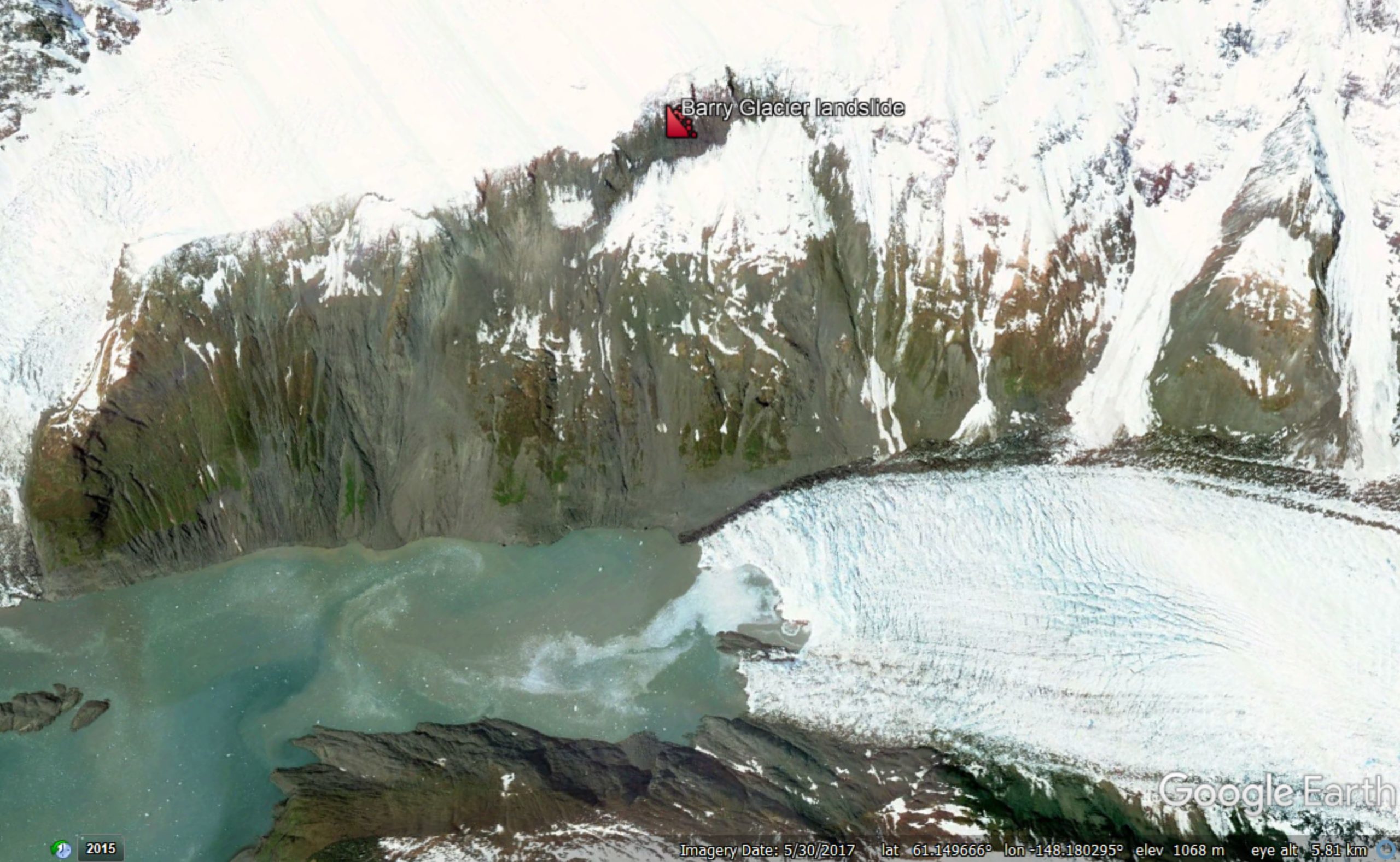
Google Earth image of the Barry Glacier landslide in Alaska. The marker shows the crown of the landslide – the scarp is evidence of the huge deformation that has already occurred on the slope.
.
This is a very large landslide – the scientific team estimate a volume of about 500 million cubic metres. Such large rock slope failures have a well documented track record of generating truly enormous local tsunami, with the Lituya Bay event in 1958 being the archetype of course. But, as I highlighted earlier this week, the behaviour of large rock masses is hard to anticipate.
In this case, there is an urgent need for monitoring, backed up by a detailed investigation of the landslide and its constituent materials. The science team has outlined an appropriate approach:-
To inform and refine hazard mitigation efforts, we would like to pursue several lines of investigation: Detect changes in the slope that might forewarn of a landslide, better understand what could trigger a landslide,and refine tsunami model projections. By mapping the landslide and nearby terrain, both above and below sea level, we can more accurately determine the basic physical dimensions of the landslide. This can be paired with GPS and seismic measurements made over time to see how the slope responds to changes in the glacier and to events like rainstorms and earthquakes. Field and satellite data can support near-real time hazard monitoring, while computer models of landslide and tsunami scenarios can help identify specific places that are most at risk.
The State of Alaska is taking this problem seriously. Its statement indicates that they will take a proactive approach:
The Division of Geological and Geophysical Surveys looks forward to cooperating with interested agencies and institutions to monitor the situation. One important step would be to monitor movement of land in the area by placing solar-powered GPS monitors on the potential landslide area to detect increased rates of movement that frequently precede catastrophic landslide failures.
The problem is being reported in the media in Alaska. Responding to these types of problems is challenging at the moment because of the Corona Virus crisis, but this does require attention. Failure is not inevitable, but the effects could be catastrophic.
.
On reflection 1: the 2019 fatal landslides database
Many thanks for those who have contacted me with corrections to the 2019 fatal landslide database. I’ll try to get a revised version online in the next few days and will highlight it here.
.
On reflection 2: Landslide problems in Kenya deepen
Kenya has been struggling for weeks with massive landslides caused by heavy rainfall. The problems have now deepened as a landslide has destroyed the water supply to the Kangemi slum on the outskirts of Nairobi. This is home to about 20,000 people.
Acknowledgement
Many thanks to Hig – Dr Bretwood Higman of Ground Truth Alaska – for keeping me updated about the Barry Glacier landslide.
 Dave Petley is the Vice-Chancellor of the University of Hull in the United Kingdom. His blog provides commentary and analysis of landslide events occurring worldwide, including the landslides themselves, latest research, and conferences and meetings.
The 1996 Google Earth image appears to show very little if any deformation….
A free, worthwhile aerial imagery tool is https://apps.sentinel-hub.com/sentinel-playground/
It only provides low resolution imagery, but many areas of the world are updated several times per week, with records going back several years. Very useful for tracking large-scale changes in landscapes or large construction/mining projects over time. It was shared with me by an exploration geologist who uses it to track snowpack changes while planning Canadian exploration programs.
If you zoom in on the notch in the toe of the ice you can see the splash from a rockfall!
Also it looks like another smaller failure to th3 left of the big one.
It is orders of magnitude bigger than Skand overhangs, but their ‘rule of thumb’, IIRC, is to monitor for a while, then evacuate area and demolish, per Alpine snow cornice removal…
61.140876°, -148.173698° looks pretty sketchy too.