
14 May 2020
The 2019 fatal landslide dataset
Posted by Dave Petley
The 2019 fatal landslide dataset
Yesterday I posted a map of the events in my fatal landslide dataset. In the post I provided the map as a diagram and as a dynamic Google Map that you can use to examine any given area. I posed the question as to whether it would be helpful if I made this data available online. The resounding reply was yes.
So, I have put the 2019 fatal landslide dataset into a Google Sheet (the equivalent of Excel) and have made this available. I summarised this data in a post a few weeks ago, although note that there have been some minor changes since then as I have refined the dataset. Such data is not static as I discover more events, or am able to provide better estimates. I should point out that the 2004-2017 dataset is available online as a GIS tool.
I have two motivations for posting this data:
- In the spirit of an age of open data I’m keen to share the information, and am eager for it to be used. I’m happy for it to be incorporated into research, to be exploited for teaching (especially now that we’re all having to teach largely online) and to be used by practitioners. I would ask only that you cite the two papers that I have listed at the foot of this post.
- I’m also keen to have corrections and/or additions. There are uncertainties in this sort of data, of course, and you may well understand better than do I as to whether I have recorded events correctly. I’m particularly concerned that I miss events in Latin America (most particularly in Central America and in countries such as Venezuela – see below), and I worry that I capture far fewer events in China than was the case in the past.
If people are able to provide corrections then I will make the improved data available. The Google Sheet itself is locked (i.e. you cannot change the online data).
The spreadsheet should be straightforward. I should explain a few columns:
Column d: this is the pentad data that I sometimes use to plot graphs. It divides the year into 73 blocks of five days, so that pentad 1 is 1 to 5 January, pentad 2 is 6 to 10 January, etc. Plotting data like this makes it much easier to compare between years
Column j: this is an estimate of the accuracy of the location data, suing the code given at the top of the spreadsheet. You will see that for a small number of locations I do not have sufficient information to plot a meaning location.
Columns o and p: I separate fatalities and injuries from landslides triggered by earthquakes from those from other causes, simply to ease the analysis of the data.
Column q: This is the cumulative number of landslide fatalities for the year, excluding events triggered by earthquakes
Column r: This is the cumulative number of landslide events for the year, excluding events triggered by earthquakes
Column t: Sometimes reports identify a primary trigger for the event (recorded in column s) but also a secondary factor (recorded in column t).
The data does allow you to do some quite cool stuff, such as demonstrate that it is the western (mountainous) side of Colombia that is affected by landslides, but it also asks the question as to whether I am missing similar events in in Venezuela and Ecuador?
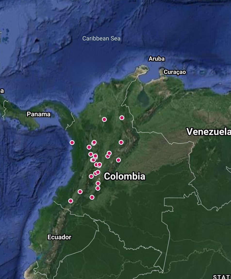
The distribution of landslides in Colombia in the 2019 fatal landslide dataset.
As always I welcome your thoughts.
.
On reflection
A rather spectacular bridge failure has been induced by a landslide at Cinyiru in Banten Province in Indonesia. The report suggests that “We have dispatched a backhoe and construction workers to repair the bridge, so that cars can again ply on it.” I think that is quite optimistic:-
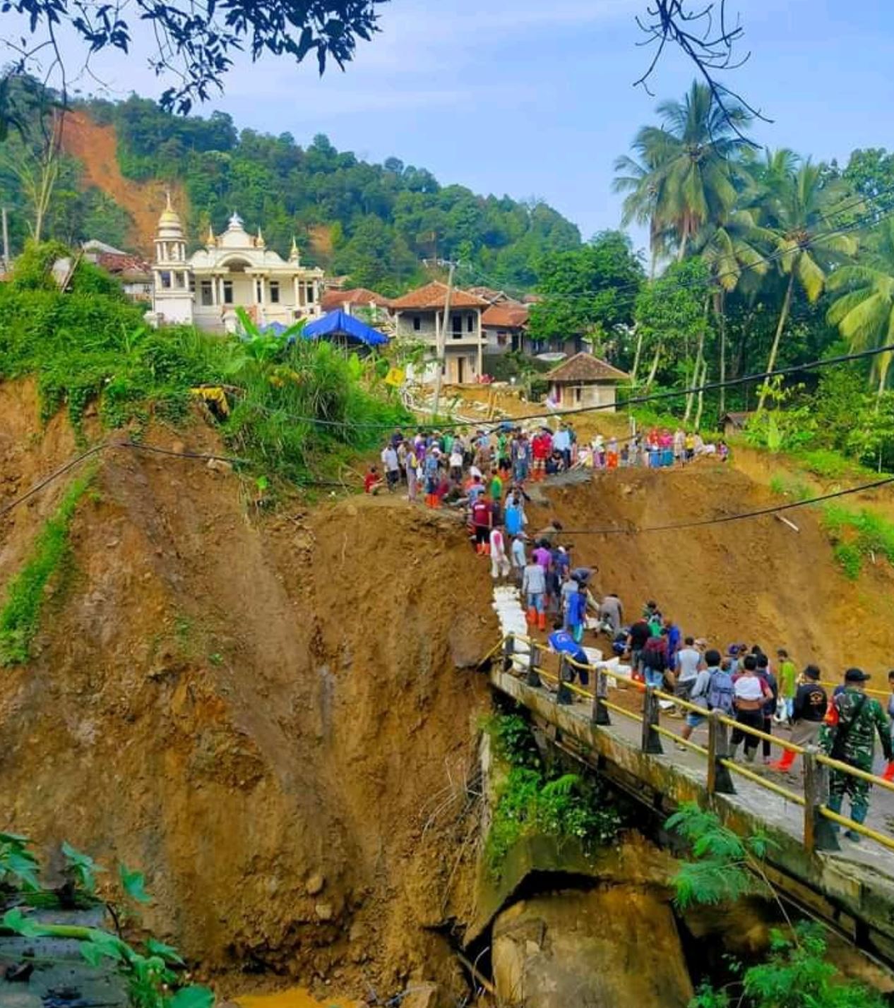
A landslide in Cinyiru, Indonesia, via Twitter. Note the landslides behind the village.
.
References
Froude, M. J. and Petley, D. N. 2018. Global fatal landslide occurrence from 2004 to 2016. Natural Hazards and Earth System Science, 18, 2161-2181, https://doi.org/10.5194/nhess-18-2161-2018.
Petley, D.N. 2012. Global patterns of loss of life from landslides. Geology 40 (10), 927-930.
 Dave Petley is the Vice-Chancellor of the University of Hull in the United Kingdom. His blog provides commentary and analysis of landslide events occurring worldwide, including the landslides themselves, latest research, and conferences and meetings.
Hi Dave, I’ve tried on a few different devices and the map link is not working, get the Google 400 error. Perhaps it’s something on my end but passing along in any event. Cheers for the excellent dataset.
[Thank you. This is usually a cookie problem on Google Chrome. If anyone is suffering from this problem, try a different browser or view the map in incognito mode. D.]
These are points, correct? I teach GiS and would be interested in creating polygons from them to get area and even volume. Thanks for posting this data.
[Yes they are points. In almost every case there is not enough information to track down the actual location, or to map the surface area or determine the volume. D]
Hi Dave, Do you have the fatal landslide events for 2018?
Thank you in advance for your reply.