
11 February 2020
A seismic analysis of the 23 July 2019 Shuicheng landslide in China
Posted by Dave Petley
A seismic analysis of the 23 July 2019 Shuicheng landslide in China
On 23 July 2019 a large landslide occurred at Pingdi in Shuicheng County in western Guizhou Province, China, killing 51 people. I covered this large landslide, one of the more significant of 2019, at the time, and in August 2019 I posted the following high-resolution Planet Labs image of the slide:-
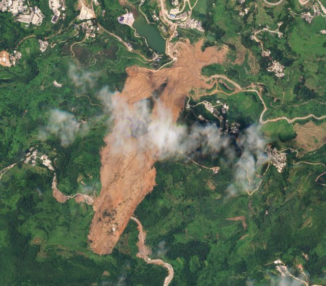
A Planet Labs SkySat image of the Shuicheng landslide in Guizhou Province China. Image collected on 2nd August 2019, copyright Planet Labs, used with permission.
.
A first analysis of the Shuicheng landslide (Yan et al. 2020) has now been published in the journal Landslides. The most interesting element of this piece of work is that it uses a very detailed analysis of the seismic signals generated by the landslide to interpret its behaviour. This is one of the most detailed analyses of this type to date. It is particularly intriguing because of the behaviour of the slide, which I highlighted at the time, with an initial planar sliding component (in the vicinity of the road at the top of the slope, which is the bottom of the image above), bifurcation into two components in the middle part of the track, and then a single runout zone. Interestingly, Yan et al. (2020) have been able to back-analyse this behaviour from the seismic data.
As a consequence of this investigation, the authors have provided this schematic of the behaviour of the Shiucheng landslide:-
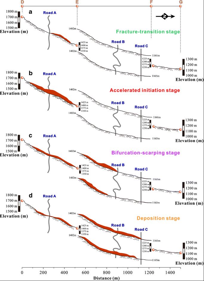
Schematic diagram showing the behaviour of the Shuicheng landslide, as interpreted from the seismic data by Yan et al. (2020).
.
To my surprise, the data suggests that the Shuicheng landslide started below the road (Road A), not on the upslope side. Yan et al. (2020) suggest that this might have been the result of saturation of this part of the slope due to runoff from the road. This initial landslide was small, but it soon destabilised a wider area, such that a larger mass in the crown of the landslide began to move. Failure of this upper portion of the slope remained slow, but as the mass loaded the steeper slope below, the landslide both accelerated and increased in volume as material was entrained.
In the third stage of the Shuicheng landslide, the natural topography forced it to bifurcate into the two portions seen in the satellite image. The landslide was now rapid and was efficient in entraining debris.
Finally, the mass reached the bottom of the slope and was deposited in the valley. The seismic data indicates a rapid deceleration once the topography no longer supported sliding.
In my original posts I hypothesised that the road had destabilised the slope, but my interpretation was that it would have been the section upslope of the road that failed first. Yan et al. (2020), using quantitative data, have shown that whilst the road was indeed a key factor, it was the downhill portion that failed first.
This is a really nice example of the ways in which these new quantitative datasets can provide insight into landslide mechanisms.
Reference and acknowledgement
Yan, Y., Cui, Y., Tian, X. et al. 2020. Seismic signal recognition and interpretation of the 2019 “7.23” Shuicheng landslide by seismogram stations. Landslides. https://doi.org/10.1007/s10346-020-01358-x
Planet Team (2020). Planet Application Program Interface: In Space for Life on Earth. San Francisco, CA. https://www.planet.com/
 Dave Petley is the Vice-Chancellor of the University of Hull in the United Kingdom. His blog provides commentary and analysis of landslide events occurring worldwide, including the landslides themselves, latest research, and conferences and meetings.
Dear Professor Dave Petley,
Thank you very much for sharing and commenting on this article. Our team has recently done a lot of research on the reconstruction hazards process of seismic signals. Hope to have the opportunity to share and discuss this research with you.
Best wishes,
Yan Yan
Dear Prof. Petley, thanks a lot for sharing the A seismic analysis of the 23 July 2019 Shuicheng landslide in China. Recently, I paid attention on this unusual landslide event by gathering information from web.
From traditional geotechnical engineering point of view, road construction and excavation on the slope toe will subsequently reduce the slope stability. According to the site investigation after Shuicheng landslide (Li et al., 2020), Road A is located in the landslide source area, the average depth of the slide surface is about 20 m. Since I found that the vegetation and houses in the source area remained relatively well positioned after sliding, and the original terrain platform disappeared after the slide, so I concluded that the area was sliding, with limited movement distance.
If the toe of the surface of rupture exit above Road A, it will not form such a deep slip surface and such a large destabilization body, and the sliding source area will not maintain such an integrity. Therefore, I deducted that the toe of the surface of rupture of the landslide is blow the Road A. Based on the comparison of field investigation and historical Digital Elevation Model, Guo et al. (2020) reconstructed the motion of the landslide with numerical simulation using nonlinear shallow water equation, which predict the actual pattern and volume. Compared with Yan et al. 2020’s results, the numerical simulation results somehow match the seismic analysis and we concluded that the influence of Road A on the initiation of landslide is limited, but cannot be ignored. The effect of surface runoff and internal erosion during the rainfall process which may be the direct cause of the Shuicheng landslide, but still need further experimental and numerical verification.
Reference
Guo J, Yi SJ, Yin YZ, Cui YF, Qin MY, Li TL, Wang CY (2020) The effect of topography on landslide kinematics: a case study of the Jichang town landslide in Guizhou. China. Landslides. https://doi.org/10.1007/s10346-019-01339-9
Li, H., Xu, Y., Zhou, J. et al. 2020. Preliminary analyses of a catastrophic landslide occurred on July 23, 2019, in Guizhou Province, China. Landslides. https://doi.org/10.1007/s10346-019-01334-0
It’s a great source of knowledge; I think it will be helpful for lot of people who are looking for learning more about the seismic analysis… Thank you very much for sharing this article, looking forward for more on this page. Come across Bvtengineering.com and hope you can visit this too to get more information.
earthquake engineering