8 March 2019
Hooskanadan Landslide in Oregon – an update on the Highway 101 earthflow near to Brookings
Posted by Dave Petley
Hooskanadan Landslide in Oregon – an update on the Highway 101 earthflow near to Brookings
Reports in the last few hours suggest that Highway 101 near to Brookings in Oregon might reopen on Saturday, following its closure as a result of the major Hooskanadan landslide. Tideway Contractors have focused on constructing an initial unpaved route across the landslide body, with ramps of suitable grade, to allow a single vehicle lane to be established in the first instance. The challenge has been that the landslide has continued to move during this process. Early in the reinstatement process the landslide was moving at an estimated 2 feet (60 cm) per hour, but during the week this was reported to have declined to 6 inches (15 cm) per hour.
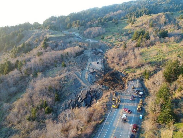
This image, from 11 KCBY, shows the magnitude of the movement at Hooskanaden Creek, and the challenges in reinstating the road:-

The displacement of US101 by the Hooskanadan landslide, north of Brookings. Image via 11 KCBY, ODOT and Tidewater Contractors.
.
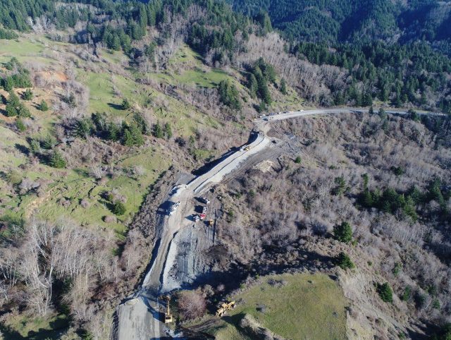
The irony is of course that in emplacing fill on the landslide to create an appropriate grade, the contractors may have loaded the unstable portion of the slope, making movement slightly more likely. Unfortunately, in this type of situation it is the only realistic option, and it is an accepted management approach. The extent to which this has been necessary is better illustrated by this image, tweeted in the last few hours, showing the works from the other side:-

The extent of the earthworks on the Hooskanadan Landslide affecting Highway 101 north of Brooking in Oregon. Image tweeted by Tidewater Contractors
.
Regular correspondent funkenbeachin has pointed out to me some hydrograph data from Smith River, not far from the landslide, provided by the USGS. This seems to suggest a recent period of reasonably heavy rainfall, but conditions that are not particularly exceptional. There is no doubt that this slide will move again in the future, but the costs of permanent stabilisation are unlikely to be justifiable. The only realistic option is often to rebuild the road each time, and to accept the cost and inconvenience.


 Dave Petley is the Vice-Chancellor of the University of Hull in the United Kingdom. His blog provides commentary and analysis of landslide events occurring worldwide, including the landslides themselves, latest research, and conferences and meetings.
Dave — You might be interested in PRISM Climate Group, which just happens to be based in Oregon (http://prism.oregonstate.edu/explorer/). Their data covers the entire continental US and I’ve found it to be a very nice compliment to the USGS stream gauging stations.
According to the model, the interpolated precipitation in February at this exact location was about 24 inches. That’s roughly 14 inches higher than average for the month. There was also an apparent event of about 9 inches occurring on February 24-25. Possibly the trigger?
Here is a good video of the site.
https://www.youtube.com/watch?v=edkt7-dxELY
“The only realistic option is often to rebuild the road each time, and to accept the cost and inconvenience”
Absolutely. This earthflow has been moving like an escalator down the hill for many decades. Earlier photos taken after the recent episode showed several generations of pavement below the current, pre-failure alignment.
This information is totally unofficial. But local word of mouth (Rumor) is that the single lane is for heavy trucks. Logging is a major industry and the detour route is narrow and is, itself, subject to slides. Log trucks are already taking a toll on the detour. This area received 12-18 inches (12.5 to 45.7 cm) over 10 days. The nearest river is the Chetco.
Why not a viaduct OVER the landslide so it can freely move UNDER the road?
There are several “large” and “old” slides across the west coast and smaller active areas in Appalachia — where recurring events, or new activity only yards or a mile or so away, are causing considerable expense, commercial loss, inconvenience, and death. One death, or numbers that raise a call to action or change — are the same …
We have an array of tools, across the monitoring sectors … sub-surface, surficial, spaceborne — that allow for the collection of significant amounts of data — many in a non-contact/destructive manner. Costs of data collection continue to fall and the quality and availability of the same increase consistently.
We are at a nexus of proactive consideration, monitoring, management, planning, budgeting / react, remove, replace, repair …. and the our “practice” firmly supports the latter. Technology is a tool that allows us to engage, assess, and address problems in new ways, in ways that can create long -term change, and allow us to safely manage events and occurrences where we could never, before.
The human factor remains our greatest challenge, and opportunity. How to harness the array of tools, the collective experience, and vision — to embark on a new path, a different one, where the integration and alignment of effort are powerful enough to make a significant change in route, direction … and result…this drives us forward each day….
Like most wet land slides the water is actually coming from up-slope. County GIS lidar shows a large depression in the hillside directly up-slope. Improving the catchment (depression) area to allow a diverting of the current subterranean water from subterranean to surface water from the catchment (depression) into a culvert or creek then culverts under the road would reduce the level of subterranean saturation. Further subterranean water catchment and transit in the up-slope area above the road would keep the slope from re-saturating in the wet season. Similarly down slope could be drained to tye base of the slope and stabilized with large boulders to provide saturation resistant geostucture to support the roadway structure and road bed. How much rock went into the Harbor pit a few years ago? The road closure is more than an inconvenience for our coastal residents . It is an economic disaster.
Rob, what you are stating makes a lot of sense. SatSAR data shows the ongoing change year on year — not sure anyone looks at that…monthly cost for 24-day differential reports would be about 5-7K a month…and long term contracts usually bring that down. Couple with available precipitation info or free regional views from (https://twitter.com/NASARain) … would make for great actionable intelligence ….