22 October 2018
Yarlung Tsangpo: a large valley blocking landslide in Tibet
Posted by Dave Petley
Yarlung Tsangpo: a large valley blocking landslide in Tibet
Xinhua reports that on Wednesday of last week (17th October 2018), a very large landslide occurred in Menling County in Tibet, blocking the Yarlung Tsangpo River. The volume of the barrier lake quickly increased, reaching a reported 300 million m³, and thus presenting a substantial hazard. Interestingly, this is the second barrier lake to form in Tibet in a short period, as on 11th October 2018 a further large, valley blocking landslide occurred at Bolo township in Jomda County, also causing a substantial blockage. To have two large valley-blocking slides in such a short period of time is quite surprising.
In the case of the Yarlung Tsangpao landslide, SANDRP reports that the location is in the vicinity of 94.9375° E, 29.7496° N, although it recognises that there is some uncertainty in this position. Unfortunately at present there is too much cloud in the area to validate this with satellite imagery.
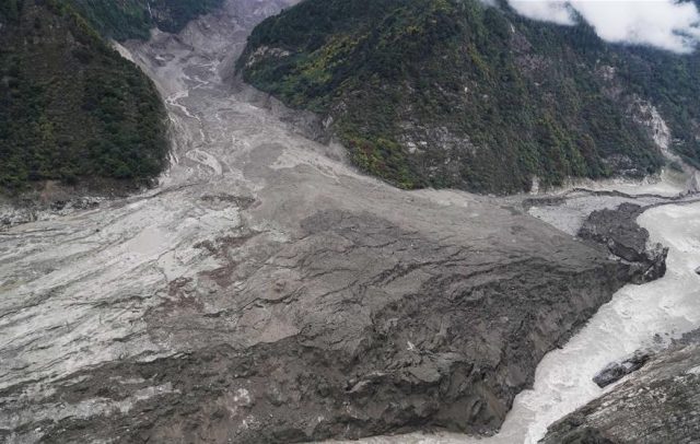
Xinhua has this view of the landslide barrier:-

The landslide blocking the Yarlung Tsangpo river in Tibet. Image via Xinhua.
.
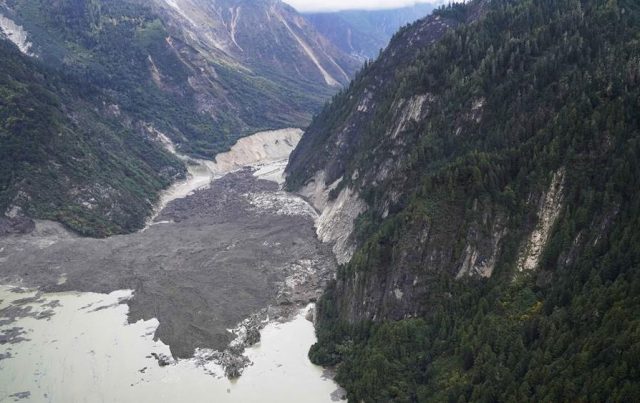
Initially the landslide caused a complete blockage of the Yarlung Tsangpo river, but the blockage has now breached. There is some evidence that the overtopping event caused flood damage downstream, but prompt evacuation of the downstream communities appears to have ensured that no lives were lost. This image, also from Xinhua, shows the blockage prior to overtopping:-

The valley-blocking landslide on the Yarlung Tsangpo river in Tiber. Image via Xinhua,
.
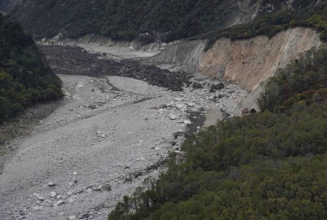
This Xinhua image is particularly interesting, showing the very lower reaches of the landslide deposit and the dried out riverbed:-

The toe of the landslide at Yarlung Tsango in Tibet. Image via Xinhua.
.
SANDRP quotes a researcher in the area as indicating that this landslide might have been a glacial surge:-
“A researcher who alerted India about the landslides along Yarlung Tsagpo in Dec 2017 said that the Sendapu glacier surged and wasted between September & 13th October, releasing debris that possibly led to the landslide.”
Some sort of glacial event, possibly a rock and ice avalanche that flowed across the glacier surface, akin to the Siachen Glacier event in Pakistan in 2012, appears to have been the cause. We will need satellite imagery to know for certain.


 Dave Petley is the Vice-Chancellor of the University of Hull in the United Kingdom. His blog provides commentary and analysis of landslide events occurring worldwide, including the landslides themselves, latest research, and conferences and meetings.
Please read
https://twitter.com/rajfortyseven/status/1054712822477709312
for correct & exact location of the block with satellite imagery analysis.
https://theprint.in/governance/brahmaputra-flood-scare-in-arunachal-over-but-india-must-watch-out-as-crisis-can-return/138639/
Wonder as to why China provided the exaggerated information to India only after the crisis was effectively over.
Hello Dave,
thanks for the article. Are there papers/literature that allow a classification of different glacial events? for example, what constitutes a glacial surges as against a rock avalanche, vs a landslide.
thanks
What was the triggering factor for such a large landslide.
Read about latest situationa at Gyala barrier dam on Yarlong Tsangpo or Brahmaputra.
https://theprint.in/security/enormous-debris-from-landslide-heading-towards-arunachal-with-brahmaputra-waters/144942/
It is dangerous!