
1 November 2011
Intriguing landslide of the week – catastrophic bluff collapse at WE Energies plant at Oak Creek in Wisconsin
Posted by Dave Petley
Summary: An initial report of a landslide that occurred yesterday at the WE Energies electricity generating station in Wisconsin, USA. Some thoughts on possible causes are included.
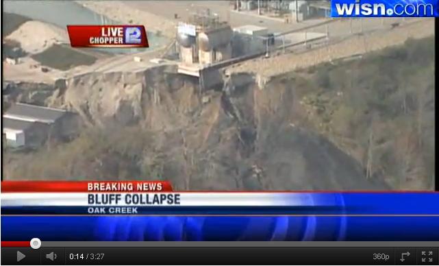
In Wisconsin yesterday a landslide occurred at the WE Energies power station complex near to Oak Creek in southern Wisconsin. This is the site, which is located on the western edge of Lake Michigan:
The landslide has occurred on the southern side of the complex in an area that is being developed for pollution control equipment (presumably sulphur scrubbers or suchlike). It appears to be a fairly mobile flow slide that covered an area that is reported to be “the size of a football field”:
http://www.nctimes.com/news/national/article_576a7846-ce5a-5f77-95bd-e34e5e8ddefc.html
The image above shows the landslide quite well, but the youtube video below, which has news helicopter footage (and some rather excitable commentary, shows it rather better, and includes some close up imagery of the slide:
There is a great deal of speculation in the media about the causes given that the weather conditions were dry at the time of the landslide, and the area is in rainfall deficit over the last month. I do not know the cause, but would make the following observations that may be pertinent:
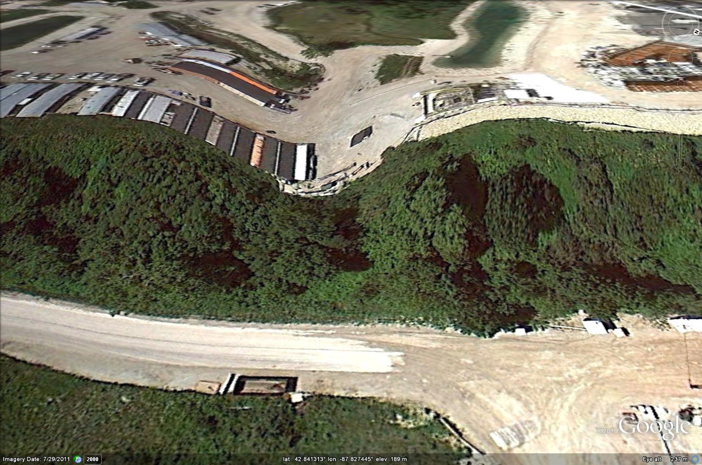
1. The landslide occurred at the site of what was a topographic dip (probably an old channel of some sort). The Google Earth image below shows the are before the recent works were commenced (it is dated 2007):
This is clear also from the aerial view, but the area has been paved over and is partially covered with trailers or shipping containers:
A perspective view which uses the digital elevation model from the time before the works were carried out (i.e. the topography might not be correct – see below), shows this:
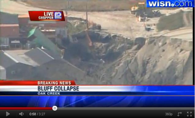
2. It seems likely that to create this parking area this topographic dip was partially filled. This still from the helicopter footage is really interesting:
Note two things here – first, there is a sheet pile wall (see below) that appears to truncate near to the edge of the landslide. Second, it appears that there is fill behind the wall that has partially collapsed.
3. The depth of the retaining wall is les than that of the slide; The image above shows that the retaining wall does not reach the basal shear surface of the landslide. As such ist would provide little or no protection against the slip. It is interesting that in this news report the spokesman for the site described the slide as an “embankment”.
4. There is a pond very close to the crown of the landslide. I am not sure what this pond is for (I am no expect on power plants), but IF there was a leak then the slide had a ready supply of water. I would want to check the integrity of the liner.
5. The materials in the slide look strange. Most notably, they are very dark grey / black, which does not seem to match the materials in the source area. It could be an optical illusion, but they seem to match the colour and consistence of lake silts/clays or wet ash. I wonder what material might have been used to fill behind the retaining wall (update – as I was trying to hint here, it seems likely that this is ash).
People located closer to the site might have further insights – comments very welcome!
 Dave Petley is the Vice-Chancellor of the University of Hull in the United Kingdom. His blog provides commentary and analysis of landslide events occurring worldwide, including the landslides themselves, latest research, and conferences and meetings.
The black color, I assume, is because of the coal ash.
http://www.jsonline.com/news/milwaukee/authorities-investigate-bluff-collapse-at-we-energies-plant-132929538.html
The plant is actually on the western edge of Lake Michigan, not Lake Wisconsin [thanks – now corrected]. Also, the color probably comes from coal ash, but may also be from leakage of materials in the storage containers that were caught in the landslide. The DNR has placed booms in the water in an effort to limit the spread of contaminants [good point, though the volume and coverage suggests that it came from the source. Looks like coal ash to me…].
[…] media reports have emerged over the last 24 hours following-up on the landslide at the We Energies power plant in Wisconsin on Monday morning about which I blogged yest…. Perhaps the most interesting is this story, which suggests that the landslide material was […]
[…] Energy landslide south of Milwaukee, Dr. Dave Petley posted timely reports here and here, and linked to a good set of photos posted at the online Milwaukee Journal Sentinal […]
[…] clean up operations continue at the Oak Creek power station landslide site in the USA, as this before and after slide shows (the image on the left is the newer […]
[…] will remember back in November last year I featured on a number of occasions a landslide at the We Energies power station at Oak Creek in Wisconsin (see posts here and here). An anonymous commenter has highlighted a new report yesterday in the […]
I live about 4 miles from this site and did a very quick and dirty comparison for one of our faculty who were working with the city (if I remember correctly). I georeferenced and overlaid an old arial photo and the current google earth image in GIS to compare any pyhisographic peculiarities. There indeed was some sort of channel in the old photo approximately where the failure occurred that had been filled when the power plant was expanded to its current footprint. That is all I have heard of it lately. If I hear anything else I will be sure to let you know.