
9 March 2011
The astonishing Çöllolar Coalfield landslide in Turkey
Posted by Dave Petley
Just when you think you have seen every conceivable type of landslide, one occurs that makes you catch your breath. A few weeks ago I included in two posts (here and here) rather sketchy details of a large landslide that occurred on 17th Feb in an open cast coal mine at Collolar in Turkey, which sadly killed ten employees of the site.
Two kind correspondants have provided updates. First, Caner Zanbak posted a number of links on the original post, including some images and also a thesis in which modelling of stability of the site was undertaken. Second, Einar Bjorgo posted a link to a UNOSAT satellite image analyis of the failure. This analysis can be downloaded as a pdf. This is the key satellite image from the latter source:
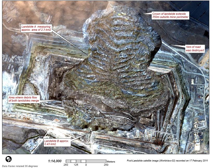
Wow! There are several key things to note here:
- There are two landslides: intriguingly there are collapses on opposing walls of the quarry.
- The size: note the scale bar at the foot of the image – the main landslide is c.300 m wide at the wall of the quarry and almost a kilometre in length. The text accompanying the image above indicates that the area covered by the two landslides is about 2.73 square kilometres.
- The images suggest that Landslide B occurred first as the toe appears to have been covered by debris from Landslide A. Understanding the sequence here is really important. I wonder if landslide B triggered landslide A in some way, whether they were both triggered by the same phenomenon, or that they were independent events.
- The accompanying text in the UNOSAT document suggests that Landslide A was rotational. I suspect that this is not strictly the case – to me it looks more like a translational failure with a considerable amount of flow. However, the transverse ridges (basically the bands that run across the landslide subparallel to the quarry wall) suggest that the slide was retrogressive (i.e. that it failed in stages consisting of sections of the backscarp slipping one after the other). Each of these successive quarry wall failures may well have involved rotation.
The best publicly available aerial image of the slide that I have been able to find is this one, from here:
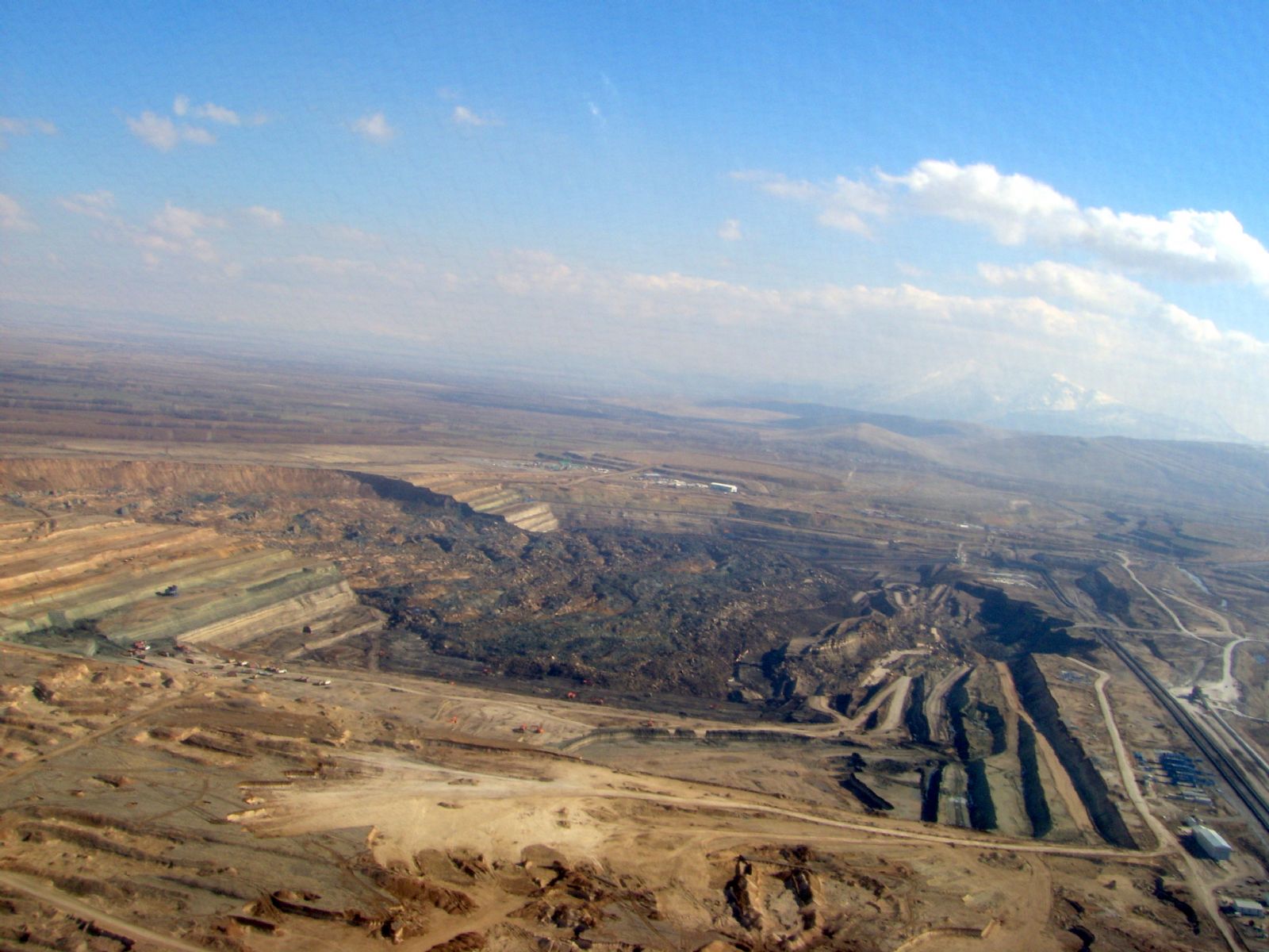
Landslide A is on the left side of the image. The retrogressive nature of the failures is clear, as is the the flow style of movement. Landslide B is on the right – there may be an element of rotation here, but it is hard to tell. The challenge of clearing up the debris is manifest.
 Dave Petley is the Vice-Chancellor of the University of Hull in the United Kingdom. His blog provides commentary and analysis of landslide events occurring worldwide, including the landslides themselves, latest research, and conferences and meetings.
I’d say landslide B’s ground vibrations set off landslide A. A’s subsequent upstream wall failures were influenced by the direction-angle of its structural layerings, and their respective ‘strengths’ in the layer formations.
BTW ! Thanks for this great update and photos !!! I’d been wondering further about this event, and it’s very nice to see large scale photos that illuminate it well !
http://etd.lib.metu.edu.tr/upload/12609939/index.pdf.
On page 78 he nails the smoking gun !
[Dave – maybe, though the fault shown in the cross section is hypothetical. However, such faults do clearly occur in this area.]
The astonishing Çöllolar Coalfield landslide in Turkey – AGU ……
Here at World Spinner we are debating the same thing……
I think there are several stages involved in the failure of the pit slope.
In the main body of the slide (A), the inital mechanism appears to be purely translational, up to the pit slope boundary. Once the intial translational displacements had taken place, this allowed a more roational failure mechanism to develop and extend beyond the mine perimeter.
The intial translational displacements are low-angle with the failure being controlled by a weak, low angle geological layer or fault daylighting in the footwall. There could also be some influence of high angle faulting in the rock mass towards the pit perimeter too.
It would be interesting to view any slope monitoring data they had!
[…] And this (courtesy of Caner Zanbak), is the Collolar lignite mine landslide in Turkey two years ago: […]
[…] Courtesy of Caner Zanbak, is the Collolar lignite mine landslide in Turkey: […]
[…] arada, bir anekdot aktarayım, şifahen Dinçer Abi’den (Dinçer Çağlan) bu felaketin tek seferde gerçekleşmediğini ve klasik kaşık tipi bir kayma olmadığını öğrendim. Ona […]
[…] this is just the latest in a long line of mine related accidents in Turkey (this example remains one of the most remarkable landslides of the last decade), and of course I have highlighted […]
in this land, there are high plasticity organic, black clay layers which is parallel to coal layers. There are almost vertical discontinuities in coal.
This landslide has more than one stage, first lanslide occur on the two surfaces in the coal layers. one of them black clay another one vertical discontinuities (Sarma method).
After this movement second stage landslide was occured. Upper layers included too more water. Therefore upper layers moved with water as a circular failure.