
7 June 2010
Latest image of the spillway at Attabad
Posted by Dave Petley
The wonderful people at Focus have provided an image of the state of the spillway at Attabad that is very instructive. This was taken today:
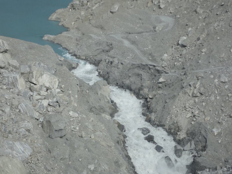
The current state of play is I think as follows. Flow appears to be constrained by two blockages but, as a commenter has noted, one is a rock spur out of the channel. The blockage appears to have formed a small waterfall / rapid. Downstream of the blockage the channel has widened dramatically – and indeed a section of the track has now been lost.
To me this suggests that the crisis may be far from being over. In particular, the loss of this barrier could cause a rapid increase in flow rate that could be highly erosive. It is however important to stress that interpreting the state of play from photos is difficult.
 Dave Petley is the Vice-Chancellor of the University of Hull in the United Kingdom. His blog provides commentary and analysis of landslide events occurring worldwide, including the landslides themselves, latest research, and conferences and meetings.
The retrogressive erosion seems to have come back to where the latest photo gives the illusion that the stream is pinched shut; however it is a high spur that will likely fall into the stream in not too long a time.Above that illusory pinch point there is a pool up to the upper boulder with two distinct eddy domes.You wouldn't want to be swimming there, but the speed of the water there is much lower, i.e. less erosive, than on the steeper slope immediately downstream. There must be a substantial boulder at the bottom of this pool. Things could begin to happen quickly if/when the retrogressive erosion undermines this boulder, but then we will have to wait to see what happens with the upper boulder.Because of low water speed, erosive forces around the the upper boulder are relatively low.Possibilities range from sudden failure to steady state to even a collapse of material that blocks the flow and increases the water level.George
There seem to be lots of huge boulders in the natural dam.My guess is the dam will hold up well after all the fine soil has been washexd away.
Further examination of the upper boulder and waterfall leave me with the impression that the waterfall is running over an adjacent boulder that is directing most of the flow to the right while a small portion goes over the boulder. These two boulders at the top are controlling the flow volume for now.Perhaps the bank widening exposed the underwater boulder. I wonder if the exposed boulder is the one that a man was photographed straddling the spillway trench.George
It looks like the white water zone is getting pretty wild, and much closer to the lake than it was. I note the boat service has been rescheduled… going anywhere near this area would take more guts than I possess!
It seems very likely, almost certain, that headward gully erosion is propagating upstream toward the lake outlet. If(when)the outlet channel (spillway) deepens due to channel scour, discharge out of the lake will rise quickly and dramatically.Here in Northern California we have landslide/dam events similar to this quite often, and the resulting temporary lakes frequently drain catastrophically.
Is it possible that the blocks in the top of the spilway are only blocking erosion to the side, but not to the ground?I assist the first comment saying, that at the rocks the water seems to be flowing slower than in the lower areas. Additional at the boulders the channel is less wide as well. Less wide and slower flow means: Obviously we see more water flowing in the lower than in the upper part – and to me this can only mean, that we do not see most of the flow in the upper part, because the spillway is deeper there than is looks like.Any comment on this?Btw. I am NO specialist in geographics, geologics or something like that – only an mechanical engineer.
Amazing to think its only taken a few days of flow to remove the excavated spoil that took the FWO months to achieve …. I can't see anything too rapid happening – there seems to be a plentiful supply of very large boulders ready to fall into place and slow the erosion ….Gavin
Because of the position and angle this photo was shot at, it does make it appear that the spillway channel is significantly different compared to earlier photos, seemingly much shorter. But I think this is just an illusion.If you look at the photo at the link below, which was taken no more than a few hours before the one in this post, but from roughly the same position as photos taken in prior days, you can tell that the changes are relatively minor: sideward erosion causing collapse of the flanking banks, but little change in the spillway channel path and depth.Apparently no change in the lake level yesterday, although flow is up to the high 4000s, so it seems to be matching the gradually increasing inflow due to the rising temps. http://pamirtimes.files.wordpress.com/2010/06/spillwaynew1.jpg
Large boulder hits WA SR 20:http://www.flickr.com/photos/wsdot/sets/72157624225747814/While this is not a major landslide, I don't see too many examples of large rocks like this that land right in the middle of the roadway.
Now there are some rumors of controlled blasting of these boulders. However, these have already been denied by NDMA.
Based on updated progress of water flow, it manifests that blockage fabric is mostly consist of boulders and granular material, which will maintain the rate of side errosion at a certain level,in turn it will slow the process of water level reduction at upstream. The current water discharge force us to assume that more or less some 70 % of current reservoir vloume may become permanent.What,s your opinion Dr. David?Engr. Farman karimDubai