
9 June 2010
Slowing evolution of the spillway at Attabad
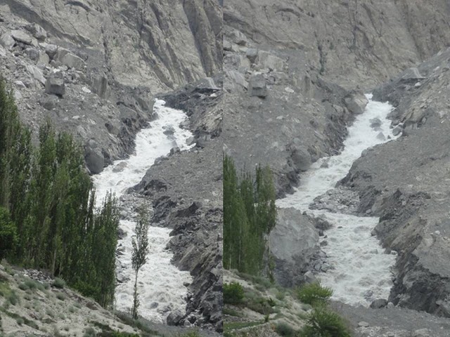
Posted by Dave Petley
Once again I am grateful for Focus Humanitarian Assistance for sending the latest photos of the spillway at Attabad. The rate of change new seems to be slowing as flow is being controlled by the large boulders at the head of the channel. This pair show the downslope side of the channel – the left hand image was taken on 7th June and the right hand image a day later:

Allowing for the slight change in camera angle, there is little indication of major change between the two images. The large boulder on the left side of the upper part of the channel bank has slipped into the water on the right hand image, presumably indicating that channel widening is continuing. Of course there may well be some continued erosion of the bed that would is not visible here.
In the upper channel there is comparably little evidence of change also. The inset image is from 7th June, the main image a day later:
It may be that a more detailed inspection on the ground would reveal a more dynamic system.
It is my intention to stop duplicating posts on the two sites from today, with the Hunza Monitoring Blog being used once again to present data on the state of the dam and the lake, and Dave’s Landslide Blog to provide a commentary. On DLB I will also start covering other landslide events again.
 Dave Petley is the Vice-Chancellor of the University of Hull in the United Kingdom. His blog provides commentary and analysis of landslide events occurring worldwide, including the landslides themselves, latest research, and conferences and meetings.
To us geomorphologists a half-world away, a channel longitudinal profile would greatly help us understand what is happening. Ideally, a small-scale profile shows the thalweg of the stream reach that includes the landslide deposit, the lake, and a bit of channel both upstream and downstream. Plus, a large-scale diagram shows us the longitudinal profile of the thalweg of the lake outlet, the landslide deposit that is being worked by the stream, and a short reach of downstream channel.From what little information is attainable from viewing the photos, it still seems to me that a catastrophic breach of the dam spillway is a realistic possibility.
Plus, stereoscopic sets of images would be excellent.When I look at the two side-by-side photos taken one day apart, cross my eyes and in my mind overlap the two photos by tweaking my eyeball parallax and distance focus just so, it gives me a pseudo-stereo view that quickly turns into a brain cramp. (You stereoscopic veterans know just what I'm talking about.)
I am surprised for the quality of the dam, in the sense that it is quite resistant to erosion.I think that this could be because of, during the landslide, the big boulders arrange themselves at the bottom, and the fine soil covers them. That gives the impression of a weak dam, while it is in fact built with big and interlocking boulders.Is this possible?
Hi Dave,I would like to get your comments on the locations of Braldu river in Pakistan that comes off Baltoro and other glaciers . These two locations are;A) +35° 43' 53.48", +75° 39' 56.95"B) +35° 43' 12.57", +75° 41' 18.54"The river becomes very narrow and and at location A, it's going deep into the rocks. This is also mentioned in the book by Isobel Shaw, Pakistan Trekking Guide: Himalaya, Karakoram and Hindu Kush.Thanks,Kashif, Canada
What is the slope from the inlet to, for instance, the end of the now-mostly-vanished bulldozed slope? What has my attention are the apparently shrinking mounds on the right side opposite the blocking boulders. I wonder how much is being carried away not by the stream per se, but by hidden flows under the right side. If they are present, and they do propagate upstream, then it seems that the outflow could increase quite quickly.That said, I have been continually surprised at how uneventful this overtopping has been. How long before we decide that the spillway's engineers did a great job?Worth mentioning: Dave's red-lined photo predictions have been largely fulfilled.
"How long before we decide that the spillway's engineers did a great job?"If you are talking about humans, then never is probably too soon. If you are talking some natural engineering of constructing the dam with large boulders, then maybe.I'd like to see some scientific evidence that suggests that human action kept this dam up this long. It'd be my guess that if the dam were not excavated, these events would be basically the same. But the residents of the area would not have been happy.
The underwater boulder at the top river right of the bottleneck appears to have turned clockwise and the right bank imediately below it has given away so that water is now flowing both sides and over the boulder.More erosion right of this boulder looks like where the channel could evolve. The boulder could continue to slide or rotate depending on what it rests upon. At this high point in the channel there is little more than static pressure against this boulder as the water above has only dropped a small amount.The smooth water over the top of the boulder indicates an acute triangle with its apex near the right bank. Limestone (if that is what it is) in water can get quite slippery.George
Video by Hunzaonline taken 11 hours ago:http://www.youtube.com/watch?v=tfsQqk8QiII&playnext;_from=TL&videos;=WvCok2-i9G0&feature;=subDoes anyone know1- What is the composition of the mountains and landslide? Clay? Sedimentary? Granite? Metamorphic?2- Is the boat shuttle still in service since the water started flowing downstream again?
I found this video of a earth dam being eroded by a river. Is this what one expects will happen to the Attabad dam.http://www.opb.org/programs/ofg/segments/view/1651
The video linked by Kamo two comments above is excellent. It really gives one a good sense of what is controling the flow at the top of the channel. You also get a better sense of the channel elevation at different points than is apparent from telescopic images from far away.In my naive reckoning, it seems like the "big rock" noted in other images in threads below doesn't yet seem to be the big factor. Rather, the choke point right now seems to be about 10-15 meters up stream.
Regarding that OPB video, it should be noted that 100% of the sediment was placed at the dam because of changes in the flow rate, and thus the entrainment velocity was not maintained.Dams have a problem with sedimentary formation. It's quite expensive to maintain a dam, and that was the reason that the Oregon dam was demolished.I'm actually going to be in that area later this month. Maybe I'll check it out closer.