
October 18, 2019
Nordenskjold Glacier, South Georgia Retreat Accelerates
Posted by Mauri Pelto
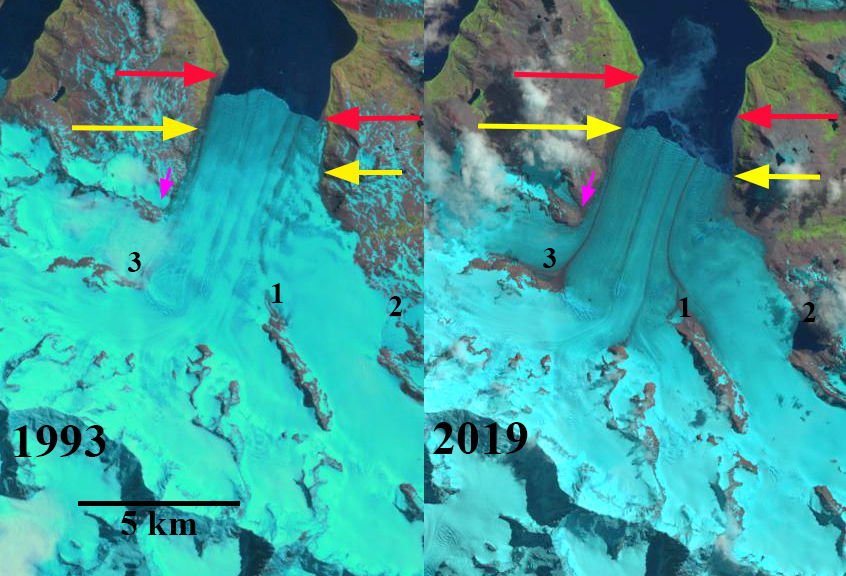
Nordenskjold Glacier in 1993 and 2019 Landsat images. Red arrow is the 1989 terminus location, yellow arrows the 2019 terminus location. Purple arrow is a tributary that has separated. Point #1 and #3 is expanding bedrock ribs. Point #2 is an impounded glacial lake.
Nordenskjold Glacier is a tidewater glacier flowing into Cumberland East Bay on the east coast of South Georgia, Island. Cook et al (2010) and Gordon et al (2008) noted a pattern island wide with many calving glaciers having the fastest retreat. Gordon et al., (2008) observed that larger tidewater glaciers remained in relatively advanced positions from the 1950’s until the 1980’s, followed by significant recession, this retreat was delayed on Nordenskjold Glacier until 2000. The map below from the British Antarctic Survey indicates the slow retreat from 1957-1998 and a more rapid retreat since. Here we use Landsat imagery from 1989-2019 to identify changes.
In 1989 the glacier terminated at approximately the same location as in 1957. Vegetation extended quite close to the terminus with a minimal trimline or recently deglacated zone evident. At Point #1 and #3 are bedrock ridges that generate medial moraines. At Point #2 is a glacial lake impounded by a secondary terminus. At the purple arrow is a tributary glacier joining the main glacier. By 1993 there has been a limited retreat exposing some newly deglaciated unvegetated terrain adjacent to the shoreline and glacier terminus. There was limited additional retreat up to 2000. This is unusual as the neighboring glaciers had all retreated substantially by 2000. By 2016 the glacier had retreated substantially, ~900 m. The tributary at the purple arrow no longer reaches the main glacier. At Point #2 the impounded lake has expanded slightly and is open water. The snowline is also at 500 m above Point #1 and #3. In 2019 the snowline is again above 500 m. The area of bedrock at Point #1 and #3 has expanded significantly indicating glacier thinning, and greater ablation at this elevation. The terminus has retreated an average of 1250 m from 1989-2019. There is a significant trimline and recently deglacited terrain on the western shore of the bay.
The retreat is much less than on Neumayer, Twitcher or Hindle Glacier. The upglacier thinning suggests this process will continue, with a 3.2 km wide calving front in water of unknown depth calving will continue to be a key driver of retreat.
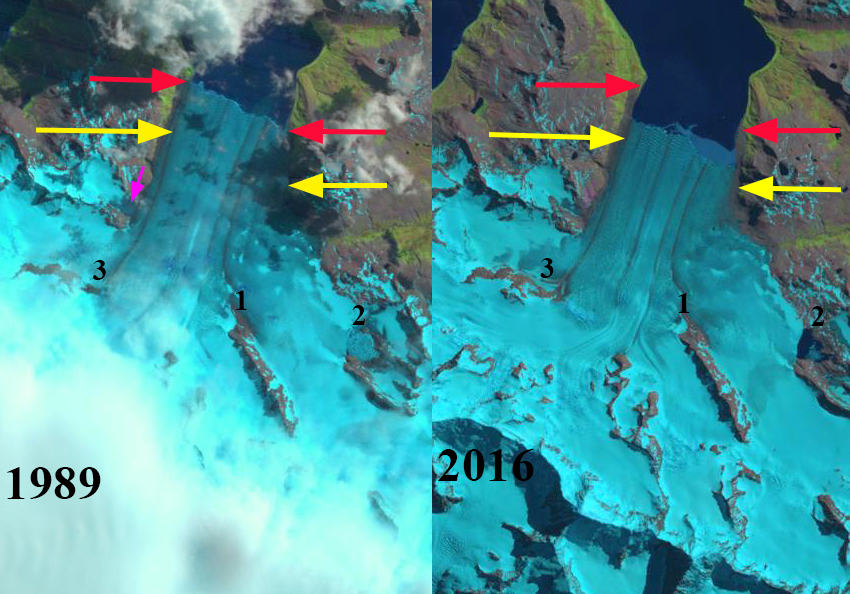
Nordenskjold Glacier in 1989 and 2016 Landsat images. Red arrow is the 1989 terminus location, yellow arrows the 2019 terminus location. Purple arrow is a tributary that has separated. Point #1 and #3 is expanding bedrock ribs. Point #2 is an impounded glacial lake.

Map of terminus change from the British Antarctic Survey map platform
 Dean of Academic Affairs at Nichols College and Professor of Environmental Science at Nichols College in Massachusetts since 1989. Glaciologist directing the North Cascade Glacier Climate Project since 1984. This project monitors the mass balance and behavior of more glaciers than any other in North America.