February 8, 2019
Cachalote Glacier, Chile Retreats From Lake and Separates
Posted by Mauri Pelto
Cachalote Glacier in a 1984 Landsat image and 2019 Sentinel Image. Red arrow is 1984 terminus location, yellow arrow the 2019 terminus location and the pink arrow a tributary to the glacier in 1984 that separates.
Cachalote Glacier is on the western edge of the Southern Patagonia Icefield, Chile. The glacier is not fed by the main icefield, but is connected to glaciers that are. The glaciers of the SPI have been experiencing significant mass loss and overall retreat. Willis et al (2012) observed significant mass loss from 2000-2012 of −20.0 Gt per year. Davies and Glasser (2012) indicate this area had its most rapid retreat of the 1870-2011 period after 1986.
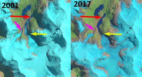
In 1984 Cachalote Glacier terminated in a proglacial that was ~600 m long, red arrow. The glacier was joined by a tributary from the west ~1 km from the terminus, pink arrow. By 2001 the tributary had separated from the main glacier. The glacier still terminated in the proglacial lake, but had retreated 1.5 km and the proglacial lake was now just over 2 km long. In 2017 the glacier no longer reached the proglacial lake. In 2019 the glacier has retreated 2.6 km from its 1984 position, 30% of its entire length lost in the span of 35 years. The glacier no longer terminates in a lake and ends near the top of a steep slope, both suggest that retreat should decline for the near future.
This is a less spectacular retreat than at HPS-12 Glacier which is a short distance to the norther and is the fastest retreating glacier in the region or Dickson Glacier on the east side of the icefield, but as a percent of glacier length lost is as substantial.
Cachalote Glacier in a 2001 and 2017 Landsat images. Red arrow is 1984 terminus location, yellow arrow the 2019 terminus location and the pink arrow a tributary to the glacier in 1984 that separates by 2001.
Cachalote Glacier with flow lines indicated.


 Dean of Academic Affairs at Nichols College and Professor of Environmental Science at Nichols College in Massachusetts since 1989. Glaciologist directing the North Cascade Glacier Climate Project since 1984. This project monitors the mass balance and behavior of more glaciers than any other in North America.