
November 1, 2017
Chaxiqudong Glacier, Tibet Retreat From Lake & Tributary Separation
Posted by Mauri Pelto
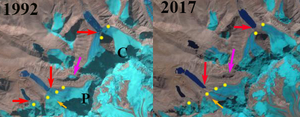
Chaxiqudong Glacier (C) at right and Paqu Glacier (P) at left in Landsat images from 1992 and 2017. The red arrow indicates the terminus in 1992 and the yellow dots the 2017 margin. Purple arrow indicates a glacier that disappeared and orange arrow separation of Paqu Glacier. Both glaciers no longer reach the lake.
Chaxiqudong Glacier and Paqu Glacier are located in a sub-range north of the Nepal-China border. Chaxiqudong Glacier is adjacent to Longmiojian Glacier. The glaciers drain into Nepal entering the Bhote Khosi River. The Bothe Khosi had a hydropower project that has been put out of service by a 2015 earthquake and 2016 flood event. King et al (2017) observe significant surface lowering in the ablation zone of both glaciers (Figure 2), though less than on neighboring larger glaciers. Zhang et al (2010) observed the loss of glacier area and lake expansion in the region from 1976-2006. Here we examine Landsat imagery from 1992 to 2017 to observe changes.
Chaxiqudong Glacier terminus in 1992 is in a proglacial lake at the junction of a pair of tributaries red arrow). Paqu Glacier has a wide terminus in a proglacial lake (red arrow). By 2001 Chaxiqudong Glacier has separated with the eastern tributary still at the margin of the proglacial lake and the western tributary having receded from the lake. Paqu Glacier still is in contact with the lake on a narrow front on the west margin of the lake. By 2015 both tributaries of the Chaxiqudong Glacier have receded significantly from the lake. Paqu Glacier has retreated from the lake and has separated into two sections, orange arrow. By 2017 Chaxiqudong Glacier has retreated 400 m since 1992, no longer terminates in a lake and has separated into two glaciers (yellow arrow). Paqu Glacier has retreated 5oo m no longer terminates in a lake and has separated into two glaciers (yellow arrow). The retreat of each glacier has occurred without significant calving indicating a retreat driven by negative surface mass balance. The retreat is less than on the larger Yanong and North Yanong Glacier to the east that also end in lakes still. The retreat of these glaciers from the lakes also reduces the threat of glacier lake outburst floods, as both the risk of calving and avalanches caused rapid water level change have declined. At the purple arrow is a small cirque glacier in 1992. This glacier still exists in 2001, but has disappeared by 2015.
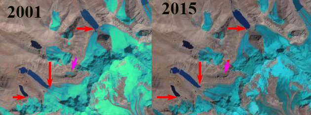
Chaxiqudong Glacier at right and Paqu Glacier at left in Landsat images from 2001 and 2015. The red arrow indicates the terminus in 1992. Purple arrow indicates a glacier that disappeared. Both glaciers no longer reach the lake.
 Dean of Academic Affairs at Nichols College and Professor of Environmental Science at Nichols College in Massachusetts since 1989. Glaciologist directing the North Cascade Glacier Climate Project since 1984. This project monitors the mass balance and behavior of more glaciers than any other in North America.