
March 8, 2013
Sheldon Glacier retreat, Adelaide Island, Antarctica
Posted by Mauri Pelto
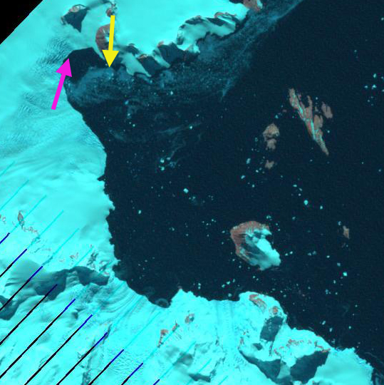
Sheldon Glacier drains east from Adelaide Island and is close to the British Antarctic Survey (BAS) Rothera Research Station. This research camp has a webcam if you want to see current conditions. Adelaide Island is off the west side of the Antarcitc Peninsula, the first image is from the USGS-BAS joint mapping project Ferigno et al (2008). In this region the BAS completed a study ((Cook et al, 2005) that indicated that 87% of the 244 marine terminating glaciers in the area were retreating over the last 60 years. This ongoing BAS study generated maps such as the one of Sheldon Glacier indicating the retreat of the north portion of the terminus of 2.5 km and 1 km of the southern section from 1947-2007.
  . An examination of the terminus of the glacier from a 1991 Landsat, 1999 Google Earth, 2011 and 2013 Landsat image indicate the retreat. The yellow arrow points to the same location off a prominent peninsula, where the glacier terminated in 1991. The pink arrow indicates the terminus position in 2013 in each image. The pink arrow is at the base of an icefall, the extensive crevassing creating the darker blue and varied colors. The retreat from 1991 to 2013 in this embayment at the northern edge of the glacier front has been 2 kilometers. If this retreat has been due to either basal melt enhanced rifting and accelerated calving as noted at Fleming Glacier or Jones Ice Shelf, this process will have ended in the embayment, as the icefall would indicate a rise in the bed elevation beneath the glacier.


 Dean of Academic Affairs at Nichols College and Professor of Environmental Science at Nichols College in Massachusetts since 1989. Glaciologist directing the North Cascade Glacier Climate Project since 1984. This project monitors the mass balance and behavior of more glaciers than any other in North America.