April 30, 2012
Albrectbreen, Svalbard retreat and thinning
Posted by Mauri Pelto
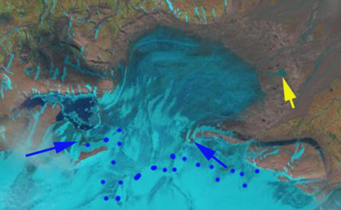
Albrechtbreen is a glacier draining the northeast side of the Edgoya Ice Cap.  James et al (2012) report that the glacier retreated at a rate of 33 m/year from 1971-2000 and 64 m/year after 2000. The glacier terminates on an outwash plain at 50 meters, and begins from the ice cap at 300 meters. From 1971-2005 the ice cap has had a mass balance loss of -0.6 m/year (Nuth et al, 2010). The Albrechtbreen has had a more negative mass balance losing 34 m in thickness, essentially 1 m/year (James et al, 2012). The thinning has not been isolated to the margin of the glacier, with the greatest thinning occurring at 150 meters. The retreat and thinning is identified in the Figure from James et al (2012).
 In this post Landsat imgery from 2002, 2005 and 2010 is utilized to identify marginal changes and upglacier thinning. The blue dots in each image indicate the snowline, the yellow arrow a distinctive lake beyond the terminus that can be used to gage the retreat from 2002 to 2010, and the blue and violet arrows indicate locations where bedrock exposure has expanded as the glacier has thinned. The terminus in the vicinity of the lake has retreated 450 meters in eight years, 55 meters/year.

 . That the thinning extends to the highest areas of the Albrectbreen is not a good sign for its long term survival. The lack of snowcover can be a bit deceiving since much of the accumulation on this glacier is superimposed ice. That is meltwater that is refrozen before escaping the glacier.


 Dean of Academic Affairs at Nichols College and Professor of Environmental Science at Nichols College in Massachusetts since 1989. Glaciologist directing the North Cascade Glacier Climate Project since 1984. This project monitors the mass balance and behavior of more glaciers than any other in North America.