24 November 2014
The Governor of New York Owes an Apology to a Bunch of Meteorologists
Posted by Dan Satterfield
The Governor of New York, Andrew Cuomo, really stepped in it on Saturday. He’s now getting a firestorm of criticism, and he deserves every bit of it, but I want you to understand why before I go into what he said.
There is an old rule among weather forecasters, and it goes like this- “Never forecast a record, you will probably be wrong!”. Now I, and many others, have broken that rule at times, but it serves as a reminder that you had better have a good reason to do so. Why? Because records of rain,snow, wind, and even temperature happen very infrequently, and are very hard to predict.
They are difficult to forecast for several reasons, and chief among them is that you have very little experience in forecasting them by the very fact that they are rare! In addition, the numerical weather models have little experience in handling record events as well, and the normal biases that a forecaster will adjust from model guidance may not be correct in an extreme event. In general, they will certainly not be! Whether it be floods, or heavy snow, record-breaking weather is likely to be under forecasted and in some cases missed entirely. That’s why when a big event happens, and it is forecasted very well, you get the respect of your colleagues. The public may not notice, but other meteorologists do indeed.
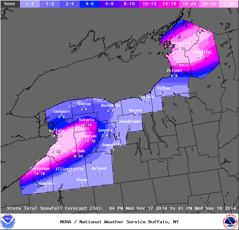
For the past several days, meteorologists in Buffalo (at the NWS, and the local on-air meteorologists) have been the recipient of that kind of respect. They just endured one of the greatest snowfalls on record in this country, and in spite of the fact that it was highly localised in area, making it even harder to predict, they nailed it. It was simply amazing actually, but they NAILED it. No forecast is perfect and hindsight is always 20/20, but you really could not have asked for a better forecast than what the residents of Buffalo got last week.
My friend Don Paul, who’s been forecasting Buffalo weather for many years also nailed it, and worked a week of 16 hour days as it happened. Lake effect snow is a very regional phenomenon, and I can tell you that among meteorologists, Don Paul is one of the go to people. I grilled him on the subject last June at a weather conference, because I knew that few forecasters had his experience in forecasting lake effect snow. His viewers are lucky to have him, and probably do not realize how well thought of he is by hundreds of fellow broadcast meteorologists around the country.
So, now we get to the Governor and the firestorm he has started. You can see his statement here, but in general he said that “no one had any idea that there would be that much snow so fast”. This is dead wrong. It’s not debatable, just wrong. Dennis Mersereau at Gawker pulled the forecasts (and public statements) the NWS issued and proved it. Others have done the same.
Here is the forecast discussion posted on the NWS website last MONDAY. You read it and decide.
AREA FORECAST DISCUSSION
NATIONAL WEATHER SERVICE BUFFALO NY
338 PM EST MON NOV 17 2014
.SYNOPSIS…
TWO STRONG LAKE EFFECT EVENTS WILL TAKE PLACE THIS WEEK AS AN ARCTIC BLAST OF COLD AIR MOVES INTO THE GREAT LAKES REGION. A 15 TO 20 MILE WIDE SWATH OF LAKE EFFECT SNOW WILL AFFECT AREAS NORTHEAST OF
LAKE ERIE AND LAKE ONTARIO LATE TONIGHT THROUGH EARLY WEDNESDAY. A SYSTEM WILL DISRUPT THE BANDS WITH GENERALLY LIGHT SNOW FOR MUCH OF
THE REGION WEDNESDAY. HOWEVER…THIS WILL BE FOLLOWED BY YET ANOTHER STRONG LAKE EFFECT EVENT THURSDAY.
&&
.NEAR TERM /THROUGH TUESDAY/…
…HIGH CONFIDENCE LAKE EFFECT EVENT WITH TIGHT NORTHERN GRADIENT AND NEAR BLIZZARD CONDITIONS LATE TONIGHT THROUGH TUESDAY…
A TROUGH OVER THE ADIRONDACKS WILL CONTINUE TO MOVE NORTHEAST TONIGHT WITH AN AREA OF DEPARTING LIGHT RAIN AND TERRAIN DEPENDENT SNOW. THE FOCUS THEN TURNS TO A MAJOR LAKE EFFECT EVENT LATER
TONIGHT…LASTING INTO LATE TUESDAY NIGHT OR EARLY WEDNESDAY.
FROM A LARGE SCALE PATTERN…THIS HAS ALL THE MAKINGS OF A HISTORIC OR AT LEAST WELL REMEMBERED LAKE EFFECT EVENT…WITH SNOW TOTALS EXCEEDING 3 FEET IN SOME AREAS BY WEDNESDAY. THE 24 HR/36+ INCH
EVENT IN 12/1995 FOR KBUF IS HARD TO BEAT…BUT SOME LOCATIONS MAY REACH THIS VALUE TO THE SOUTH. SIMILAR AMOUNTS ARE EXPECTED EAST OF LAKE ONTARIO.
FOR LAKE ERIE…AS IS TYPICALLY THE CASE…EXPECT A VERY TIGHT NORTHERN GRADIENT WITH SNOW LIKELY REACHING BUFFALO/KBUF…BUT POSSIBLY BARELY GRAZING THE NORTHTOWNS. THIS IS NEARLY IMPOSSIBLE TO NAIL DOWN…AND WILL HAVE TO DEAL WITH THE NORTHTOWNS AS THE EVENT UNFOLDS. MEANWHILE…AREAS EAST OF BUFFALO…THE MAIN INTERCHANGES OF THE THRUWAY TO THE SOUTH…AND THE SOUTHTOWNS SHOULD
TAKE A HARD HIT. CONFIDENCE IS HIGH FOR FEET OF SNOW…WITH MAJOR DISRUPTIONS TO TRAFFIC AS SNOW RATES FAR EXCEED THE ABILITY TO KEEP ROADS CLEAR. WILL NOT BE SURPRISED TO SEE SEVERAL HOURS OF
LOCALIZED 3-5 INCH/HR SNOW RATES LATE TONIGHT THROUGH TUESDAY WITH THUNDERSNOW. AT LEAST THROUGH TUESDAY…THE SOUTHERN BOUNDARY
SHOULD BE THE LAKE ERIE SHORELINE ALONG CHAUTAUQUA TO THE BOSTON HILLS…BUT AREAS TO THE SOUTH OF THIS WILL GET INTO THE SNOW BAND LATER TUESDAY NIGHT.
This actually happens rather frequently after a big weather event, and forecasters are used to getting criticism, even when the forecast turned out very well. The main reason is almost always that the person complaining did not listen, or understand what was being forecasted. Yes, it is our responsibility to make the forecast understandable, even to someone with a 5th grade education, and perhaps even to a politician, but at some point you have to use some critical thinking skills.
My friend Meteorologist Don Paul posted the following on his Facebook page late Sunday:
Governor Cuomo’s attempt to scapegoat the National Weather Service for an inaccurate forecast in advance is not only completely in error–the NWS did an outstanding job–but is a disservice to the public and to the hard-working staff of this federal agency. No forecast of such an historical disaster is going to be absolutely perfect, but no one who lives here can say this event was not well forecast in advance, or that the warning headlines of its impact to come were not well explained in advance…his statement is disinformation, purposeful or ill-informed. I want to make it clear that from MY standpoint, what I posted is not a general attack on Cuomo or his performance. It is a criticism of his unfair and inaccurate remarks, nothing more.
The most common error people make is to listen to a forecast for somewhere else and think it is for their area, but others will blame you for a forecast they saw on a social media site by someone who has no background in atmospheric science at all. My favorite story is a complaint I had from a viewer about my forecast for a NW wind at 8-17 mph. The viewer wrote “why can’t you just say 10-20 mph like everyone else?”. I emailed him back the weather observations for the day in question, and the winds were from 8-18 mph. I was off by one mile per hour.
Never heard back from him.
The Governor of New York has joined an NFL coach, and the Governor of Georgia, in criticising weather forecasters for missing a forecast they did not miss. We forecasters make an occasional lousy forecast, and we are used to hearing someone say that we have a job where you can be wrong 60% of the time and stay employed. In science, however, data and observation rule over opinion, and the data says we hit it right about 90% of the time. (See this guest post by Brad Panovich for even more on what the data really shows.)
In this case the forecast was so good, it will become legendary. The NWS forecasters, and on air mets like Don Paul, worked very closely together to give a forecast of nearly unparalleled accuracy for an historic weather event.
The Governor owes the TV and NOAA forecasters in Buffalo an apology.


 Dan Satterfield has worked as an on air meteorologist for 32 years in Oklahoma, Florida and Alabama. Forecasting weather is Dan's job, but all of Earth Science is his passion. This journal is where Dan writes about things he has too little time for on air. Dan blogs about peer-reviewed Earth science for Junior High level audiences and up.