
31 August 2014
How Hot Is Your City?
Posted by Dan Satterfield
From Climate Central.Click image for full report, and see interactive below.
From Climate Central
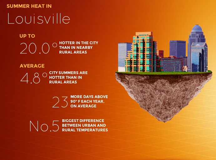
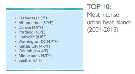
You’ve probably heard about the urban heat island effect, but I bet you do not realize is how much it affects your weather (and how much it costs you in cooling costs). The folks at Climate Central put out a report this month that breaks down how large the temperature differences are between some cities, and the rural areas surrounding them. The report makes it obvious that we are paying a lot of extra money to cool our homes and businesses, while adding more pollution to the atmosphere in doing so. If you live in Louisville, Kentucky then you have about 23 more days above 90 degrees every year due to the heat re-radiated by the roads and buildings.
Check out the interactive below to see how much warmer cities in your area are:
NOTE: There is an error in the interactive, and the FEWER DAYS ABOVE 90 should read MORE DAYS ABOVE 90.
Embed Code:
The extra heat speeds up chemical reactions and causes increased ozone to form as well. In other words,the same vehicle pollution levels in a rural area, will lead to less ozone than in cities because the temperature is cooler there.
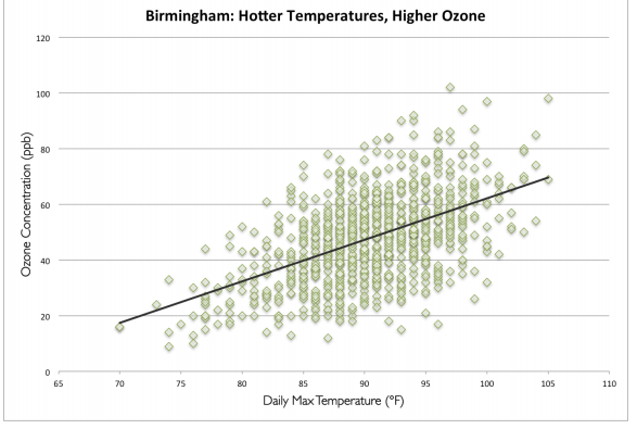
Hotter temperatures cause a dramatic increase in ozone levels. From Climate Central report.
If you are in Washington, D.C., you can easily feel the heat island for yourself. I recently rode the metro from downtown, out to New Carrolton station in Maryland, and the temperature drop was at least 6 degrees. The DC heat island is one of the biggest in the U.S., and forecasters like me must take it into account every day. I even factor it into account when making snowfall forecasts and overnight low forecasts in smaller cities.
How do we fix it? Making our cities more green and reflective is one way, but a paper in NATURE last month (July 2014) indicates that the heat island in cities has to do with the fact that cities are aerodynamically smoother than tree covered areas around them, and this reduces convection of the heat to higher levels.
 Dan Satterfield has worked as an on air meteorologist for 32 years in Oklahoma, Florida and Alabama. Forecasting weather is Dan's job, but all of Earth Science is his passion. This journal is where Dan writes about things he has too little time for on air. Dan blogs about peer-reviewed Earth science for Junior High level audiences and up.
Very interesting & troubling post. The urban-rural differentials needs context. Seattle is near the top in the differential, but so far we have relatively few really hot days. (Summer during el Niño years is something else again.) Seattle is surrounded by cool surface water, ranging from an average of 8°C in winter to 12°C in summer (currently 15°C). The summer air temperature in central Seattle can reach 90°F in July/August but areas like the nearby Kitsap Peninsula, surrounded on three sides by water will usually have an air temperature 10° cooler.
I am somewhat amused by your American use of units: Celsius for water, Fahrenheit for air, and when you are talking of both together, no meaningful units whatsoever.
The interactive from Climate Central put the data in degrees F. Yes, we are the last nation in the world not to use metric, but (on most days at least) I’m convinced that Americans are smart enough to learn SI. I otherwise make blog posts in SI unless there is good reason not to.
I don’t get the idea of cities being aerodynamically smoother than surroundings and that adding to heat by less convection. What is the wind tunnel effect in cities then? Especially in cities like Denver and Las Vegas where surroundings don’t have trees, I expect something else is going on. In the dry dessert places there might actually be more evapo-transpiration in the city with irrigation than in the surroundings.
The bernoulli effect (wind tunnel) is not really applicable here. I suggest you read the paper in Nature. Evapotranspiration is obviously higher in some metro areas ( and their surroundings) than others, and this certainly has an impact on the magnitude of the heat island effect.