26 June 2012
Brutal heat and Severe Flooding
Posted by Dan Satterfield

Brutal heat is likely from Colorado to the East Coast later this week. This is the NAM forecast model for 4 PM CDT on Thursday.
Highs reached 109 (over 40 degrees C for the rest of the more enlightened the world) in Oklahoma on Monday and it was 105 in Limon Colorado and above 105 across much of Kansas. It even reached 102 in NW Alabama but I think the heat will get much worse later this week and spread over an unusually large region fo the U.S. In 33 years of forecasting I have never seen an NWP model forecast 115 degrees Fahrenheit east of the Rockies but I did today. The increasingly severe drought from Georgia to the Plains will get much worse with this high heat.
Down in Florida this morning, the stalled Tropical Storm Debby is producing flooding rains of over 20 inches. The Sopchoppy river is now forecasted to flood in a few hours at 41 feet! Well above any previous measurement.
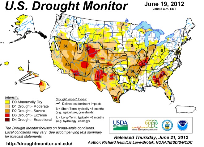
Here is the latest long-term drought index-
PRELIMINARY LOCAL STORM REPORT
NATIONAL WEATHER SERVICE TALLAHASSEE FL
1147 PM EDT MON JUN 25 2012
1146 PM HEAVY RAIN 1 ESE SANBORN 30.07N 84.59W
06/25/2012 M20.10 INCH WAKULLA FL MESONET
20.10 INCHES OF RAIN MEASURED OVER THE LAST 24 HOURS.
It looks like it is going to be a long summer. Also, keep in mind that the raw surface forecasts from the main NWP models tend to underestimate high temperatures. The Model Output Statistics (MOS data) is forecasting hotter than you see in that top graphic and is likely more correct. Arctic sea ice by the way, is dropping like a rock…more on that soon.


 Dan Satterfield has worked as an on air meteorologist for 32 years in Oklahoma, Florida and Alabama. Forecasting weather is Dan's job, but all of Earth Science is his passion. This journal is where Dan writes about things he has too little time for on air. Dan blogs about peer-reviewed Earth science for Junior High level audiences and up.
How frequently has the continental U.S. (or pick a spot) had multiple days of triple digit temperatures? Those temperature data would be found on the weather service site?
Looking forward to high temps in Huntsville! — Not!!!
Thanks!
Do you see any long term patterns in this weather or can you reason ally say that there extreme patterns are something other that normal. (climate change)
Hot in huntsvegas.