
7 December 2016
The Icy Bay landslide in Alaska: a nice video describing the link with glacial melting
Posted by Dave Petley
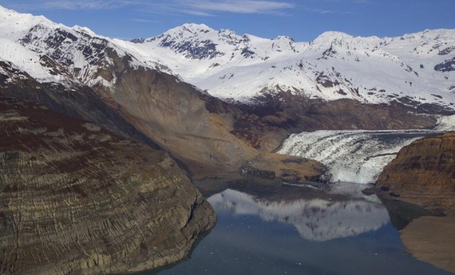
The Icy Bay / Tyndall Glacier landslide via Chris Larsen at the Geophysical Institute of The University of Alaska Fairbanks
.
The Icy Bay landslide in Alaska
A very nice video has been posted on Youtube describing the link between the giant Icy Bay landslide in Alaska in 2015 (this landslide is also variously known as the Taan Fjord landslide and the Tyndall Glacier landslide), which is the largest known recent landslide in North America, and the melting of the adjacent glacier. The video features Dr Michael Loso, physical scientist at Wrangell-St. Elias National Park. The landslide, pictured above, occurred on 17th October 2015 occurred on the flanks of Taan Fjord in Icy Bay in Alaska. I featured this landslide, which was detected via the seismic detection system developed by Goran Ekstrom and Colin Stark, in a blog post at the start of this year. As noted above, this is the largest recorded landslide in North America, with a volume of about 72 million cubic metres and a mass of about 180 million tonnes. The landslide generated a large tsunami that caused extensive damage along the flanks of Taan Fjord.
.
Many thanks to Nathan Soboleff for pointing this one out to me.
A video about the landslides from the Kaikoura earthquake
Meanwhile, work to manage the many landslides from the Kaikoira earthquake continues. GNS Science has posted a nice video in which Dr Chris Massey explains some of the key features of the landslides, and the work they are doing to try to monitor them:
.
Other posts that might be of interest regarding giant landslides in Alaska
- Glacier Bay Landslide in Alaska: a satellite image and new videos
- Lamplugh Glacier rock avalanche: A massive new landslide in Alaska on Tuesday
- The Tyndall Glacier landslide: images from the University of Alaska Fairbanks
- The Tyndall Glacier landslide in Alaska: the largest recorded non-volcanic landslide in North America
- Sitka landslide in Alaska – the potential power of simple geomorphic mapping
- Ferebee Glacier: another rock avalanche in Alaska
- Mount La Perouse: Sunday’s rock avalanche in Alaska has been found
- Breaking news: a very large landslide in Alaska on Sunday
 Dave Petley is the Vice-Chancellor of the University of Hull in the United Kingdom. His blog provides commentary and analysis of landslide events occurring worldwide, including the landslides themselves, latest research, and conferences and meetings.
Further to the Kaikoura earthquake: “Three quake landslide dams at high risk” article can be found at http://m.nzherald.co.nz/nz/news/article.cfm?c_id=1&objectid=11761114 . There you’ll find pictures of the most at-risk dams.