
17 November 2015
High resolution imagery of the Bento Rodrigues dam failures
Posted by Dave Petley
High resolution imagery of the Bento Rodrigues dam failures
Thanks to the many people who have been providing comments on my posts about the Bento Rodrigues dam failures (see posts here, here, here and here). We have been frustrated by the lack of high resolution images, either satellite or aerial photograph, of the failure site. However, overnight Caner Zanbak tracked down a site with SPOT 6/7 imagery of the site, provided by Airbus Defence and Space. For the first time we can see properly what happened. This is an overview of the Bento Rodrigues dam failures:-
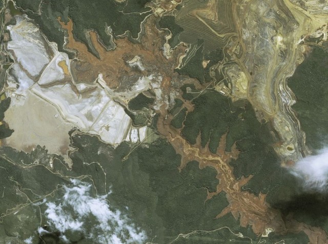
SPOT 6/7 image of the Bento Rodrigues dam failures via Airbus Defence and Space
.
For comparison this is the Google Earth image of the same location, taken in 2013:
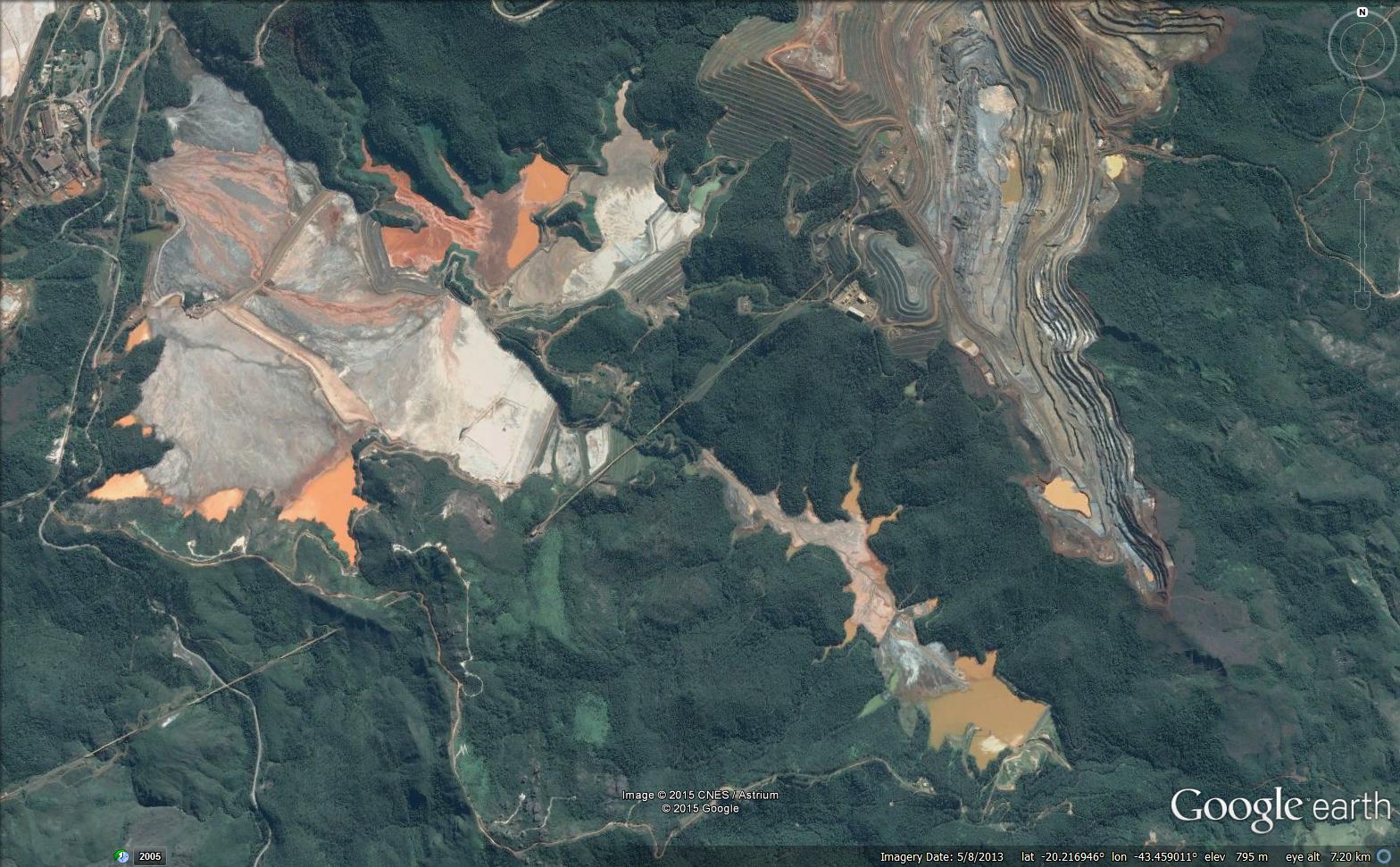
Google Earth image of the Bento Rodrigues dam failures
.
This is a zoomed in image of the failed tailings pond and the Fundao Dam site:
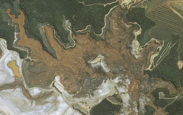
SPOT 6/7 imagery of the Bento Rodrigues dam failures via Airbus Defence and Space
.
This is Google Earth imagery of the same site from 2013. I have annotated the image:
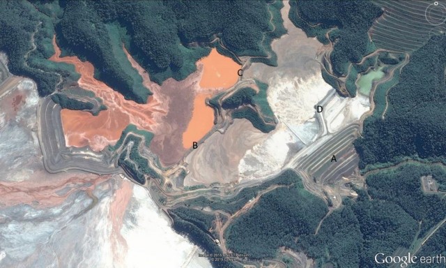
Google Earth imagery of the Bento Rodrigues dam failures from 2013
.
The Fundao Dam, which I have marked A, has filed completely. Indeed there is hardly a trace remaining of the original structure. But note also the near-total removal of the levees marked B, C and D on the image above. This begs the question as to the collapse sequence – did for example, collapse of levee B trigger the failure of Fundao Dam? My sense is that it remains most likely that the Fundao Dam itself failed first, and that the loss of support from the other levees then triggered their subsequent collapse. I cannot see how a collapse of levee B would have triggered collapse of levee C for example, unless this caused a loss of support. However, others will know more about such things than me, and I would welcome comments and observations.
Downstream the debris reached and then overwhelmed the Santarem dam. This SPOT 6/7 image shows the site:

SPOT 6/7 image of the Bento Rodrigues dam failures via Airbus Defence and Space
.
This is the 2013 Google Earth image in comparison, with the dam annotated with letter E:
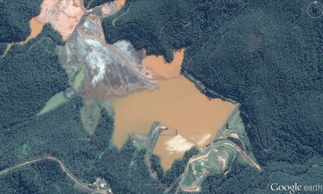
Google Earth image of the site of the Bento Rodrigues dam from 2013 failures
.
Whilst the Santarem dam was undoubtedly overwhelmed and severely damaged, much of the structure appears to be intact – indeed the original spillway is still visible. This structure is now retaining a large volume of tailings, so ensuring that it remains intact must be a priority.
At the moment this event looks like a catastrophic, near-complete failure of the Fundao Dam, followed by failures of the other levees in the tailings ponds. A key question remains as to what caused and triggered this catastrophic failure,
 Dave Petley is the Vice-Chancellor of the University of Hull in the United Kingdom. His blog provides commentary and analysis of landslide events occurring worldwide, including the landslides themselves, latest research, and conferences and meetings.
Interesting to note that whatever the mechanism, it also took out what appears to be a small water reservoir between the Tailings Facility and the Wasterock pile (to the right of D).
Another set of detailed Airbus Industries’ images, June 14, 2015 and Nov 11, 2015…
http://mundogeo.com/blog/2015/11/11/airbus-disponibiliza-imagem/