
7 August 2014
[Bhote Kosi] Sunkoshi (corrected) landslide in Nepal – an update
Posted by Dave Petley
The [Bhote Kosi landslide] Sunkoshi landslide
[The Bhote Kosi landslide now seems to be the accepted name for the landslide that I have been calling Sunkoshi, so I am adopting the local name. So let’s start by looking at what we know about the Bhote Kosi landslide]. [EDIT: The comment below by Ranjan Dahal suggests that the correct term is Sunkoshi, so I am reverting to this terminology] Colin Stark, Goran Ekstrom and Clement Hibert have been looking at the seismic signals generated by the earthquake – it was recorded as an Msw=4.7 (approx.) event. The signal suggests that the landslide occurred at 20:51:44 UTC on 1st August (which is 02:36:44 on 2nd August local time). The landslide force inversion suggests that the landslide mass was about 13.5 million tonnes, which corresponds to a volume of about 5.5 million cubic metres, give or take a bit. This image, kindly provided by Kunda Dixit but taken by Tuk Lal Adhikari and used with permission, shows the [Bhote Kosi landslide] Sunkoshi landslide and the deposit:
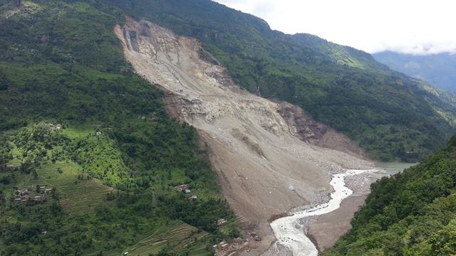
Image courtesy and copyright of Tuk Lal Adhikari
.
Based on this it appears that the [Bhote Khosi landslide] Sunkoshi landslide started as a rockslope failure in the upper reaches – there may be a rotational component, although this is hard to tell, which then triggered a deep failure in the lower section (below the bedrock bench). It is interesting to note the freshly fractured rock in the upper scarp and the flow of water over the face in this region. Note that the landslide spread laterally by some distance to generate a broad, low angled landslide mass.
The lake level at the [Bhote Kosi landslide] Sunkoshi landslide
Clearly in Nepal there is a great deal of concern about the barrier lake that has formed, both because of the potential for a breach flood and because the lake has closed the Araniko Highway to Tibet. The image below, also by Tuk Lal Adhikari, shows the blockage and the channel:
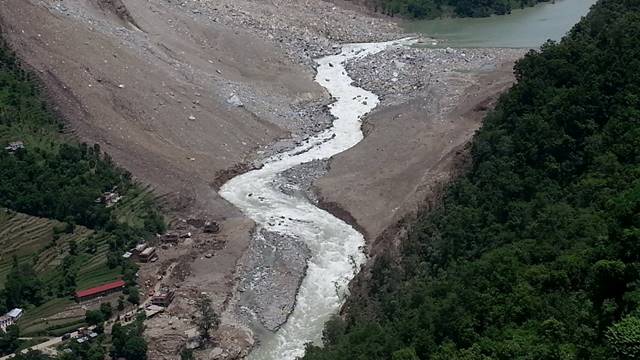
Imagy courtsey and copyright of Tuk Lal Adhikari
.
A few things to note here:
- The channel has a reasonably low gradient, reflecting the broad, low gradient landslide deposit. This means that the chances of a sudden breach event are lower, though cannot be ruled out. A sudden large inflow into the lake would be dangerous;
- The channel does not seem to have incised significantly (reflecting the bedrock nature of the landslide), but has eroded laterally through the weaker surface materials;
- The constraint on the channel is the very narrow section at the dam crest, which has a very rocky surface form.
- If a road is to be constructed over the landslide then it will be either pushed against the foot of the cliff (very hazardous as rockfall activity will continue for a long time), or it will have to cross the river twice, or the river will have to be moved. None of these options are straightforward.
- There is no sign from this image that the lake level has decreased substantially.
So at present the landslide appears to be in a state of status quo. Ripendra Awal of Prairie View A&M University in Texas has taken a look at the gauging station data for Baharabise (4.2 km upstream of the landslide) and Pachuwarghat (38 km downstream) for the period since the landslide. This data is available online here. Ripendra has demonstrated that before the landslide the flows at the two stations were highly correlated – in other words if you know the flow at one you can, using a simple equation, determine the flow at the other (there is a three hour lag between the two stations that needs to be built into this). Ripendra has then generated a graph of the flows at the two stations during the period of the landslide crisis. He sent me the graph yesterday – I have updated it with today’s data and reproduce it below:
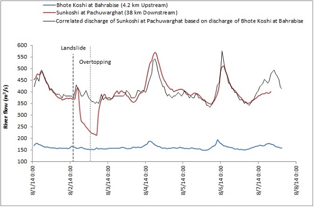
Courtesy of Ripendra Awal, updated by the author
.
The blue line is in effect the inflow of water to the lake, the red is the discharge downstream (much higher because there are other rivers feeding into the Sunkhosi downstream of the dam). The black line is the expected discharge for Sunkoshi as determined from the dam inflow, based on the relationship before the landslide. So, three hours after the dam formed (shown on the graph as the first vertical line) the flow in the Sunkoshi dropped as water was impounded by the blockage. A few hours later the water overtopped, and the flow came back to the expected level.
The difference between the red and black lines thereafter is an indication of the behaviour of the lake trapped behind the [Bhote Kosi landslide] Sunkoshi landslide. If the red line is above the black one then the lake might be draining, if it is below then it might be filling (i.e. the water level is rising). For most of the period since the overtopping the two lines have been very close, suggesting little change in lake level. On 4th and 5th August the red line is a little above the black, so the lake might have been emptying by a small amount, which is consistent with media reports. Yesterday the two were in close lockstep, suggesting little change, which is also consistent with reports. Strangely, today the red is below the black, which might mean that the lake is filling. Don’t read too much into this though – it could also be that the data are not yet reliable or that the Sunkoshi has received a big flow of water from another source.
The key conclusion is that the lake level is not falling appreciably. I would think that this is because the gradient of the landslide body is so low that the channel is not eroding downwards. This was also the case at Attabad. This might suggest that to clear the Bhote Kosi landslide blockage large-scale blasting and/or excavation is going to be needed, but undertaken very carefully of course to avoid a rapid breach. And in turn this suggests that the army have a long and difficult task ahead of them. Meanwhile the road to Tibet remains closed and will be hard to reopen until the lake level is drawn down, and people upstream face difficulties travelling.
The [Bhote Kosi landslide] Sunkoshi landslide represents a very major challenge for Nepal. Unfortunately this is not going to be easy to fix or to manage.
 Dave Petley is the Vice-Chancellor of the University of Hull in the United Kingdom. His blog provides commentary and analysis of landslide events occurring worldwide, including the landslides themselves, latest research, and conferences and meetings.
So this is blocking the only road to Tibet or is it blocking the only road to Nepal for Tibet? Which sounds the same but might have very different consequences for the populace.
Best and Thanks again for all You do to make the world a safer place. motsfo
[Good point. It is currently the only road from India and Nepal into Tibet. There is another road from the south – the Karakoram Highway. That road is of course blocked by the Attabad landslide and lake. To the east, access from the south is through Yunnan…
Thanks for your kind words. D]
I think there was already some intervention (blasting) to artificially create the channel before this picture was taken. The channel seen in the picture might not be a natural channel.
Dear Dave,
Thanks for critical blog, very informative. I have a request, can you name the landslide as Sunkoshi Landslide, the blocked river is Sunkoshi and Bhotekoshi is more than 5 km upstream. We all are naming it Sunkoshi and some of media are following you and asking me/us and Nepal government for clarification. I hope, you also agree that the landslide is on Sunkoshi not Bhote Koshi. Same river above Bahrabise is called Bhotekoshi. Bhotekoshi mixed with Sunkoshi River near to Bahrabise.
Regards,
Ranjan
[Many thanks Ranjan, this is very helpful. I have corrected the post to reflect your comments and will use Sunkoshi from now on. D.]
thanks, Dave! it really help us to name it perfectly, even in scientific literature!