
25 May 2016
Flyover Country—The next generation field-based research tool
Posted by Nanci Bompey
By The EarthCube National Office
This is part of a new series of posts that highlight the importance of Earth and space science data and its contributions to society. Posts in this series showcase data facilities and data scientists; explain how Earth and space science data is collected, managed and used; explore what this data tells us about the planet; and delve into the challenges and issues involved in managing and using data. This series is intended to demystify Earth and space science data, and share how this data shapes our understanding of the world.
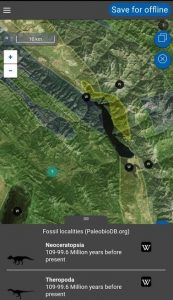
Screenshot of the Flyover Country app
On 18 July 1942, the town of Smethport in northwest Pennsylvania, received 87 cm of rain, sweeping away homes, roads and people, and stripping ground cover down to bedrock. This, the largest daily rainfall in the U.S. not associated with a tropical storm, is a fit metaphor for the deluge of data raining down on the geosciences over the past decades. This unprecedented downpour of data is swamping the existing scientific paradigm of proprietary, closed data and paywall protected, peer reviewed literature, and replacing it with transformative data sharing, open-source programming, visualization apps and distributed networks of domain science data collections complete with analytical tools, e.g., National Geothermal Data System, Marine Geoscience Data System.
Enter Flyover Country
In December 2015, with the support of a National Science Foundation (NSF) EAGER grant, the Flyover Country (FC) team of Amy Myrbo (University of Minnesota Research Associate), Shane Loeffler (2015 B.S. graduate of the University of Minnesota Duluth), Reed McEwan (University of Minnesota M.S. in Geology and Software Engineering) and Sijia Ai (University of Minnesota), launched FC as a geosciences mobile app for air travelers, road warriors and hikers.
Operating the free app is simple. You draw your pathway on an interactive map; the FC app calls Macrostrat.org (geologic maps), NeotomaDB (paleoecology resource, NeotomaDB.org), PaleobiologyDB (PaleobioDB.org), LacCore (lacustrine core, LacCore.org) and Wikipedia—exposing and storing the local geology, paleontology and points of interest along your route. The results are stored in your smartphone or tablet, to be displayed at your convenience, internet connectivity notwithstanding. Your only constraint: The memory available on your smart device. A trial run from Douglas, Arizon, to Fort Collins, Colorado required ~16.4 MB to display a geologic strip map of 400 miles centered on the path,and 83 points of interest, paleontological sites and LacCORE sites.
Since its launch, the FC app has surged like a jökulhlaup, adding 1,000 users each day and topping 100,000 users by May 2016.
Flyover Country for Research
Over the past decade, the nascent technology of digital geologic mapping gathered steam with advances in mobile smart devices—primary and random-access memory, durability, battery life, display, dust and water resistance—that when coupled with the growing availability of digital maps and geologic resources is driving more and more geoscientists down the digital pathway.
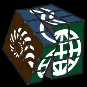
Rubik’s Cube
Credit: Stephanie Mar, Arizona Geological Survey
With funding from NSF’s Geoinformatics division, FC is positioning itself to be the next essential piece of every geoscientist’s field kit from Zanzibar, Tanzania, to the European Union and North America. With the application program interface (API) and graphical user interface (GUI) in place to call, manage and integrate data from multiple data sets, the FC team is grappling with how to organize, deliver and display a variegated suite of domain science data to empower your research, help you visualize data in novel ways, and accelerate the rate of new science developments while keeping pace with the rate of data acquisition and data processing.
The FC team is ruminating on the precise details for intercalating and integrating diverse data, but the details remain fuzzy. Imagine a Rubik’s Cube, with each face representing multiple domain science data and each rotational axes providing for a unique amalgamation of those data. You, the geoscientist, control the cube configuration. You select the elements of the amalgam, blending paleontology, with bedrock geology, geochemistry, stratigraphy, climate records, aqueous geochemistry and more to empower and inform your research.
FC is striving to dramatically broaden its scope by enabling access and data delivery from:
- GPlates: Paleolocation of tectonic plates;
- Open Core Data: Marine and lacustrine sediment cores;
- GeoLink: System for Earth sample registration, includes EarthChem, Data Observation Network and DataONE, among others;
- Minnesota Geological Survey;
- USGIN: U.S. Geological Survey and Association of American State Geologists, the latter should include data from U.S. State Geologic surveys;
- CUAHSI: Consortium for the Advancement of Hydrologic Science.
In order to provide new and extensible tools for the research and citizen science community, GLOBE (a worldwide science and education program funded by NASA and NSF), Digital Crust (4-D Data System on Crustal Material Properties), geoscience publishers, the University of Minnesota Department of Earth Sciences and the Peruvian National Park System, are all considering climbing aboard FC.
As FC expands its database services, a key challenge for geoscientists will be implementing new research strategies for organizing, consuming, evaluating and reporting on the flood of cross-disciplinary data streaming into the geosciences.
Keep your eye on the ground for new developments in Flyover Country.
Flyover Country is a funded project of NSF’s EarthCube initiative. EarthCube is a joint initiative between the National Science Foundation (NSF) Directorate for Geosciences (GEO) and the Division of Advanced Cyberinfrastructure (ACI).
EarthCube envisions a dynamic, community-driven cyberinfrastructure that supports standards for interoperability, infuses advanced technologies to improve and facilitate interdisciplinary research, and helps educate scientists in the emerging practices of digital scholarship, data and software stewardship, and open science. Achieving EarthCube objectives requires a long-term effort which NSF anticipates supporting until at least 2022.
—This post was authored by members of the EarthCube National Office