
October 24, 2017
Gangge’er Glacier, Retreat & Tributary Separation Qilian Mt. China
Posted by Mauri Pelto
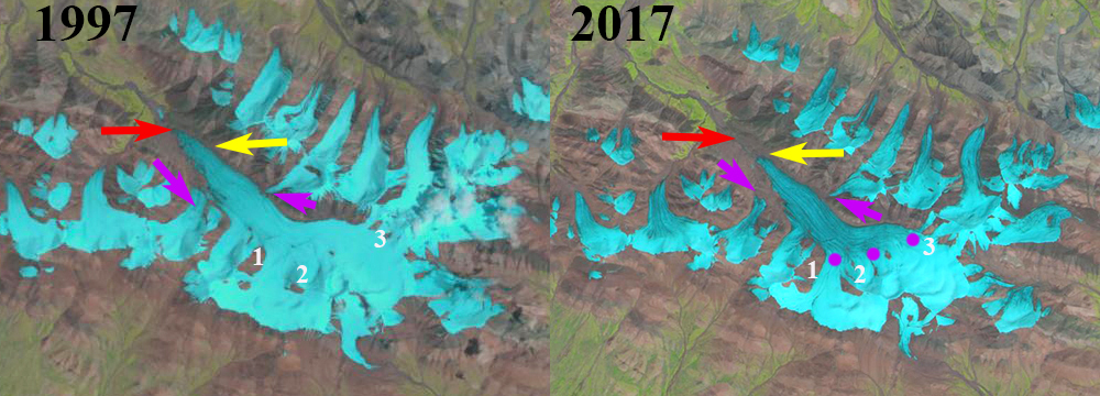
Gangge’er Glacier, Qilian Mt., China comparison in 1997 and 2017 Landsat Images. Yellow arrows indicates 2017 terminus, red arrows the 1990 terminus, and purple arrows tributaries that have detached. The snowline is purple dots and Points 1-3 indicate bare rock areas amidst the glacier.
The largest glacier in the Gangge’er Xiaoheli Shan range of the the Qilian Mountains in China, here referred to as Gangge’er Glacier, drains northwest into the Shule River. Glaciers in the Qilian Mountains in northwest China’s Gansu Province have shrunk by 36 square kilometers, a 4.2 percent loss, during the past decade Quiang (2016). Tian et al (2014) report Qilian Mountain glacier area shrank by 30% from 1956 to 2010 and the shrinkage accelerated remarkably in the past two decades. Yang et al (2015) Results show that mountain glaciers in China are very vulnerable to climate change with 41% of glaciers having had a high vulnerability in the period 1961–2007. For the Upper Shule Basin the impact of glaciers on the overall water resource is not known as Li and Yang (2017) observe that that the basic features of precipitation in the upper reaches of the Shule River were unexplored prior to their study and there is no national weather station in the basin. They found that most of the precipitation occurred during the summer.
What is apparent in a comparison of Landsat images from 1997-2017 is the changes in the glacier. In 1997 the glacier is joined by three main tributaries from the south and four from the north. The western most from the north and south are noted by the purple arrow. The glacier terminates at the red arrow and the snowline is low on the glacier at 4600 m, likely after a summer snowstorm. The areas of bedrock amidst the glacier at Points 1-3 are limited. In 1999 the snowline is above the main stem of the glacier at 4800 m. There has been limited change since 1997, there is a small cloud causing a ground shadow right at the terminus. By 2016 and 2017 the westernmost tributary from the north and south have detached from the glacier , purple arrows. The areas of bedrock amidst the glacier at Point 1-3 have all expanded indicating upglacier thinning. The terminus has retreated to the yellow arrow a distance of 900 m in 20 years. In the digital globe image below extensive surface streams indicate significant meltwater drainage up to 4900 m, above the snowline in both images. The surface streams indicate a cold layer of ice preventing surface meltwater infiltration.
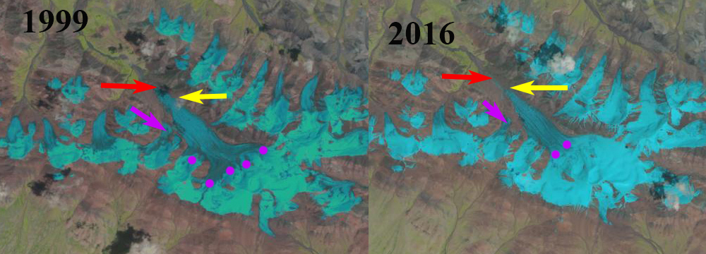
Gangge’er Glacier, Qilian Mt., China comparison in 1999 and 2016 Landsat Images. Yellow arrows indicates 2017 terminus, red arrows the 1990 terminus, and purple arrow tributary that has detached. Points 1-3 indicate bare rock areas amidst the glacier.
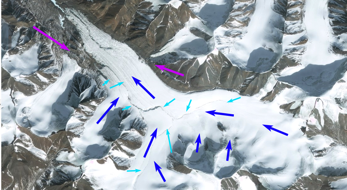
Google Earth image of the glacier indicating flow directions dark blue arrows, surface streams light blue arrows and separated tributaries purple arrows.
 Dean of Academic Affairs at Nichols College and Professor of Environmental Science at Nichols College in Massachusetts since 1989. Glaciologist directing the North Cascade Glacier Climate Project since 1984. This project monitors the mass balance and behavior of more glaciers than any other in North America.