
September 19, 2017
Aneto Glacier, Pyrenees Area Loss & 2017 Snowcover Loss
Posted by Mauri Pelto

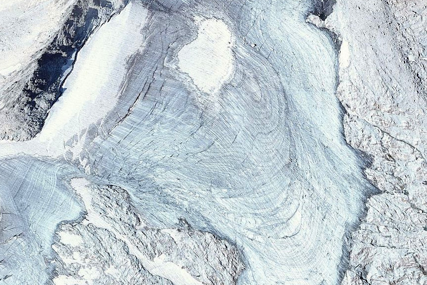
Landsat and Sentinel 2 image from 8/24/2017 indicating the lack of retained snowcover on Aneto Glacier. The bare glacier ice ablates faster than snow.
Aneto Glacier in the Pyrenees of Spain is listed as its largest glacier in a 1984 inventory. In 1984 the glacier had an area of 1.32 square kilometers and a length of 1.6 km (Serrat and Ventura, 2005). The glacier is located on the northeast side of Aneto Peak. The glacier is just a few kilometers from the rapidly retreating Maladeta Glacier. From 1984 to 2016, 20 of the 39 Pyrenean glaciers have disappeared, resulting in a loss of glacier surface area from 805 hectares in 1984 to 242 hectares in 2016, a 70% loss in 32 years (Rico et al, 2017 is in press Pireneos). The reduction since the Little Ice Age maximum is even greater, not figure below from Eñaut Izagirre.
Aneto Glacier is a steep north facing slope glacier that receives limited avalanche accumulation. In 2017 Aneto Glacier has suffered from an intense melt season that has seen the loss of essentially all snowcover and consequent volume/area losses from ice ablation. This is apparent in both Landsat and Sentinel images from Aug. 24th. At the start of August the glacier was ~50% snowcovered and by Sept. 13th a snowstorm had at least briefly covered much of the glacier with a thin blanket of snow. In 2015 and 2016 retained snowcover was also limited. There was less snowcover in early August of 2015 than in 2017, and by the end of the month in hazy imagery the snowpack is very limited. In early September of 2016 there is less than 10% retained snowcover. Satellite and Google Earth imagery reveal a frequent lack of retained snowcover in the last decade. This indicates the lack of a consistent accumulation zone, which is a necessary feature for a glacier to survive (Pelto, 2010). This is revealed by the annual horizons exposed in the 2007 Google Earth image.

Landsat images of Aneto glacier from 8/3/2015 and 9/6/2016 illustrating limited snowcover near the end of the summer in 2016 and with a month of peak melt in 2015 snowcover is less than 50% of the glacier.
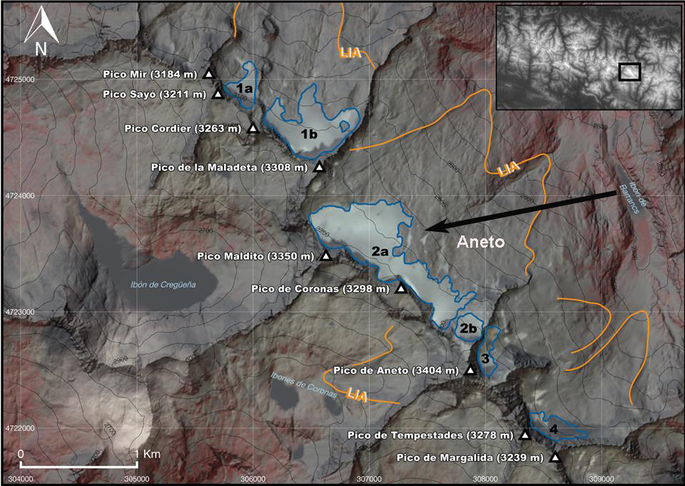
Rico et al (2017) figure indicating LIA area to 2016 for Maladeta and Aneto Glacier, image provided by Eñaut Izagirre @Ernatio
2007 Google Earth image of Aneto Glacier illustrating lack of retained snowcover and the many annual layers exposed by the lack of an accumulation zone.

Sentinel 2 images of Aneto Glacier area in 2017 indicating there is significant remaining snowcover on 8/4 and again by 9/13.
 Dean of Academic Affairs at Nichols College and Professor of Environmental Science at Nichols College in Massachusetts since 1989. Glaciologist directing the North Cascade Glacier Climate Project since 1984. This project monitors the mass balance and behavior of more glaciers than any other in North America.