

6 November 2018
Buguias, Benguet: an excellent landslide video from the Philippines
Buguias, Benguet: an excellent landslide video from the Philippines
An excellent landslide video has been posted onto Youtube. The video was shot on a road at Man-asok near Buguias in Benguet, on Luzon in the Philippines on 4th November. The video was captured by a passenger, Kersee Masillem, who was on a bus that stopped short of the site of the landslide:-
.
The video captures nicely the force of the landslide. Notable are:
1. The rocks that tumble down the slope prior to the main failure. In some cases these are rotating around their short axis, giving very high mobility.
2. The weather conditions at the time of the main failure – this is not a rainfall triggered event.
3. The severe challenge of judging the track of the landslide from the road – the man standing on the barrier was very lucky to escape. The lesson here is to keep well away.
4. The devastating impact of the landslide. The bus driver did well to stop short. It is not unusual for people to be killed as drivers try to pick their way through the debris on the road from the precursory events.
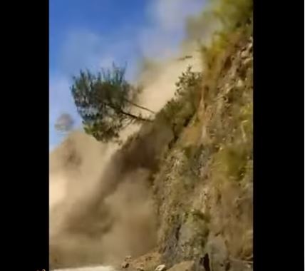
The first part of the main failure phase of the landslide at Buguias, Benguet on Luzon in the Philippines on 4th November 2018. Still from a Youtube video captured by Kersee Masillem.
GMA News has a report about the landslide that indicates that the roof of the bus was struck by a rock.
5 November 2018
Another major glacial debris flow blocked the Yarlung Tsangpo river in Tibet
Another major glacial debris flow blocked the Yarlung Tsangpo river in Tibet
On 17th October 2018 a major debris flow occurred on the Sedong Ri glacier above the Yarlung Tsangpo river in Tibet, one of the tributaries of the Brahmaputra. This flow blocked the river, although the barrier was quickly overtopped, and flow resumed. Colonel Vinayak Bhat (retired), who posts on Twitter as @rajfortyseven, has posted an article on The Print in which he has used satellite imagery to show that a further major surge has occurred in this glacial system, once again blocking the Yarlung Tsangpo, although subsequently the dam has overtopped once more. Fortunately, as we move into winter this area has less cloud than previously, so the system is clearly visible on Planet Labs imagery. This image shows the state of the glacier and the Yarlung Tsangpo on 5th June 2018:-
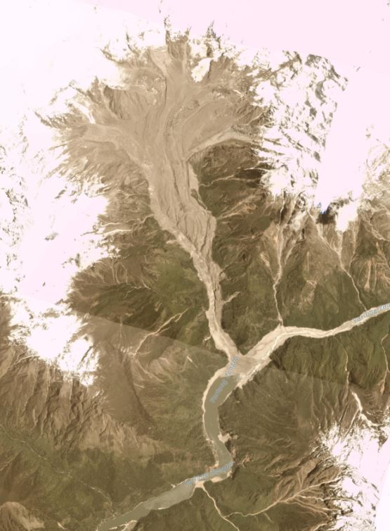
Planet Labs image of the Tsong Ri Glacier and the Yarlung Tsangpo river before the glacial landslides. Planet Labs image dated 5th June 2018. Used with permission.
.
This is the same site as captured by a Planet Labs image on 30th October 2018. Note the bright colours in the areas covered by snow are artifacts of the processing, and have no significance:-
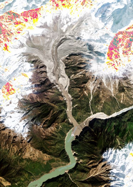
Planet Labs image of the Tsong Ri Glacier and the Yarlung Tsangpo river after the glacial landslides. Planet Labs image dated 30th October 2018. Used with permission.
.
The track of the major glacial debris flows can be clearly seen, originating in the northeast side of the source area and then traveling down to the river to deposit a large amount of debris. The Planet Labs image below shows this source area in more detail:-
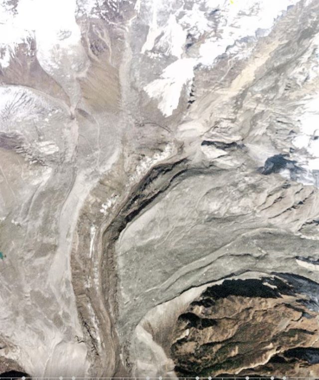
Planet Labs image of the source of the failure above the Tsong Ri Glacier. Planet Labs image dated 30th October 2018. Used with permission.
.
It appears that the glacial debris flows have been triggered by a very large rockslope failure – this appears to be about 1 km in length, and the fresh rock exposed in the base of this landslide can be very clearly seen in the images above. This landslide appears to have then triggered a mass failure of the glacier (or glacial debris), and it has entrained and eroded out a large volume of material. Lower down the channel, as the gradient has reduced, the mechanism has changed from erosion to deposition:-
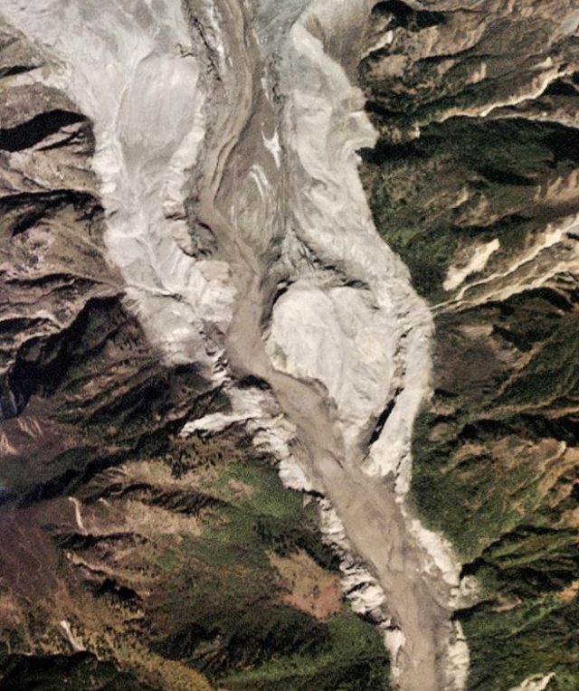
The transition from erosion to deposition on the glacial landslide above the Yarlung Tsangpo. Planet Labs image dated 30th October 2018. Used with permission.
.
Reference
Planet Team (2018). Planet Application Program Interface: In Space for Life on Earth. San Francisco, CA. https://www.planet.com/
30 October 2018
Planet Labs imagery of the 11th October 2018 Jomda County rockslide in Tibet
Planet Labs imagery of the 11th October 2018 Jomda County rockslide in Tibet
In my post on the 11th October 2018 Jomda County rockslide in Tibet, I noted that I had not been able to track down the precise location. In a comment posted today, Margherita Rocchetti has correctly identified the location using Planet Labs imagery. The correct location is: 31°5’0.00″N 98°42’34.00″E. This location yields the following Planet Labs satellite image of the landslide and the associated impounded water:-
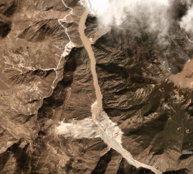
Planet Labs image of the Jonda County rockslide. Planet Labs 3 Band Planetscope scene. Image collected on 30th October 2018, used with permission.
.
The size of the landslide can be seen in the Planet Labs image below, which includes a scale bar in the lower right corner:-
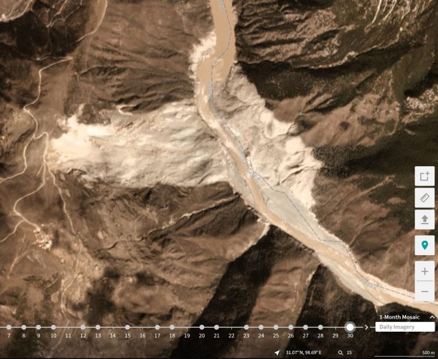
Planet Labs image of the Jomda County rockslide in Tibet. Planet Labs 3 Band Planetscope scene. Image collected on 30th October 2018, used with permission.
.
The landslide from crown to slope toe (i.e. the source length is about 1400 metres long and it is about 700 m wide. There appears to be evidence of super-elevation of the debris up the opposite valley wall, although much of the debris now appears to have been eroded away. There remains some element of blockage of the valley, although the river is flowing, with a substantial volume of water still impounded behind the landslide mass.
There is good Google Earth imagery of the slope that failed, dated 22nd February 2015:-
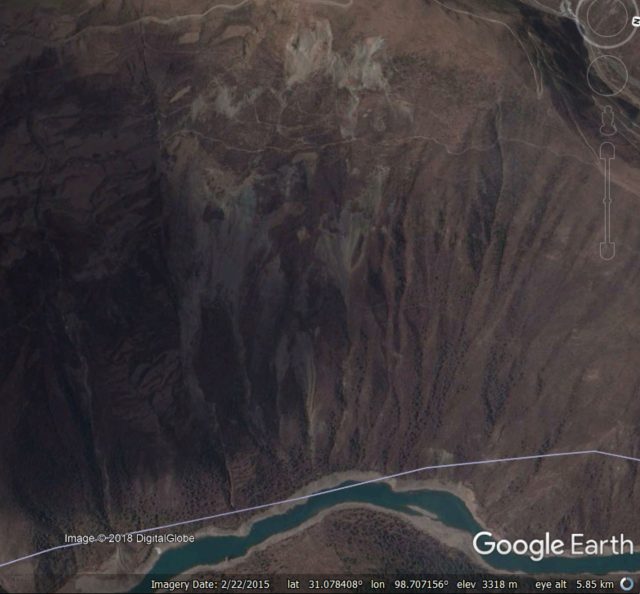
Google Earth imagery of the site of the Jomda County rockslide in Tibet.
.
This appears to show a slope in considerable distress, with deep gullying and signs of tension cracks and deformation at the crown. Zooming in on this area shows a slope that had gone through quite large accumulation of strain:-
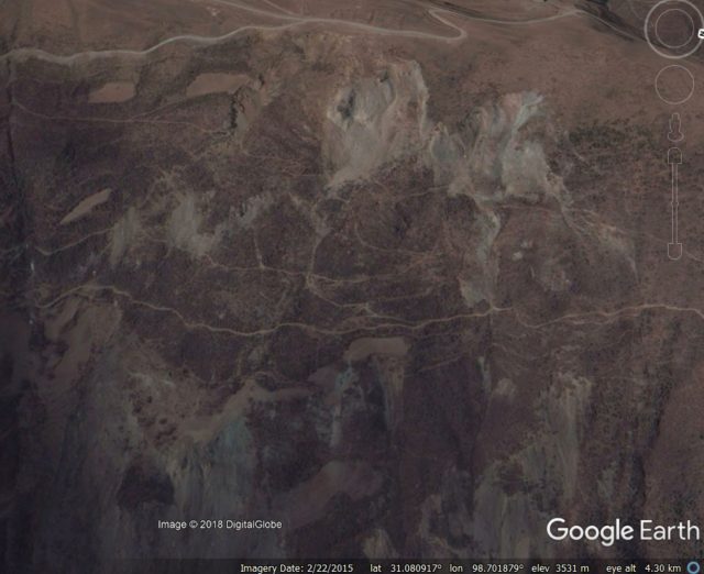
Google Earth imagery of the upper reaches of the site of the Jomda County rockslide in Tibet. Image collected in February 2015.
.
Acknowledgement and Reference
Planet Team (2018). Planet Application Program Interface: In Space for Life on Earth. San Francisco, CA. Planet.com
29 October 2018
Rockfalls from the 25th October 2018 M=6.8 Zakynthos earthquake
Rockfalls from the 25th October 2018 M=6.8 Zakynthos earthquake
On 25th October the M=6.8 Zakynthos earthquake struck offshore the west coast of Greece, at a depth of just 14 km. The USGS Shakemap data is presented in the map below:-
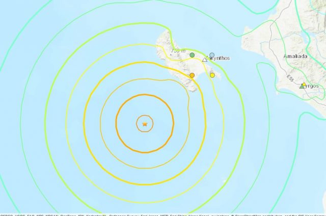
USGS Shakemap data for the 25th October 2018 M=6.8 Zakynthos earthquake.
.
Fortunately, the location of the earthquake offshore limited the impacts, but there are reports of rockfalls on the rugged island of Zakynthos. To date only one image has emerged (as far as I can tell), showing a significant collapse on Myzithres Beach. Ermisnews has this before and after pair of images of the event at Myzithres Beach:-

A major rockfall on Myzithres beach. This collapse was reportedly triggered by the 25th October Zakynthos earthquake. Image via Ermisnews.
Potentially the most significant rockfall occurred on the famous tourist site known as Shipwreck Beach. This area had been subjected to rockfalls prior to the earthquake, but a significant failure appears to have occurred. Unfortunately no images are yet available. Imerazante has a good image of the collapse in September, with appears to have occurred on face-parallel joints:-
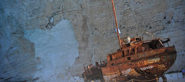
The rockfall scar from the failure at Shipwreck Beach in September 2018. Image via Imerazante.
.
Meanwhile, Neakriti has some images after the September 2018 event:-

The debris from the rockfall on Shipwreck Beach from the September 2018 rockfall. Image via Neakriti.
.
Meanwhile, there are also reports of rockfalls on inland slopes. Neakriti reports that in Panagoula on Zakynthos several houses have been evacuated due to the risk of rockfalls. The aftershock sequence appears to be quite active, so further rockfalls cannot be ruled out, and there will also be a substantial level of hazard in the next major rainfall event. Meanwhile there is also some evidence of liquefaction or foundation problems in the port at Zakynthos, as would probably be expected in an event such as this.
25 October 2018
The Old Fort landslide in British Columbia
The Old Fort landslide in British Columbia
Earlier this month the small community of Old Fort, near to Fort St John in British Columbia, western Canada, was evacuated due to movement of the Old Fort landslide. In addition to potentially threatening some properties, the Old Fort landslide severed the only access road to the community. The landslide is large but quite slow moving. Alaska Highway News has a splendid gallery of images of the landslide released by the Peace River Regional District, which includes this image of the earthflow component of the landslide as it crosses the highway:-
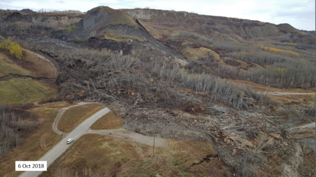
The Old Fort landslide in British Colombia. Image from Peace River Regional District via Alaska Highway News. Note the tension crack on the right side of the hillock in the centre left of the image.
.
This phase of movement of the landslide initiated on 30th September, although there is considerable evidence that it had been moving prior to this date. Local geologists, from Westrek Geotechnical Services, who have been studying the landslide, have diagnosed it as failure in bedrock in the area of a gravel pit operating on the hillslopes above Old Fort. The initial failure triggered a second failure in terrain to the west, allowing the development of an earthflow lobe that followed a pre-existing gully. The slide has a volume of about 8 million m³. This image, also from Peace River Regional District, gives an idea of the scale of the problem. Whilst the main earthflow is clear, the tension cracks and scarps extending across the hillslopes are also evident:-
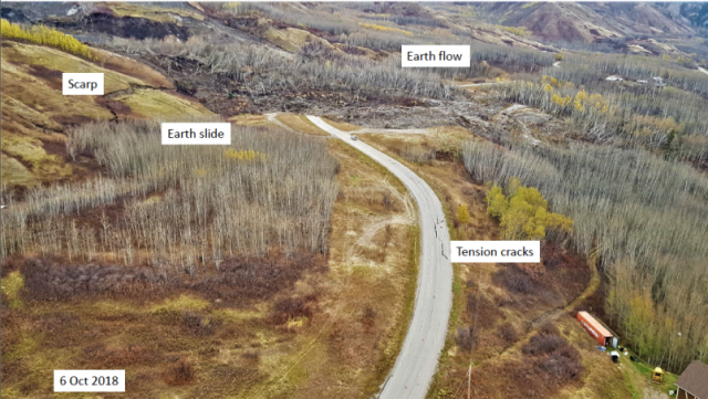
Annoted photograph of the Old Fort landslide in Canada. Image from Peace River Regional District via Alaska Highway News.
.
Whilst this image shows the source area of the current main part of the Old Fort landslide:-
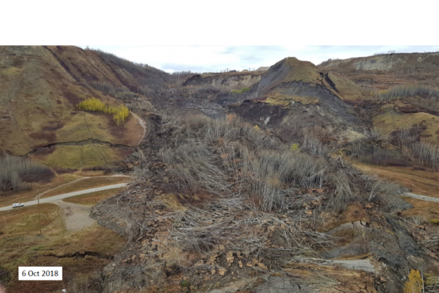
The source area of the Old Fort landslide. mage from Peace River Regional District via Alaska Highway News.
.
A temporary road is currently under construction across the landslide, and work continues to monitor and analyse its behaviour. As usual it is proving very challenging to forecast its likely future behaviour, as has been the case in the Mannen landslide in Norway. Winter is coming, and of course following that will be the snowmelt season in the spring, when groundwater levels could rise. Unfortunately this landslide could prove to be a challenge for some time yet, to the inevitable frustration of the inhabitants of Old Fort.
24 October 2018
George Town: another major fatal landslide in Penang, Malaysia
George Town: another major fatal landslide in Penang, Malaysia
On 19th October a significant landslide occurred in George Town, Penang in Malaysia, killing nine construction workers located in temporary accommodation at the foot of the slope. The landslide, at the Bukit Kukus paired road site, occurred on a large slope that had been cut as part of the highway construction project:-
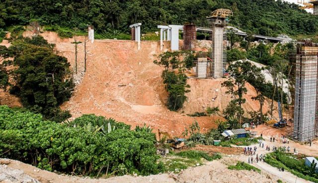
The landslide at Jalan Bukit Kukus in George Town, Penang on 19th October 2018. Image via Sayuti Zainudin and Yahoo News.
.
The landslide appears to be a fairly conventional failure in residual / deeply weathered soil, and reports suggest that it was triggered by heavy rainfall. The accommodation for the workers consisted of a set of containers, offering little protection to the victims:-
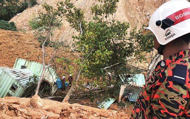
The aftermath of the landslide at George Town in Penang on 19th October 2018. Image via FMT News.
.
Inevitably questions are going to be asked about the construction practices at this site. Aliran has an interesting article about the operations at the site, noting that head of the Perlis, Kedah and Penang Department of Mineral and Geoscience, Azhari Ahmad, has raised questions about the ways in which surface water was being managed. This is a legitimate concern given the nature of the slope behind the cut section. I suspect that questions will also be asked about the ways in which this large cut slope was being drained and supported during the construction works; the ethos must be that all temporary earthworks are stable, so something went badly awry here. And finally, questions will need to be asked about the location of worker accommodation at the toe of a major cut slope.
This landslide is close to the large slope failure in George Town in November 2017, which caused extensive damage to a new residential development site. In October 2017 a major slide happened at Tanjung Bungah, also in Penang, killing 11 workers. Notably, all three landslides occurred during construction.
23 October 2018
Jomda County: a large, valley blocking landslide in Tibet on 11th October
Jomda County: a large, valley blocking landslide in Tibet on 11th October
As I noted in my post yesterday regarding the Yarlung Tsangpo landslide in Tibet, there was another very large landslide event in that region on 11th October 2018. This landslide locked the Drichu / Jimsha River at Bolo Township in Jomda County, although the blockage now appears to have cleared. The landslide was a very substantial rockslide:-
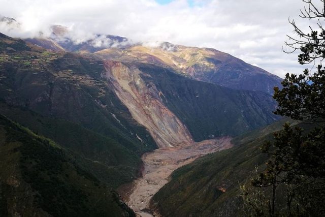
The landslide at Bolo Township in Jomda County, Tibet on 11th October 2018. Image via Caixin.
.
Reports suggest that the landslide occurred at 4 am local time, and fortunately resulted in no loss of life. Fortunately the lake barrier was overtopped and breached within a couple of days, reducing the downstream danger. The landslide appears to have had reasonably high mobility, spreading both upstream and downstream in the main valley, which will have reduced the height of the barrier:-
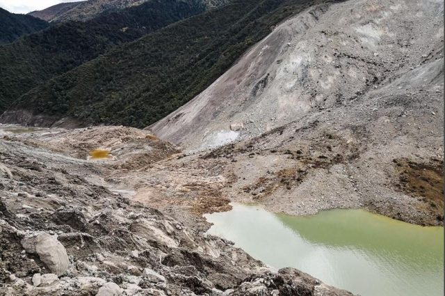
The landslide at Bolo Township in Jonda County, Tibet on 11th October 2018. Image via Caixin.
.
Some reports suggested that there were fears of a second landslide at this site:-
“Even as dangers from a barrier lake formed by a landslide which blocked the Drichu (Chinese: Yangtze River) tributary of Jinsha River at Bolo Township of Jomda County in Tibet’s Chamdo (Qamdo) City receded following a burst through the blockade, another danger keeps growing, reported China’s official Xinhua news agency Oct 14.
“The report cited China’s Ministry of Emergency Management as warning Oct 13 that the possibility of another landslide was growing. It was stated that a 300-metre-long crack had been spotted on the surface of the mountain where the previous landslide had occurred, increasing the risk of the river being cut off again.”
However, no reports that I have seen to date suggest that a second landslide has occurred to date. Unfortunately, as yet I have been unable to track down the precise location of this landslide.
22 October 2018
Yarlung Tsangpo: a large valley blocking landslide in Tibet
Yarlung Tsangpo: a large valley blocking landslide in Tibet
Xinhua reports that on Wednesday of last week (17th October 2018), a very large landslide occurred in Menling County in Tibet, blocking the Yarlung Tsangpo River. The volume of the barrier lake quickly increased, reaching a reported 300 million m³, and thus presenting a substantial hazard. Interestingly, this is the second barrier lake to form in Tibet in a short period, as on 11th October 2018 a further large, valley blocking landslide occurred at Bolo township in Jomda County, also causing a substantial blockage. To have two large valley-blocking slides in such a short period of time is quite surprising.
In the case of the Yarlung Tsangpao landslide, SANDRP reports that the location is in the vicinity of 94.9375° E, 29.7496° N, although it recognises that there is some uncertainty in this position. Unfortunately at present there is too much cloud in the area to validate this with satellite imagery.
Xinhua has this view of the landslide barrier:-
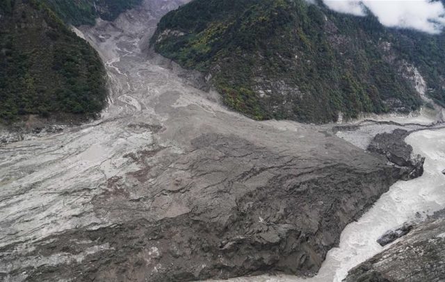
The landslide blocking the Yarlung Tsangpo river in Tibet. Image via Xinhua.
.
Initially the landslide caused a complete blockage of the Yarlung Tsangpo river, but the blockage has now breached. There is some evidence that the overtopping event caused flood damage downstream, but prompt evacuation of the downstream communities appears to have ensured that no lives were lost. This image, also from Xinhua, shows the blockage prior to overtopping:-
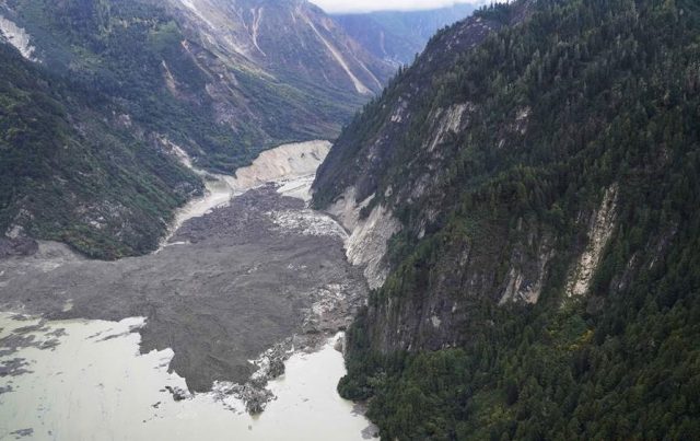
The valley-blocking landslide on the Yarlung Tsangpo river in Tiber. Image via Xinhua,
.
This Xinhua image is particularly interesting, showing the very lower reaches of the landslide deposit and the dried out riverbed:-
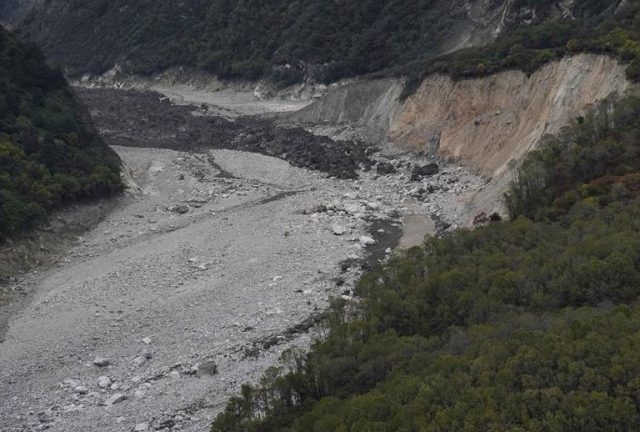
The toe of the landslide at Yarlung Tsango in Tibet. Image via Xinhua.
.
SANDRP quotes a researcher in the area as indicating that this landslide might have been a glacial surge:-
“A researcher who alerted India about the landslides along Yarlung Tsagpo in Dec 2017 said that the Sendapu glacier surged and wasted between September & 13th October, releasing debris that possibly led to the landslide.”
Some sort of glacial event, possibly a rock and ice avalanche that flowed across the glacier surface, akin to the Siachen Glacier event in Pakistan in 2012, appears to have been the cause. We will need satellite imagery to know for certain.
19 October 2018
Landslide tsunamis from the Sulawesi earthquake
Landslide tsunamis from the Sulawesi earthquake
Our understanding of the Sulawesi earthquake continues to improve as more information becomes available. This has shown Twitter at its very best, with a range of people bringing different expertise, and techniques to bear on the problem of what has proven to be a very complex event. I would like to recommend in particular Austin Elliott, John O’Leary, Xiaohua Xu, Eric Fielding and (most impressive of all) Sotiris Valkaniotis, all of whom have been very proactive in interpreting and synthesising the data, and making the information available online.
New videos continue to appear on Youtube. One is particularly interesting, taken from a boat located just offshore when the tsunami struck:-
.
There is so much in this video that it is hard to know where to start. The video opens with a view roughly southwards (corrected from earlier version) up the bay, showing an enormous landslide generated displacement wave from the western side of the bay:-

A landslide tsunami from the Sulawesi earthquake. Still from a video on Youtube.
.
The view then switches to the east side, where another landslide tsunami has been generated:-

A second landslide tsunami generated by the Sulawesi earthquake. Still from a video on Youtube.
.
Incidentally, as the camera pans from one to the other, a third wave, generated from the eastern side of the bay, can also be seen. Meanwhile, in the background the multiple dust plumes generated by landslides in the hills can be seen:-
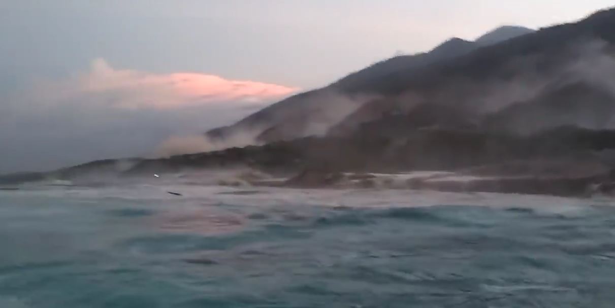
Multiple dust clouds generated by landslides triggered by the Sulawesi earthquake. Still from a video on Youtube.
.
On Twitter, Austin Elliott managed to tie down the location of the boat to -0.8303, 119.8133, and John O’Leary confirmed that there was a landslide at that point.
This video aligns nicely with the remarkable video taken by a pilot of an aircraft that had just left Palu airport when the earthquake struck. This video also shows the generation of landslide tsunamis by the Sulawesi earthquake:-

A landslide generated by the Sulawesi earthquake. Still from a video tweeted by Gerry Soejatman.
.
We have never had such a detailed and nuanced view of the way that coastal landslides generate local tsunamis during an earthquake.
15 October 2018
Sigi Biromaru: terrifying footage of lateral spreading during the Sulawesi earthquake
Sigi Biromaru: terrifying footage of lateral spreading during the Sulawesi earthquake
Sigi Biromaru is a suburb of Palu located on the eastern side of the valley. Whilst most of the focus in the two weeks since the Sulawesi earthquake has been on the flowslides, it is easy to forget that other slopes also went through significant lateral spreading during the mainshock. In an initial (amazing) analysis of optical imagery collected by Sentinel-2, Sotiris Valkaniotis of the Aristotle University of Thessaloniki has shown that there was extensive lateral spreading on the eastern side of the fault. To confirm this, a video has been posted on Youtube that shows the development of very significant lateral spreading during the earthquake. In this case it appears that the lateral spreading did not transition into the type of flowslide seen elsewhere in Palu, but the level of damage is very substantial. The original video is available on Youtube:-
.
Unfortunately the camera is rotated, which makes watching the video quite challenging. There is another version that is easier to watch, albeit with an irritating backing track:
.
The astonishing thing about this video is that the lateral spreading, as indicated by the large tension cracks in the road, develops as the video runs. These two screenshots, taken less than a minute apart, show one of the fissures opening:-

Sigi Biromaru lateral spreading: one of the tension cracks starting to develop. Screenshot from a video posted to Youtube.
.
A few seconds later the fissure looked like this:-

Sigi Biromaru: the aftermath of the Sulawesi earthquake. Screenshot from a video posted to Youtube.
.
Fortunately in this case full liquefaction, if that is what occurred to generate the flowslides, did not occur. The magnitude of the damage is extraordinary though, illustrating the magnitude of the challenges that lie ahead in getting this area back on its feet:-
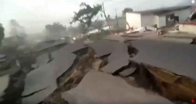
The aftermath of lateral spreading at Sigi Biromaru, after the Sulawesi earthquake. Screenshot from a video posted to Youtube.
.
In interesting element of this disaster will be understand why this slope did not go to the full, flowslide-generating failure seen at Balaroa and Petobo. It is very fortunate that this did not occur.
 Dave Petley is the Vice-Chancellor of the University of Hull in the United Kingdom. His blog provides commentary and analysis of landslide events occurring worldwide, including the landslides themselves, latest research, and conferences and meetings.
Recent Comments