24 October 2017
The Tanjung Bungah landslide: a very challenging site
Posted by Dave Petley
The Tanjung Bungah landslide: a very challenging site
In Malaysia, the fall out from the Tanjung Bungah landslide, which killed 11 construction workers in Penang on Saturday, continues unabated. The Penang State Government is reported to have stated that the cause of the landslide was human error. That may be true, but it is far from clear as to what this means. Was there a failure to understand the ground conditions properly? Or was the slope design incorrect? Or was there a failure to construct to the agreed design? Errors can occur at any stage; often there are multiple small elements. It is also important to emphasise that human error does not necessarily mean that someone was negligent (although this is sometimes the case).
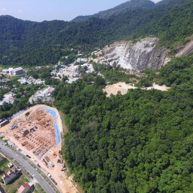
Meanwhile, the pressure group Penang Hills Watch, which tries to raise awareness of the damage that is being done to the upland areas of Penang by inappropriate development, has been expressing concern about the development at the site of the Tanjung Bungah landslide for some time. Their online map of projects notes slope clearing at this location, which began is 2015, and includes a photograph of the initial slope cutting work. In June 2017 they published the image below on their Facebook site, providing a panoramic view of the location of the Tanjung Bungah landslide:-

Panoramic image of the site of the Tanjung Bungah landslide, taken in June 2017. Image from Penang Hills Watch
.
With the combination of the quarry on the steep slopes behind the site, tipping upslope, and other construction in the vicinity, this looks like a very complex location in which to undertake a large development with extensive slope excavation. That is not to say that development was impossible of course, and nor that it should necessarily have been precluded. However, it does suggest that the works required a great deal of care. I continue to wonder as to the level of slope stability measures that were in place on that steep cut slope. I am sure that this will be a key focus in the investigation.


 Dave Petley is the Vice-Chancellor of the University of Hull in the United Kingdom. His blog provides commentary and analysis of landslide events occurring worldwide, including the landslides themselves, latest research, and conferences and meetings.
The above photo is a side on view of the hillside. Identifiable are three paleo landslides, in classic ridge/valley formation, (geomorphology). The black algae in the white rock quarry indicate that the quarry is somewhat old, certainly greater than four years, the age at which algae have been observed to have taken over the cliff face of teh Great Maribojoc debris slide on Bohol Island, from the 15 October 2017 M7.1 Earthquake. The red/yellow colours of the landslide soil are interesting. Is the soil laterite? Certainly it is derived by weathering from parent volcanic rock. . What are the soil strengths, shear and phi? Is there a Geotechnical testing laboratory in Malayasia?
Where this happened? What date? I didn’t get any help from this
[Follow the first link. D]