
22 November 2019
Deep-seated gravitational slope deformations: Piz Dora
Deep-seated gravitational slope deformations: Piz Dora
Deep-seated gravitational slope deformation (DGSD) is one of the most poorly recognised, but most dramatic, types of landslide. Mauro Soldati defined them as follows:-
A deep-seated gravitational slope deformation (DGSD) is a gravity-induced process affecting large portions of slopes evolving over very long periods of time. A DGSD may displace rock volumes of up to hundreds of millions of cubic meters, with thicknesses of up to a few hundred meters…Deep-seated gravitational slope deformations (DGSDs) are not considered hazardous phenomena because they evolve very slowly. However, they must not be neglected when defining slope instability in a territory and the related hazard implications. Despite their slow deformation rates, DGSDs may cause damage to surface and underground (e.g., tunnels) structures. In addition, they may evolve into faster mass movements or favor collateral landslide processes.
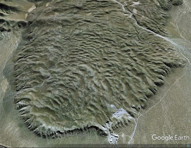
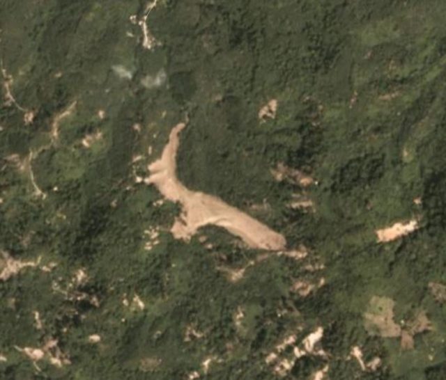
A really nice example is described in an article in Engineering Geology (Agliardi et al. 2019) at Piz Dora in Switzerland. This landslide, which is located at 46.601, 10.350, is shown very nicely in the Google Earth image below:-
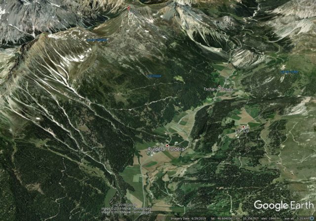
Google Earth image of the Piz Dora deep-seated gravitational slope deformation in Switzerland. The view is towards the west.
.
There is an excellent interpretation of the geomorphology and structure of the Piz Dora DSGSD is provided by Agliardi et al. (2019):-
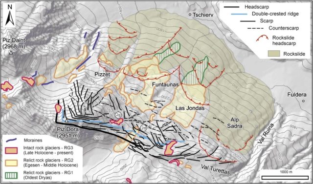
A geomorphologic and morpho-structural map of the Piz Dora deep-seated gravitational slope deformation. Map from Agliardi et al. (2019).
.
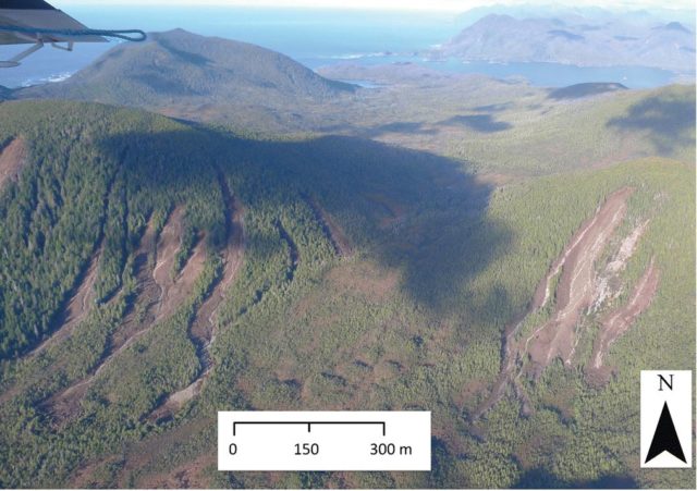
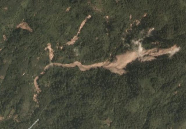
As the map shows, the entire mountain side is moving on a deep-seated shear surface (or on multiple shear surface), creating a set of scarps and counter scarps high on the hillside. One of the largest ones is seen below:-
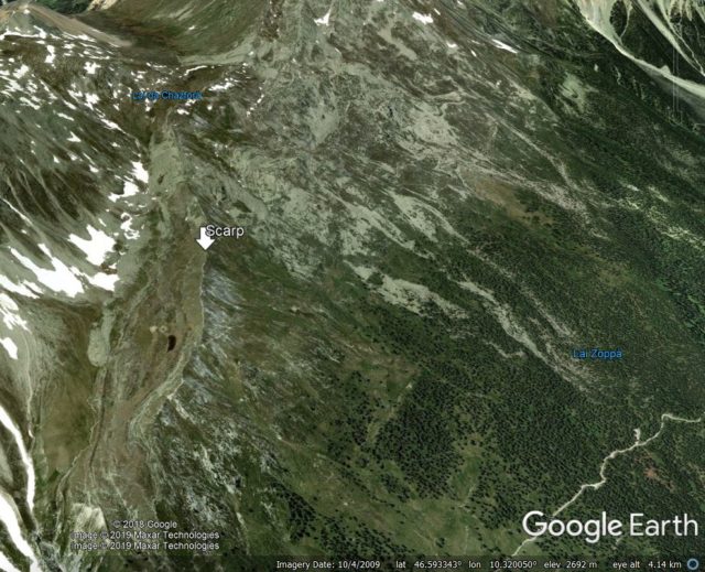
A counter scarp on the Piz Dora deep-seated gravitational slope deformation. Image from Google Earth.
.
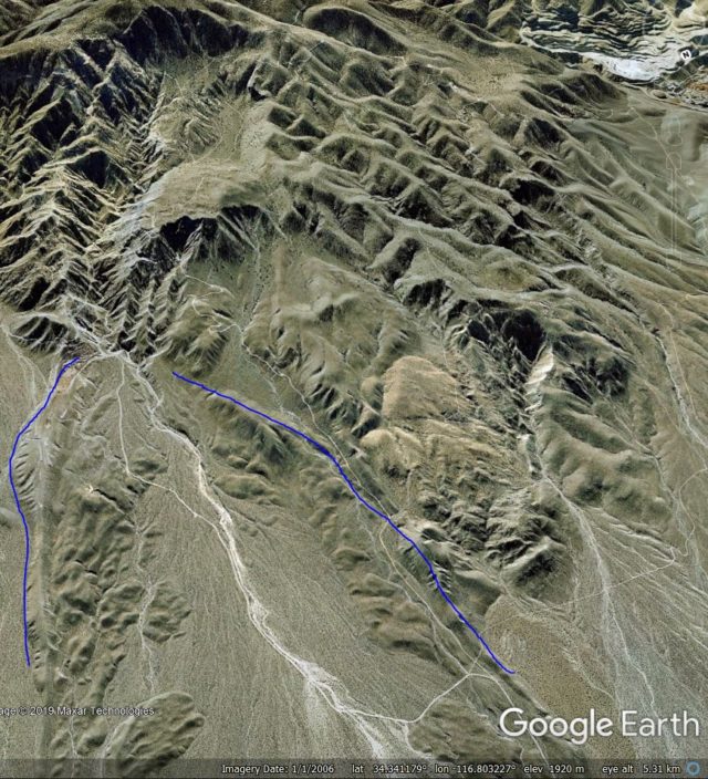
Downslope from the scarp is a large displaced mass. Smaller scarps extend across the slope – at the main peak (Piz Dora itself, there is a pin to mark it in the first image) the scarps extend right the way through the crest of the slope:-
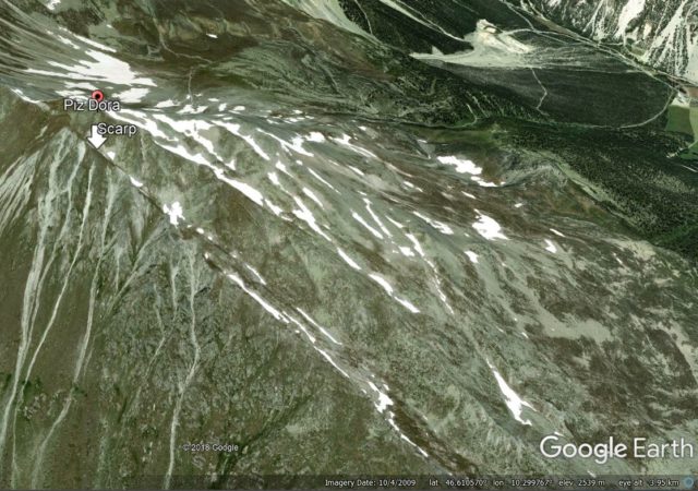
Google Earth image of the rear scarps of the Piz Dora deep-seated gravitational slope deformation.
.
The lower part of the mobile slope consists of a series of smaller, but from insignificant, rockslides, mostly covered in forest.
Agliardi et al. (2019) have measured the rate of movement of the Piz Dora deep-seated gravitational slope deformation. They found that, as is usual for this type of landslide, the mass creeps continuously at low rates. Movement rates vary across the landslide, with a maximum velocity in the order of 30 – 100 mm per year.
These types of landslides are very common in high mountain areas. Because they do not generate significant levels of hazard, they are poorly investigated and are rarely reported. However, they are one of the most fascinating types of landslide, and they deserve more attention.
Reference
Federico Agliardi, Federico Riva, Marta Barbarano, Stefano Zanchetta, Riccardo Scotti and Andrea Zanchi. 2019. Effects of tectonic structures and long-term seismicity on paraglacial giant slope deformations: Piz Dora (Switzerland). Engineering Geology, 263, 105353. https://doi.org/10.1016/j.enggeo.2019.105353.
19 November 2019
Landslides triggered by the Mw=7.8 Haida Gwaii earthquake in Canada
Landslides triggered by the Mw=7.8 Haida Gwaii earthquake in Canada
On 27 October 2012 the Mw=7.8 Haida Gwaii earthquake struck off the coast in British Columbia in Canada. This was a shallow earthquake with a dominantly thrust-type mechanism, which would be expected to generate substantial numbers of landslides if it occurred directly under hilly terrain. In this case, a comparatively small area of Haida Gwaii (formerly the Queen Charlotte Islands) was affected by significant shaking. The impacts in terms of landslides are documented in a new paper (Barth et al. 2019) published in the journal Landslides. This is a particularly interesting case as the study area, which extends over about 1350 km2, consists of undisturbed, forested hillsides. This is important for two reasons:
- It removes the effects of human activity on landslide susceptibility, giving a dataset that is less complex to interpret than has been the case elsewhere;
- The contrast between native forest and the bear rock / soil of a landslide makes mapping comparatively straightforward using satellite imagery.
Thus, this is a key event for understanding the landslide impacts of large earthquakes.
In total Barth et al. (2019) have mapped 244 landslides triggered by the earthquake. The authors provide an example of these landslides in the area of Gowaia Bay in Haida Gwaii:-
Landslides from the Mw=7.8 Haida Gwaii earthquake. Image from Barth et al. (2019).
.
Barth et al. (2019) have looked at multiple epochs of satellite imagery, and examined the rates at which landslides occur. They find that:
- Prior to the earthquake, the average rate was 1.44 new landslides per year per 100 km2 in the study area;
- The 244 landslides triggered in the earthquake dramatically increases this to 18.1 new landslides per year per 100 km2
- In the three years after the earthquake the rate of new landslides decreased to 1.93 per year per 100 km2
- And finally, in the period from 2016 to 2018 this reduced to 1.0 new landslides per year per 100 km2.
So, it is clear that the earthquake caused a very dramatic spike in the landslide rate and, as has been established elsewhere, an above average rate continued in the post-seismic period, before settling back down to the background rate. This is a dataset that should allow a more detailed understanding of the control on landslides from different physical parameters, and thus it is an important new dataset in the growing catalogue of coseismic landslide inventories.
Reference
Barth, S., Geertsema, M., Bevington, A.R. et al. 2019. Landslide response to the 27 October 2012 earthquake (MW 7.8), southern Haida Gwaii, British Columbia, Canada. Landslides. https://doi.org/10.1007/s10346-019-01292-7
18 November 2019
90 years after the 1929 Grand Banks earthquake: the hazards of submarine landslides on the western North Atlantic passive margin
90 years after the 1929 Grand Banks earthquake: the hazards of submarine landslides on the western North Atlantic passive margin
On 18 November 1929 (90 years ago today) the Mw=7.2 Grand Banks earthquake triggered a submarine landslide off the coast of Newfoundland, which in turn generated a significant tsunami. Whilst the shaking damage was limited, the tsunami struck the Burin Peninsula in Newfoundland, Canada, killing 28 people:-
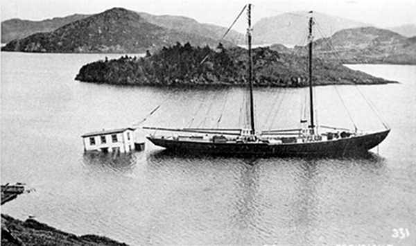
The aftermath of the 1929 Grand Banks Earthquake. This image shows The home of Steven Henry Isaacs of Port au Bras, which was towed back to shore after being swept out to sea by the tsunami and anchored to the fishing schooner Marian Belle Wolfe. Image via Natural Resources Canada.
.
Considerable work has been undertaken on that particular event since the disaster. It is thought that the earthquake triggered a submarine landslide with a volume of about 200 cubic kilometres, which in turn triggered the tsunami. However, the frequency of such events has been unclear until now.
Over the last few years there has been a dramatic improvement in the understanding of the hazards associated with submarine landslides, and the tsunamis that they can generate, on the margins of ocean basins, driven by deep ocean exploration. Indeed, even this weekend The Daily Express carried an article featuring the work (inevitably in a sensational style) of David Tappin from the British Geological Survey, explaining that tsunamis generated by submarine landslides may be more common on the coasts of the UK than had been understood previously.
In a new, very timely, paper published in the journal Geology (Normandeau et al. 2019), and available Open Access, report on the results of mapping with multibeam bathymetry, supported with the analysis of cores, off the coast of eastern Canada. This map shows the location of this work:-
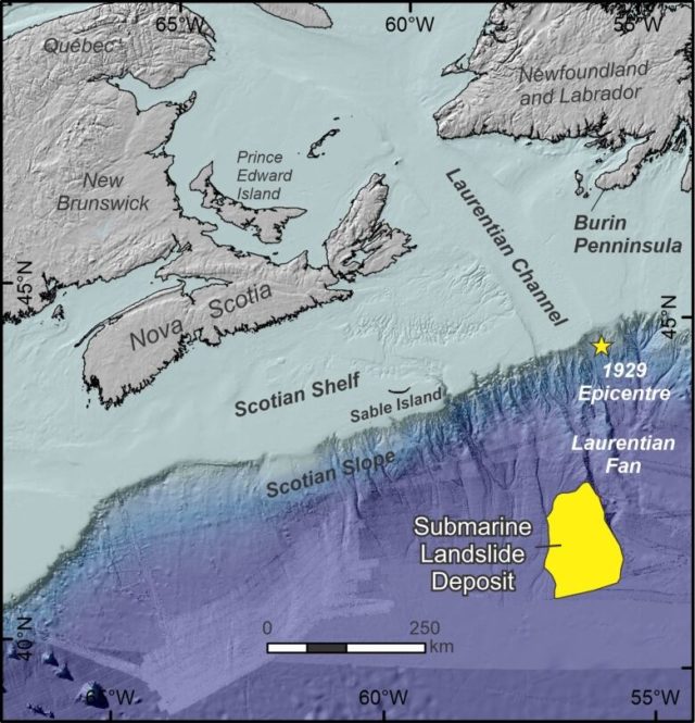
The location of the landslide deposit, and the epicentre of the 1929 Grand Banks earthquake. Image from Natural Resources Canada, via CBC.
.
The researcher found extensive turbidite deposits, which they interpret as having been generated by submarine landslides similar to the 1929 Grand Banks earthquake event, more than 200 km from the coast and at about 4000 metres water depth. Analysis of these deposits suggests that they were formed in a series of landslides, representing four events over the last 4,000 years, with a total volume in the range of 300-400 cubic kilometres.
This study indicates that large submarine landslides may be more common on this section of the ocean basin than had been previously considered. The implications of this are not entirely clear without further research, as Normandeau et al. 2019) highlight:
“Although these landslide events occurred far from the coast, there are considerations for impacts to seabed infrastructure. Three submarine cables cross the Laurentian Fan region, all located on the large Laurentian Fan levee landslide described here. Additionally, the Canadian Atlantic margin is an area of active oil and gas exploration, with recent exploration wells drilled in water depths >2000 m and a potential for deepwater oil production. The tsunamigenic potential of these newly identified landslides is unknown, but the potential threat to coastal communities of eastern North America should not be discounted. A reevaluation of submarine-landslide risk across the western North Atlantic margin is recommended, and would require more systematic seafloor mapping, analysis of the distal record of large events, targeted slope stability analysis, and numerical modeling of landslide tsunamigenic potential.”
This is an excellent study, casting further light on these huge, potentially hazardous landslides. It is clear that they need to be investigated in more detail.
Reference
Alexandre Normandeau, D. Calvin Campbell, David J.W. Piper and Kimberley A. Jenner. 2019. Are submarine landslides an underestimated hazard on the western North Atlantic passive margin?. Geology 47 (9): 848–852. doi: https://doi.org/10.1130/G46201.1
15 November 2019
The Blackhawk landslide
The Blackhawk landslide
The Blackhawk landslide is without doubt one of the most impressive rock avalanches on Earth. It is located at 34.393, -116.773 in the Lucerne Valley on the escarpment that divides the San Bernardino Mountains to the south from the Mojave Desert to the north, in California. This is a Google Earth image of the landslide source and deposit:-
A Google Earth image of the Blackhawk landslide in the Lucerne Valley of California.
.
As the image shows, this is a landslide on a very grand scale. With an estimated volume of about 300 million cubic metres, the landslide extends over a distance of about 9 km from the crown to the toe, with a deposit that is up to 2 km wide and up to 30 m thick. The fall height is estimated to be about 1,200 m in total, making this a highly mobile landslide.
The event is not recent. Dating of the deposit suggests that it may have occurred about 18,000 years ago, although there is huge uncertainty in that date. However, in the dry desert environment of inland California the landslide is exceptionally well-preserved, and of course the landslide mass contrasts with the valley floor, rendering the mass highly visible.
This is a landslide that is surprisingly poorly investigated. There is a very nice PhD thesis from 1959 by Ronald Shreeve that is online, which describes the geology and mechanics of the landslide. This was in the days in which a PhD thesis could be just 84 pages long (there are lessons to learn from that!). Shreeve describes the geology, and tries to explain the exceptional mobility of the landslide, hypothesizing that it may have moved on a lubricating basal air layer. There is also a nice blog article about it on the excellent Looking for Detachment blog. Finally, there is a book chapter from 1978 about the landslide by Brann Johnson, but even the University of Sheffield subscription to Science Direct does not provide access to that one.
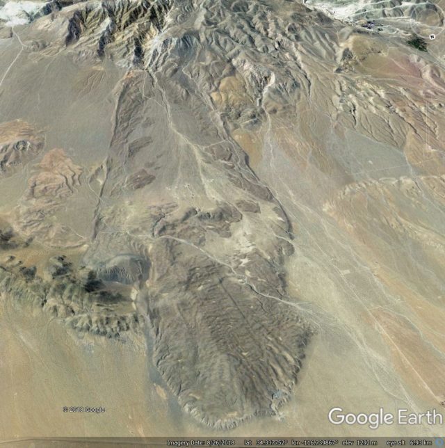
This is landslide that would really benefit from a revisit using up to date techniques. There is exquisite hummocky morphology in the landslide deposit, captured well in the this 2006 Google Earth image:-
Google Earth image of the Blackhawk landslide in California
.
And to me, the now dissected landslide source area suggests that this might have been quite a complex event too. This is a Google Earth image of the landslide scar area; I have annotated the approximate boundaries of the upper part of the deposit:-
Google Earth image of the source area of the Blackhawk landslide.
.
The implication appears to be a highly unusual morphology of the landslide scar. It is not clear to me how the mechanics of this part of the landslide motion would have operated – is there a large volume of stalled material still within the scar area?
Acknowledgement and footnote
Many thanks to my friend funkenbeachin for pointing out this landslide, and for the discussions about it. He has hypothesised that there may be other events in this area as well – take a look at the image below. It is not hard to believe that there is more than one landslide deposit on the valley floor:-
Wide angle Google Earth view of the valley floor around the Blackhawk landslide
14 November 2019
Lokeberg: an interesting quick clay slide triggered by piling in Western Sweden
Lokeberg: an interesting quick clay slide triggered by piling in Western Sweden
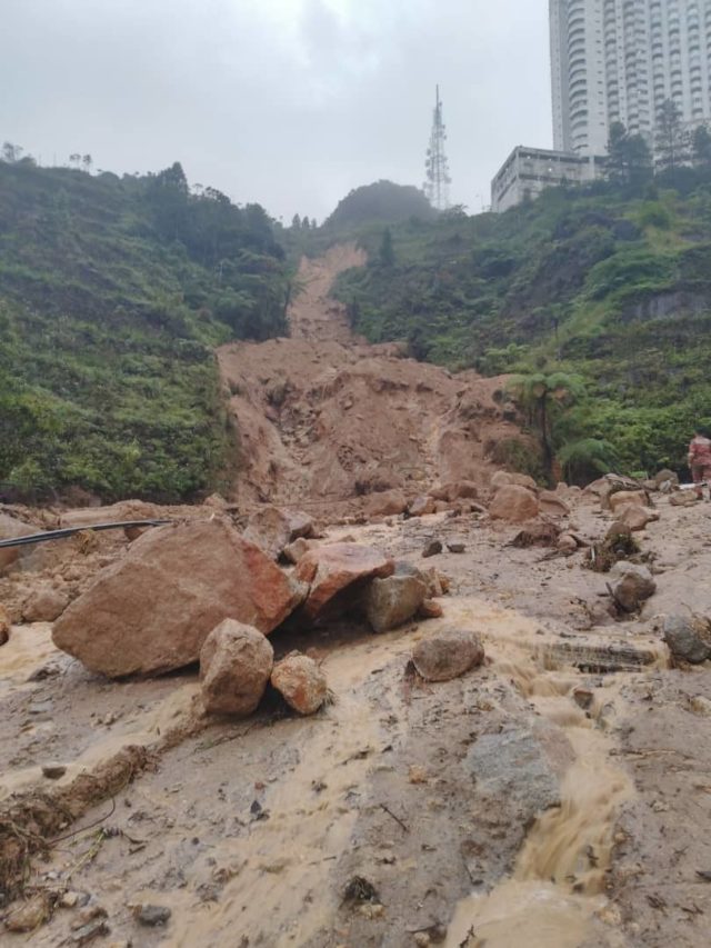
In Lokeburg in western Sweden a significant landslide occurred yesterday (13 November 2019). Anton Larsson kindly highlighted this event to the community via Twitter, posting photographs of the aftermath.
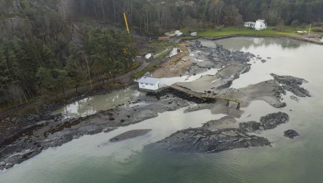
The aftermath of the quick clay landslide at Lokeburg in Sweden. Image by Linus Olsson via Sverige Radio.
.
The large volume of displaced material under the now deformed and moved jetty is clear. In the trees on the left side of the image is a nicely formed rear scarp of the landslide. But note in the trees there is also clear evidence of a crane, and on the road there is a truck. News reports in Sweden link the landslide to the construction of a house at this location.
The location of the landslide is 57.903, 11.753, and there is good Google Earth imagery of the site:-
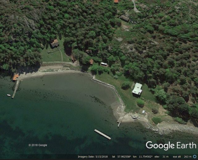
A Google Earth image of the site of the quick clay landslide at Lokeburg in Sweden.
.
Fortunately, no-one was killed or injured in the landslide. Anton Larsson tweeted to provide a possible explanation:
“Based on news reports, the workers were piling the area to ensure stability ahead of a rather luxurious beach house being built.”
However, subsequent reports have confirmed that it was not piling, but ground improvement through lime/cement-stabilization (which makes more sense in terms of the equipment present at the site). Thanks to Carolina for her helpful comment below that has clarified this point.
The most likely explanation for this landslide is that it is a quick clay slide. Quick clays are materials laid down in glaciomarine conditions that are “sensitive“, meaning that their strength can abruptly reduce when subjected to rapid changes in stress. The effect might be very local initially, but spreads through the deposit rapidly as the stress change propagates. This can lead to large-scale failures.
In this case a good working hypothesis would be that the piling operation generated the abrupt stress change that initiated the failure. Fortunately, the extent of the quick clay deposit was not particularly large, so the failure was contained.
12 November 2019
The 2019 Cotabato earthquakes: the Barangay Bato landslide cluster
The 2019 Cotabato earthquakes: the Barangay Bato landslide cluster
Yesterday I highlighted a significant landslide cluster triggered by the 2019 Cotabato earthquakes, at Barangay Buhay. I indicated that there is another cluster on the imagery, located at Barangay Bato (6.84, 125.16).
This is a Planet Labs satellite image, collected on 8 November 2019, providing an overview of this significant landslide cluster:-
The Barangay Bato landslide cluster, triggered by the2019 Cotabato earthquakes. Planet Labs PlanetScope image, captured on 8 November 2019. Copyright Planet Labs, used with permission.
.
There are several hundred landslides in this cluster, located over an approximately 5 x 5 km area. Most of the landslides appear to be shallow disrputed slides on steeper terrain. There are two larger landslides in the cluster. On the west side there is a large rockslide close to Barangay Bato itself:-
Planet Labs image of the large rockslide located close to Barangay Bato, triggered by the Cotabato earthquakes. Planet Labs PlanetScope image, captured on 8 November 2019. Copyright Planet Labs, used with permission.
.
This landslide was extensively photographed in the aftermath of the earthquake:-
An aerial photo of a massive landslide close to Barangay Bato, triggered by the 2019 Cotabato earthquakes.Photo courtesy of Pfc. Jacil Joe Tupa 10th ID-ERC, via the Manila Bulletin.
.
In the northeast of this cluster, there is another largish (approximately 300 m long) landslide, although it is difficult at present to fully understand this slide:-
Planet Labs image of a large rockslide located in the Barangay Bato landslide cluster, triggered by the Cotabato earthquakes. Planet Labs PlanetScope image, captured on 8 November 2019. Copyright Planet Labs, used with permission.
.
The other landslides are much smaller, but there are large numbers throughout this cluster. The next step is of course to relate these two clusters to the actual locations of the earthquakes that occurred in the sequence. It will be interesting to see which earthquakes triggered landslides, and which did not.
Reference
Planet Team (2019). Planet Application Program Interface: In Space for Life on Earth. San Francisco, CA. https://www.planet.com/
11 November 2019
Planet Labs images of landslides triggered by the 2019 Cotabato earthquakes in the Philippines
Planet Labs images of landslides triggered by the 2019 Cotabato earthquakes in the Philippines
Planet Labs satellite images have now become available showing at least some of the landslides triggered by the 2019 Cotabato earthquakes sequence in the Philippines, which I highlighted last week. Cloud is still affecting some of the area, so the picture is not yet fully clear, but there is sufficient detail to see at least two large clusters of landslides. Below is an overview image, based on an image collected on 8 November 2019, of one of the clusters (located at 6.960, 125.200). I’ll call this group of landslides the Barangay Buhay cluster; the other cluster I have found is at Barangay Bato (located at 6.84, 125.16). I will endeavour to feature the other later this week.
Planet Labs image of the Barangay Buhay cluster of landslides triggered by the Cotabato earthquakes. Planet Labs PlanetScope image, captured on 8 November 2019. Copyright Planet Labs, used with permission.
.
There are two features of note here. One is the c. 1 km long landslide at Barangay Buhay in Makilala, North Cotabato, which is shown in a photograph in an article about survivors of the earthquake, published in Minda News. The article details the survival of an agricultural worker, who was buried up to his neck by one of the landslides, but I think this was probably at Barangay Bato.
Planet Labs image of one of the largest landslides triggered by the Cotabato earthquakes. Planet Labs PlanetScope image, captured on 8 November 2019. Copyright Planet Labs, used with permission.
.
To the east is a large cluster of landslides, the extent of which is not fully covered by the imagery. This cluster, which extends for at least 5 km from east to west and 3 km from north to south, contains a large number of landslides triggered by the Cotabato earthquakes.:-

Planet Labs image of the Barangay Buhay cluster of landslides triggered by the Cotabato earthquakes. Planet Labs PlanetScope image, captured on 8 November 2019. Copyright Planet Labs, used with permission.
.
The Barangay Bato cluster of landslides, triggered by the Cotabato earthquakes, is also large, so watch this space…
Reference
Planet Team (2019). Planet Application Program Interface: In Space for Life on Earth. San Francisco, CA. https://www.planet.com/
6 November 2019
Genting: a major landslide in Malaysia
Genting: a major landslide in Malaysia
Today a major landslide occurred in the Genting Highlands of Malaysia, a popular tourist area. Fortunately, there are no reports of casualties, although this appears to have been a near miss. The best image that I have found of the source of the landslide is this one, posted to Twitter by Bernama:-
The major landslide in the Genting Highlands of Malayasia on 6 November 2019. Image posted to Twitter by Bernama.
.
The landslide appears to have been quite mobile, as a channelised flow. Some of the debris has left the channel and flowed down the road:-
The aftermath of the major landslide in the Genting Highlands of Malaysia on 6 November 2019. Images courtesy of Facebook/Germit Singh and Info Roadblock JPJ/POLIS via Today Online.
.
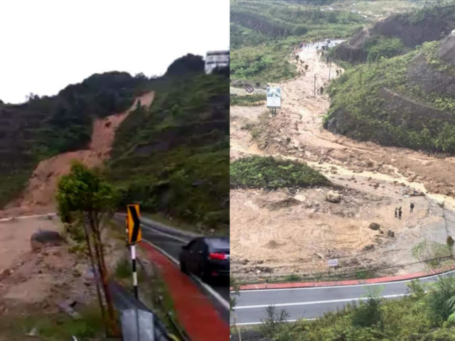
News reports suggest that the landslide was triggered three hours into a major rainstorm in the area. The images suggest that this started as a slip in residual soil that channelised. The volume of debris has overwhelmed the road – it is not clear to me that there was an appropriate culvert in place. Such landslides are common in tropical areas such as Malaysia, and they are of course very hazardous. I note also though that the images suggest that the slope may have been modified in places.
Perhaps the most interesting aspect of this landslide is that one of the surge events was captured on a mobile phone video:
<a href="https://www.youtube.com/watch?v=MtBMn_sr7dM">Youtube</a>.
The extreme mobility of the landslide is clear, and it is interesting that the landslide appears to have occurred as a series of events. This is not obvious from the morphology of the scar and the deposit.
Google Earth imagery of this site is not particularly good, but this image from 2002 suggests that this was not the first landslide at this location:-
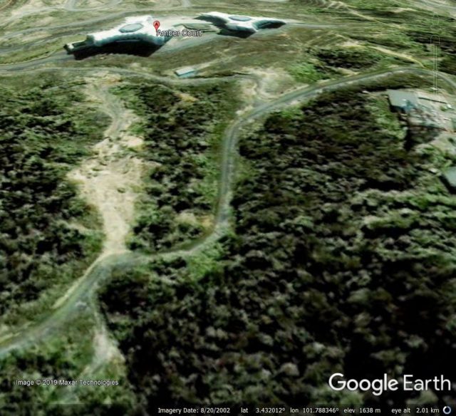
Google Earth imagery from 2002 of the site of the major landslide in the Genting Highlands of Malaysia on 6 November 2019.
.
The landslide is at 3.429, 101.787 if you would like to take a look.
5 November 2019
The Tagarma rock avalanche in the Pamir-western Himalayan syntaxis of the Tibetan Plateau
The Tagarma rock avalanche in the Pamir-western Himalayan syntaxis of the Tibetan Plateau
The Tagarma rock avalanche is an ancient but beautifully-preserved landslide located on the Tibetan Plateau at 38.081, 75.185. This large landslide has recently been described in a paper (Wang et al. 2019) published in the journal Landslides. This is an interesting landslide in that it is located in the so-called Pamir-western Himalayan syntaxis, a major kink in the tectonic boundary that runs through the Himalayas. As such, this is an area of high seismicity – in 1895 the area was struck by the Mw≈7.0 Tashkorgan earthquake for example. As this is an area of low rainfall, Wang et al. (2019) conclude that this rock avalanche was probably triggered by an ancient earthquake, although the date of this is unknown.
The landslide can be seen in the Google Earth image below:-
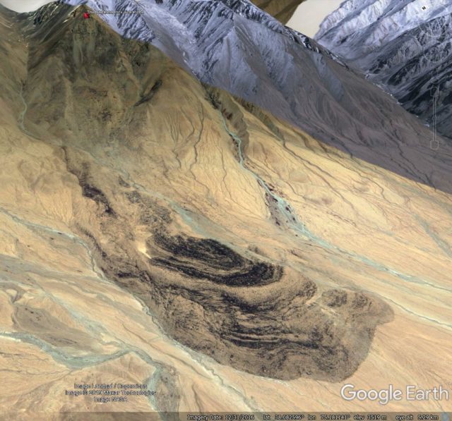
A Google Earth image of the Tagarma rock avalanche in Tibet.
.
I have indicated the location of the crown of the landslide with a red marker, whilst the toe of the landslide, in the foreground, can be seen to have some intricate flow type structures. According to Wang et al. (2019), the landslide is 5,430 metres from crown to toe, with a vertical elevation change of 1,510 metres. The estimated volume is 9.6 million m³. These statistics suggest that this was a highly mobile rock avalanche.
As mentioned above, this rock avalanche has complex structures in the landslide deposit. In the dry Tibetan climate these are beautifully preserved:-
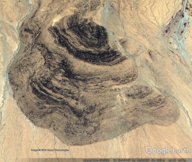
Google Earth image of the deposit of the Tagarma rock avalanche in Tibet
.
Based on detailed analysis of the deposit, Wang et al. (2019) suggest that the Tagarma rock avalanche started as a planar slide in the source area, and then transitioned into an extensional slide, in which the front of the landslide moved more rapidly than the rear portion. Lower on the slope, the landslide encountered increased basal resistance, and thus transitioned into a compressive phase that generated the complex structures seen in the deposit. During this phase the landslide also went through some lateral spreading.
Reference
Wang, YF., Cheng, QG., Yuan, YQ. et al. 2019. Emplacement mechanisms of the Tagarma rock avalanche on the Pamir-western Himalayan syntaxis of the Tibetan Plateau, China. Landslides. https://doi.org/10.1007/s10346-019-01298-1
4 November 2019
Cotabato, Philippines: large landslides from the series of earthquakes in October 2019
Cotabato, Philippines: large landslides from the series of earthquakes in October 2019
In the Philippines, Cotabato in Mindanao has been hit by a series of substantial earthquakes in recent weeks, including a M=6.3 event on 16 October, an M=6.6 event on 29 October and an M=6.5 earthquake on 31 October. These earthquakes have caused substantial levels of damage, and have triggered landslides in the hilly terrain.
DOST-PHIVOLCS has published a graphic showing two of the larger landslides triggered by the 29 and 31 October earthquakes. This appears to show two large slope failures:-
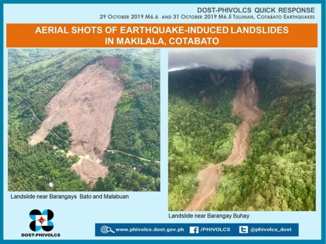
Landslides triggered by the October 2019 earthquake sequence in Cotabato, Philippines, Image created by DOST-PHIVOLCS
.
The image appears to show, on the left, a large, mostly planar landslide. In Hong Kong this would be considered to be an open hillslope failure, It is mostly shallow, bar a deeper seated component at the crown of the slide. There appears to be some flow structures in the deposit on the right side. There are some buildings close to the toe of the landslide, just below the road that has been inundated.
On the other hand, the image on the right appears to be a large, channelised flow, starting from comparatively small slips high on the hillside. There are some other, smaller landslides on the hillside as well.
Meanwhile, Sotiris Valkionitis tweeted some before and after Sentinel images of landslides triggered by the earthquake sequence in Cotaboto:-
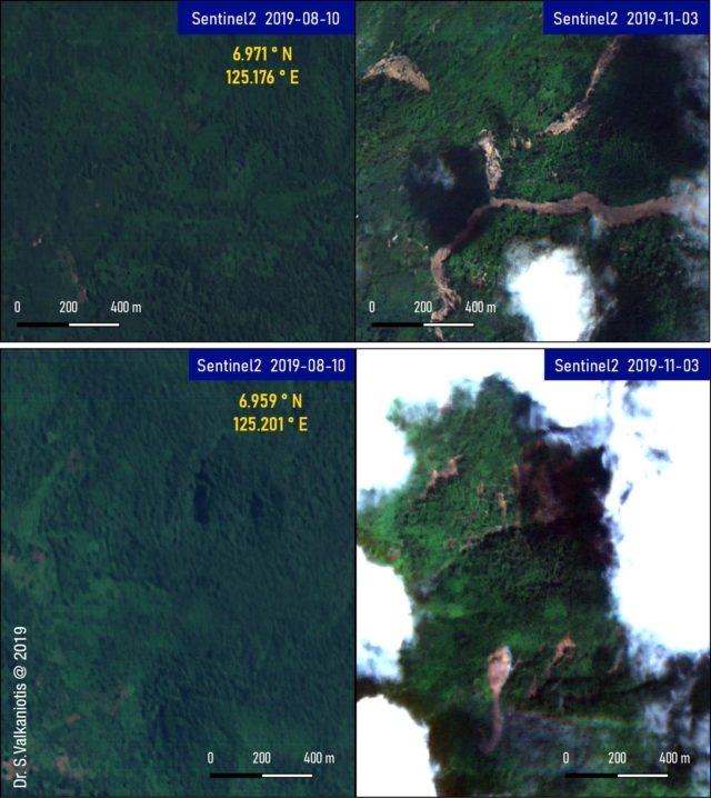
Before and after Sentinel images of the landslides in Cotabato, Philippines. Images from Sentinel 2, tweeted by Sotiris Valkaniotis.
.
The Philippines National Disaster Risk Reduction and Management Council (NDRRMC) is publishing regular Situation Reports on the impact of these earthquakes. SitRep12 (4 November 2019) indicates that the largest landslides were triggered by the 29 October earthquake. To date they have recorded 22 fatalities in total, with five of these being directly attributed to landslides. A further two people are reported to be missing as a result of landslides. However, other fatalities are reported to be the result of “fallen debris”, which could also be the impact of mass movements.
News reports indicate that the impact of landslides could be more a little more substantial. Inquirer reports four people missing in the landslide at Bato and three in Balawan.
 Dave Petley is the Vice-Chancellor of the University of Hull in the United Kingdom. His blog provides commentary and analysis of landslide events occurring worldwide, including the landslides themselves, latest research, and conferences and meetings.
Recent Comments