
11 November 2019
Planet Labs images of landslides triggered by the 2019 Cotabato earthquakes in the Philippines
Posted by Dave Petley
Planet Labs images of landslides triggered by the 2019 Cotabato earthquakes in the Philippines
Planet Labs satellite images have now become available showing at least some of the landslides triggered by the 2019 Cotabato earthquakes sequence in the Philippines, which I highlighted last week. Cloud is still affecting some of the area, so the picture is not yet fully clear, but there is sufficient detail to see at least two large clusters of landslides. Below is an overview image, based on an image collected on 8 November 2019, of one of the clusters (located at 6.960, 125.200). I’ll call this group of landslides the Barangay Buhay cluster; the other cluster I have found is at Barangay Bato (located at 6.84, 125.16). I will endeavour to feature the other later this week.
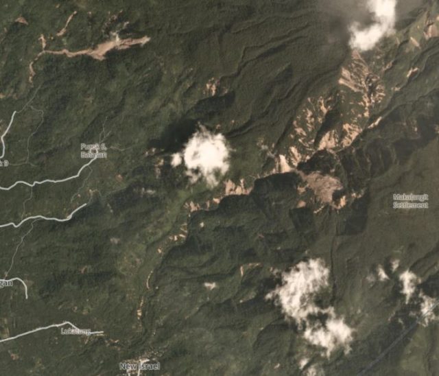
Planet Labs image of the Barangay Buhay cluster of landslides triggered by the Cotabato earthquakes. Planet Labs PlanetScope image, captured on 8 November 2019. Copyright Planet Labs, used with permission.
.
There are two features of note here. One is the c. 1 km long landslide at Barangay Buhay in Makilala, North Cotabato, which is shown in a photograph in an article about survivors of the earthquake, published in Minda News. The article details the survival of an agricultural worker, who was buried up to his neck by one of the landslides, but I think this was probably at Barangay Bato.
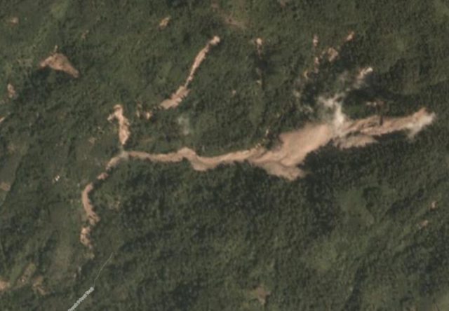
Planet Labs image of one of the largest landslides triggered by the Cotabato earthquakes. Planet Labs PlanetScope image, captured on 8 November 2019. Copyright Planet Labs, used with permission.
.
To the east is a large cluster of landslides, the extent of which is not fully covered by the imagery. This cluster, which extends for at least 5 km from east to west and 3 km from north to south, contains a large number of landslides triggered by the Cotabato earthquakes.:-

Planet Labs image of the Barangay Buhay cluster of landslides triggered by the Cotabato earthquakes. Planet Labs PlanetScope image, captured on 8 November 2019. Copyright Planet Labs, used with permission.
.
The Barangay Bato cluster of landslides, triggered by the Cotabato earthquakes, is also large, so watch this space…
Reference
Planet Team (2019). Planet Application Program Interface: In Space for Life on Earth. San Francisco, CA. https://www.planet.com/
 Dave Petley is the Vice-Chancellor of the University of Hull in the United Kingdom. His blog provides commentary and analysis of landslide events occurring worldwide, including the landslides themselves, latest research, and conferences and meetings.
Perfectamente se puede calcular la cantidad de masa removida y desplaza en la cuenca, asi como el volumen de lluvias, si los hay, por área y los depósitos torrenciales que se forman, mapear esos cuaternarios de una vez.
[Google Translate: You can perfectly calculate the amount of mass removed and displaced in the basin, as well as the volume of rainfall, if any, by area and torrential deposits that are formed, map those quaternaries at once. D.]
Only came across this now while looking for discussions on the Leyte Landslides from earlier today. I happen to live close to one of the landslide clusters. Just to give a bit of a correction/clarification, the large single landslide in the second photo is actually within Barangay Batasan, while the larger cluster of landslides in the first photo is within Barangay Bulatukan. The latter is along the uppermost headwaters of the Bulatukan River, which is a tributary of the Padada River watershed. That river valley has severly steep slopes, and has had previous forest cover loss as well from a forest fire in the late 90s. An aftereffect was that months later all that landslide debris was remobilized into a huge flash flood after heavy rains, and a number of people were killed. The Batasan/Buhay/Bulatukan cluster of landslides are within the Mt. Apo Natural Park.
And yes, the survivor story is probably from the Barangays Bato/Malabuan/Luayon/Bala cluster of landslides, in the Bolacanon Cone Field. In both instances, there are hundreds more smaller landslides that are not visible in both PlanetLabs and Landsat, since they were in near vertical walls and remained obscured by forest cover and heavy vegetation.
As of 2022, the Batasan landslide scar has largely started to stabilize and has shown vegetation regrowth in its lower portions, as with a lot of the Bolacanon Cone Field landslides. The Bulatukan cluster on the other hand lags behind due to the steeper slopes. At the same time as Leyte was being pounded by rains this month, we were experiencing a lot of precipitation as well. The Bulatukan cluster is almost always constantly obscured by cloud, but from my observations via scope over the past 2 days when there are breaks in the cloud, there are clear signs of continued remobilization in the larger landslides.