
29 October 2019
Landslide movement mechanisms: evidence from longitudinal ridges on Mars
Landslide movement mechanisms: evidence from longitudinal ridges on Mars
It is well established that some very rapid rock avalanches develop longitudinal ridge structures. A beautiful example is the Mount La Perouse rock avalanche in Alaska, as shown in the image below:-
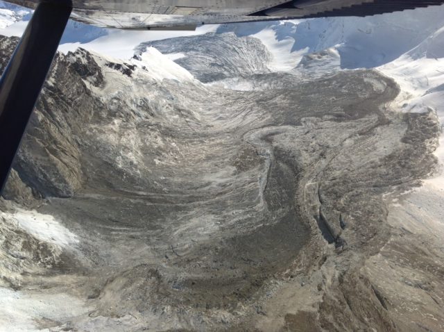
Longitudinal ridges on the Mount La Perouse rock avalanche in Alaska. The ridge structures are clear on the lowest part of the avalanche deposit in the distance. Image by Marten Geertsema.
.
These longitudinal ridges are only seen in very large landslides, and they are present on deposits from mass movements on Earth and on other planetary bodies. Clearly the formation of these structures is indicative of the internal dynamics of the landslide, but their formation has been difficult to understand.
On Earth, such features are most frequently seen in deposits on glaciers. This has led to the proposal that they are associated with flow over low friction surfaces, such as ice or soft (deformable) sediments. The ridges probably form because the avalanche behaves in a manner similar to a fluid, allowing turbulent processes to develop, generating convection cells in the flowing mass. These observations have in turn been applied to the interpretation of large landslides on Mars, for which the presence of longitudinal ridges has been taken to infer that the landslide has flowed over an icy substrate. The apparent presence of this ice clearly has important implications.
However, in a study just published in Nature Communications (and available open access), Magnari et al. (2019) have examined a very large rock avalanche at Coprates Labes, located in Valles Marineris on Mars. This is beautiful landslide deposit – from source to toe it is over 50 kilometres long:-
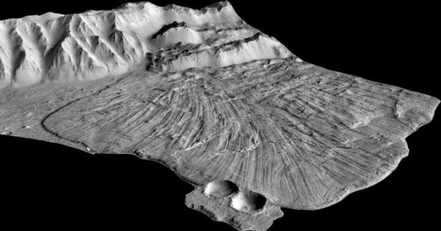
Longitudinal ridges on the vast landslide on Coprates Labes, located in Valles Marineris, Mars. Image via Phys.org, by Magnarini et al. (2019).
.
This landslide clearly displays spectacular longitudinal ridges. Magnari et al. (2019) measured the size and shape of the ridges in this landslide deposit, and have analysed the more subtle morphology of the deposit, most notably en echelon structures superimposed on the ridges themselves, as shown below:-
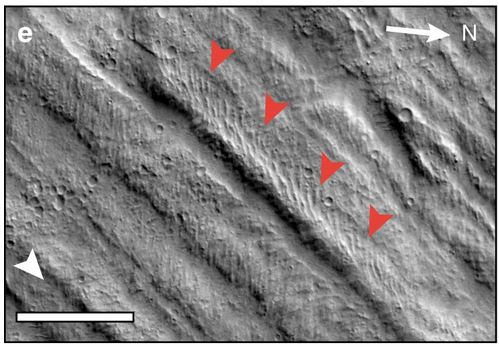
En echelon structures, indicated by the orange arrowheads, superimposed onto the longitudinal ridges on the rock avalanche on Mars. Image from Magnarini et al. (2019).
.
Magnari et al. (2019) note that these more subtle, but clearly evident, features have also been seen in laboratory experiments in rapid granular flows. In the experiments, these features did not require the presence of ice to form. Therefore, they conclude that the presence of longitudinal ridges should not be taken to infer that ice is a prerequisite for the development of these landslides on Mars.
Whilst in many ways the dynamics of landslides on Mars may seem to be a comparatively obscure topic, the analysis of these features casts a light on the mechanisms of landslides on Earth. Most importantly, this study provides further evidence that the movement mechanisms of these giant landslides may be associated with turbulent granular processes in the flowing landslide mass. As these very dynamic landslides become more common in response to global heating, this is an important input to our ability to assess the hazard that they may pose.
Reference
Magnarini, G., Mitchell, T.M., Grindrod, P.M., Goren, L. and Schmitt, H.H. 2019. Longitudinal ridges imparted by high-speed granular flow mechanisms in martian landslides. Nature Communications, 4711 (10). https://doi.org/10.1038/s41467-019-12734-0.
28 October 2019
Gongo Soco: continued deformation of the slope of a high wall mine in Brazil
Gongo Soco: continued deformation of the slope of a high wall mine in Brazil
In the aftermath of the two disastrous tailings dam failures in Brazil, mining company Vale continues to undertake a massive programme of evaluation of the stability of its facilities. According to Mining Magazine, this programme is costing $1.7 billion in the first instance. In early October, the company reported on its progress to date, noting that several facilities continue to cause concern, although they are being actively managed.
One facility that continues to cause concern is at the massive Gongo Soco mine, which is located at -19.957, -43.599. Here, a high wall rock slope on the mine side is actively deforming, raising concerns of a collapse that could displace mine waste, creating another tailings release downstream.
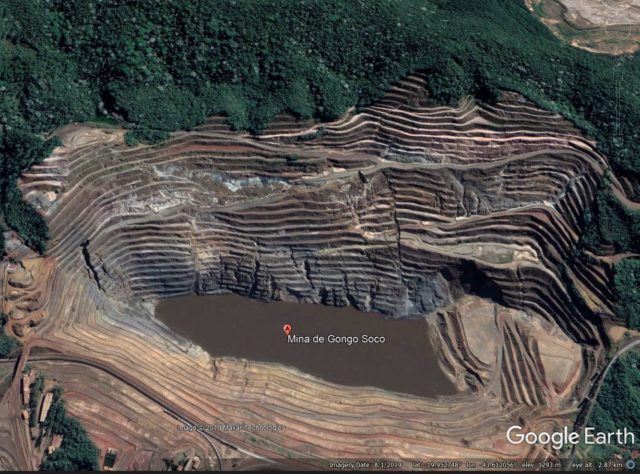
This is a Google Earth image of the site, taken on 1 June 2019:-
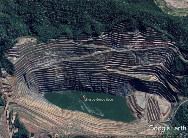
Google Earth image of the Gongo Soco mine. Image dated 1 June 2019.
.
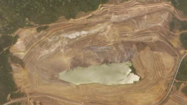
Google Earth has a further image, dated 1 August 2019, which clearly shows the development of this large slope failure:-
Google Earth image of the Gongo Soco mine. Image dated 1 August 2019.
.
Three things stand out here:
- The large fracture that has developed on the right side of the slope, from the fork in the road down to the corner of the lake. I would provisionally interpret this as the lateral margin of the active slide;
- The development of tension features at the back of the deforming block, most notable in the area above the lower track on the centre left of the image;
- General deterioration of the terraces, presumably as the rock mass deforms.
I have take a look at the most recent Planet Labs image of the site. The image below was collected on 18 October 2019 with the PlanetScope instrument. The resolution is lower than the Google Earth imagery, but the continued development of the slope is clear:-
Planet Labs PlanetScope image of the Gongo Soco mine. Image dated 18 October 2019, copyright Planet Labs, used with permission.
.
On the image the lateral scarp on the right side has further developed, and there is now clear evidence of one on the left too. The rear scarp has developed significantly and there is clear evidence of further deterioration of the terraces as well. On the lower part of the slope a set of smaller landslides have developed, with a very notable feature in the central portion.
To manage the risk, the slope is being actively monitored, and a large wall is being constructed downstream to contain any debris in the event of a major collapse.
Reference
Planet Team (2019). Planet Application Program Interface: In Space for Life on Earth. San Francisco, CA. https://www.planet.com/
24 October 2019
The social impact of landslides in Mexico
The social impact of landslides in Mexico
In recent years there has been an increasing number of studies examining the impact of landslides in specific countries, such as China, or in regions of the world, such as Latin America, as well as the global reviews in which I have been involved. These studies have have shone a light on the high level of losses occurring in many areas of the world.
The latest such study (Diaz et al. 2019) examines losses for Mexico over the period from 1935 to 2017. Whilst many other studies have focused directly on losses, this one places an emphasis on the social impact of landslides in Mexico, which is an interesting approach that could be replicated elsewhere. Mexico is particularly in interesting as in the study that I undertook with Sergio Sepulveda on landslides in Latin America (Sepulveda and Petley 2015 – available via open access), Mexico had the 4th largest number of fatalities.
In total, the authors have recorded 1,967 landslides across Mexico, the vast majority of which were triggered by rainfall. The map below shows the geographical distribution of the landslides across the country – note the concentration in the central and southern part of Mexico:-
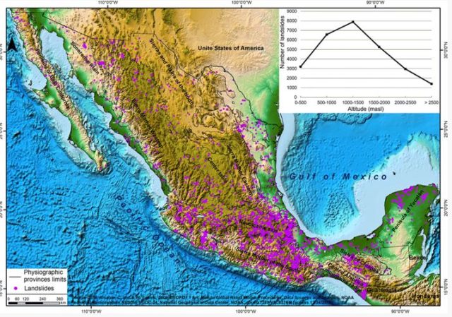
Spatial distribution of landslides in Mexico and altitude in the period from 1935 to 2017. Figure from Diaz et al. (2019).
.
Interestingly, Diaz et al. (2019) ascribe this primarily to the population distribution:
“A higher concentration is noticed in the center of the country; in the states of Hidalgo, Mexico, Puebla, and Tlaxcala; and in the central region of Veracruz along its border with Puebla and northern Mexico City. It is likely that this concentration is related to population density since these are the states with the heaviest infrastructure development in the country.”
Whilst I’m sure this is correct, I wonder whether the climate might be a significant control as well:
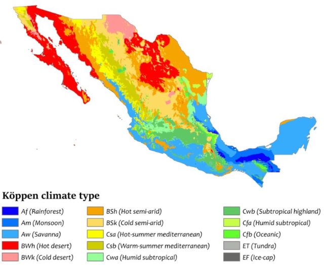
The distrubtion of Koppen Climate types in Mexico. Image via Wikipedia.
.
Diaz et al. (2019) have recorded 3,447 fatalities from landslides over the study period, with the largest event being a catastrophic landslide on 1 October 1956 that claimed 1,000 lives in La Paz, Baja California. The study provides a detailed investigation of the municipalities with the highest number of landslide losses in terms of simple numbers of fatalities and of losses per capita. They examine the degree to which these municipalities suffer from marginalization, defined as “the deficiencies suffered by the population as a result of the lack of access to education, housing in poor condition, low infrastructural development, and lack of material goods.”
Diaz et al. (2019) found that “the concentration of events [i.e. loss causing landslides] occurs in areas with high degrees of marginalization, which indicates that the most marginalized populations are the most prone to experience the effect of any sort of landslide.”
In many ways such a finding is not a surprise, but it is a very useful reminder that landslide losses are a social problem as much as one driven by physical processes.
Reference
Díaz, S.R., Cadena, E., Adame, S. et al. 2019. Landslides in Mexico: their occurrence and social impact since 1935. Landslides. https://doi.org/10.1007/s10346-019-01285-6
Sepúlveda, S.A. and Petley, D.N. 2015. Regional trends and controlling factors of fatal landslides in Latin America and the Caribbean. Natural Hazards and Earth System Sciences, 15, 1821-1833, doi:10.5194/nhess-15-1821-2015. The full paper available to download as a PDF.
23 October 2019
The role of landslide dams in depositing carbon in marine sediments
Catastrophic landslides are an effective way to transport wood from the land to the deep ocean.
The role of landslide dams in depositing carbon in marine sediments
As concern grows about the threats of global heating, there is increased interest in understanding how, when and how much carbon is stored in the oceans. One mechanism is the transport of wood from uprooted trees through the river system and out to sea. This may be a key pathway through which carbon is stored, and thus understanding the mechanisms through which this can occur is important.
In a paper just published in PNAS, (Lee et al. 2019), a team has looked at cores drilled into the Bengal Fan, the largest sedimentary deposit on Earth, which stretches 2,000 km from the mouth of the Ganges River. They have been particularly interested in the presence of wood in these marine deposits. The results are intriguing – the team found very distinct woody layers in the sediments, even in those drilled in 3,700 m water depth, at distances of hundreds of kilometres from land. Perhaps most interestingly, they found one layer, dated to about 50,000 years ago, that contained abundant pristine pieces of conifer, which typically grow at about 3 km above sea level. The implication is that large volumes of wood are able to travel in concentrated pulses from high in the mountains out to the deep ocean. This raises a question as to how this can occur.
Lee et al. (2019) propose that the most likely mechanism is very high discharge events – i.e. catastrophic floods that carry large volumes of woody material in a single pulse. The authors propose that the most likely cause of such floods would be the collapse of either landslide or glacial dams. An article on Eurkalert, informed by one of the researchers, Dr Sarah Feakins (associate professor of Earth sciences at USC Dornsife College of Letters, Arts and Sciences) described how this might happen:
The trees likely were uprooted during the last ice age by a massive release of water from the breach of a natural dam created by a glacier, landslide or similar land feature. In what must have been a surge of water, the trees rode rivers thousands of miles from Nepal through Bangladesh and into the Bengal Fan.
We know that these large, catastrophic events are critically important in creating the landscapes in active mountain chains. The discovery that these extreme events are also important in the ways in which the carbon cycle operates is now becoming clear. Landslides generated by a large earthquake release vast numbers of trees from the hillsides. Very often this wood is then trapped behind landslides dams. The breaching of these dams provides a mechanism through which that wood can transported out to the deep ocean, and buried on the sea floor.
Reference
22 October 2019
Kadavu, Fiji: Planet Labs images of the earthquake triggered landslides on 19 October
Kadavu, Fiji: Planet Labs images of the earthquake triggered landslides on 19 October
On 19 October 2019 a M=5.7 earthquake struck the island of Kadavu in Fiji. Whilst not a large event, it was sufficient to give the volcano of Nabukelevu (also known as Mount Washington) a decent shake, triggering rockslides. These landslides were captured on a very high-quality video taken from the sea, which shows multiple events. The dry volcanic rocks generate a large amount of dust, which accentuates the effects. The video is on Youtube:-
On Twitter, Sotiris Valkoniotis (@SotisValkan) noted that these landslides are visible on Sentinel imagery captured later the same day. So, I have taken a look at the Planet Labs imagery of the area. Planet Labs captured a decent image of the site on 20 October 2019, which shows the scars of the landslides:
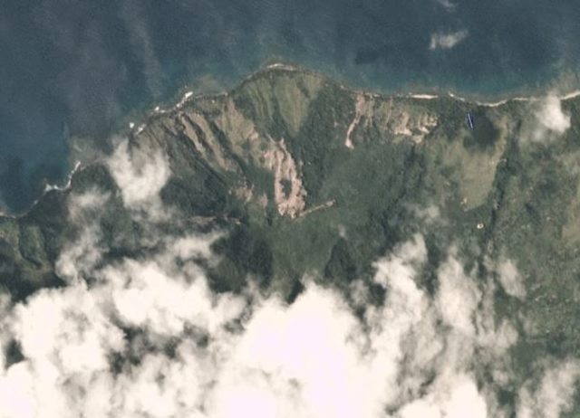
Kadavu landslides as captured in a PlanetScope image, dated 20 October 2019. Copyright Planet Labs, used with permission.
By comparison, this is the same site imaged on 23 September (with less cloud):
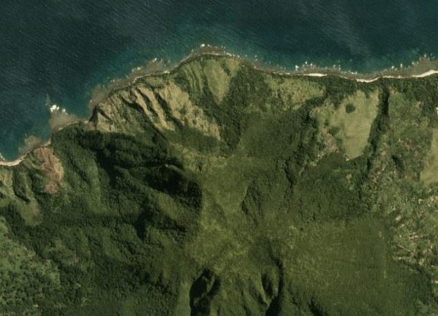
The site of the Kadavu landslides as captured in a PlanetScope image, dated 23 September 2019. Copyright Planet Labs, used with permission.
In the aftermath of the earthquake, the Fiji National Disaster Management Office has issued a warning to remain clear of the landslide sites and to avoid diving in the vicinity of the Nabukelevu volcano:
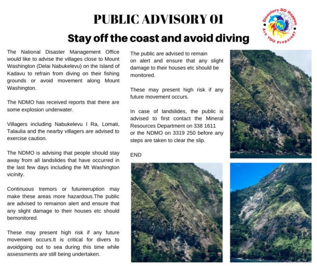
A warning from The Fiji National Disaster Management Office about landslides on Kadavu.
In the short-term, the Mineral Resources Department will be undertaking assessments of the landslides triggered on the mountain in the aftermath of the earthquake.
This is not the first time that Kadavu has suffered landslides – for example, in May 2018 the Fiji Roads Authority published some images of a small landslide that affected a road on the flanks of the volcano.
Reference
Planet Team (2019). Planet Application Program Interface: In Space for Life on Earth. San Francisco, CA. https://www.planet.com/
21 October 2019
Shchetinkino: a major dam collapse at a gold mine in Siberia
Shchetinkino: a major dam collapse at a gold mine in Siberia
On Saturday 19 October 2019 a dam collapsed at a gold mine near to Shchetinkino in Siberia. To date 15 fatalities have been reported, whilst five people remain missing. This is of course just the latest in a long series of mine related dam failures, a topic upon which I have written regularly.
Reports suggest that the dam was impounding water rather than tailings on this occasion. The structure was reported to have been illegal, with a height of about 5 metres. Some reports suggest that three people have been arrested over the incident.
A report on Yahoo News suggests that the event occurred as a cascade of five dam failures. The released water struck workers accommodation below the lowest dam, killing employees from the mine. This image shows the aftermath:-
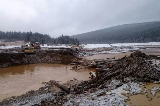
The aftermath of the dam collapse at Shchetinkino in Siberia on 19 October 2019. Image via Yahoo News and AFP.
.
I have taken a quick look at the Planet Labs imagery of the area. Bad weather means that no images are yet available of the aftermath of the event, but this image shows a large area of mining upstream from Shchetinkino, collected on 15 October 2019. Note the multiple, haphazard water storage area, and the various piles of mine waste, through the valley.
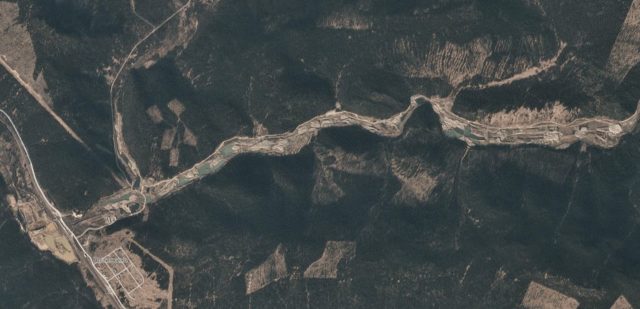
The site of the Shchetinkino dam collapse. Planet Labs PlanetScope image, collected 15 October 2019. Image copyright Planet Labs, used with permission.
.
Hopefully the weather will clear in the next few days, meaning that post-collapse imagery will become available. The local authorities have indicated that they were not aware of the construction of the dams, but as the images above show, they are easy to detect.
At present the amount of downstream damage is not clear.
Reference
Planet Team (2019). Planet Application Program Interface: In Space for Life on Earth. San Francisco, CA. https://www.planet.com/
18 October 2019
The landslide impact of Typhoon Hagibis in Japan
The landslide impact of Typhoon Hagibis in Japan
The landslide impact of Typhoon Hagibis in Japan is slowly becoming apparent. For example, the Japan Times has a nice article about landslides along the route of the 2020 Olympic cycling road race. This area has suffered sever landslide impacts. The article has a good Youtube video with some very nice images of the landslides and their impacts upon the road:-
.
I would imagine that the road will be repaired ahead of the Olympics, although this is uncertain at present. It is of course worth noting though that the Olympic Games will be held in the typhoon season.
Meanwhile, The Mainichi has an article about a mountain railway in Hakone, Kanagawa Prefecture that has also been severely damaged by landslides:-
This image, from the same article, shows some of the damage:-
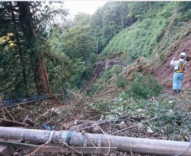
Landslide damage from typhoon Hagibis. Image via The Mainichi.
.
Note the state of the track in the centre of the image – it has been left hanging in the air.
The Mainichi also has an analysis of the 77 people who died in Typhoon Hagibis. They understood the circumstances of 64 of the fatalities, finding that of these 27 died at home and 17 on the road as a result of flooding and landslides. Ten of the people who died at home lost their lives in landslides. As is usual in Japan, the majority of the people who died in their homes were aged over 60.
Evacuating elderly populations at risk is challenging in any environment. Rural areas in Japan often have a very high proportion of older people, meaning that the problem is particularly challenging there.
16 October 2019
Landslide risk management in Rio de Janeiro
Landslide risk management in Rio de Janeiro
Rio de Janeiro in Brazil is a city with significant levels of landslide risk. In April 2010, heavy rainfall triggered a large number of landslides across the city, killing hundreds of people. For example, Nova Friburgo suffered multiple landslide events with catastrophic outcomes:-
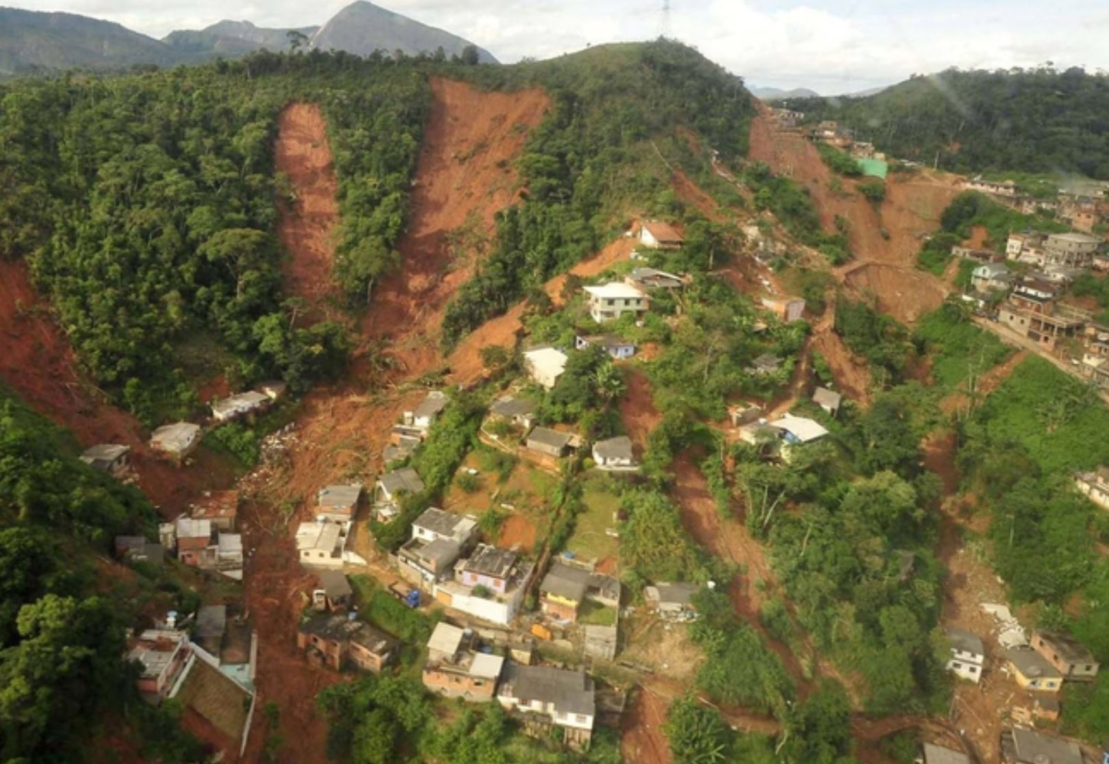
Landslides from 2010 in the Rio de Janeiro area of Brazil. Image via RTE.
.
As a result of repeated landslide disasters, Rio de Janeiro has instigated a landslide risk management programme that is impressive in its ambition and scope. Rio On Watch has published a good, detailed article, by Abby Hanna, that provides a review of this work. This provides links to a number of resources that underpin the landslide risk management work, including an excellent presentation that includes information about historic landslide events in the city.
The article provides detail about the five steps that have been taken to manage landslide risk in Rio de Janeiro:-
- Knowledge: Includes a mapping of all risk areas in the city (last completed in 2011) and slope susceptibility (using thematic maps, aerial photos, and lasers).
- Prevention: Includes the creation of Alerta-Rio (telemetric rain gauge network that began in 1996), the addition of a meteorological Doppler radar in 1999, emergency shelter points, community leader training, Rio’s Center of Operations (COR), and audible alert/alarm levels added in 2011.
- Diagnostics: Includes the development of mitigation projects in 117 communities designated as high-risk and the division of 112 communities into 10 regional sections.
- Intervention: Refers to methods and protocol for slope containment constructions, with a reported budget of R$83 million (US$21 million) for 2001-2008 and R$320 million (US$80 million) for 2009-2012.
- Monitoring: Drones, barometers, rain gauges, tracking with GPS, meteorological/weather stations with audio and video in real-time.
Underpinning the system is the “Community-Based Alert and Alarm System,” which provides a warning of heavy rainfall and, in the most vulnerable locations, triggers sirens to warn residents that landslides are possible.
Such systems are never perfect. Earlier this year, Rio de Janeiro suffered 17 fatalities as a result of heavy rainfall. But, these types of programmes certainly have their place in reducing landslide risk, and deserve further investment.
15 October 2019
2020 International Summer School on Rockslides and Related Phenomena in the Kokomeren River Valley (Kyrgyzstan)
International Summer School on Rockslides and Related Phenomena in the Kokomeren River Valley
2020 International Summer School on Rockslides and Related Phenomena in the Kokomeren River Valley (Kyrgyzstan) (ICL Kokomeren Summer School)
Rockslides and rock avalanches are among the most hazardous natural phenomena in mountainous regions. Though relatively rare, in comparison with landslides in non-lithified soils, they threaten large areas due to the enormous amount of material involved (sometimes up to billions of cubic meters), high mobility of debris and ability to create large natural dams, which result in inundation of the valleys upstream and catastrophic outburst floods downstream. The aim of the International Summer School is to demonstrate rockslides of the planar, rotational, wedge and compound types, most of which had converted into flow-like rock avalanches, sometimes with the extremely long-runout. Some of these slope failures formed natural dams, either intact or deeply eroded. Various methods of their identification, mapping, dating, as well as of the detailed examination and analysis of internal structures and grain-size composition of rockslide deposits are demonstrated.
About 20 rockslides and rock avalanches ranging from a few millions to more than 1 billion cubic meters in volume are concentrated in the Kokomeren River valley (Central Tien Shan) within a limited area of about 100×50 km at a one-day trip distance from Bishkek – capital city of Kyrgyzstan. Most sites are located near a road along the Kokomeren River and require several hours driving and few kilometers long hiking with up to 300-500 m rise to reach them.
Due to the arid climate and sparse vegetation, rockslide morphologies are well preserved and recognizable. Some rockslide deposits up to 400-m thick are deeply dissected by erosion which opens their internal structure to detailed study. Evidence of valley inundation caused by rockslide damming and of associated outburst floods could be found in the valley as well. Along with the bedrock slope failures several very large landslides in weakly lithified Neogene and Quaternary deposits can be found in the adjacent neotectonic depressions. Besides providing an exceptional learning experience, it is a very beautiful mountainous area inhabited with kind and hospitable people.
Besides numerous rockslides and landslides, the study area provides impressive manifestations of the Neotectonics and Quaternary tectonics such as active faults, one of which was ruptured during the 1992 M7.3 Suusamyr earthquake, and numerous examples of tilted and folded pre-Neogene planation surfaces. One of the topics of the training course is the paleoseismological interpretation of large rockslides and rock avalanches.
The 2020 ICL Kokomeren Summer School will be held out from 1st to 15th August 2020. The participation fee is EURO 500 (or equivalent amount in US dollars, Russian roubles or Chinese yuan), which includes all costs at the site: camping (in tents; though some tents can be provided by the organizers, participants are asked to bring their own tents and sleeping bags), food, local transportation, detailed full-color guidebook. Electricity will be available in the base camp. Fee should be paid in cash at the participants’ arrival. Cash receipt vouchers and certificates confirming attendance at the ICL field training course will be provided.
Organizers will provide help obtaining visas if necessary. Please check if you need visa to come to Kyrgyzstan or not. List of countries which citizens do not need visas to visit Kyrgyzstan is available at http://www.centralasia-travel.com/en/countries/kirgistan/visas. Those who have to apply for visa should send the copy of his/her passport to Prof. Kanatbek Abdrakhmatov before June 1st, 2020. Participants should have personal medical insurance.
Participants should arrive to Bishkek not later than the early morning of 1st August. They will be picked up at the arrival desk of the Bishkek airport. Bishkek is connected with Moscow, Istanbul, Urumchi, Dubai, Ulan-Bator and Delhi by direct flights. Arrival via Almaty airport is possible as well. Organizers can help arranging the hotel/hostel for the participants who will arrive earlier than 1st August or will depart after 15th August. The cost of the hotel/hostel in Bishkek selected by organizers for one night from 14th to 15th August is included in the registration fee.
The detailed full-color ICL Kokomeren Summer School guidebook can be downloaded from the ICL homepage: http://iplhq.org/ (Download GUIDEBOOK).
Those who are interested, please contact:
Dr. Alexander Strom,
Chief expert of the Geodynamics Research Centre,
Volokolamskoe Shosse, 2, 125080, Moscow, Russia
e-mail: [email protected]
tel: +7 910 4553405
Or
Prof. Kanatbek Abdrakhmatov
Director of Institute of Seismology, National
Academy of Science,
Asanbay 52/1, Bishkek 720060, Kyrgyzstan
e-mail: [email protected]
tel: +996 777 403480
9 October 2019
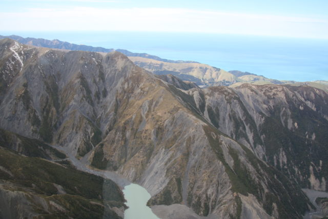
Whanganui: a large landslide on State Highway 4 in New Zealand
Whanganui: a large landslide on State Highway 4 in New Zealand
Late last week a large landslide developed on State Highway 4 between Whanganui and Raetihi in Ruapehu district of New Zealand. The landslide, which reportedly has been developing for some time, has destroyed the road, causing considerable local disruption. A local photographer, Mark Brimblecombe, collected a series of images of the landslide via a drone at the weekend. These stunning images capture the size and scale of the failure beautifully.
This image is a good view of the scale of the landslide and the level of damage that it has caused:-
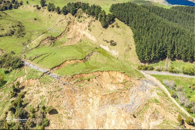
The full scale of the landslide near Whanganui in New Zealand. Image captured by Mark Brimblecombe, posted to Facebook.
.
Meanwhile this image shows a different view of the extent of the landslide:-
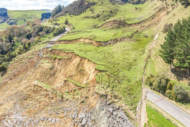
A panoramic view of the landslide near Whanganui in New Zealand. Image captured by Mark Brimblecombe, posted to Facebook.
.
Note the total destruction of the section of road and also the extent of the tension cracks up the slope (see below), especially on the left hand side. Also worth noting is the landscape in the distance on the far left side – this shows the distinctive features of a potential ancient, now inactive landslide.
I noted above the full extent of the tension cracks extending up the slope. This image, also captured by Mark, shows this in more detail:-
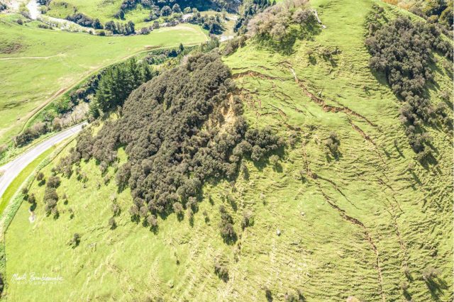
Tension cracks towards the rear of the landslide near Whanganui in New Zealand. Image captured by Mark Brimblecombe, posted to Facebook.
.
These image suggest that there is a significant volume of material still to be released in this landslide. Reconstructing the road is going to be a very substantial challenge given the magnitude of the landslide, and the volume of partially failure material. To give an idea of the scale of the disruption, RNZ reports that:
“For local logging truck company, McCarthy Transport, the detour was adding an extra 130 to 200 kilometres to their trip, the company’s chief executive Steve McDougall said.”
Acknowledgements
Many thanks to those people who highlighted this to me. My blog really depends on the community effort in which people highlight such events, so your help is really appreciated. Thanks also to Mark Brimblecombe for both collecting the images and for sharing them so openly. They are magnificent.
 Dave Petley is the Vice-Chancellor of the University of Hull in the United Kingdom. His blog provides commentary and analysis of landslide events occurring worldwide, including the landslides themselves, latest research, and conferences and meetings.
Recent Comments