
5 October 2010
Tailings landslide in Hungary and a dam crisis in Vietnam
News today, barely covered in the international mainstream media so far, of a new tailings-related landslide in Hungary yesterday. The only English report that I have seen so far is on the Chinese CriEnglish website, which reports that 700,000 cubic metres of bauxite ore formed a flow that struck three villages in Veszprem county. These villages appear to be Devecser, Somlóvásárhely and Kolontar.
The Google Earth imagery of this area shows the origin if the accident rather clearly as the red bauxite ore in the lagoon is fairly obvious. This location is confirmed by an article on NOL.
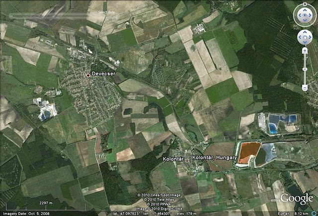
Interestingly, a slightly older Google Earth image is also available (this is from March 2008, whereas the one above is from October that year). This image appears to show a rather less full lagoon:

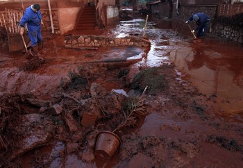
Reading Hungarian news reports is not my strong point, but MNO has a detailed article on the event. This suggests that three people have been killed and 113 injured, of which 73 people required hospital treatment. Unfortunately, bauxite ore was is a very nasty material, causing alkali burns, so some of the injuries could be very serious. The residue of the disaster is pretty foul as the MNO article illustrates:
I haven’t yet seen any images of the embankment failure that caused this event – I expect that these will appear online today. I will post again when these are available.
Meanwhile, in Vietnam there are reports of a rather different crisis. Vietnam Net Bridge reports that 20,000 people have been evacuated from below the Ho Ho Dam in Huong Khe district of Ha Tinh province. The reports suggest that during the ongoing heavy rainfall the spillway door jammed closed, causing the lake to overtop the dam. Although the door has now been fixed, concerns remain that the dam may collapse.
3 October 2010
Continued debris flow activity in the Wenchuan (Sichuan) earthquake area
A frequently-forgotten but potentially very damaging impact of large earthquakes in mountain areas is the increased occurrence of debris flows and other landslides in the following years. Whilst these events continue to represent a hazard in their own right, they frequently also cause changes to river dynamics, with resultant high levels of damage. This problem was illustrated all too clearly in a small village that we visited close to Beichuan last week. For those who would like to locate the village. my iPhone GPS said that we were at 32.13N, 105.54E. This small, remote village of about 200 people lost about 20 residents in the earthquake itself. However, the real impact has come in the aftermath. This small factory was main source of employment in the area. It survived the earthquake but has been destroyed by repeated debris flows that have occurred every summer since the earthquake:

If you look carefully you can see the brown mud stains and splatters up the wall that show the height of the flood at its height. The river bed is continuing to aggrade (increase in elevation due to sediment accumulation) at this point, slowly burying the ruins.
Upstream the village itself shows clear signs of the damage to houses and other structures from the earthquake shaking:

In some cases repairs to the buildings had started before the debris flow activity started:

However, the ongoing landslide activity, and resultant changes to the riverbed, are proving to be devastating, with high levels of hazard and repeated burial of buildings:


The effect is to hugely reduce the rate at which reconstruction can occur, and to greatly increase poverty as the the people have lost both their assets and their most productive farmland. As a result, two years on they are still living in the emergency huts constructed after the earthquake, which are now becoming fossilised into permanent structures, albeit of a poor quality:

Unfortunately, these problems are likely to persevere long into the future, leaving the population with serious challenges for decades to come. Unfortunately, a key impact is likely to be to drive the young into urban areas, leaving rural areas populated by elderly people living in a state of great poverty.
2 October 2010
Beichuan town – the old and the new
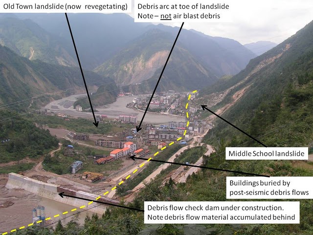
On Wednesday I was fortunate to be able to return to Beichuan (see my images of the town, taken last year), the heart of the earthquake-affected areas in Sichuan. Well, to be more accurate I visited the viewpoint looking down on the town. It is clear that debris flows continue to be a major problem at this site:

For those who don’t know the site I have annotated the image below to point out the key features:
Meanwhile, about 25 km away on the plain the new town of Beichuan, replacing the settlement above, which will be preserved as seen, is almost complete. We called in on the way through – it is an astonishing place. This has been constructed at a cost of 15 billion Yuan (US$2 billion), of which just under 10 billion Yuan has been spent to date. It will ultimately be the home of 70,000 people, and the administrative headquarters of Beichuan County. These images show the new town in the week of hand-over. First an aspiration as to what it should look like, according to a billboard at the site. Note the western brands (Calvin Klein, McDonald’s):

Somehow these image feels a little sad. Here is the reality of one of the many residential areas:

And here is one of the streets, which have been built with cycle lanes:

Pleasingly, there is a very strong attempt to retain a strong traditional sense to the architecture of the central parts of the town, as shown by this bridge across the river:

I hope this is a huge success – the people of Beichuan deserve it.
26 September 2010
Images of yesterday's landslide-induced train incidents
First, an apology in advance. I am just en route to Chengdu in China, where I will stay until Saturday. Whilst this provides an opportunity to return to Beichuan, which will be very interesting in the context of the rainfall-induced landslides this summer, it presents some other challenges. The most serious of these is that Blogger is blocked by the Great Firewall of China, so I will not be able to access it to make posts. So if it all goes quiet for the next few days, please accept my apologies. I should be able to post again on Saturday.
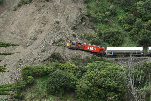
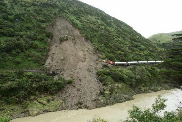
Anyway, in the meantime thanks to various people for highlighting photos of the various landslide-related train incidents over the last 48 hours. It now appears that New Zealand on its own experienced two incidents; in addition to the one at Manawatu Gorge there was also an incident at Taumaranui. There were no injuries in either case.
In terms of the Manawatu Gorge incident, stuff.co.nz has a pretty spectacular set of images:
Meanwhile, there are also some images of the incident in India available on The Hindu website here. Unfortunately, at the time of writing their site is down, but I managed to access it last night. Hopefully you will have more luck!
Images of yesterday’s landslide-induced train incidents
First, an apology in advance. I am just en route to Chengdu in China, where I will stay until Saturday. Whilst this provides an opportunity to return to Beichuan, which will be very interesting in the context of the rainfall-induced landslides this summer, it presents some other challenges. The most serious of these is that Blogger is blocked by the Great Firewall of China, so I will not be able to access it to make posts. So if it all goes quiet for the next few days, please accept my apologies. I should be able to post again on Saturday.
Anyway, in the meantime thanks to various people for highlighting photos of the various landslide-related train incidents over the last 48 hours. It now appears that New Zealand on its own experienced two incidents; in addition to the one at Manawatu Gorge there was also an incident at Taumaranui. There were no injuries in either case.
In terms of the Manawatu Gorge incident, stuff.co.nz has a pretty spectacular set of images:
Meanwhile, there are also some images of the incident in India available on The Hindu website here. Unfortunately, at the time of writing their site is down, but I managed to access it last night. Hopefully you will have more luck!
25 September 2010
Three landslide-induced railway incidents in a single day
News today of three different incidents from around the world:
1. New Zealand
NZ Herald reports that a milk train hit a landslide in Manawatu Gorge. Fortunately there were no injuries, or even a need to cry over spilt milk…
2. India
Bangalore Mirror reports that three coaches of the Thiruvananthapuram-Mangalore Express train were buried by a landslide in a narrow cutting at Mulunthurthy. Three people were injured, plus there were some minor injuries during the evacuation.
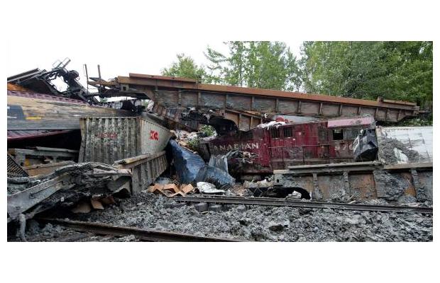
3. Canada
Various Canadian newspapers report that there was a serious landslide-induced derailment of a freight train at St-Lazare in western Quebec. The accident trapped the injured train crew in their cab, requiring that they were rescued by firefighters. Heavy rainfall was reported to be the trigger. The images of the site, from the Montreal Gazette, are impressive:

Landslides represent an important risk to railways in upland areas, and where extensive earthworks have been used. Railway companies expend huge amounts of resource mitigating the threat, usually with success. Incidents are quite rare, but previous examples described on this site include:
May 2010: 19 killed when a train struck a landslide in China;
April 2010: Nine people killed when a train was struck by a landslide in northern Italy;
July 2009: Four people killed when a train struck a landslide from a cutting in China;
Dec 2008: A train was struck by a flowslide formed from power station ash in Tennessee, USA;
24 September 2010
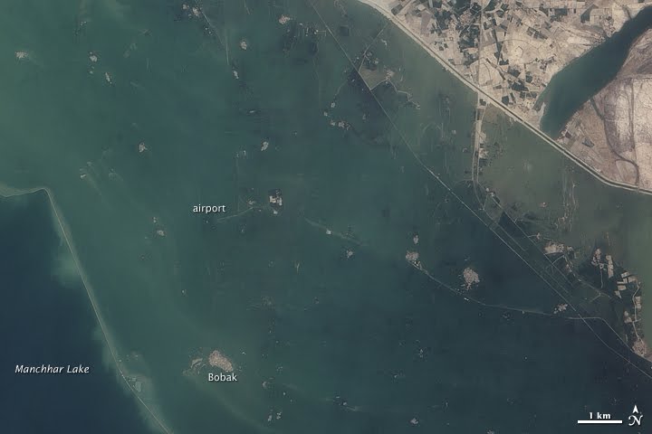
Remarkable NASA imagery of catastrophic flooding around Manchhar Lake in Pakistan
NASA have provided the most dramatic evidence yet of the catastrophic floods that are occurring around Manchhar (Manchar) Lake in Pakistan (see my post yesterday on this issue). This image was captured by the ALI instrument on 18th September:
Compare this with an image taken of the same area just three days earlier:

Or the Google Earth image of the same area, which was collected in May this year:

Geo-TV, an independent TV station in Pakistan, reports that some of the breaches that are causing these floods are now 1 km wide, whilst NTDTV notes that the number of people displaced by this most recent component of the floods may be as high as 250,000.
The breaches have allowed the water level in the main body of the lake to fall slightly, bringing some relief elsewhere, but with new areas continuing to experience flooding that is not cause for much overall cheer.
21 September 2010
Tangjiashan again – and a possible new Chinese flowslide
Back in 2008 I dedicated a great deal of space on this blog to the extraordinary efforts by the Chinese Army to draining the landslide lake at Tangjiashan, just above the town of Beichuan, which was created by the May 2008 Wenchuan Earthquake.

These efforts were ultimately successful, but in my visit to the site in Spring 2009 it was clear that a threat remained at the site in the form of another block of material that was showing signs of deformation. Over the last few days this area has received very high levels of rainfall. Yesterday, Xinhua reported that a 300,000 cubic metre block has detached from the scarp above the barrier, and blocked the river to a depth of 10 metres:
China is well-versed in dealing with these hazards, but given the magnitude of the destruction in the Beichuan area, such events must cause great heart-ache.
It is clear that the elevated level of landslide activity in the aftermath of the landslide is a major issue. I am travelling to Chengdu on Sunday, so will see whether I can ascertain more information about these issues.
Meanwhile, Bloomberg reports a probable flowslide failure in a tin mine in Guangdong yesterday:
China has been impacted by a series of these events in recent years, including one that caused multiple fatalities in 2008. There appears to be a strong need to improve the safety of these facilities before another major accident occurs.
Gifts and Perils of Landslides
Ken Hewitt has written a wonderful article for Scientific American entitled “Gifts and Perils of Landslides”, in which he examines the inter-relationship between the development of society and the occurrence of landslides in the Upper Indus valleys. Ken is the guru of high mountain landslides in Pakistan, having spent many field seasons mapping rock avalanche deposits in the remote upper valleys of the Hindu Kush. The article is available online at the following link:
http://www.americanscientist.org/issues/feature/2010/5/gifts-and-perils-of-landslides
His key point is that these giant landslides create both destruction and benefits to humans in this very rugged topography, the latter because they create terrain that is fertile (e.g. on lake beds formed behind landslide dams) and less steep.
The piece will be accompanied in due course by a slideshow, which will be online here. This is not yet available.
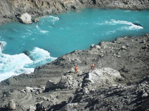
Meanwhile, the Pamir Times has an image of restarted works on the Attabad landslide, the aim of which is to widen and then, I understand, to deepen the spillway:
20 September 2010
Landslides in Art Part 7 – Jennifer Williams
Regular readers will know that I occasionally highlight a piece of art featuring landslides. This is usually a piece of visual art (such as this and this), but occasionally it is a song or even an installation. This time I thought I’d feature a piece of art by the American artist Jennifer Williams, who paints environmentally-orientated pieces using acrylic on birch panels. Jennifer works mostly in the Pacific Northwest, where both the landscape and the sky is large and colourful. This is reflected in her portfolio of work, which resonates strongly through its depictions of the landscape of hazards.
I’d like to highlight here two pieces. First there is a painting called lahar, created as part of a portfolio encompassing the natural regeneration of the Mount St Helens area:
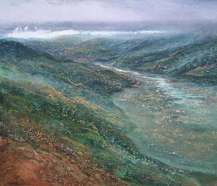
Second, and for me more strikingly, is a piece entitled simply “Landslide”, painted in 2008, and visible through the Waterworks Gallery website:

To me this captures the chaos and ruin of the catastrophic earthflows we see in the Himalayas and other high mountain environments during heavy rainfall. Amazing stuff.
 Dave Petley is the Vice-Chancellor of the University of Hull in the United Kingdom. His blog provides commentary and analysis of landslide events occurring worldwide, including the landslides themselves, latest research, and conferences and meetings.
Recent Comments