
24 September 2010
Remarkable NASA imagery of catastrophic flooding around Manchhar Lake in Pakistan
Posted by Dave Petley
NASA have provided the most dramatic evidence yet of the catastrophic floods that are occurring around Manchhar (Manchar) Lake in Pakistan (see my post yesterday on this issue). This image was captured by the ALI instrument on 18th September:
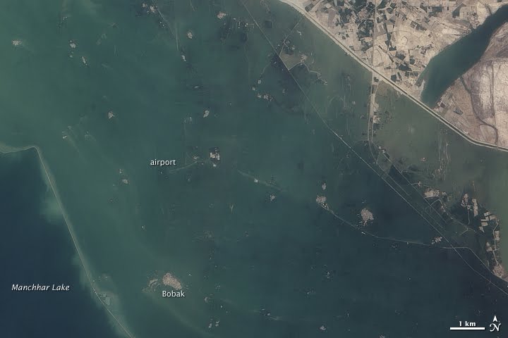
Compare this with an image taken of the same area just three days earlier:

Or the Google Earth image of the same area, which was collected in May this year:

Geo-TV, an independent TV station in Pakistan, reports that some of the breaches that are causing these floods are now 1 km wide, whilst NTDTV notes that the number of people displaced by this most recent component of the floods may be as high as 250,000.
The breaches have allowed the water level in the main body of the lake to fall slightly, bringing some relief elsewhere, but with new areas continuing to experience flooding that is not cause for much overall cheer.
 Dave Petley is the Vice-Chancellor of the University of Hull in the United Kingdom. His blog provides commentary and analysis of landslide events occurring worldwide, including the landslides themselves, latest research, and conferences and meetings.
http://www.reliefweb.int/rw/fullmaps_sa.nsf/luFullMap/2182E0180CE51CDB852577A700522215/$File/map.pdf?OpenElementPakistan Floods: Manchar Lake Area – Satellite Detected Water as of 22nd September 2010.Images by Italian Space Agency (ASI)
[…] most of us the Pakistan floods feel like something that happened a while ago, lost in the mists of the summer (or winter if you […]