
14 October 2010
Some statistics on disasters worldwide
Yesterday was the annual United Nations International Day for Disaster Reduction, which this year had a strong urban theme. To highlight the event, which has been somewhat overshadowed by the extraordinary rescue of the Chilean miners, UNISDR put out a press release highlighting the costs of disasters worldwide. The statistics are somewhat sobering:
- So far in 2010 more than 236,000 people have been killed in disasters
- 256 million people have been affected by disaster events, mostly in urban areas
- The cost of disasters in the first nine months of this year is US$81 billion. Most losses are uninsured
With regard to the vulnerability of urban areas:
- More than a billion people live in urban slums
- An estimated 3,351 cities are situated in coastal zones that are potentially vulnerable to sea level rise
- Six of the ten largest cities are in seismically active areas
To mark the day, Xinhua released statistics on disaster impacts in China this year to date:
- Floods, landslides and mudslides have killed 3,313 people so far this year
- 15.7 million people have had to relocate
- Economic losses are estimated to be a staggering US$55.4 billion
13 October 2010
Important news about this blog
As Dave’s landslide blog approaches it’s third anniversary, I have some important news about the future of the site. As you are aware, the blog currently sits on blogger, which is a commercial blog site owned by google. Whilst it has served the purpose well, I would rather it was located on a proper science-led site. A few months ago I was approached by the AGU, the world’s largest earth science organisation, with an offer to host the blog. After discussions I have accepted this great suggestion, so the blog will move,, hopefully in the next couple of weeks, to the new site. The plan is that this blog will be one of a collection of seven or so geoblogs on the AGU blog site. I will provide details of the new site, and of the other blogs that are moving there, in the next few days.
The move will cause some disruption, but I hope this can be minimised. My plan is to run the new site and the original site in parallel for a few weeks. Otherwise there will be no major changes to the site – I will retain full editorial control of the blog.
12 October 2010
Slope Stability 2011
The website of the latest in an excellent set of Canadian conferences on slope stability and instability is now available at the following link:
http://www.slopestability2011.ca/
The meeting will be held on 18th-21st September 2011 in Vancouver. The focus is on Rock Slope Stability in Open Pit Mining and Civil Engineering. The call for papers is now out, with abstracts due by 31st December 2010.
This meeting serves as a nice aperitif to the International Symposium on Landslides, which will be held in Banff, Canada in June 2012. Abstracts for that meeting are due on 15th April 2011.
11 October 2010
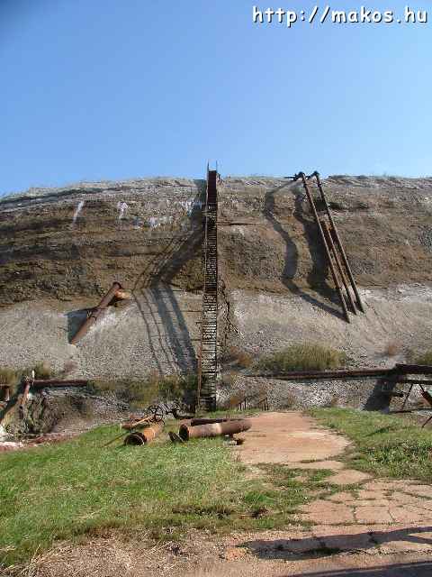
Images of the top surface of the Ajkai Timfoldgyar / Kolontar tailings dam
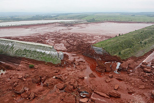
The index.hu website has a set of images taken of the top of the dam at Ajkai Timfoldgyar / Kolontar. These are helpful in confirming observations from the aerial imagery featured yesterday that a section of the tailings dam has moved. This images shows the pipe running across the top surface of the dam:

As expected, the image shows that the main block shown has moved to the right and subsided. However, it is less clear to me as to whether at the remainder of the dam to the breach has actually moved. However, newspaper reports suggest that this wall is now considered to be so unstable that it is likely to collapse. Attempts are underway to build a bund to contain the resultant spill.
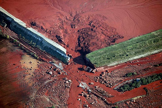
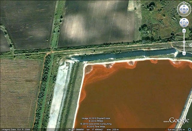
Meanwhile, there is now some post-event Google Earth imagery available for download here. Whilst the resolution is not really good enough to see exactly what has happened at the dam itself, it rather clearly shows the flowpath of the debris:

10 October 2010
Further insights into the failure mode of the Ajkai Timfoldgyar (Kolontar) tailings dam
Thanks once again to Peter Diehl, the causes of failure of the Ajkai Timfoldgyar / Kolontar tailings dam are becoming clearer, and appear to support initial suspicions. There is an excellent gallery of images here, of which this is the most interesting in this context:
This is the damaged (cracked) section of the north side of the dam. Zooming into the cracks on the top of the dam shows this:
The pipeline running across the top of the dam is clear. Note that where it crosses the main (left side) crack the pipeline has been detached from the supports, which have moved forwards and downwards. A little further to the right the pipe has ruptured, and tailings have spilt across the dam surface. Thus, it is clear that the dam has moved forward and subsided at this location, which further supports (though does not confirm) the suggestion that the dam collapse was associated with failure of its foundations.
Interestingly, some suggestions are also emerging that this section of the dam had been leaking ahead of the collapse. WWF has an aerial image taken in June this June of the dam that appears to show a small leak:

However, this should be treated with some caution as there may be other explanations for this apparent spill of tailings on the downstream side of the dam. Finally, there is a gallery of image here that shows the state of the dam in 2005. These two give a pretty good idea of the general state of affairs at the dam:
Comments?
9 October 2010
New aerial images of the Ajkai Timfoldgyar tailings dam site
Thanks again for Peter Diehl for his help with this one. Greenpeace have collected and released some oblique aerial images of the site at Ajkai Timfoldgyar (Kolontar) that are revealing. They are available on the Der Standard website. The best image of the dam itself is this one:
Note the crack in the dam surface on the left side of the image. It is also worth noting that the dam structure on the left side of the breach is rather different from that on the right. Finally, note the interesting shape of the fracture on the left side of the breach. I continue to be interested in the foundation of this structure, although I would also be interested to know a little more about the transition between the dam structure on the left side and that on the right side of the breach.
Meanwhile, Peter has also tracked down the aerial video imagery of the breach. This can be accessed here.
8 October 2010
September 2010 fatal landslide statistics
Most readers will be aware that I collate statistics for fatal landslides occurring worldwide. I have now processed the statistics for September, and the results are as follows:
Number of landslide events that caused one or more fatalities worldwide: 36
Number of people killed by landslides: 377
This compares with the following average number for 2002-2009:
Number of landslide events that caused one or more fatalities worldwide: 37.4
Number of people killed by landslides:770
So, September has finally reversed the trend seen for most of the previous months of this year to date in which landslide occurrence has been much higher than average. This graph shows the cumulative total number of recorded landslides that have caused one or more fatalities. It includes the cumulative total number of recorded fatality-inducing landslides for 2003 (which had the lowest total of any year on the database), 2009 (the previous record year), 2010 to the end of September, and the average for 2003-2009. Even though September was not exceptional, the cumulative total for the year remains exceptional:

With the monsoon now weakening and the northern hemisphere tropical cyclone season drawing to a close, the peak period of landslides worldwide is now coming to an end. However, typically the occurrence of landslides in Central and South America, and in SE Asia, starts to increase in late October.
One other point to note about September 2010. This month has seen two landslides in which there were initially very high estimates that were subsequently (rather quietly) reduced. The highest profile was the 27th September landslide at Santa Maria Tlahuitoltepec in Oaxaca in Mexico, which was initially estimated to have killed hundreds, and possibly thousands. The final death toll was eleven people. The second case is the remarkable landslide at Giraldo in Colombia, that was caught on video:
[youtube=http://www.youtube.com/watch?v=PTOg5NUg7ZY?fs=1]
In this case the initial estimates were that 30 people were killed. This has now been reduced to 10 people.
7 October 2010
The Ajkai Timfoldgyar tailings dam disaster: Lessons from the Los Frailes tailings dam failure in Spain
The clean up at the Ajkai Timfoldgyar tailings debris flow accident site continues today, with continued concern about the potential for pollution of the downstream rivers from the environmentally-damaging debris. I do not wish to speculate on the cause of this accident, but will note that foundation failure is a well-established failure mode for tailings dams – see for example the excellent wise-uranium.org site, which has a section on typical tailings dam failure modes here. Top of the list is “hazard from weak foundation”, which describes a situation when “the soil or rock at shallow depth below the dam is too weak to support the dam, movement along a failure plane will occur. This may result in partial or complete failure of the dam.”
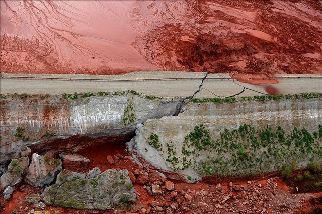
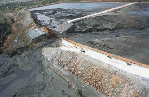
The classic example of this occurred on 25th April 1998 at the Los Frailes tailings dam in Aznalcollar in Spain. Good images of this event are hard to source, but this one is helpful (source):
The sequence of the failure at this site was quite complex (see description here), with the initiation occurring as a result foundation failure in a separation dam between two parts of the tailings pond. This occurred as a result of a failure on a weak plane in the foundation of the dam at a depth of about 14 metres. The dam slid forwards and cracked, allowing the release of the tailings, as this image (from here) shows:
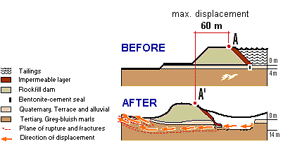
As can be seen above, the failure of the foundation of the dam caused it to be pushed forward by up to 60 metres. This accident was essentially a failure in design – i.e. the designers did not adequately consider the strength of the marl layers below the dam foundation and the likely build up of pore pressures in this area.
It is interesting to note the similarity between the images of the Ajkai Timfoldgyar and the Los Frailes events (compare with the image here), and also that the event in Hungary on Monday occurred after a prolonged period of heavy rainfall.
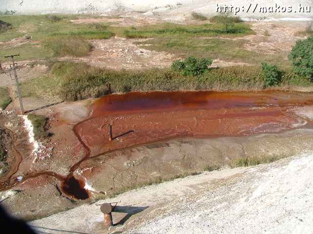
There is an excellent gallery of the downstream impact of this failure here.
Whatever the cause of this accident, far too many tailings accidents are happening around the world. As an illustration see the following previous posts on this topic:
Tailings dam failures and the price of commodities
Another Chinese tailings dam failure
A useful tailings dam failure resource
Another Chinese flowslide?
China tailings dam disaster death toll
The authorities really need to start to regulate this bette.
6 October 2010
Interesting images of the Ajkai Timfoldgyar tailings dam accident in Hungary
As predicted, a number of interesting images are now available of the site of the breach that caused the Ajkai Timfoldgyar tailings debris flow in Hungary on Monday. Thanks again to Peter Diehl for his tireless work in seeking out and highlighting the best images. The best slide show, surely destined to become an invaluable teaching aid, is available at this link:
http://galeria.index.hu/belfold/2010/10/05/legifelvetelek_az_atszakadt_gatrol/
In terms of the failure that caused this dreadful event, the best images are these two below. Take a little time to appreciate the scale of this – the first image has some machines in the foreground that provide perspective. The first image shows the breach itself:
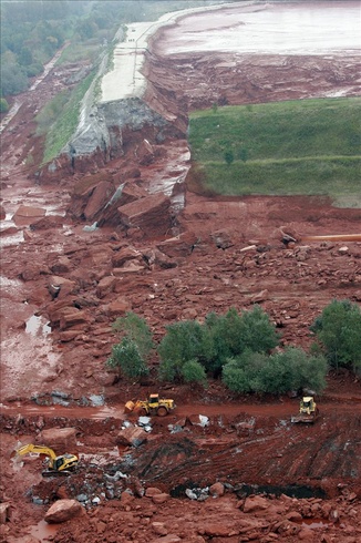
The really revealing image is this one – the breach is to the right of the image. It suggests that this block had moved off its foundation and that the section close to the reach had moved forward. Note the material that has come through the resultant crack:
The fact that the final failure occurred in a right angled bend in the dam wall is very interesting, as this is a point of stress concentration. If I were the team investigating this failure I’d be very interested to see the calculations of uplift force on the base of the dam.
5 October 2010
The Hungarian tailings dam accident – images of the failure of the impounding embankment
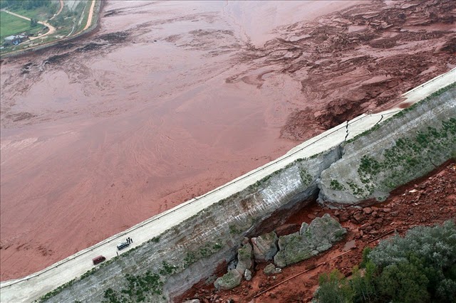
Thanks to both Peter Diehl, PeterOi and an anonymous commenter for pointing out the locations of images of the embankment that failed to release the landslide of toxic sludge in Hungary. The best one is probably this image, from Der Standard in Austria:
The failure appears to have occurred in the corner of the embankment, as shown in this Google Earth image:
I cannot quite work out the internal structure of the embankment from the image – it looks rather peculiar, but I’ll reserve judgement until better information is available.
Meanwhile, the mainstream media has finally cottoned onto the story, which now appears near to the top of the BBC News front page. The BBC article has a good image of the impact of the material downhill from the breach, paired with a map of the location:

The article also notes that there are now real concerns about this sludge causing an environmental disaster when and it it enters the river system; and that four people died and six remain missing.
 Dave Petley is the Vice-Chancellor of the University of Hull in the United Kingdom. His blog provides commentary and analysis of landslide events occurring worldwide, including the landslides themselves, latest research, and conferences and meetings.
Recent Comments