
25 October 2010
Landslides, forests and pandas – conservation and the Wenchuan earthquake
![]() The vast number of landslides triggered by the May 2008 Wenchuan earthquake, and in its aftermath has been extensively described, not least on this blog. One of the documented impacts of these landslides was the well-documented loss of habitat of the giant panda (A. melanoleuca) due to extensive forest loss. However, there is a great deal more to that story than meets the eye, as a newly-published paper by Vina et al (2010) describes. The research is very interesting, and has some quite substantial implications for landslide management in earthquake-prone areas.
The vast number of landslides triggered by the May 2008 Wenchuan earthquake, and in its aftermath has been extensively described, not least on this blog. One of the documented impacts of these landslides was the well-documented loss of habitat of the giant panda (A. melanoleuca) due to extensive forest loss. However, there is a great deal more to that story than meets the eye, as a newly-published paper by Vina et al (2010) describes. The research is very interesting, and has some quite substantial implications for landslide management in earthquake-prone areas.
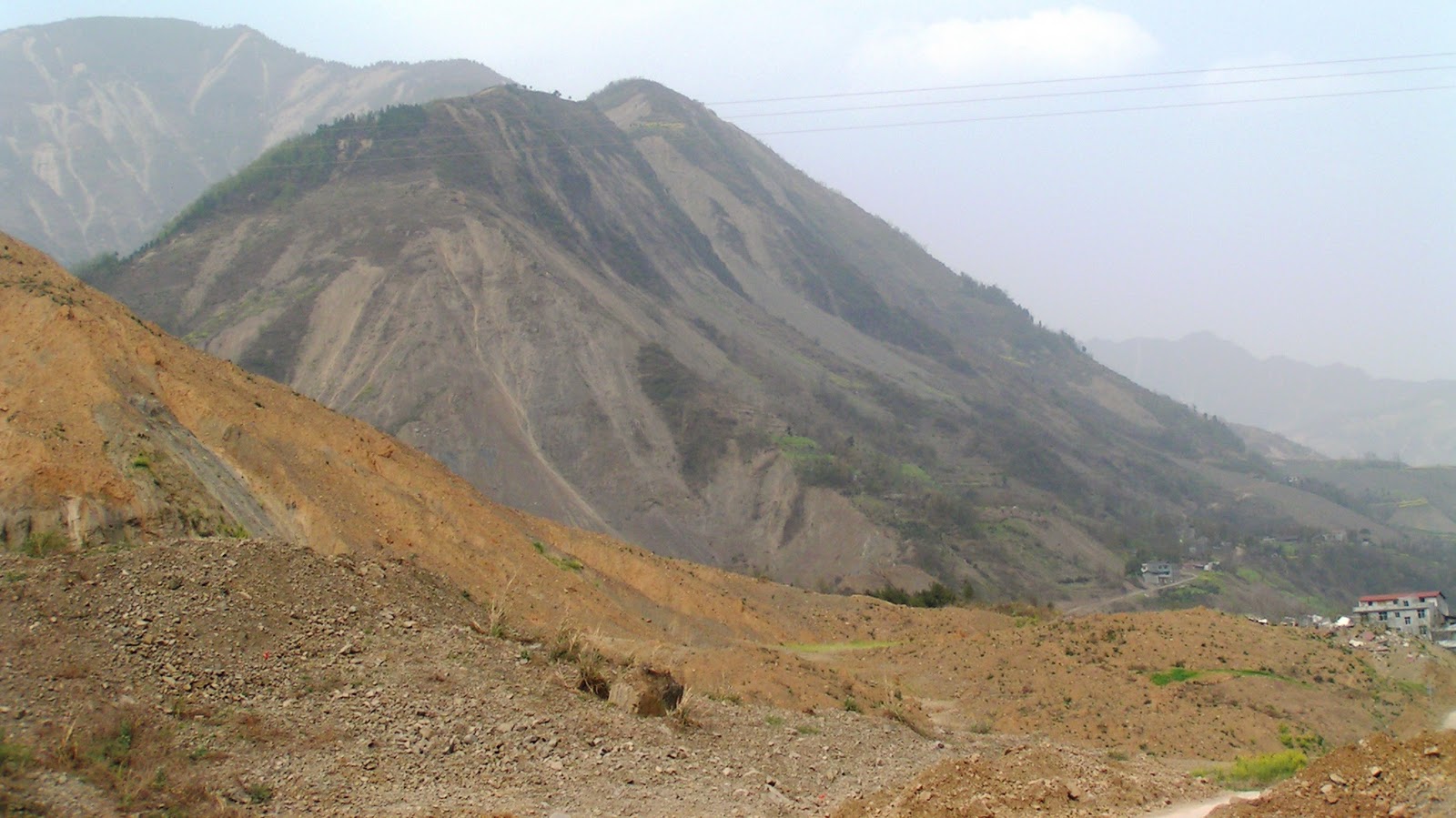
The study examines forested areas affected by the earthquake in Wenchuan County, in the main area affected by the earthquake. Wenchuan County includes Wolong, the famous giant Panda conservation area. The context for the study is important though – that is that contrary to popular understanding, the forested area of China has been increasing, not decreasing over the last decade or so. There are two key reasons for this:
- Economic growth has led to a huge migration of people to urban areas, reducing the pressure on rural resources;
- In the aftermath of the devastating floods in 1998, China started a huge programme of forest conservation and restoration, most notably incentivising farmers to return hillside croplands to forest.
So, the key question that this research has addressed is how the dynamics of forests in Wenchuan County. The research team mapped forest cover using Landsat TM satellite images acquired in 1994 and 2001 (i.e. before the conservation effort) and 2007. Augmented with higher resolution IKONOS and Quickbird images from 2000 and 2007. These images were used to map forest cover.
The results are fascinating. Between 1994 and 1991 the forest cover declined from just under 44% in 1994 to about 39.5% in 2001. However, by 2007 the forest cover was back to about 44%, showing that the conservation programmes had generated real results.
The earthquake of course reversed this trend. In the aftermath of the seismic event the forest cover was again mapped using Landsat TM images. The results suggest that 192.6 square kilometres of forest were lost in Wenchuan County, representing just under 11% of the forest cover in 2007. The consequence was that forest cover declined to about 39%. However, the authors estimate that without the conservation programmes this would have been as low 33.5%. Thus, although the occurrence of landslides in the earthquake was truly dreadful, the ecological picture would have been far worse if it hadn’t been for the forestry programmes. One aspect that the paper does not cover though is that the loss of forestry increasing seismic landslide susceptibility, and thus the loss might have been greater again
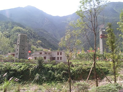
The authors finish by speculating on the long term recovery of the forest resources in the aftermath of the earthquake. They note that the construction of new housing, such as that shown to the left (from my recent trip to the area), is likely to have the effect of moving people away from the more remote rural areas, which may well result in the abandonment of more farmland, and thus increased forest recovery. This may well have substantial benefits for conservation efforts, albeit at potentially high cost to those people most affected by the earthquake.
Reference
Viña, A., Chen, X., McConnell, W., Liu, W., Xu, W., Ouyang, Z., Zhang, H., & Liu, J. (2010). Effects of Natural Disasters on Conservation Policies: The Case of the 2008 Wenchuan Earthquake, China. AMBIO DOI: 10.1007/s13280-010-0098-0
24 October 2010
Landslides from typhoon Megi in Taiwan
The passage of typhoons past or across Taiwan often leads to the generation of exceptionally high rainfall totals that, when combined the steep topography and weak rocks, inevitably triggers extensive landsliding. The late season typhoon Megi, whose erratic course meant that it somewhat unexpectedly brought heavy rainfall to Taiwan at the end of last week, was no exception:
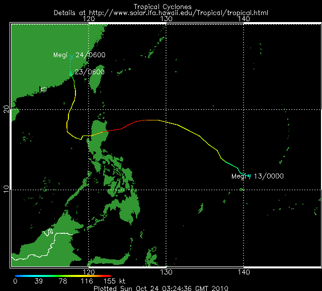
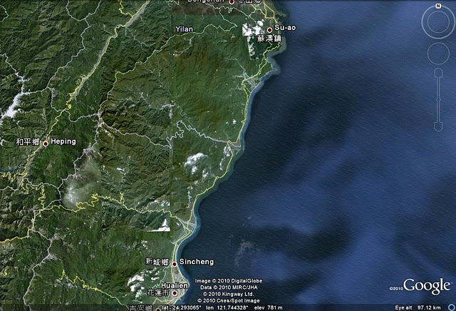
Over a 48 hour period the typhoon brought over 1200 mm of rainfall to parts of NE Taiwan. This area is home to one of the world’s most spectacular coastal roads – the so-called Suhua Highway, which runs along the east coast from a Su-ao in the north to Hualien in the central east of Taiwan:
This road is popular with tourists both because it is a logical route back to Taipei for a round island tour and because the scenery is spectacular (image from here):
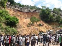
Unfortunately however, this is a very dangerous stretch of road in the heavy heavy rainfall associated with typhoons. During Megi, this is the area that received the most intense rainfall, with the inevitable consequence of extensive rockfalls, rockslides and debris flows. Unfortunately, it appears that a tourist bus carrying 21 people was travelling down the highway at the time of the heaviest rainfall. This bus, which was carrying 19 tourists from mainland China plus their driver and tour guide, is now missing. The bus is likely to have been either buried by a rockslide or to have been involved in a landslide below the road, and thus to have been carried into the sea. The likelihood of survival is very low. Another tour bus was also involved in a rockslide, as shown in the image below (from here).

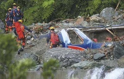 In this case the passengers escaped, but the driver and tour guide are also missing. Finally, two other vehicles, and their three occupants, are also missing.
Meanwhile, a further nine people were killed in a landslide in Ilan, the main town to the north of the Suhua Highway, when a landslide hit a temple.
21 October 2010
The curious story of the Rajang log jam in Sarawak, Malaysia
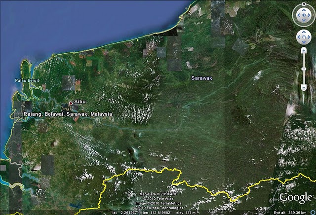
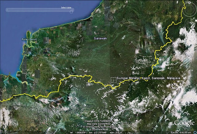
An interesting if somewhat strange story has developed in Malaysia over the last few days. The Rajang River flows over a distance of about 560 km across Sarawak. It is fairly obvious on this Google Earth image:
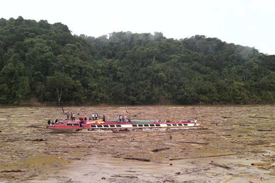
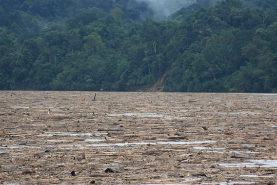
A fortnight ago reports emerged that there were navigation problems on the lower reaches of the river. Unusually, these issues occurred not because of high or low river levels, but because the river was choked with wood (a logjam). These impressive images, from http://hornbillunleashed.wordpress.com/2010/10/08/10352/ illustrate the magnitude of the issue. The blockage reportedly extended for 250 km.
The reason that the wood entered the river appears to have been intense rainfall on 6th to 7th October, but the question is where the wood has come from. There are two likely sources of wood like this. The first is that a logging camp or store was inundated (unlikely on this scale); the second is extensive landslides. In Malaysia right now a huge blame game is playing out over the cause of the disaster. The Land Development Minister, James Masing, has claimed that the cause was logging in the catchment. Meanwhile, the state forest director, Len Talif, is blaming shifting rainfall patterns.
The source area appears to have been Sungai Melatai in the Balleh subcatchment, shown here:
Some reports suggest that there was a very large landslide event in this catchment:
A man from Sungai Melatai, a tributary of Baleh River, gave the following account of the cause.
“The cause of the ecological disaster and the extensive environmental damage has nothing to do with the rain or rising water level because on the day it happened the water level along Baleh River was low and normal. There was extensive landslide of between five and 10km on both banks of Sungai Melatai. This has nothing to do with farming activities. It is caused by human disregard for the environment through extensive logging activities.” A child died when its mother could not send it for medical treatment in Kapit due to the logjam. Two men in a Land Cruiser died in the landslide.
and
When contacted, the Superintendent of Land and Survey Kapit Affin Bawi said the massive landslide was the culprit. His view was confirmed by an officer from Sarawak Rivers Board. An elderly casual worker identified as Jilan explained that the Ibans described the phenomenon as ‘baruas’ or massive landslide affecting a huge area, when nature gives way.
It is clear that some sort of large landslide event – either a very large slide, or many smaller ones, or even both of those at the same time – has occurred in this catchment. It would be very interesting to know just what has occurred.
Update on the move to the AGU blogspace
The move to the AGU site has been delayed by a few days to allow some minor technical gremlins to be cleared. As a result I do not anticipate moving to the new location (and name) until early next week now. I will continue to post here as the primary location until at least Monday.
20 October 2010
One day to go…
As you are probably aware, this blog is about to migrate to an AGU hosted web site. All being well, the blog will move late tomorrow (21st October). I am hoping that there will be no interruption along the way. I will post the new location in the next few hours and plan to run the two sites in parallel for a few weeks.
One minor change that I have decided to implement is that the blog on the new site will be called “The Landslide Blog” rather than “Dave’s Landslide Blog”.
19 October 2010
Two fatal landslides in the earthquake affected areas of Haiti
Problems continue in the earthquake affected areas of Haiti, where over 2 million people remain essentially homeless 10 months after the devastating earthquake. Reporters Live are carrying a story that heavy rainfall in the last 48 hours has triggered two, rather different fatality-inducing landslides:
1. A collapse in a sand quarry
Illegal quarrying of sand to be used for rebuilding is turning into a major, if unsurprising, problem in the hills around Port-au-Prince. The reports suggest that such a quarry to the west of Port-au-Prince collapsed in the heavy rainfall, killing eight people including two children.
2. Landslide in Carrefour
Meanwhile the article also notes that a second landslide, this time in Carrefour, killed four people and left a further three missing. The report also suggests that “residents likewise said that there had been unreported mudslides that occurred in the last few weeks”.
So far this year, Haiti has not been hit by a major hurricane, although we are not quite out of the woods yet. Unfortunately, the extreme vulnerability to heavy rainfall of both the landscape and the population is going to be a long lasting legacy of the earthquake.
Typhoon Megi and the Philippines
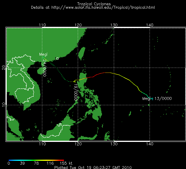
In the last 24 hours Typhoon Megi has tracked from east to west across northern Luzon in the Philippines (map from here):
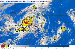
At the time of landfall this was a true super typhoon. Even in its current weakened state it is generating gusts of up to 195 kph. Inevitably, it has brought very heavy rainfall to the north of the Philippines, although to date there is no news of any large landslide accidents. However, at the moment the storm appears to be stalled just offshore (see PAGASA satellite image below), which is the scenario that often leads to prolonged intense local rainfall and thus significant slope problems.
Tropical Storm Risk are forecasting that this typhoon will track northwestwards and will strengthen to landfall to the west of Hong Kong. If this forecast is correct then there must be the potential for substantial landslide and flood occurrence in southern China in the next few days.
5th Canadian Conference on Geotechnique and Natural Hazards
Thanks to Rick Guthrie for pointing out in a comment another interesting Canadian conference on natural hazards. This is the 5th Canadian Conference on Geotechnique and Natural Hazards, also known as Geohazards 5, which will be held in Kelowna, British Columbia on 15th to 17th May 2011.
The call for abstracts closes on 29th October, and includes papers on the following:
- Seismic hazards
- Flooding and natural dams
- Landslides
- Quantitative risk assessment
- Snow and rock avalanches
- Technology and geohazards – monitoring and remote sensing
- Geohazards in a changing climate
- Tsunamis
- Early warning & response
- Urban hazards and policy development
- Volcanoes
Details are available at the conference website:
http://www.geohazards5.ca/program.php?lang=en
With sesveral landslide sessions at the AGU Fall meeting in December, multiple landslide sessions at the EGU General Assembly in April, Geohazarads 5 in May, and Slope Stability 2011 in September the next 12 months look excellent for landslide meetings. Further out, we have the 11th International Symposium on Landslides in May 2012.
See you there!
17 October 2010
Updated: Attabad – NDMA make a full set of reports available online, plus an article in the Economist
The National Disaster Management Agency (NDMA) in Pakistan have now made four reports about Attabad available online here. These are as follows (with the correct links to each):
- The dam break study undertaken by NESPAK.
- A report by Alessandro Palmeiri, from the World Bank
- My report on the landslide.
- A report by the Geological Survey of Pakistan dating from before the landslide event about the hazards at the site.
Interestingly, although my report is included NDMA have not asked my permission to post it there, and nor did they inform me that they had done so. Indeed, at no stage have they communicated with me about Attabad, beyond a single line reply to an email that I sent to them. However, I am pleased that my report is easily available.
Update: The Economist has today also published a short article on Attabad, which is available here. Meanwhile the Express Tribune reports that the long-promised compensation will finally be paid to the local population, and that deepening the spillway will start within a month. Finally, there are two Attbad related papers being presented at the forthcoming AGU conference in San Francisco:
- Hunza Landslide and Monsoon Flooding in Pakistan Call for International Attention to Transboundary Natural Hazards by J. S. Kargel; W. Fink; R. Furfaro; G. J. Leonard; M. Patterson.
- Satellite Monitoring and Characterization of the 2010 Rockslide-Dammed Lake Gojal, North Pakistan. by G. J. Leonard; J. S. Kargel; R. E. Crippen; S. G. Evans; K. B. Delaney; J. F. Schneider
16 October 2010
Round up of landslide stories and events for the last week
In weeks in which I have been too busy to post a great deal of material, I often provide a summary of interesting landslide events around the world. This is the summary for the last week:
1. A very strange landslide in Germany
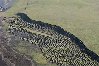
Thanks once again to Peter Diehl, the prize for bizarre landslide event of the week goes to a very strange event at a former lignite mine near Hoyerswerda, Saxony, Germany on Wednesday. The slide appears to be similar to a quick clay slide, but on a very large scale – the surface area affected is 110 hectares. This event did not seem to make the English language news, but a German report can be found here. Fortunately no-one was killed, but 84 sheep were lost. The best images of the event are at this page – also in German. Click on the “Fotogalerian” link in the box on the left side, half way down the page. The two images here are from that source.

The red box shows some trucks caught in the landslide.
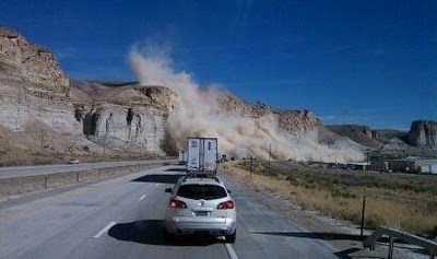
2. An interesting rockfall in Wyoming
Thanks to Lisa Denke for this one. There is an terrific gallery of images of a rockfall event in Wyoming on Interstate 80, also on Wednesday, available at the trib.com site. According to this article, the cloud of dust generated by the rockfall (see below), which came from a bluff known as the Palisades, reduced visibility to the extent that several motor collisions occurred, injuring four people.
3. Climate change and landslide story of the week
Regular readers will know that there is no doubt in my mind about the reality of the link between human releases of greenhouse gases and increases in the global temperature. However, I continue to greatly frustrated by some aspects of the way that this issue is handled. The latest example is a story being run by a number of media outlets, such as this one (in New Scientist, which surprises me), under the headline “A warming world could leave cities flattened”. The basis of this is a perfectly respectable paper in Global and Planetary Change that looks at a very large volcanic flank collapse in Chile. From this is spun a surprisingly strident headline on an issue that is not even mentioned in the paper. Indeed the words “city”, “cities” and “urban” do not appear anywhere in the paper, as far as I can see.
hmmmmmm!!!!
 Dave Petley is the Vice-Chancellor of the University of Hull in the United Kingdom. His blog provides commentary and analysis of landslide events occurring worldwide, including the landslides themselves, latest research, and conferences and meetings.
Recent Comments