

25 March 2014
The Steelhead landslide in Oso, Washington State
The Steelhead landslide
The death toll from the Steelhead landslide near to Oso in Washington State is continuing to rise. Latest reports suggest that there are now 14 known fatalities, but 176 people are reported to be missing. It is quite normal in this sort of event for the number of reported missing people to exceed substantially the actual number of victims, so this maximum toll may reduce in the next few days. However, it is still likely to be the costliest landslide in terms of lives lost for many years in the USA.
Details are slowly emerging of the landslide history of this site. It is clear that major landslides have occurred here on many previous occasions; indeed so much so that the landslide is known as either the Hazel landslide or the Steelhead landslide; at this stage I am opting for the matter given that the inundated area is known as Steelhead Drive.
Better images of the Steelhead landslide
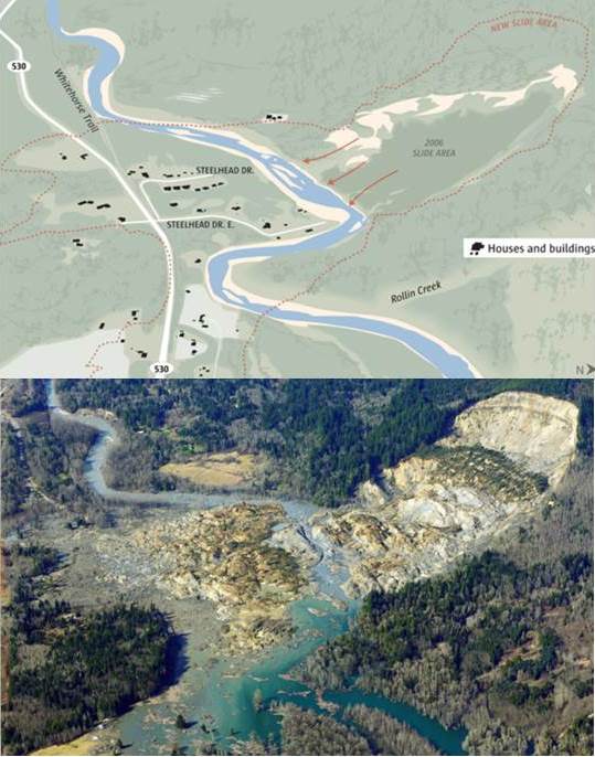
I very much appreciate the help that numerous people have given me over the last few days to put together this post – too many to name, but thanks to you all. The best graphic that gives an overview of the slide is in the Seattle Times:
..
The original version has a very impressive slider function that allows the user to flip from one image to the other. I can’t replicate that, but putting the two images side-by-side shows the extent of the devastation. The number of inundated houses is large, suggesting that the loss of life will be high, especially bearing in mind that the slide occurred on a Saturday.
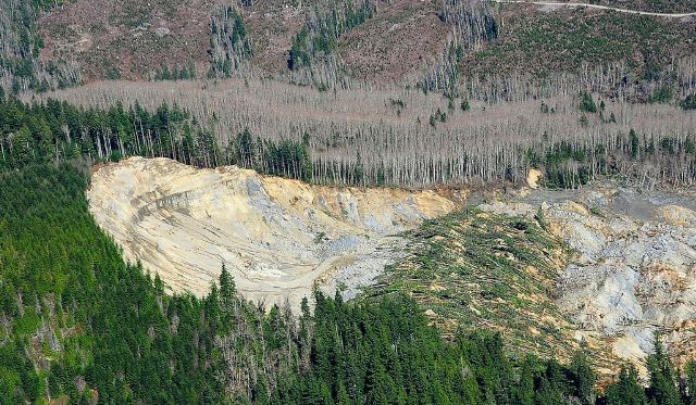
The best set of aerial images of the slide are on the Flicker page of Governor Jay Inslee – there are some wonderful images there. This image shows the source of the landslide:
..
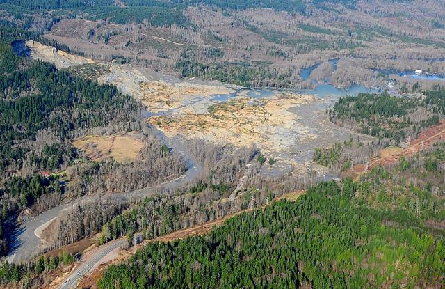
Whilst this image from the same source shows the entire landslide mass.
..
The landslide has been widely reported as a mudslide. In terms of the lower portion, which did the damage, this is correct, although in places it might have been more of a mudflow than a mudslide. However, the upper portion is a rotational landslide – the rotated block with the fallen trees is very clear. A working hypothesis would be that this block failed catastrophically, transferring load onto the block below, which in turn generated very high pore water pressures, causing fluidisation and a very rapid mudflow that struck the settlements across the river.
The history of the Steelhead landslide
The Yakima Herald has a very nice article that details the chronology of events on the Steelhead landslide. This includes:
- 1949: A large landslide (1000 feet long and 2600 feet wide) affected the river bank
- 1951: Another large failure of the slope; the river was partially blocked
- 1967: Seattle Times published an article that referred to this site as “Slide Hill”
- 1997 report, by Daniel Miller, for the Washington Department of Ecology and the Tualialip Tribes
- 1999: US Army Corps of Engineers report by Daniel and Lynne Rodgers Miller that warned of “the potential for a large catastrophic failure”
- 25 January 2006: large movement of the Steelhead landslide blocked the river
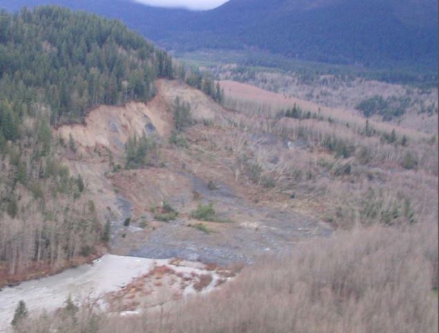
There is a good presentation about the 2006 landslide available online (NB pdf). This includes the following (somewhat blurry) image of the source of the 2006 landslide:
http://www.stillaguamish.nsn.us/Publish/Steelhead%20Landslide.pdf
..
The slope that formed the scarp of the 2008 slide was undoubtedly very over-steepened, and of course was formed from weak materials. This looked like an accident waiting to happen.
24 March 2014
Oso landslip: useful resources and the rising human cost
Oso landslip costs
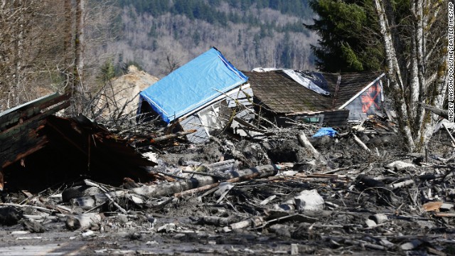
Unfortunately the toll from Saturday’s Oso landslip is rapidly mounting. Latest reports suggest that at least eight people have lost their lives and that up to 18 more might be missing in the debris. Unfortunately, the site remains very dangerous, such that substantial areas have yet to be entered. This will be the worst landslide in the USA for many years. The last event on a similar scale of which I am aware was the 25th December 2003 debris flow in San Bernadino County, California, which killed 16 people. It looks likely that this landslide will be worse.
 ..
..
Oso landslip resources
Whilst I am referring to this as the Oso landslip, in fact it is a reactivation of an existing landslide, known as the Hazel Landslide. This landslide is known to have moved 1988, and went through a second phase of movement in 2006. It is well described in a blog post from 2009 that can be found at: https://slidingthought.wordpress.com/tag/north-fork-of-stillaguamish/
You can find a geological map of the area here: http://www.dnr.wa.gov/Publications/ger_ofr2003-12_geol_map_mounthiggins_24k.pdf
The landslide did occur in glacial sediments, as I indicated might be the case yesterday. There are some excellent resources on the landslide at the following three blog posts:
http://washingtonlandscape.blogspot.com/2014/03/arm-waving-notes-on-stilliguamish.html
http://washingtonlandscape.blogspot.com/2014/03/geology-of-silliguamish-blocking-slide.html
http://washingtonlandscape.blogspot.com/2014/03/aerial-history-and-lidar-of.html
23 March 2014
Oso landslide in Washington State: three people killed and the river is blocked
Oso landslide
A very large landslide occurred yesterday morning near to the town on Oso in Washington State, USA. Unfortunately, three people have been killed by the Oso landslide, and newspaper reports suggest that three survivors, including a six months old boy, are in a critical condition, and that two more people have been seriously injured. At present it is not clear as to whether there may be other victims in the landslide debris.
The best set of images of the slide is to be found on the Seattle Pi website, which includes this overview shot:
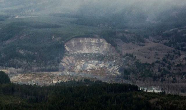
Image from Seattle Pi
..
The landslide is complex, but appears to have occurred in weak sedimentary deposits; I would guess with a glacial origin. The landslide appears to have a large arcuate scar with a large, rotated and partly disaggregated central block:
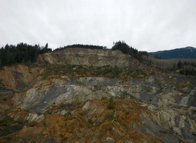
Image from Seattle Pi
..
The toe of the landslide appears to have fluidised and flowed laterally (i.e. up and down the valley), suggesting that the landslide would have been rapid and highly destructive, which accounts for the fatalities:
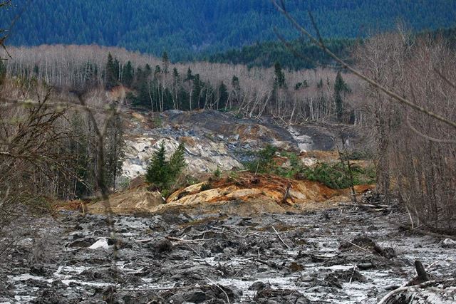
Image from Seattle Pi
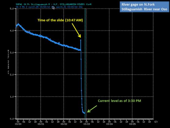
There can be little doubt that this is a rainfall triggered landslide, though given its size there might have been a substantial time gap between the triggering event and the slide itself whilst pore pressures built up. An interesting aspect of the landslide is that the valley is now blocked. National Weather Service Seattle tweeted the gauging station data for the north fork of the Stillaguamish River downstream from the landslide:
NWS Seattle
..
The very rapid decline in water depth is very clearly apparent, but note also the short but dramatic spike in water depth immediately after the landslide, presumably caused by a surge of water induced by the slip entering the river. A key management task over the next few days is likely to be the creation of a bypass channel to reopen the river.
Acknowledgements
Thanks to John Garver, Lee Allsion, Peter Weisinger and Bryan O’Sullivan for helping me to track down the material for this post.
21 March 2014
The Randa rockslide – a spectacular new video
The Randa Rockslide
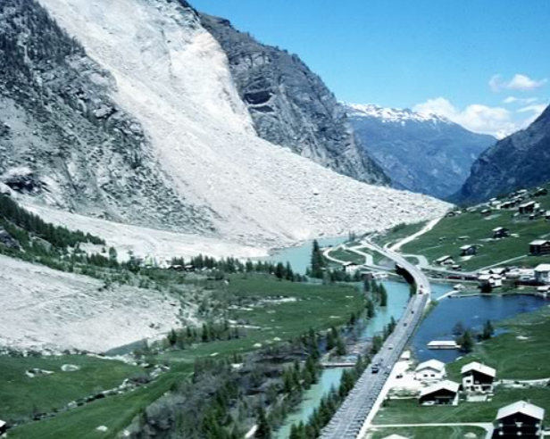
The Randa rockslide in Switzerland is probably one of the best known and most intensively investigated landslides in the world – so well known that it even has its own wikipedia page! The main action occurred in two collapse events in April and May 1991:
Staubwolke Randa, Andreas Götz PLANAT 1991
..
The Wikipedia page summarises the events well:
The 1991 rockslides at Randa consisted of two separate collapse events on April 18 and May 9, which released in total a cumulative volume of approximately 30 million cubic meters of rock. The elevation of the top of the scarp is 2320 m (7610 ft), while the elevation of deposit toe is 1320 m (4330 ft).
Accelerating occurrences of small rockfalls from the cliff in the decades preceding the slides gave indication of deeper movements, and fallen debris had eventually destroyed much of the forest beneath the cliff (Sartori et al., 2003). Precursory events noted immediately prior to the April, 1991 rockslide included explosive ruptures of rock slabs and new forceful water discharges from the face (Schindler et al., 1993).
April 18, 1991: This primary rockslide event occurred over the span of a few hours time, producing a large steep debris cone and a thick layer of dust over the valley. The rockslide consisted of a progressive succession of smaller collapses and block failures involving first the lower and more competent orthogneiss, followed by retrogressive collapse of the highly-jointed paragneiss above (Schindler et al., 1993). The total volume released during this rockslide phase was estimated to be 22 million cubic meters. Had this volume been released instantaneously, a devastating rock avalanche and far reaching deposit would have resulted. A lesser failure followed on April 22.
May 9, 1991: Monitoring of deformation and microseismic activity led to accurate anticipation of this follow up rockslide event. The rockslide again occurred in a progressive manner over the course of a few hours, involving many small volume collapse events mostly within the upper paragneiss material (Schindler et al., 1993). These failures resulted in retreat and reduced the inclination of the upper part of the rockslide scarp. The total volume released in this second phase was estimated to be 7 million cubic meters.
No one trigger can be conclusively assigned as responsible for the Randa rockslides of 1991. The area has experienced a long history of moderate seismicity, but no significant earthquakes immediately preceded the failures. A warm period producing ample snow melt occurred in the days prior to the April rockslide, and water could be seen emanating from springs on the rock face. Further, a period of rapid cooling occurred just one day before the April slide. However, it is unknown if this series of events combined to act as an exceptional trigger, or if they were rather part of the normal seasonal climatic and hydraulic cycles (Sartori et al., 2003).
Since the 1991 failures, the site of the rockslide has been investigated in detail by the brilliant Engineering Geology team at ETH led by Simon Loew.
A video of the April 1991 Randa landslide
The reason for posting this is that a new video has appeared on Youtube that shows the 1991 collapse event as it occurred. The quality of the video is not so good, but the content is truly amazing:
..
..
This illustrates beautifully the retrogressive nature of this type of collapse (i.e. it occurs sequentially rather than all in one go), and the way that a collapse on this scale means that the debris starts to behave in a way that at least superficially looks like a fluid.
20 March 2014
Dawlish: inducing landslide failure using firehoses
The Dawlish landslide
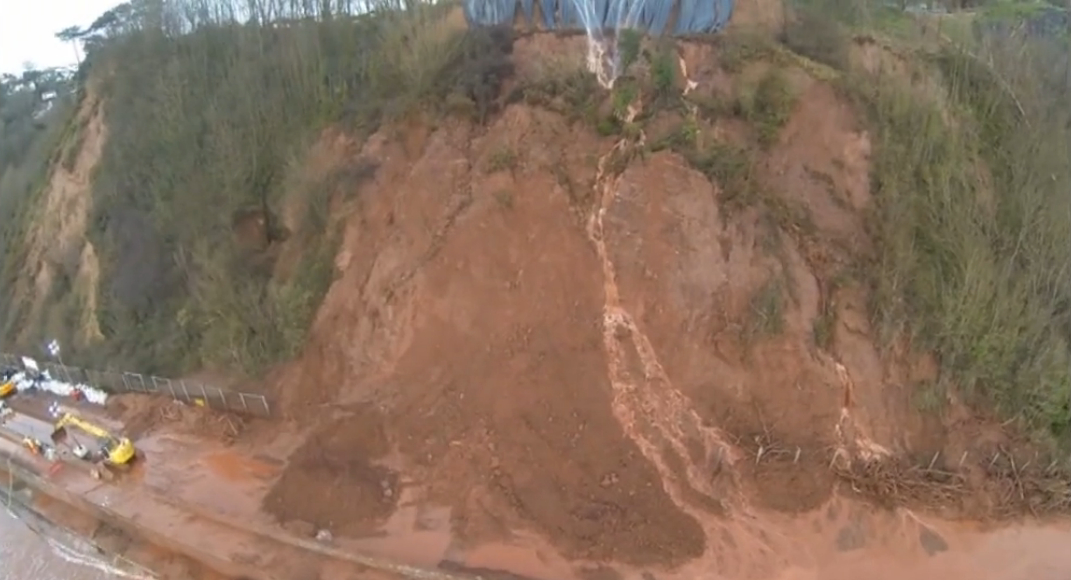
The Dawlish landslide is one of the many problems that arose on the mainline railway line that links the southwest of England with London. This is a historic line that takes a very challenging route along the coastline. It has a long history of landslides, as my earlier Landslides in Art posts showed. In the recent winter storms a large section of track washed out, and a series of landslides have also caused significant problems. Clearly Network Rail (the track managers) would like to reinstate the track quickly and to have a long term solution, both of which are difficult. One key problem is a large (reportedly 30,000 tonnes, although some sources have suggested it is even larger) slide above the line. The landslide is shown in a very nice drone / UAV video collected by the BBC and available via the Eyes of Dawlish Facebook page. This is a screenshot of the landslide from that video:
..
Mitigating the Dawlish landslide
On first inspection the slide looks to be a slump – there is certainly a large displaced block. Network Rail have started an attempt to deal with this landslide that can best described as being impressive and perhaps even audacious. Since the weekend they have been using high pressure fire pumps to push water into the landslide in order to induce failure – if you look carefully you can see this ongoing operation in the image, with several streams of water being pumped onto the slide. Presumably the intention is to fail the landslide onto the track, and then to remove the debris.
This type of approach is occasionally proposed for landslides, but is rarely attempted. There are several reasons for this. First, actually it is rather difficult to get a natural slope to behave as you want it to. So, for example, there is a risk that the slide might partially fail and then stop, leaving an unstable mass that is dangerous to clear. Or the failure might be larger than expected, though that is unlikely here. The greatest danger is that the landslide does not move at all, leaving a now even less stable lump of rock above the asset in question.
I am not sure what is going on at Dawlish. Today the Herald Express reports that the army are involved in the operation, according to the BBC perhaps even using armoured excavators to clear the debris. It will certainly be interesting to see how this pans out over the next few days, and I am in admiration of Network Rail for what they are doing at that site.
18 March 2014
Workshop on physical processes and mechanisms of precipitation-induced landslides
Precipitation-induced landslides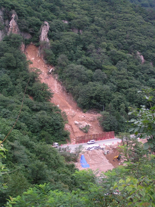
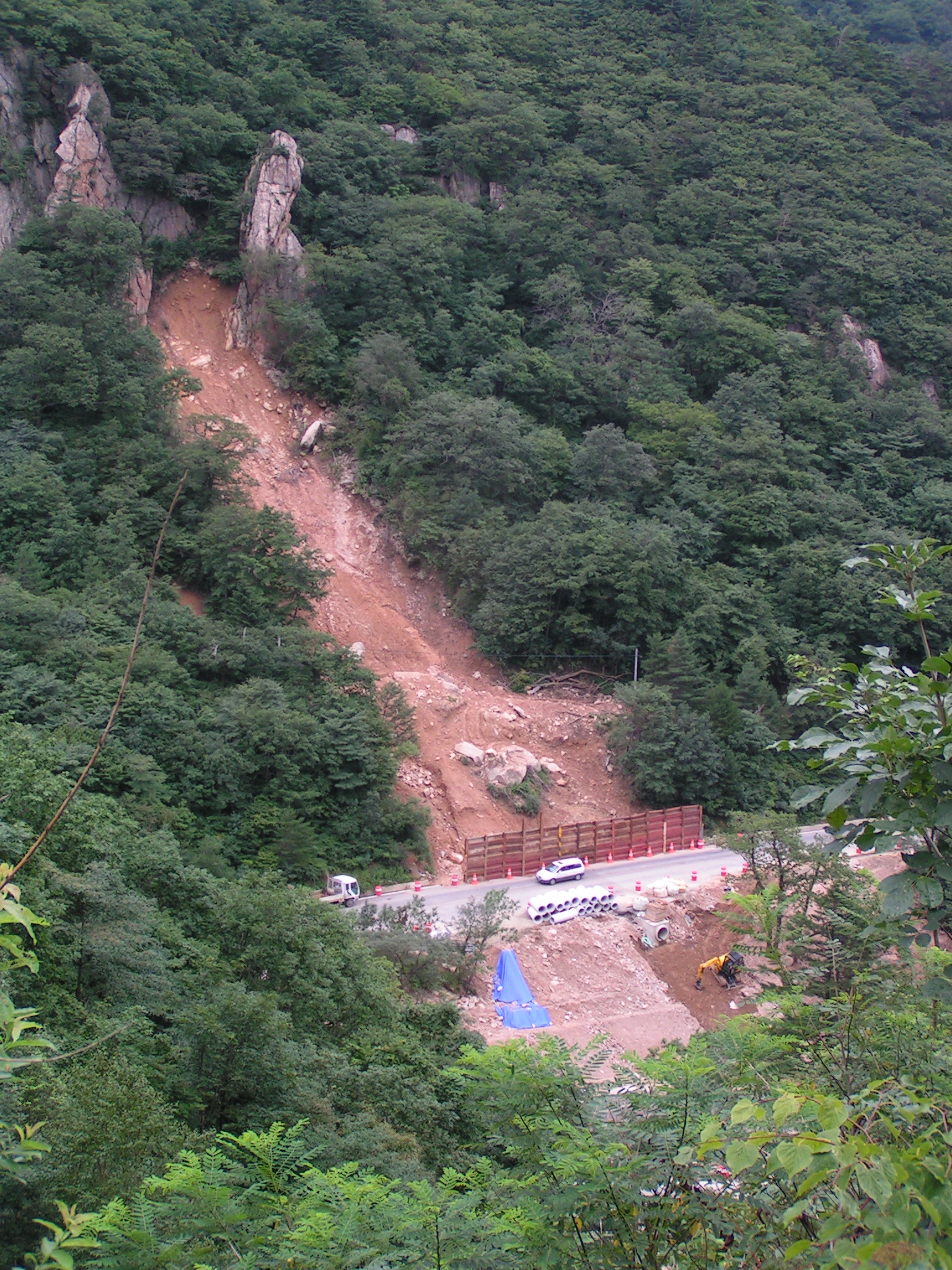
Every year several thousands of people are killed by precipitation-induced landslides, such as the one shown adjacent, which occurred in South Korea a few years ago. Fortunately, this one did not cause any loss of life.
In late November this year, JTC-1 (the joint technical committee on natural slopes and landslide set up by ISSMGE, ISRM and AIEG) will organise a workshop on precipitation-induced landslides. This will be held at the University of Seoul in South Korea from 24 to 26 November. It will be followed on 27 November by a forum on “slope safety preparedness for the effects of climate change” and a half day meeting that will examine recent fatal landslides in Asia. On 28 November there will be a one day field trip.
The full programme is given below:

You will see that this meeting is intended to be a workshop of limited size with lots of discussion rather than a large-scale conference. In my experience this type of event is the most rewarding to attend.
Call for abstracts
The organisers of the meeting have put up an initial website. This includes a call for abstracts, which are due on 31st March. Further details will be provided on the website in due course.
17 March 2014
Mount Haast: A GNS report on the 2013 rock avalanche (which is also known as the Mount Dixon rock avalanche)
Mount Haast rock avalanche
A little over a year ago Neil Wiltshire, a British climber, captured on video a rock avalanche on the flanks of Mount Haast (although at the time this was reported as being from Mount Dixon). I posted a couple of times on this landslide. The full video, surely one of the most remarkable ever collected, is still available on Youtube:
..
Last year, Graham Hancox and from GNS Science and Roydon Thomson, a local engineering geologist, wrote a report (Hancox and Thomson 2013) on this landslide, which has now been made available online (NB pdf). The report also covers another landslide, which occurred two weeks earlier at Ball Ridge, 9 km from Mount Haast) a fortnight or so earlier. I do not intend to discuss that landslide here.
The characteristics of the Mount Haast landslide
Although the video and subsequent analyses are the main sources of information about the landslide, the report also includes this image, collected by Anna Seybold, od the landslide in motion:
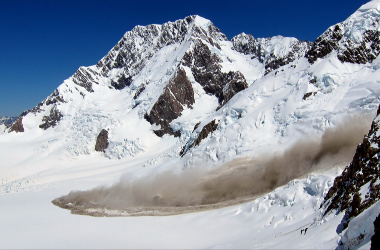
Photo: Anna Seybold, from Hancox and Thomson (2013)
..
This image is really interesting as it appears to capture the transition from turbulent rock avalanche to rapid sliding. If you view this image alongside the video it is clear that the front of the landslide appears to have just started to slide. The report suggests that at its peak the landslide was moving at about 150 km/h. The landslide characteristics are as follows:
- Source area width: 200-250 m
- Source area height: 350-400 m
- Source thickness: 5-25 m
- Initial volume: 575,000-980,000 cubic metres
- Average velocity (from seismic data): 160 km/h
- Runout distance: 2.9 km
- Deposit volume: 2 million cubic metres (NB this is larger than the source volume because of entrainment en route)
The report has very nice before and after images of the landslide:
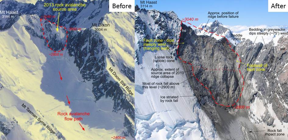
Images from Hancox and Thomson (2013)
..
But perhaps the most useful part of the report is the combination of these two images, the one on the lefty showing the landslide track and the one on the right providing a long section of the slide:
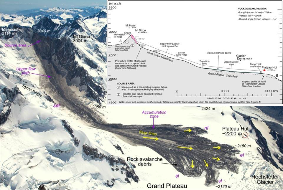
Adapted from Hancox and Thomson. Photo by Mark Watson
..
What is beautifully shown in this image are the four phases of movement:
- Initial freefall
- Rock avalanche, characterised by a steep track and dust deposits on both sides. When the gradient reduced this transitioned to…
- Rapid sliding, during which the main body developed very clear flow lines
- Slow sliding, in which the deposit developed the lobate frontal structure and entrained fresh snow and ice.
There is a great deal more in the report, including a very interesting discussion about causation and triggering. I recommend that you download a copy.
Reference
Hancox, G.T. and Thomson, R. 2013. The January 2013 Mt Haast Rock Avalanche and Ball Ridge Rock Fall in Mt Aoraki/Mt Cook National Park, New Zealand. GNS Science Report 2013/33. 26 pp.
13 March 2014
The Mount La Perouse landslide: new images
The Mount La Perouse landslide: a Pleaides image
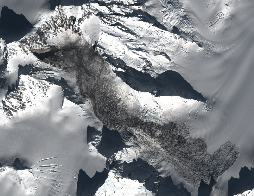
Last week Marten Geertsema flew up to the Mount La Perouse landslide in Alaska. He has very kindly made a set of images that he took from the air and on the ground available. Marten and Colin Stark also arranged the acquisition of a Pleaides high resolution satellite image. Colin has kindly generated this image of the landslide, which gives a fantastic overview of the slide:
Pleaides image courtesy of Colin Stark
..
The source area of the Mount La Perouse landslide
This image shows the source area of the Mount La Perouse landslide. Note the structure in the rocks behind the failure scar. The general geological structure here is an anticline, the core of which has been eroded out by the glacier to form the valley. Thus, the basal shear surface of the landslide is the natural structure in the rocks, with the form of the anticline allowing the plane of weakness to daylight. The rear scar appears to have been defined by a sub-vertical joint. Thus, the landslide itself is a giant wedge; it is perhaps inevitable that this slope was showing some signs of distress prior to failure:
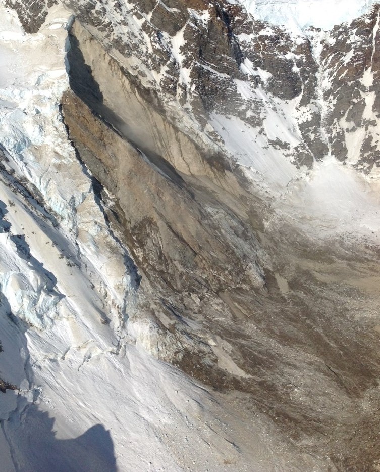
Image courtesy of Marten Geertsema
..
The material that formed the Mount La Perouse landslide
The rock material that formed the initial failure of the landslide was gabbro according to the geological maps (hat-tip to Colin for digging that information out). However, upon impact at the foot of the slope this is likely to have shattered and then to have entrained snow and ice. The resulting deposit at the foot of the slide is thus a complex mixture, which appears to consist of a matrix of dirty ice (possibly slush during the movement?) with clasts of intact ice and gabbro (note the handle of an ice axe for scale):
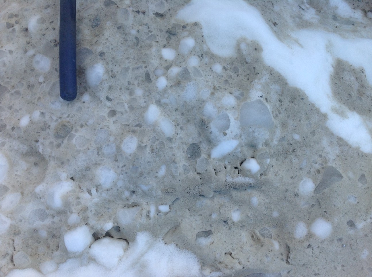
Image courtesy of Marten Geertsema
..
The Mount La Perouse landslide track
An interesting aspect of the Mount La Perouse landslide is its behaviour upon impacting the valley floor. The satellite images show considerable super-elevation – i.e. it ran up the far side of the valley before turning to flow downhill. This image shows the run up on the opposite valley side:
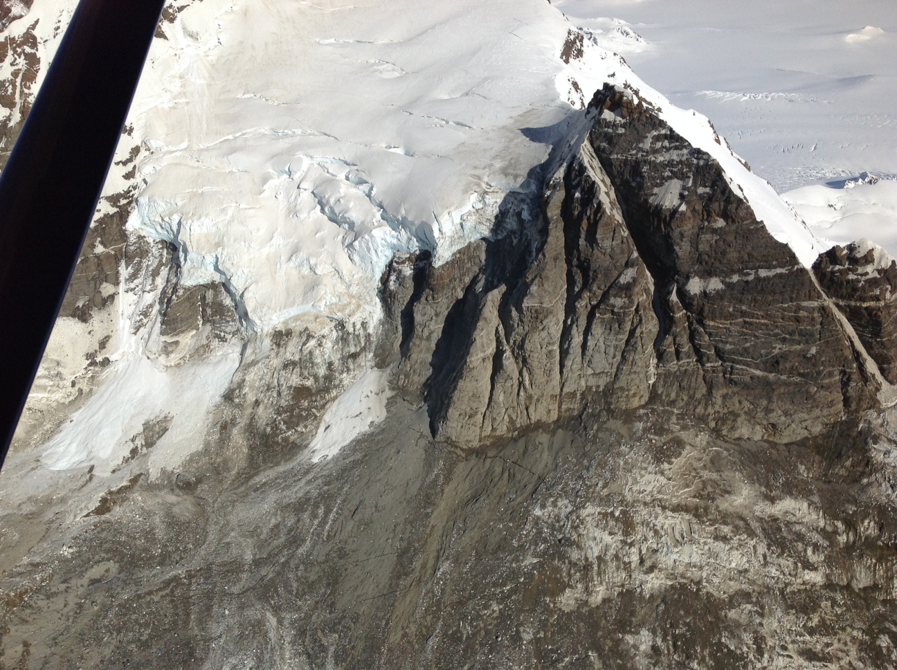
Image courtesy of Marten Geertsema
..
The slide then travelled down the valley, but with a rather complex flow pattern en route:
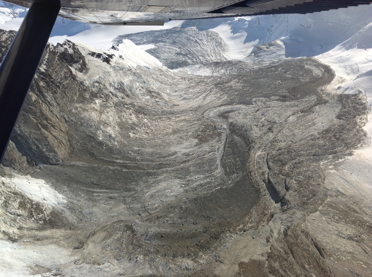
Image courtesy of Marten Geerstema
..
There is a great deal of work to do to understand this landslide properly, and it does deserve a detailed investigation. Unfortunately, snowfall is likely to mean that it will soon be difficult to work on it.
11 March 2014
Forthcoming lectures: Leeds (tonight!), Durham, and Cockermouth
In the next week or so I’ll be giving or chairing a number of lectures and events:
1. Yorkshire Geotechnical Group, Leeds
I’m giving a talk tonight to the Yorkshire Geotechnical Group entitled “Managing very large landslides”. This will be held at the University of Leeds in Lecture Theatre A, School of Civil Engineering, LS2 9JT starting at 6:30 today (11th March). This is the abstract for the talk:
Landslides in high mountain areas, such as the Himalayas and the Southern Alps of New Zealand, have the potential to cause very high levels of damage. In most cases they are so large that it is impossible to mitigate them, such that other approaches need to be developed to manage the hazard. This talk will focus on three case studies. The first will explore the Attabad landslide, which in 2010 blocked the Hunza valley in Northern Pakistan, threatening 25,000 people with a dam burst flood. The presenter was involved in a six month long project to manage the risk as the water level approached the overtopping point, which included the setting up of warning systems and the relocation of large numbers of people. The second will explore the Gayari rock avalanche in Siachen, Pakistan, which killed 142 soldiers based at an army camp. The author was involved in a programme of work to find and recover the remains of the victims, all of whom were buried 25 m below rock and ice debris from the landslide. The third will examine the threats posed by the Utiku landslide in New Zealand, which is a very large but slow moving slide that threatens a railway and a strategic highway. In each case the talk will examine the threats that the landslides posed and the lessons that can be learnt from their management.
2. A visiting lecture at Durham from Dr Sergio Sepulveda
Sergio Sepulveda from the University of Chile is currently working with us in Durham on a range of projects. He will be giving a seminar on Thursday 13th March entitled “Landslides induced by mega thrust vs. shallow crustal earthquakes: Examples from the Chilean Andes”. This will be held in room W007 in the Department of Geography at Durham University, DH1 3LE. All welcome, but please email me at [email protected] to let me know you are coming (so that we have enough room!). This is the abstract for the talk:
Earthquake-induced landslides tend to show different patterns of both size and geographic distribution depending on the seismic source mechanism. Examples from investigations of recent earthquakes in Chile at different latitudes from the Atacama desert down to Patagonia show how landslides triggered by moderately large (M 6.0-7.0), inland shallow crustal earthquakes tend to have higher density and larger volumes in comparison with those induced by large magnitude (M 7.5-9.0), megathrust earthquakes along the subduction plate boundary. These observations raise the question on the origin of prehistoric, giant size landslides widely distributed in the Andes uplands, which seem to be related with regional crustal faults. As many of these faults have recently found to be active, they may pose an unexpected landslide hazard for local communities.
3. Cafe Scientifique, Cockermouth, Cumbria
I will be leading a Cafe Scientifique event in Cockermouth in Cumbria on Landslides on Tuesday 18th March at 7:30 pm. Details here.
10 March 2014
UBC distinguished lecture powerpoint file: Earthquake-induced landslides – lessons from Taiwan, Pakistan, China and New Zealand
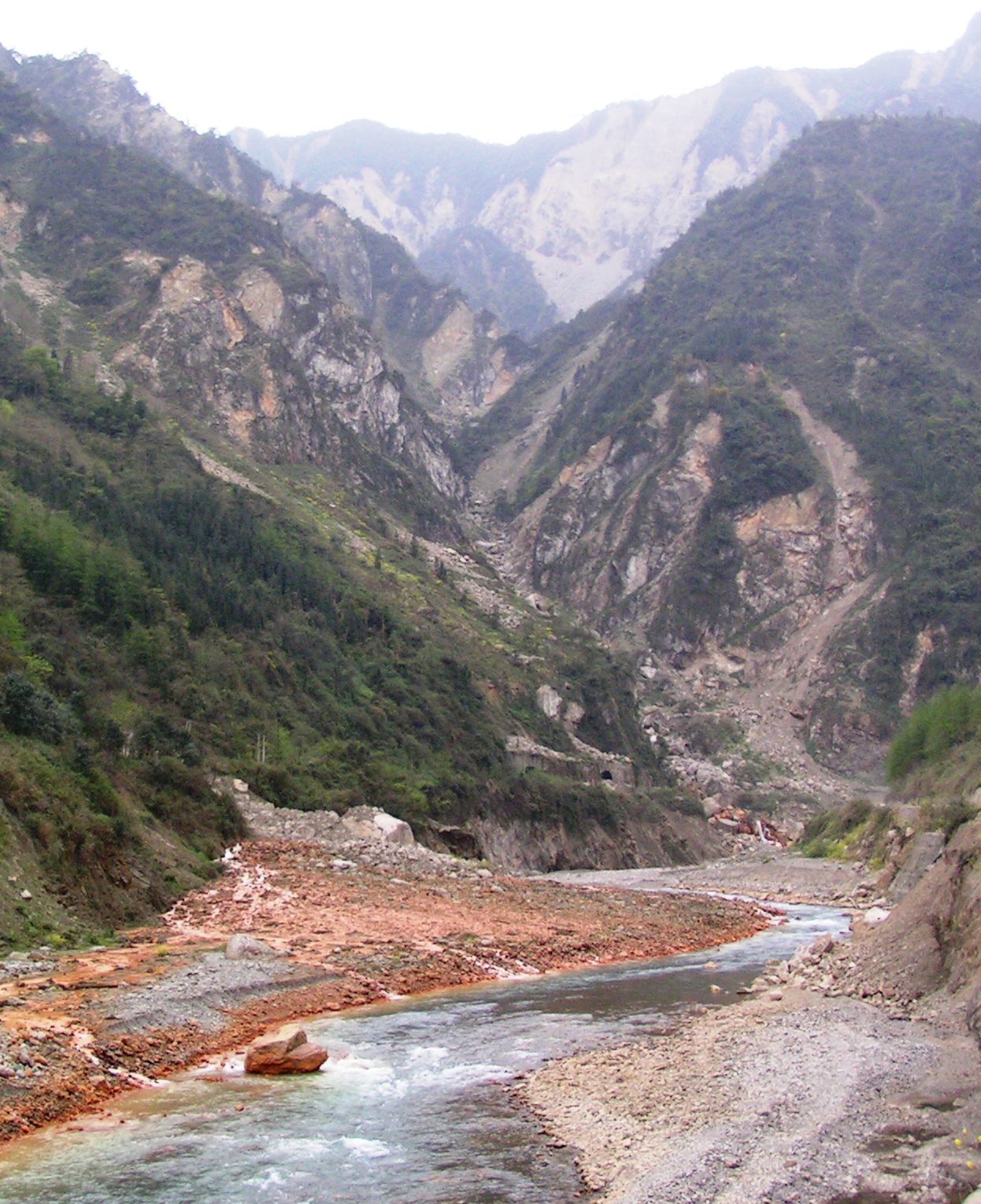
UBC Geological Engineering distinguished lecture
Last week I was fortunate to have the opportunity to deliver the annual UBC Geological Engineering distinguished lecture, entitled “Earthquake-induced landslides – lessons from Taiwan, Pakistan, China and New Zealand”. At the time I promised to make the Powerpoint file available for download, so, I have uploaded it onto Authorstream. The file can be found here and should be visible as a preview below:
..
 Dave Petley is the Vice-Chancellor of the University of Hull in the United Kingdom. His blog provides commentary and analysis of landslide events occurring worldwide, including the landslides themselves, latest research, and conferences and meetings.
Recent Comments