

3 December 2014
The Domkar Monastery landslide in Qinghai, eastern Tibet
The Domkar Monastery landslide
In mid November the ever impressive Tibet Earthquake twitter feed (@aam868) posted a number of reports about a landslide at the Domkar Monastery in Qinghai, eastern Tibet. This landslide, appears to have occurred on 2nd November 2014, is both spectacular and catastrophic. The Domkar Monastery is located at 33.01N, 97.14E:
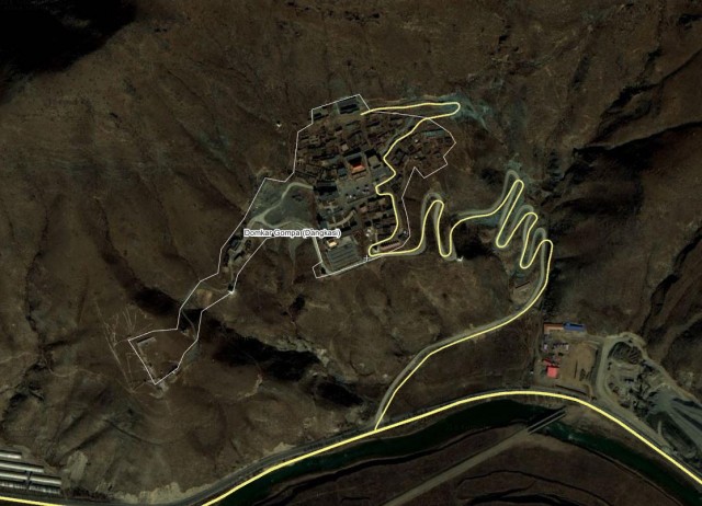
.
The site appears to have undergone a massive rotational slip with an enormous displacement across the back scar: From the Tibet Express, these are the before and after shots:
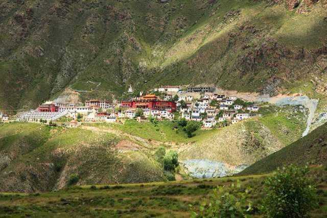
Domkar Monastery before the landslide (image from the Tibet Express)
.
And after:
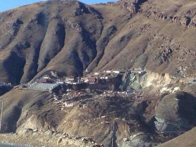
Domkar Monastery after the landslide (image from the Tibet Express)
.
Note the damage to the access road. Interestingly, this site was severely damaged by the Yushu earthquake in 2010; rebuilding had only been completed this year. In fact, if you look carefully at the before image it is clear that the back scar of the landslide had already formed, with substantial displacement have already occurred. The lateral scarp of the landslide has cut through the main temple, with major part of the building having been completely destroyed. China News has this image of the landslide, showing some detail of the damage. A translation of the text confirms that there were no injuries:
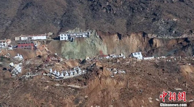
.
The material forming the landslide appears to be loess, which is prone to large-scale landslides. It would be interesting to know if there had been any construction works at the toe of the slope – often rotational landslides of this type are triggered by unloading of the foot of the slope.
1 December 2014
Landslides in the Movies Part 2: The Railway Children (1970)
The Railway Children – Landslides in the Movies Part 2
This is Part 2 in my new series on Landslides in the Movies. Part 1 is here. The 1970 movie The Railway Children, which was based on a novel of the same name by Edith Nesbit, stars a very young Jenny Agutter. Probably the most famous scene in this film occurs when a landslide blocks the railway line at a time when a train is approaching. The three children run up the line to flag down the approaching train, thus preventing a disaster. This scenario is far from impossible – indeed I have featured landslide-induced derailings of trains on many occasions on this blog, and some of them do indeed have catastrophic consequences.
The landslide scene in the film is shown in this sequence on Youtube:
http://www.youtube.com/watch?v=Vn4jeFRLv_U
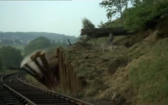
If nothing else it makes you realise how far special effects have come in the last 45 years. The movement starts as a translational slide – note how the trees remain perfectly upright as they displace – although the movement of the trees whilst the grass around them remains static is quite amusing in some ways. A really nice element is that the landslide occurs on a cut slope that clearly has an inadequate retaining structure at the toe – it looks like poor engineering by the construction crew to me. The should never have expected to retain a slope of this size with old railway sleepers. In addition, the way that the wooden posts topple onto the line suggests that they had very shallow foundations – surely a recipe for disaster:
.
It is this poor engineering that probably accounts for the collapse on a beautiful sunny day and in a dry condition (note the dust that is kicked up by the collapse at various points). The boulders on the line at this point is a nice touch, suggesting some precursory deformation.. Of course the sequencing of the failure is a little odd, in that the upslope section moves before there is much deformation in the retaining structure – there is clearly a complex process at work here.
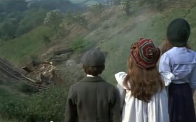
The post-failure landslide
.
I’m not sure that the film crew managed to depict the post-failure landslide scar particularly well – the deformation at the start suggests that the scar should extend right up the slope.
Finally, I think that the children need to study natural hazards at school, given that they diagnose the event as an earthquake.
30 November 2014
Landslides in Art Part 21: Harlequin
Harlequin
It has been a long time since I posted in my Landslides in Art series, so this one is well overdue. The last posting in this series was made almost a year ago. I really don’t know very much about this artist, except that she is based in Taipei in Taiwan, and uses the pseudonym Harlequin or Harlequipan. The painting in question appeared on her blog, which new seems to be defunct, four years ago. It is simply titled Landslide:

Landslide by Harlequin
.
To me this appears to depict the type of channelised flow failures that are common on the steep slopes in the Central Mountains of Taiwan, triggered both by heavy rainfall and by earthquakes, such as this one from the 1999 earthquake:
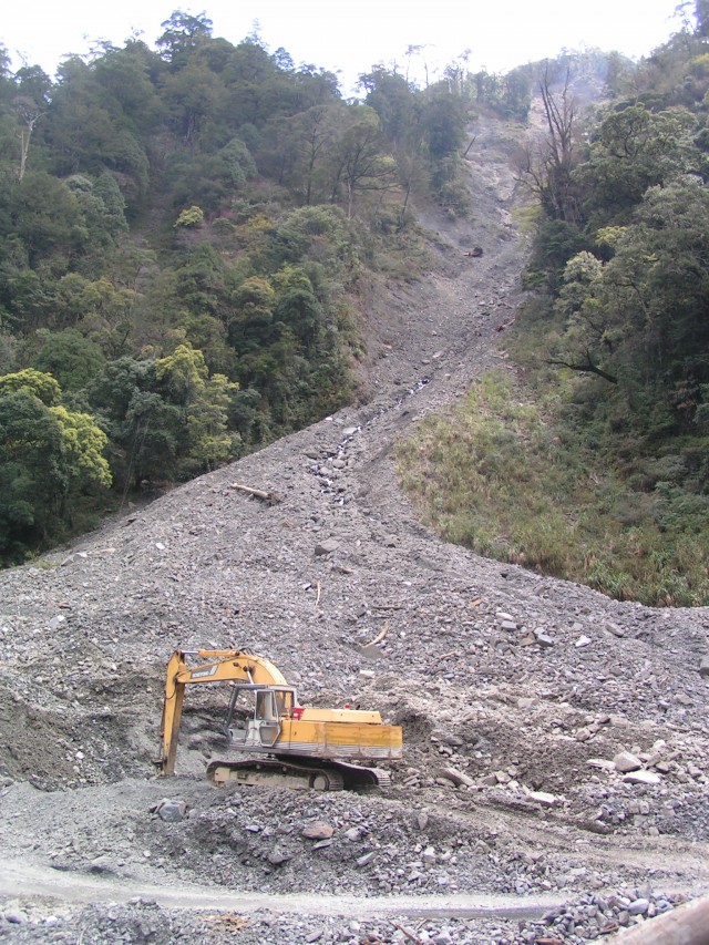
A landslide from Lishan, Taiwan
.
I would welcome suggestions for future posts in this series.
18 November 2014
Rabenstein, South Tyrol: a great new landslide video (and a quick update on the Mannen landslide)
Rabenstein, South Tirol
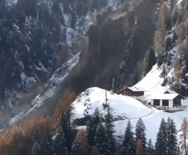
A large landslide occurred at Rabenstein in the South Tyrol northern Italy (this is the German-speaking area of northern Italy). Fortunately it was caught on video and is now available on both Liveleak and Youtube – I have embedded the Youtube version below because it is easier:
http://www.youtube.com/watch?v=XCyth3DMPGI
.
The reported volume of this latest landslide is 20,000 cubic metres. The very large amount of precursory deformation is notable, as is the very rapid fragmentation of the rock mass as the collapse developed:
.
This is not the first landslide event at this site – Liveleak also has a smaller, earlier landslide event, which I think occurred on 30th September:
.
This second video is worth watching for the movement of the enormous boulder at the foot of the slope, which was safely captured by an engineered runout zone.
An update on the Mannen Landslide in Norway
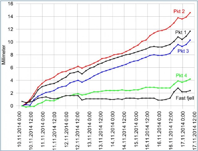
Meanwhile the Mannen landslide in Norway has now clearly entered a steady secondary creep phase of movement. The Rauma Kommune website posted an update in Norwegian two days ago, which includes this movement graph:
.
The commentary suggests that continued low temperatures and dry conditions suggest that little change in the rate of movement is expected in the days ahead.
17 November 2014
Markagunt: A truly gigantic gravity landslide (2000 cubic kilometres!)
The Markagunt gravity slide
In the current edition of the journal Geology, a paper by David Hacker, Robert Biek and Peter Rowley (Hacker et al. 2014) describes the Markagunt gravity slide in southwest Utah. This is a very exciting piece of work as it identifies for the first time a truly gigantic landslide. Whilst I like to avoid superlatives, the scale of the Markagunt landslide is remarkable:
- 90 km long
- 1700 – 2000 cubic kilometres in volume
- Surface area of over 3400 square kilometres
- Up to 200 m thick.
This is part of the area that it covers:
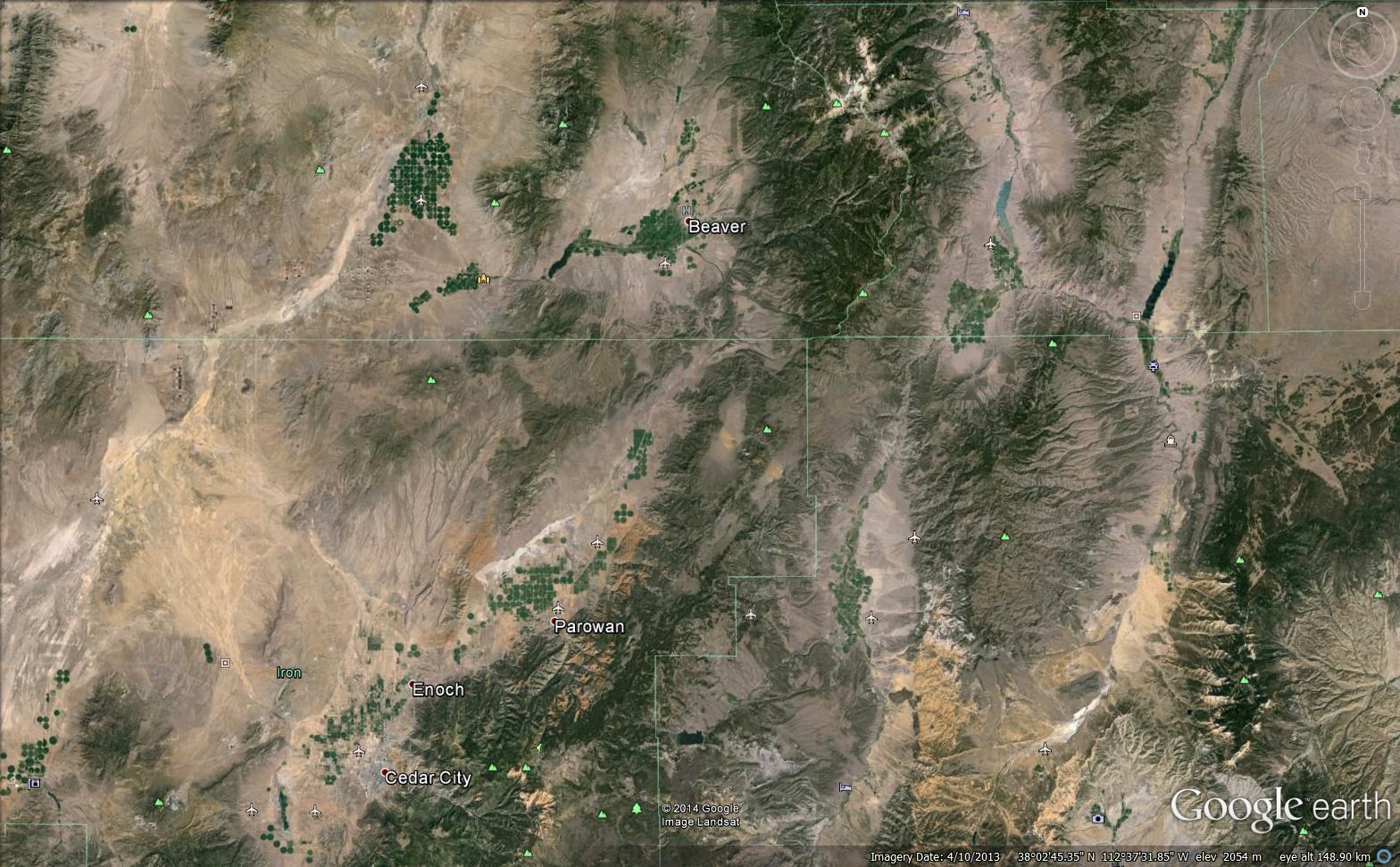
Google Earth image of part of the area covered by the Markagunt landslide
.
The landslide deposit is located in the Marysvale volcanic field in Southwest Utah in the USA. This is not the first time that these landslide deposits have been identified, but previous studies have suggested that they were formed in multiple landslide events, and have termed the deposit the Markagunt volcanic breccia. The change in Hacker et al. (2014) is that the deposit is now recognised as having originated in a single landslide that occurred about 22 million years ago. The paper demonstrates that the landslide consists of a large sheet of volcanic rock broken up by faults. The authors divide the landslide deposit into three distinct sections:
- A 58 x 42 km bedding plane segment;
- A 1-2 km wide ramp segment;
- And a 32 km long land surface segment.
The question of course is how such an enormous landslide can form. The base of the Markagunt gravity slide consists of of a clear shear surface with brecciated (i.e. intensely shattered) rocks. However movement has occurred on a shear surface that has an inclination of only a small number of degrees. The authors suggest that as the Maryvale volcanic field developed, it uplifted the Turshar Mountains, generating a slope in the surrounding rocks. At the base of what was to become the landslide is a very weak volcanic deposits known as the Brian Head formation, allowing sliding to develop.
There is only one other known landslide on this scale – the infamous and equally enormous Heart Mountain Gravity Slide. These two deposits are now the largest subaerial landslides on Earth. Both are of course in the USA; I wonder how many more there are around the world that have yet to be identified?
Reference
David B. Hacker, Robert F. Biek and Peter D. Rowley 2014. Catastrophic emplacement of the gigantic Markagunt gravity slide, southwest Utah (USA): Implications for hazards associated with sector collapse of volcanic fields. Geology 42, 943-946. DOI: 10.1130/G35896.1
12 November 2014
Mannen landslide: latest status report
Mannen landslide
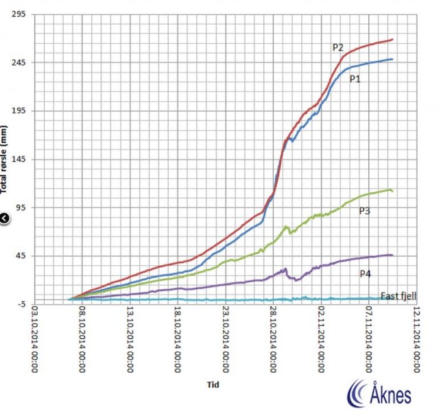
Over in Norway, the Mannen landslide continues to creep slowly – about 2 mm per day now, as the graph below shows:
.
The Rauma Kommune website has an update (in Norwegian but Google Translate does a good job). The key points that emerge are:
- The risk level has been downgraded red to yellow, but this still requires continuous evaluation of monitoring data.;
- The monitoring system has been upgraded to provide better radar systems, the installation of a geophone (that might generate some very interesting scientific data), a LIDAR (laser) monitoring system and enhanced use of weather stations to determine the water inflow to the landslide;
- The railway has reopened to freight traffic only;
- Those evacuated from the site remain out of their houses;
- A decision has been taken (wisely in my view) not to use water-bombing due to the uncertainties
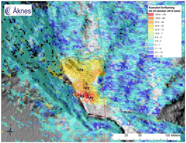
The latest update report from Aknes is also online (PDF again in Norwegian). The most interesting aspect of this report is a map showing the deformation across the hillside, with the monitoring positions marked as well. The map shows deformation over the period 6th to 29th October; I’d think this is slope radar data:
.
The very high level of deformation at the top of the slope is clearly visible, as are the smaller deformations downslope. This map helps gain an understanding of just what a large block makes up this active landslide. Given the onset of winter conditions the monitoring of the landslide and forecasting its future behaviour are becoming increasingly difficult. whilst the next obvious danger point will be the spring snow melt and thaw season, a period of warmer weather might also pose risks. Of course there is also a chance that the ongoing secondary creep will tip the landslide into a tertiary creep phase, leading to failure, so it is not possible to make any assumptions.
11 November 2014
Review of a paper: The Donghekou landslide in China
The Donghekou landslide
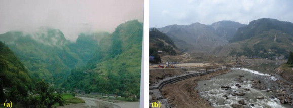
One of the largest landslides triggered in the remarkable 2008 Wenchuan earthquake in China occurred at Donghekou in Qingchuan County. This was a large slide – it has a volume of about 100 million cubic metres and it traveled over a distance of about 2 km. Four villages were buried, resulting in about 780 deaths. This landslide has been examined in detail in a paper, Wang et al. (2014) just published in Engineering Geology. This pair of images, whose provenance is somewhat unclear but which was reproduced in another paper on this landslide (Zhou et al. 2013) provides a before and after view of the landslide site:
Zhou et al. (2013)
.
The paper is interesting in a number of ways. First, it notes that the slope was known to be unstable and indeed that during heavy rainfall events the local population was frequently evacuated. Of course this was not possible when the earthquake struck. Second, the paper notes that the landslide had a very long runout distance over a near horizontal surface, which suggests very high rates of movement. Using experimental data, the authors conclude that the landslide had such a long runout because of liquefaction of the valley fill deposits during the earthquake, which provided a very low friction surface. The landslide itself was retrogressive in nature, which is unsurprising for such a large slide.
Perhaps the most interesting aspect of the landslide though is that about six months after the earthquake fumaroles appeared on the landslide mass, generating high temperature gas and a sulfurous odour. These fumaroles are still active, although less so now than in the early phases. Unsurprisingly there has been considerable speculation as to what these fumaroles represent. The authors both sampled the gases emanating from the fumaroles and measured the temperatures a metre into the vent. They found that the ground temperatures were in the range of 50 to 60 degrees Centigrade and that the gases were primarily carbon dioxide and methane, with fluid emissions being rich in potassium, sodium, magnesium and some other trace elements, From this they concluded that the cause of the fumaroles was oxidation of carbonaceous siliceous shale that had been exposed to the air and oxygen-rich water as a result of the movement of the landslide.
This is of course not without precedent – indeed back in 2008 I wrote a blog post about the strange phenomenon of burning landslides, using an example from Dorset in the UK.
References
Zhou,J-W., Cui, P. and Yang, Y.G. (2013). Dynamic process analysis for the initiation and movement of the Donghekou landslide-debris flow triggered by the Wenchuan earthquake. Journal of Asian Earth Sciences. 76, 70-84. DOI: 10.1016/j.jseaes.2013.08.007
Wang,G., Huang, R., Lourenço, S.D.N. and Kamai, T. 2014. . A large landslide triggered by the 2008 Wenchuan (M8.0) earthquake in Donghekou area: Phenomena and mechanisms. Engineering Geology. DOI: 10.1016/j.enggeo.2014.07.013
7 November 2014
A roundup of recent landslide events
1. The Mannen landslide
Unfortunately the Mannen landslide in Norway continues to creep without failing. TV2 is heroically maintaining its webcam, and the residents in the valley below remain temporarily homeless. The Mannen Direkte webpage has a new movement graph with data from 1st to 6th November:

.
The dramatic slowdown in the rate of movement appears to be associated with the arrival of much colder weather. This suggests to me that the landslide is still in a secondary creep phase, meaning that there is deep uncertainty about when the landslide might start to fail.
A fatal landslide in Switzerland
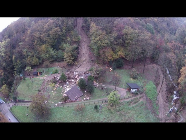
Meanwhile, in Switzerland a landslide on Wednesday night struck a house in Bombinasco in the south of the country. Judging by the image below, the landslide was not large, but unfortunately it destroyed a house, killing a 31 year old woman and her three year old daughter:
.
3. A landslide in Quebec derails a freight train, leaving a worker missing
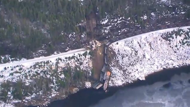
Over in Canada a train carrying iron ore was derailed yesterday close to the Moisie River, north of Sept-Iles in Quebec. The landslide appears to have been a joint-controlled rockslide, which forced the locomotives and a number of railcars into the river:
.
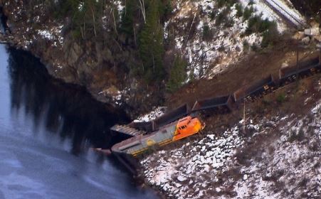
Sadly the driver is unaccounted for. The train had three locomotives, of which only one is visible in the above image. The image below suggests that at least one of the locomotives is submerged:
6 November 2014
Review of a paper: the role of earthquakes and climate change in generating landslides in Peru
Earthquakes and landslides in Peru
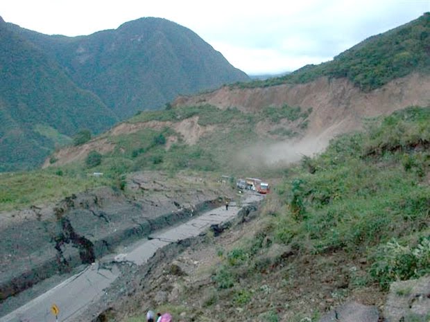
Peru is a country that has an abundance of landslides, resulting from a combination of high rates of tectonic uplift (which creates mountains that can be eroded), frequent earthquakes and regular intense rainfall events (often linked to El Nino episodes). It has been known for a while that the rate of landsliding in Peru has changed dramatically in the past, and it has been widely hypothesised that this might have been linked to periods of more intense precipitation associated with phases in which El Nino events were larger and/or more frequent. Clearly this is interesting not just from a scientific perspective but also because it might provide insights into the role if future climate change in generating landslide hazards.
.
In a paper just published in Nature Geoscience, McPhilips et al. (2014) have explored this hypothesis by examining cobbles located in the Quebrada Veladera river channel and an associated fill terrace. The have used 10Be concentrations in individual cobbles to determine erosion rates for the catchment. The modern cobbles in the river channel give an indication of the current erosion rate, which is occurring when the climate is very arid (less than 200 mm rainfall per year on average, whereas the terrace is dated from 16,000 years BP, when the climate was sufficiently wet to maintain a 60,000 square kilometre lake on the altiplano.
The results are quite surprising. In the words of the abstract:
The distribution of 10Be concentrations in terrace cobbles produced during the relatively wet climate before about 16,000 years ago is indistinguishable from the distribution in river channel cobbles produced during the drier climate of the past few thousand years. This suggests that the amount of erosion from landslides has not changed in response to climatic changes.
In other words, it does not appear to be the case that during this phase of higher rainfall in Peru the occurrence of landslides increased. This is counter-intuitive in many ways, and it is not at all clear to me as to why this should be the case. The authors hypothesise that the area might be so arid that even wet phases do not generate sufficiently high pore pressures to trigger landslides, but this does not seem to agree with what our modern day obserations . If the paper is right, then an alternative trigger must be responsible for the landslides that are recorded in the sediments in the river channels. McPhilips et al. (2014) suggest that these might have been triggered by large earthquakes. It has been hypothesised previously that in very dry environments with high uplift rates earthquakes must do most of the work to trigger landslides, whereas in equivalent wet climates rainfall may be the primary factor. This is one of the first studies to provide field data in support of this idea.
The implication of course is that a large earthquake in this area would be devastating in terms of landslides, and the 2010 earthquake event may support this idea. Given that the return period for great earthquakes in Peru is about 100 years, this is a sobering thought.
Reference
McPhilips et al. (2014) Millennial-scale record of landslides in the Andes consistent with earthquake trigger Nature Geoscience (2014) DOI: 10.1038/ngeo2278
4 November 2014
Mount Mannen rockslide – still in an accelerated creep phase of movement
The Mount Mannen rockslide
The Mount Mannen rockslide in Norway is continuing to behave in an unpredictable manner, no doubt to the intense frustration of all involved. The tv2 website (in Norwegian, though Google Translate does a good job), which has the live webcam, has produced a series of graphs showing the movement of the landslide. This one, complete up to yesterday, shows the cumulative displacement of the landslide over the last month:
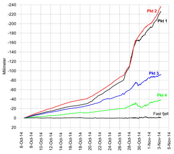
http://www.tv2.no/nyheter/mannen-direkte#
.
The lines show different parts of the monitored slope of the Mount Mannen rockslide. Points 1 and 2 in the upper part of the active slide, points 3 and 4 are in the lower section of the active block. So, it appears that the upper part of the landslide is still moving quickly (about 15 mm per day) and has now displaced about 24 cm in a month, whilst the lower part has moved about 10 cm. The difference between the two is not unusual or surprising for this type of landslide. The behaviour on about 30th October is interesting as the landslide appears to have slowed dramatically in the upper portion and actually stopped briefly lower down, before starting to move again. We see similar behaviour in lab tests that simulate creep movements, although we cannot fully explain these episodes. Whilst the movement record is quite noisy (which is unsurprising for an area that receives regular snowfall), the medium term trend is still an accelerated creep movement pattern, and my view would be that the slightly longer-term rate of creep is still increasing, with variations caused by changes in the environmental forcing (i.e. temperature and rainfall).
In other words the authorities are correct to maintain the evacuation. I remain skeptical that much can be done to speed up this natural process. Although it is frustrating, nature probably needs to be allowed to take its course.
 Dave Petley is the Vice-Chancellor of the University of Hull in the United Kingdom. His blog provides commentary and analysis of landslide events occurring worldwide, including the landslides themselves, latest research, and conferences and meetings.
Recent Comments