

20 January 2015
Zanskar River landslide: more information
Zanskar River landslide
The ever-reliable Tibet Earthquake twitter feed(@aam868) has tracked down some additional information about the valley-blocking landslide on the Zanskar River on northern India. Perhaps most usefully, it includes links to two images of the landslide, the first of which is in a report in the Outdoor Journal:
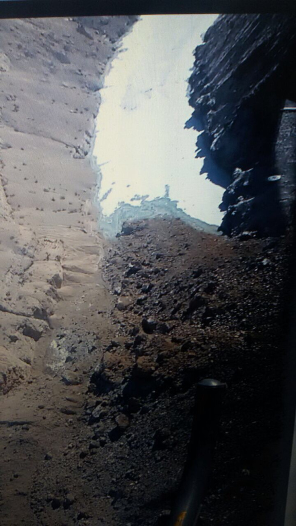
.
Whilst the second is from the White Magic twitter feed:
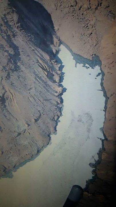
.
Unfortunately, these images are still not really good enough to be able to properly assess the hazard at this site.
19 January 2015
A new valley blocking landslide in the Zanskar valley in northern India
Zanskar valley landslide
News agencies in India are reporting that a large landslide has blocked the Phuktal River in the Zanskar Valley. The information about this landslide is a little unclear, although most reports suggest that the barrier is about 200 feet (61 m) high. It appears that a helicopter overflight has been undertaken, from which DNA have published this not very high quality, but still interesting, image:
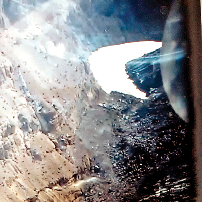
.
If this is indeed the landslide then a large and already frozen lake appears to have started to develop. The landslide itself is indeed substantial. The material on the left side looks to be quite fine-grained.
Presumably at this time of year the rate of flow along the river is comparatively low, but the landslide undoubtedly poses a significant threat. Reports suggest that four villages are being evacuated and that the Chadar Trek, a 150 km ice hike, has been closed. Kashmir Life suggests that the landslide occurred on 31st December and that the lake is now 5 km long.
Based on the information that is available in the news reports, this is the most likely stretch of river affected by the landslide:
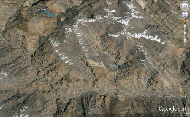
Google Earth
.
This image suggests that it will be extremely difficult to move sufficient resources to the site to manage the hazard.
6 January 2015
The Scorciavacche Viaduct in Sicily: an earthworks failure that has become a national scandal
The Scorciavacche Viaduct in Sicily
In Italy there is something of a scandal developing around the newly completed Scorciavacche Viaduct, a new (very impressive) elevated highway not far from Palermo. The road opened a couple of days before Christmas, but has now had to be closed again because of the collapse of a section built on an embankment. The story has attracted considerable attention from the international media, who are generally describing the problem as “subsidence”.
The best images that I can find of the site are on the Repubblica website (text in Italian), which has an excellent portfolio. This includes a good picture of the roadway – it’s not hard to see why the highway has been closed:
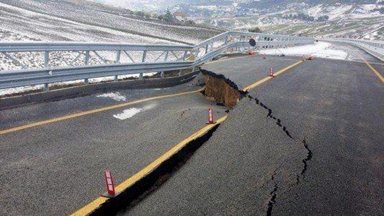
.
The problem appears to be the failure of a set of remarkably steep earthworks alongside one of the bridge abutments (the abutment itself seems to be intact):
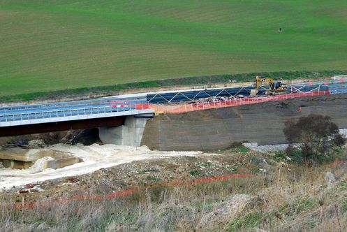
.
A closer view of the problem gives a better indication of the problem:
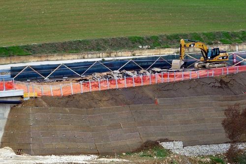
.
The failure seems to have affected quite long section of the embankment:

.
This is clearly an earthworks failure – i.e. a landslide in the embankment. I am not really familiar with the construction technique here – others ate probably better placed to comment. The embankment seems to be founded on gabians. Above this is some sort of slope protection covering a steep earth bank. Close to the abutment (see the second picture) this might be soil nailed (comments – experts have subsequently suggested that these are not likely to be soil nails, it is not clear what these objects are), but this doesn’t seem to be the case for most of the embankment. The major failure seems to be in the first section without the soil nails, which is showing distress directly above the base of the embankment. Further to the right the failure is more complex and difficult to understand.
This case is now subject to formal investigation by an Italian magistrate, so hopefully the cause will become apparent soon. It will be very interesting to see what emerges. In the meantime, I’d welcome comments from those who know about embankments.
5 January 2015
Erlang village, Guizhou: a deadly rockslide in China
Erlang Village, Xishui County, Guizhou
The Chinese media is reporting that a large rockslide occurred at Erlang Village in Xishui County within Guizhou Province in SW China. The landslide reportedly occurred at 3:40 pm on Sunday, covering a major highway that links Chengdu and Zunyi City in Guizhou. It is known that at least 3 people have been killed, but search efforts continue in the fear that there may be further vehicles buried beneath the debris.
The best overview of the landslide, which reportedly has a volume of 80,000 cubic metres, that I have found to date is on the Now News website (in Chinese):
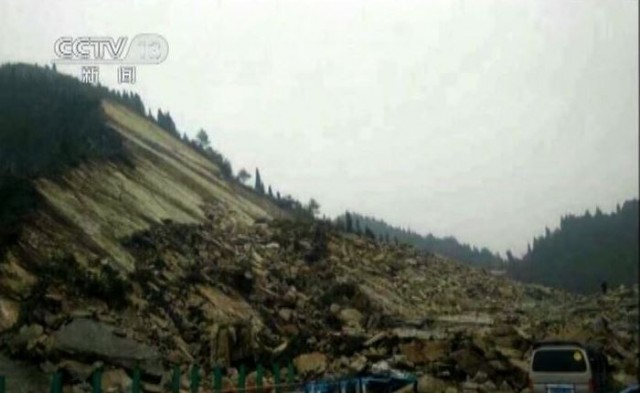
.
Whilst the image is not particularly good, this looks to be about as good an example of a rockslide on a pre-existing discontinuity (bedding plane?) as you are ever likely to see.
CRI English has some rather better images of the aftermath:
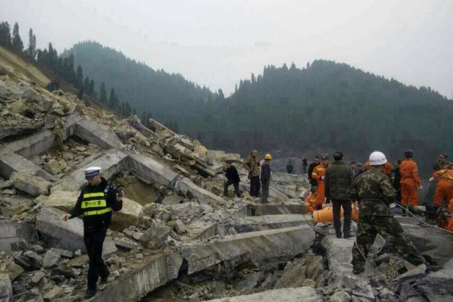
.
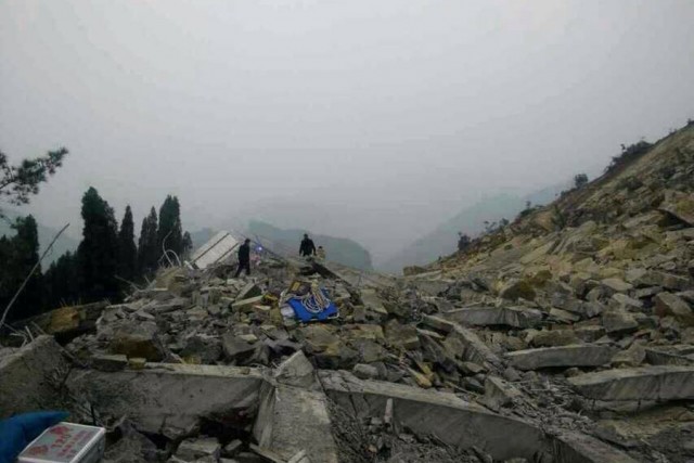
.
The difficulty of recovering the potentially-buried victims is easy to appreciate. My suspicion is that the concrete structures seen in the images are the grid works associated with rockbolts or ground anchors, in place to stabilise the slope. If so then these works have not been successful, so it would be interesting to know why this slope failure has occurred.
19 December 2014
My latest paper: Patterns of movement at the Ventnor landslide on the Isle of Wight
The Ventnor landslide
One of the most interesting landslides in the UK lies under the town of Ventnor, which is located on the southern side of the Isle of Wight in southern England. This is a large, slow moving landslide that nonetheless causes considerable damage, particularly in periods of accelerated movement. Over quite a long period, the Isle of Wight Council worked with Halcrow (now CH2M HILL) to understand the landslide by monitoring its movement patterns. In recent years I have worked with a part time PhD student, Jon Carey (who is now at GNS Science in New Zealand), and Roger Moore at Halcrow, to understand the relationships between the movement of the landslide and pore water pressures. That work is a part of Jon’s PhD thesis (which is available online), and has just been published in the journal Landslides (Carey et al. 2014).
Perhaps the most interesting aspect of this landslide is a large graben structure that is opening up at the crest of the landslide. This is one of the figures from the paper, showing a geomorphological map of the landslide together with, bottom left, the graben structure:
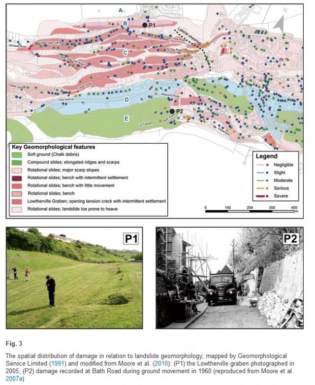
Figure 3 from Carey et al. (2015). Copyright Springer
.
In the paper we examined some very detailed monitoring data that was collected in a study led by our co-author, Roger Moore, between 1998 and 2002. During this time, Halcrow monitored the pore water pressure at depth using piezometers located in deep boreholes and the opening of the graben using crackmeters (to measure horizontal movements) and settlement cells (to measure vertical movements). We found that the movement of landslide can be divided into two key components. In the background is long-term creep of the landslide, at rates of about 5 to 10 mm per year, regardless of the groundwater conditions. This indicates that the landslide is in a condition of marginal stability / instability. However, when the groundwater level rises due to periods of heavy rainfall the landslide moves more rapidly – up to about 35 mm per year – but in a complex manner. This is captured in the diagram below, which is part of Fig. 6 from the paper:
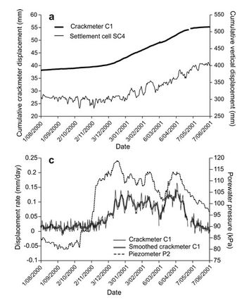
Part of Fig 6 from Carey et al. (2015). Copyright Springer
.
The upper panel of the diagram shows the movement of the landslide as indicated by extension of the graben sides and subsidence of the graben floor. The lower panel shows the same data for the crackmeter, but expressed as a displacement rate, and the measured groundwater level. It is clear that as the groundwater level increases the landslide movement rate goes up, and vice versa. However, across the entire dataset we found that the relationship between the pore water pressure and movement rate was not simple, and in particular that sometimes the movement rate remained elevated even as pore water pressures reduced.
At Ventnor there has long been discussion of the likelihood that the landslide might transition into a more rapid movement event. Our data suggests that because the landslide is occurring on a very well-developed basal shear plane, and because the toe of the landslide is buttressed by large landslide blocks, this is unlikely without some fundamental shift in material behaviour.
Reference:
Carey, J.M., Moore, R. and Petley, D.N. 2014. Patterns of movement in the Ventnor landslide complex, Isle of Wight, southern England. Landslides. doi: http://dx.doi.org/10.1007/s10346-014-0538-1
18 December 2014
Amazing but watch with caution: camera phone footage of the deadly Banjarnegara district landslide in Indonesia
Camera phone footage of the deadly Banjarnegara district landslide in Indonesia
Hidden in the depths of Youtube is a quite amazing video, uploaded on 13th December, of the Banjarnegara district landslide in Central Java, Indonesia. The current known loss of life from this event is 83 people, 25 people remain missing. I cannot guarantee the authenticity of this video, although I’ve certainly not seen it before. I must caution you to watch with care – whilst there are no directly horrific scenes, the sense of utter chaos and panic is disturbing – really disturbing. This is far from easy viewing. The video can be found here, and as usual I have embedded it below:
http://www.youtube.com/watch?v=vwaHn-_tM1k
.
A key question of course is whether this is genuine – well first it is clearly a landslide disaster. This is the best screenshot that I have found from the video:
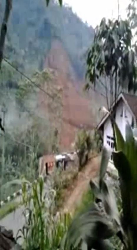
.
This is from 38 seconds into the video, when a wave of material (very clearly a flow) can be seen. A comparison with this image (via Voice of America), from a different angle (and note this is very foreshortened), suggests to me that it probably is the same landslide, but this needs confirmation:
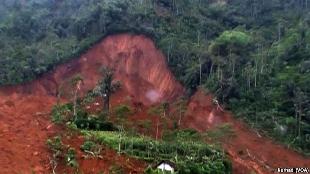
Source: Voice of America
.
The video stops half way through – the text thereafter says “thank you for watching; thanks for his visit”, or something similar.
The video does capture the utter chaos of the situation during a catastrophic landslide, and should be a spur to all of us involved in landslide work. The losses from this landslide include 20 school children, 11 more children aged less than 10 years old and two elementary school teachers.
17 December 2014
Landslides from the 2010 Mw=7.2 earthquake in the Sierra Cucapah, Mexico
Sierra Cucapah earthquake
On 4th April 2010 a Mw=7.1 earthquake struck the Sierra Cucapah range of northern Mexico. I blogged about that earthquake at the time (though the blog post didn’t survive the migration to the AGU website so well – it works a bit better on my original blog site) because the amazing dust clouds generated by the landslides triggered by the earthquake were captured on a mobile phone camera, and were subsequently uploaded to youtube:
At the time I had a post-doctoral researcher, Dr John Barlow, working with me at Durham. He and I, together with other colleagues, became intrigued by the landslides triggered by this earthquake for a number of reasons. First, we wanted to know just how many slides would generate this sort of effect. Second, there is very little data on landslide triggering in an earthquake in an arid regime. And third, it has been hypothsised that in an arid, seismically-active area most of the erosion might be generated by earthquake-induced landslides. So we applied to the Natural Environment Research Council (NERC) in the UK, and obtained a grant to study these landslides.
This is a hazardous area, and we were strongly advised that it would be risky to spend much time in the mountains (these are human rather than natural hazards of course), so we undertook the research using remote sensing. The results (Barlow et al. 2014) have just been published in a paper in the journal Geomorphology. In the paper we calculated the volume of material that was moved into the mountain chain by the earthquake. For a thrust-type of event, this can be substantial as the mountains can be uplifted by the movement of the fault. However, in the case of the Mexico earthquake this volume would be expected to be quite small because most of the predominantly strike-slip movement of the fault. In fact, in this case we found that there was more subsidence than uplift – i.e. the net effect of the earthquake was to reduce the mountain volume.
We also mapped the landslides triggered by the earthquake. Despite the appearance from the video, there was not very widespread landsliding in the mountains – we only identified 452 landslides in total. However, we can use this to estimate the total volume of soil and rock released by landslides, which comes out at about 2.6 million cubic metres, again not a big total.
We also looked at the controls on the landslides triggered in the earthquake. We found a very strong control from slope gradient – i.e. steep slopes were much more likely to fail – and from peak ground acceleration (i.e. those slopes that had been shaken most intensely were most likely to collapse). So, if you were living on a steep slope close to the fault (where the shaking is most intense) you were at a high level of risk. But interestingly, we also found that there was a strong influence exerted by slope orientation. In particular, those slopes orientated perpendicular to the fault were four times more likely to fail than those orientated parallel to the fault. The reasons for this are not clear at present.
From the work that we’ve undertaken we have been able to generate graph of the occurrence of landslides in relation to distance from the fault in the mountains:
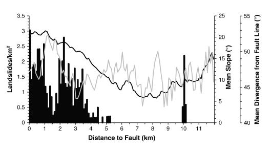
The relationship between landslide occurrence and distance from the fault, from Barlow et al. (2014)
.
The bars show the number of landslides per square kilometre, which is at a peak alongside the fault and then declines with distance. The black line shows average slope angle, which also declines away from the fault. The relationship between the landslides and the distance from the fault is generally quite simple, but at about 1.5 km from the fault the occurrence of landslides notably declines. The cause is valley orientation – this is a section of the mountains in which the valleys are orientated perpendicular to the fault, such that the slopes are parallel, as shown by the grey line on the graph. Thus landslide occurrence was much lower in this zone.
So, in conclusion, the youtube video was the inspiration to undertake a really interesting study of the landslides triggered by this significant earthquake in Mexico. As a result we now understand landslides triggered by earthquakes a little bit better.
Reference
Barlow, J., Barisin, I., Rosser, N., Petley, D., Densmore, A. and Wright, T. 2014. Seismically-induced mass movements and volumetric fluxes resulting from the 2010 Mw = 7.2 earthquake in the Sierra Cucapah, Mexico, Geomorphology, Available online 24 November 2014, http://dx.doi.org/10.1016/j.geomorph.2014.11.012.
16 December 2014
Oso: The SR 530 Landslide Commission report
Oso: The SR 530 Landslide Commission report
Yesterday, the Oso / SR 530 Landslide Commission released its final report – it is available online as a PDF. It its a very interesting document, carefully crafted and sensible in its recommendations. I would recommend that anyone interested in landslide, or indeed other geophysical, disasters reads the report as its findings are almost universally applicable. It is notable that the commission notes that there were many successes in the response, but that inevitably not everything went as smoothly as it could have done. Some aspects are almost bizarre – for example, the commission notes that:
On March 23, 2014, the second day following the landslide, Chief Willy Harper, District 25 (Oso), made a request to Chief Eric Andrews, Northwest Regional Coordinator for the Washington State Fire Defense Board, for a mobilization of state resources. Chief Andrews assessed the situation per state mobilization guidelines and made a formal request to the Washington State Patrol (WSP) for state fire service mobilization (all-hazards or state mobilization) under RCW 43.43.960 – -.964. This request was denied by WSP due to their legal counsel’s interpretation that state fire service mobilization resources and funding is available only for fire disasters.
Not surprisingly the commission recommends that this strange anomaly is put right.
However, in the context of this blog the most interesting aspects pertain to the landslide hazard and risk elements. Here the Commission makes a three key recommendations (amongst many others):
1. Support a Statewide Landslide Hazard and Risk Mapping Program
The Commission recommends the Legislature significantly expand data collection and landslide mapping efforts, which will provide the foundation for sound public and private land-use planning and decision-making.
The report provides more detail about how this should be undertaken, in particular with the use of lidar data. It is also suggests prioritization of transportation corridors, residential areas, urban growth areas, emergency evacuation routes and some forest lands. The work should be undertaken by the State Geological Survey, be subject to peer review and be overseen by a technical advisory group. The Commission illustrates the structure of this programme with the following diagram:

SR 530 Landslide Commission vision for landslide hazard management
.
It is hard to disagree with this recommendation, and indeed it is reported that the Governor has requested a budget of $36 million for “improved mapping and other landslide mitigation measures”. Whether this budget is granted is a different matter of course. My only criticism of this recommendation is in terms of the use of the information. Hazard maps are only useful if there is clarity in how and when they are to be used, and by whom. In particular it is perhaps slightly surprising that there is no mention of risk assessment or mapping, but perhaps this is considered to be a step too far at this point.
.
2. Establish a Geologic Hazards Resilience Institute
The Commission recommends the Governor explore the creation of a geologic hazards resilience institute to address education, outreach, and research needs, professional practice guidelines, and other geologic issues impacting Washington communities.
In my view this is the most interesting recommendation, and the one that could have the greatest long term impact. The vision is for an institute that provides support by:
-
Assisting tribal, state, and local governments to establish programs and staffing to address local geologic hazards.
-
Providing accurate information on geologic hazards and risks relevant to land use planners as well as to the general public.
-
Identifying needs and providing training for geohazard specialists; for example, ICS training, and other training that assures successful emergency response.
-
Establishing public information response protocol for emergencies.Enhancing public education and awareness programs and partners.
-
Identifying long-term research and education/outreach funding partners.Conducting educational, outreach, and research activities.
If such an institute were to be established then Washington State could become a world leader in hazard management, a very exciting prospect.
.
3. Conduct Landslide Investigations
The Commission recommends the Department of Natural Resources (DNR) Division of Geology and Earth Sciences, Washington State Department of Transportation (WSDOT), Snohomish County, and the US Geological Survey (USGS) conduct landslide investigations to characterize the mechanisms that activated the landslide and to understand the stability of the landslide mass.
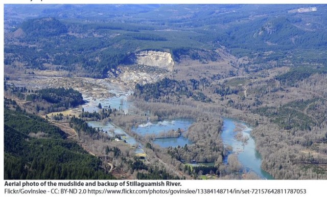
Oso landslide overview, from the SR 530 Landslide Commission Report
.
I cannot over-emphasize just how important this is. Undertaking a proper, detailed assessment of this landslide, and others as they occur, using a combination of detailed mapping, drilling, monitoring, lab testing and modelling is vital if we are to understand where such hazards will occur in the future. Opinion remains divided as to whether the incredibly destructive, fast and long runout of the landslide could have been foreseen (I remain convinced that it could have been), but we still need to understand properly the mechanisms that allowed this behaviour to occur. Proper forensic investigations are the key. Interestingly, this will be discussed in detail at the AGU Fall Meeting on Friday – I wish I could be there for both the poster session and presentations).
So overall, I think that this is an excellent report that deserves to be both read widely and to be implemented properly. It will be interesting to see what happens to the budget requests over the next few months.
15 December 2014
The Banjarnegara landslide in Central Java, Indonesia: 32 dead, 76 missing
The Banjarnegara landslide
Late on Friday night a large and apparently very rapid landslide was triggered by heavy rainfall at Banjarnegara in Central Java, Indonesia. Latest reports suggest that 32 bodies have been recovered to date, with a further 76 people thought to be missing. The likelihood of their having survived the landslide is low; one can only hope that, as is often the case, it turns out that at least some of those reported missing were elsewhere at the time of the landslide. A further 15 people were injured, 11 of those seriously.
This image, from the Straits Times, shows the landslide site from close to the toe:
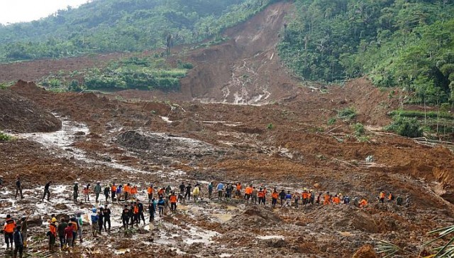
Banjarnegara landslide, via the Straits Times
.
As well as being a tragedy, this is an interesting landslide for two reasons. First, the slide appears to have been a very mobile earthflow – in fact there appears to be two lobes with an untouched area between. Second, the landslide appears to be surprisingly deep-seated in the source area judging by the size of the lateral scarp on the left side of the lower part of the source area. It seems that this deep-seated nature created a very large mobile mass that overran the village.
The source area of the landslide is quite well illustrated in this AP image via CTV:
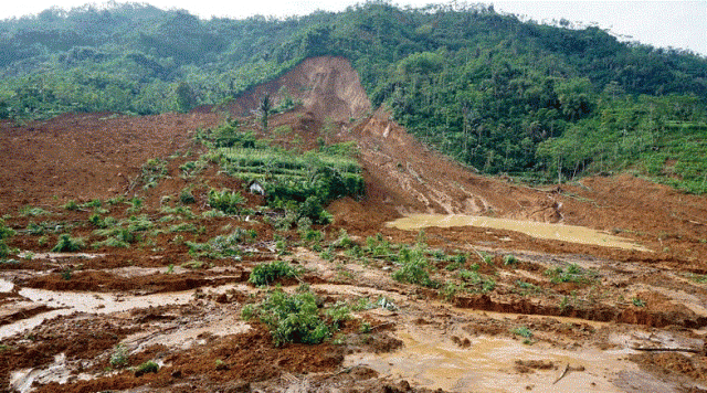
Banjarnegara landslide (AP via CTV)
.
As far as I can see the slide has occurred in deeply weathered residual soil, with no evidence of bedrock, or a bedrock – regolith contact, in any of the images that I’ve seen. I wonder if this was a static liquefaction type process to generate the exceptional mobility. An alternative might be an undrained loading process generated by an initial failure near to the crown of the landslide, which would also explain the mobility, although the depth of the failure surface might be harder to explain.
Whatever the cause, this is a landslide that deserves detailed analysis. Java is a global hotspot for landslide deaths because of the toxic combination of steep slopes, volcanic soils, heavy rainfall and lots of people. There is an urgent need to understand better the mechanics of these large and immensely damaging landslides there.
4 December 2014
The Domkar Monastery landslide: the (non-)evolution of a failure
Domkar Monastery
Yesterday I highlighted the very large Domkar Monastery landslide in Tibet, which failed in a somewhat spectacular manner last month. I have managed to track down a good image of the slope that failed, from the Tibetan Trekking website:
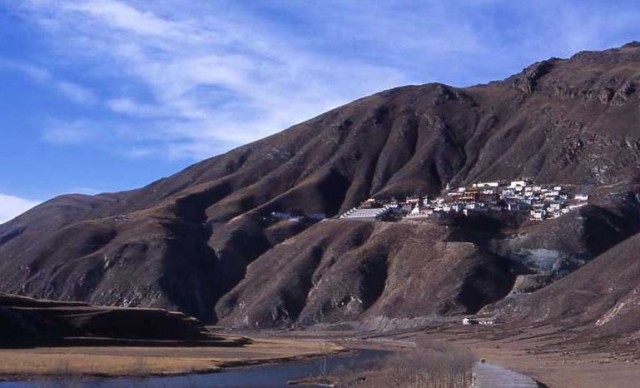
From Tibetan Trekking
.
It is not clear to me whether this mass is loess or an old landslide body – I am still tending towards the former, but it could be the latter. The failed body has deeply incised drainage lines on each side, but little sign of erosion or excavation at the toe.
It is quite interesting to look at the Google Earth archive imagery of the site, taken from a perspective view. This is November 2007:
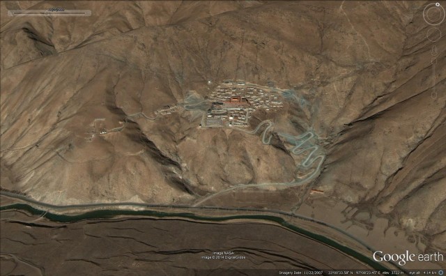
November 2007 from Google Earth
.
This is May 2009 (in black and white):
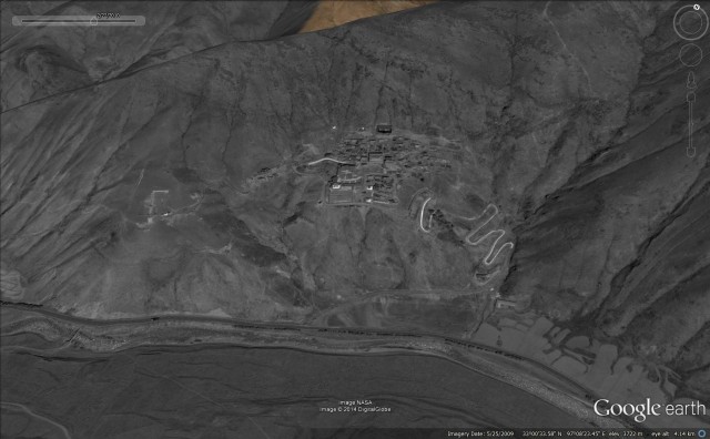
May 2009 from Google Earth
This is November 2010, which post-dates the April 2010 Yushu earthquake that affected this area and damaged the monastery:
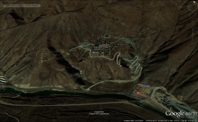
November 2010 from Google Earth
.
The most obvious change is the development of works beside the road in the bottom right hand corner of the image – I wonder what this is? But the remarkable thing is that there is really no sign in these three images of the development of the landslide except perhaps that the rear scarp formed along the line of the track at the rear of the settlement. Even after the 2010 earthquake the landslide does not seem to have progressed, although it would be interesting to see an image from earlier this year. But from these images there is little sign that an incipient collapse was developing. I suspect that this supports the notion that this is a loess failure – loess can be a collapsible material, which means that it can be subject to rather spectacular landslides.
 Dave Petley is the Vice-Chancellor of the University of Hull in the United Kingdom. His blog provides commentary and analysis of landslide events occurring worldwide, including the landslides themselves, latest research, and conferences and meetings.
Recent Comments