

4 March 2015
Chitral and Humla – two new valley-blocking landslides in the high mountains of South Asia?
Chitral landslide
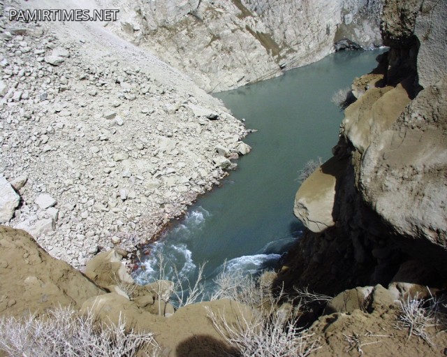
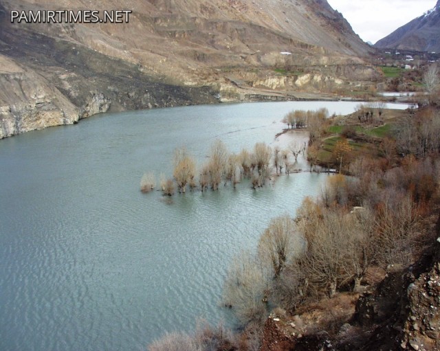
The last few days have seen unusually heavy rainfall across parts of the Himalayas and associated mountain ranges, resulting in reports of two valley-blocking landslides. The first occurred in the Reshun Valley of Chitral in northern Pakistan, and is very well reported in the Pamir Times, who have included the following images (amongst others):-
.
.
But this is a really odd one as the lake is quite large already, and the dam appears to have water flow over the top. I wonder therefore when this happened. Nonetheless, the volume of water trapped behind the blockage is substantial, so at least on the face of it there appears to be a substantial risk here. This shows the approximate location of the Reshun Valley, although the position of the landslide itself is not clear:

Google Earth
.
Humla landslide
Meanwhile in Nepal there are reports of another valley-blocking landslide, this time in Humla in the west of the country. There is much less clarity as to the situation here. Republica carried the story yesterday, including some river gauging station data. Note though that as this station is a long way downstream it is not likely that the gauging station would show a signal of the landslide. But other reports suggest that the potential landslide is as yet unidentified, and that the main concern is a dramatic fall in the river level, which could be due to a variety of reasons:
Thousands of people living in the downstream villages of Karnali River Basin were put on high alert on Tuesday morning after the water volume in one of the two tributaries of the country’s longest river dropped significantly, raising fears of possible damming upstream.
Locals along with authorities in Humla district rang alarm bells after Limi Khola, which flows into the Karnali, recorded a dramatic 80 percent drop in water levels since Tuesday morning. Limi and Muchu rivers feed the Karnali.
“We have suspected damming of the river in the high altitude region along the Nepal-China border after the water level dropped significantly in the rivers flowing in Humla. However, we are yet to ascertain whether the river is blocked due to an avalanche or has frozen,” said Keshab Adhikari, deputy inspector general of police in the mid-western region, who is updating the situation in Humla.
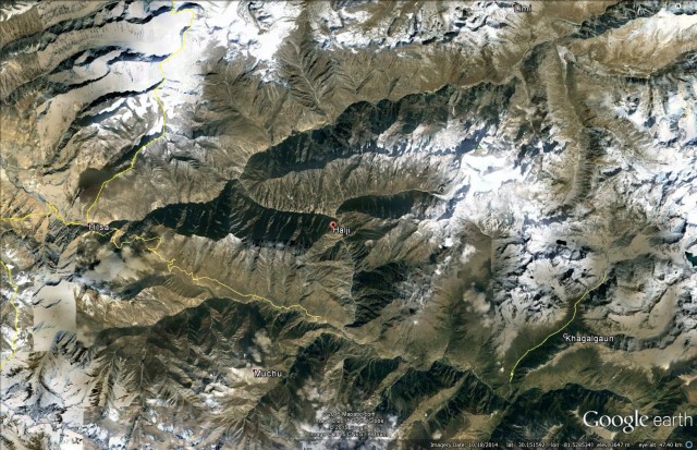
The authorities are of course right to be very cautious as the water is being stopped by something, and will inevitably be released sooner or later. There clearly is an urgent need to find out what is going on upstream as soon as possible. I believe that this is the Limi Khola, the valley affected by the landslide:-
Google Earth
.
There is a nice description of the valley on this trekking website. The good news is that the catchment of the river looks to be very small, suggesting that the rate of inflow behind the blockage should be slow.
Of course the valley-blocking landslide in Zanskar in northern India is also unresolved so we may now be in a situation of having two or three serious landslide dams simultaneously.
2 March 2015
Gazost: an impressive landslide in the Hautes-Pyrenees
Gazost
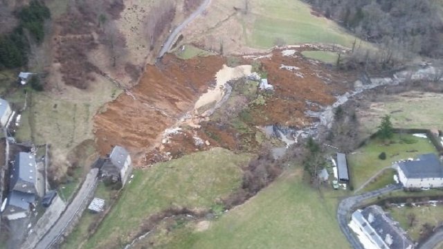
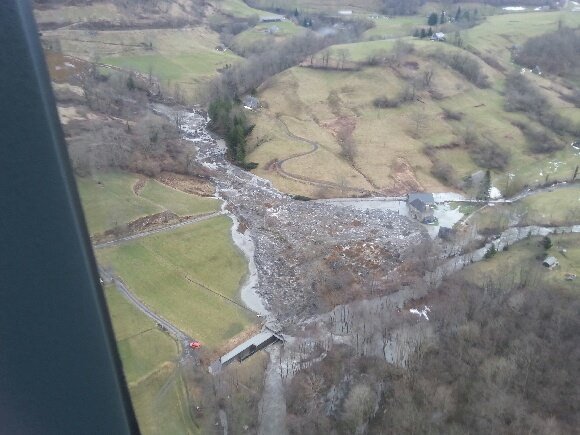
Gazost is a tiny village located high in the Hautes-Pyrenees region of France (43.031N, 0.007E if you want to find it on Google Earth). On Friday afternoon a reasonably large and quite mobile landslide removed 150 m of the only access road to the village, leaving the 20 or so inhabitants stranded. Reports suggest that the landslide occurred after a period of heavy snow in February and then rainfall more recently. France-3 has a nice gallery of images and a video of the site. This image provides a nice overview of the landslide:
Courtesy of France-3
.
This is quite an interesting landslide in that the debris appears to have been quite mobile. France-3 also has this image of the lower part of the track of the landslide:
Courtesy of France-3
.
The upper part of the landslide appears to be rotational, with a reasonably large displaced and back-tilted block:
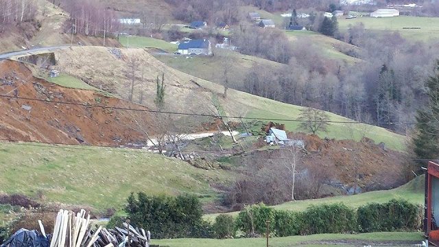
Image courtesy of France-3
.
Whilst the lower part seems to have been a mobile flow, judging by the materials at the toe:
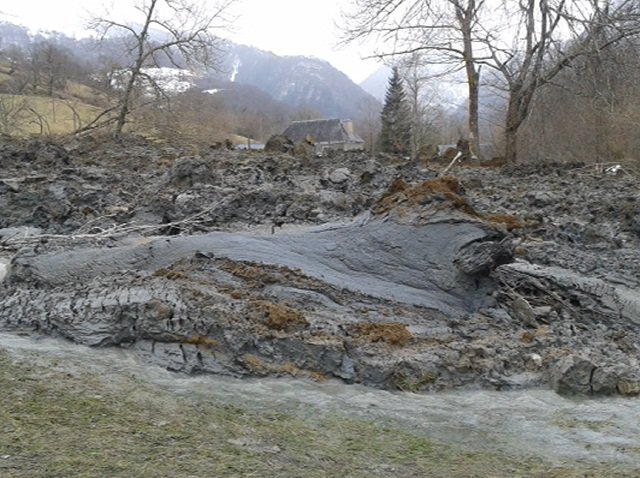
Image courtesy of France-3
27 February 2015
George Monbiot and the Harbury landslide
George Monbiot
George Monbiot is a renowned writer and commentator, primarily on environmental and social justice issues, who pens a regular article in the UK newspaper The Guardian. I admire his work greatly – The Guardian is my newspaper of choice – primarily because he has an ability to see through clarity through complex issues. Interestingly, earlier this week he wrote an article focused primarily on the Harbury landslide, entitled “Our government’s big green idea: let’s subsidise natural disasters“. The point of the article is good and sound – he is making the argument that poor slope management in the uplands of the UK is increasing the occurrence of land degradation and landslides. I have no issue with this – indeed I welcome the observation. Upland catchments in the UK should be managed much more proactively to mitigate erosion, landslides and downstream flooding, rather than to the benefit of a small number of wealthy land owners. This will become more acute as the climate changes over the next few decades.
But, George Monbiot’s linkage of this issue to the Harbury landslide looks to be wide of the mark. He notes that in the years prior to the landslide Network Rail cleared the embankments of vegetation, most notably the larger trees. George Monbiot links this to the increase in landslides along the line:
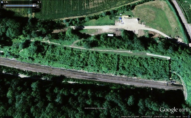
“The Harbury cutting is one of the deepest and steepest in the UK. The satellite photographs show that in 2006 the slope was heavily forested. The next image, captured in 2010, reveals that the trees had been removed and it had been scraped from top to bottom. By 2012, when the most recent Google Earth image was taken, it remained bare and grey.
“Network Rail, which carried out this work in 2008, says it did so to protect the track. But grubbing out the trees, leaving the soil bare and scouring it vertically, without at least greatly lengthening the slope to reduce its angle, looks to me like a spectacular act of folly.”
And indeed George Monbiot is correct that Google Earth images do show the removal of vegetation from the slope during this period. This is the Google earth image from 2006:
Google Earth
.
And this is the 2012 image:
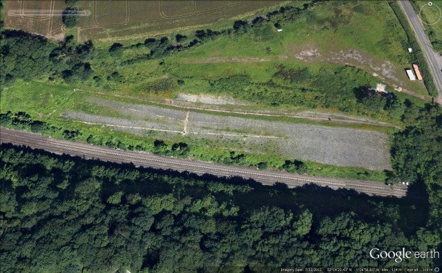
Google Earth
.
But look carefully at the images and you will see that this is much more complex than simple tree removal. It appears to me that the slope has been deliberately reprofiled, with the top layers having been removed, presumably to increase stability. In addition, it is very clear that drains have been installed. So this is self-evidently not a case of simple removal of trees, but rather a concerted effort to improve the stability of the slope.
And incidentally, it is quite reasonable and indeed sensible for Network Rail to remove trees from embankments. In the UK the embankments were frequently constructed well over a century ago. Stability in these cuttings is dependent on the drainage system, which is sophisticated (the Victorians were very good engineers) but vulnerable to disturbance. Large trees damage the drains, so it is sensible to remove them before this happens. Broken drains focus water at particular points, greatly increasing the likelihood of failure. And of course large trees can also fall onto the line, which represents a hazard in its own right.
And then of course we should take a look at the 2015 landslide. On Youtube there is a very nice video of the landslide taken from a drone:
.
What is clear from this video is that the landslide was very deep-seated – indeed, it was far too deep to have been affected in any significant way by the presence or absence of trees. So, the suggestion that this landslide was the result of removal of the vegetation is not correct, and is somewhat unfair on Network Rail, who face a very difficult challenge in maintaining this infrastructure at a time of falling budgets.
However, the more general point that George Monbiot makes about better management of the countryside in the UK is spot on.
23 February 2015
Fauquier Golf Course – the evolution of a landslide
Fauquier Golf Course
The interesting Fauquier Golf Course landslide, about which I wrote over the weekend, does not appear to be a one-off event, although the most recent movement may well be far more damaging and significant than early events. This Google Earth image is dated January 2005:
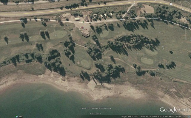
Google Earth
.
Note the linear features running sub-parallel to the shoreline just below the clubhouse. These appear to me to be tension cracks and rear scarps. The other (less good) Google Earth image is from April 2009. Take a look at these features in this image:
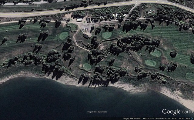
Google Earth
.
The low sun angle does exaggerate the effect, but it is clear that four years on the landslide had developed substantially. The tension cracks and rear scarps below the clubhouse had become larger and more pronounced, and they had extended down towards the shoreline, especially on the right hand side. The landslide block is very clearly delineated.
Some of the Panoromio photographs give the game away. This one, by Kuschk, is entitled “Hill slumping on hole no. 4, Fauquier & District Golf Club”. It was taken in June 2010, and does very clearly show very large, fresh scarps:
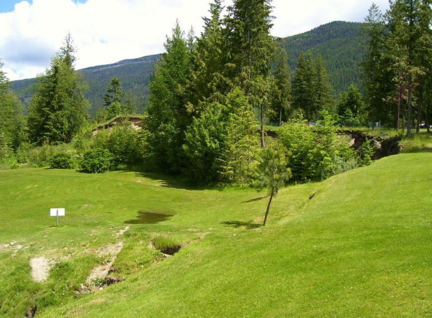
“Hill slumping on hole no. 4, Fauquier and District Golf Club” by Kuschk via Panoramio
.
Whilst this one, by the same person, shows one of the tension cracks and scarps that has extended across the fairway:
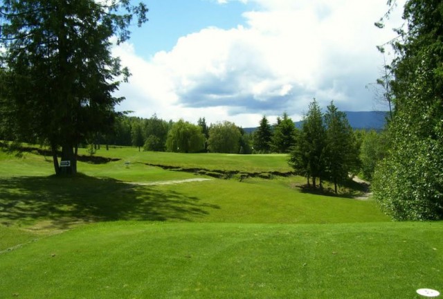
“Hole no. 4, Fauquier and District Golf Club” by kuschk via Panoramio
.
As is so often the case, this landslide event has been developing over a decade or more.
21 February 2015
Fauquier golf course – an interesting large-scale slump
Fauquier Golf Course
Fauquier Golf Course is located near Nakusp in West Kootenay, British Columbia in western Canada,on slopes above Lower Arrow Lake. This is the setting in Google Earth:
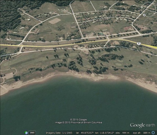
Fauquier as shown in Googel Earth
.
In recent days a large landslide has developed at the site, severely damaging some of the holes in the course. This news report describes the problem; there’s not much doubt that this is a landslide. There is a nice set of photographs of the landslide on the Daybreak South Facebook site, including these two:
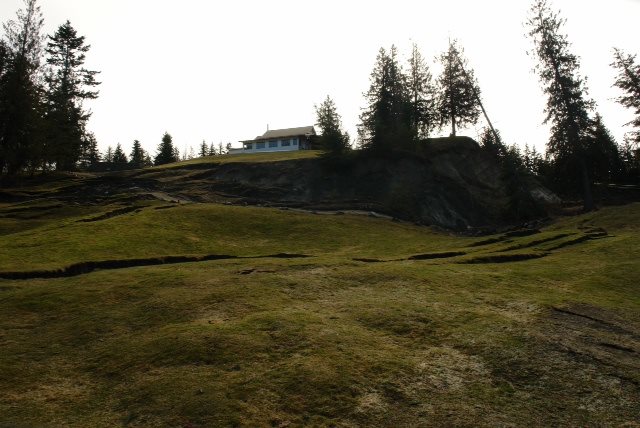
Fauquier Golf Course landslide via Daybreak South
.
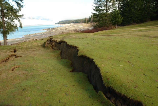
Fauquier Golf Course landslide via Daybreak South
.
.
The news reports suggest that the key opening time for the golf course at Faqquier is early April. Even if the movement has ceased getting the course playable by this time will be a challenge. The course appears to be an important source of revenue for the local community, so the effects of this landslide go far beyond the loss of a few rounds of golf.
19 February 2015
Paglajhora: another progressive road failure video
Paglajhora landslide video
There is an interesting video on Youtube from Paglajhora showing the collapse of a section of road:
.
Whilst this is not a new video (the accompanying text indicates that it occurred on 15th July 2010), I don’t think I’ve seen it before. The landslide apparently occurred at Paglajhora, on the Hill Cart Road connecting Siliguri and Kurseong in Darjeeling, northern India.
Paglajhora is described in a paper (Sarkar 2011) that is available online (NB PDF). This section of the Shiv Khola river is, according to Sarkar (2011):
“notorious for its slump/subsidence history that was initiated during the 1950 landslips in Darjeeling Hills…Since 1980, the incidences of slumping have become regular phenomenon, and by 1990 the Paglajhora slumps caused complete disruption of transportation and communication. The situation has deteriorated further in recent years”
The Paglajhora area is shown in the Google Earth image below; the yellow line is the Hill Cart Road:
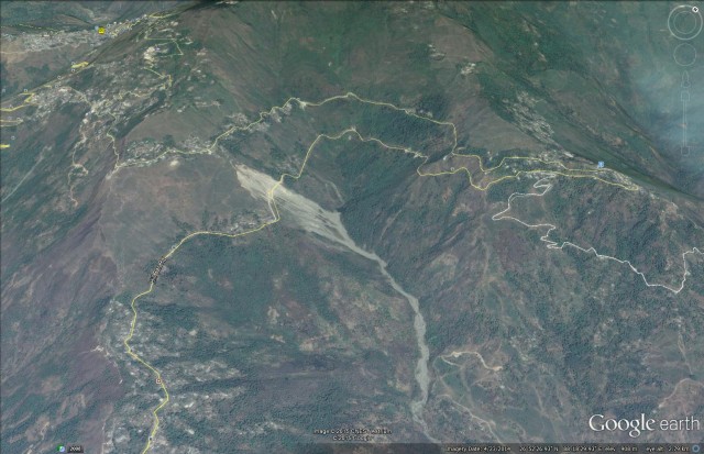
Google Earth perspective view of the Paglajhora area
.
The very extensive mass movement problem on this section of road is very clear, and indeed a closer view gives a better perspective on the serious nature of the problem at Paglajhora:
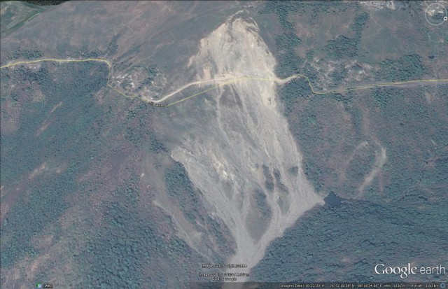
Google Earth perspective view of Paglajhora in 2014
.
Sarkar (2011) suggests that the landslide problem at Paglajhora is the result of very weak colluvial materials, the origin of which is attributed to much older and much larger landslides. The nature of these postulated landslides is intriguing and deserves further study. These deposits were then reactivated by low quality construction and maintenance of the road and railway line, with poor management of the slope continuing to play a major role in the problems. The image above, from April 2014, suggests that the problem is not going to get better soon without proper management, and indeed the inevitable retrogression of the crown of the landslide is going to threaten settlements upslope soon. Perhaps the most shocking aspect of this is a comparison with the Google Earth image from January 2003:
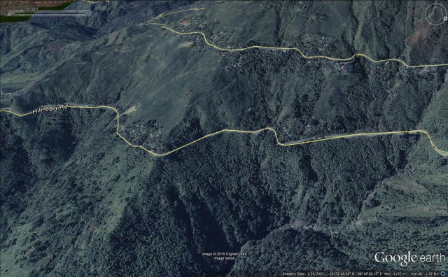
Google Earth perspective view of Paglajhora in 2003
.
The deterioration of the stability of the site in 12 years is remarkable. The morphology of the slopes in the 2003 image above would ring alarm bells to any competent geomorphologist or engineering geologist, and with good slope management it should have been possible to prevent this slope problem from developing. But, now that the instability has been initiated it will be extremely difficult, and expensive, to stop.
Reference
Sarkar, S. 2011. Evolution of the Paglajhora slump valley in the Shiv Khola Basin, the Darjeeling Himalaya, India. Geographia Polonica, 84 (2), 117-126.
18 February 2015
Landslides from the 2015 Wilberforce earthquake in New Zealand
Wilberforce earthquake
On 6 January 2015 a Mw=6.0 earthquake affected the Upper Wilberforce River catchment in South Island, New Zealand. Although this earthquake was not very large, its shallow depth (5 km) meant that the earthquake had the potential to generate landslides. On 8 and 9 January a team from GNS Science undertook a helicopter survey of the affected area to investigate whether landslides had indeed occurred. They have posted a brief report on the Landslides Reports part of the Geonet website.
The team mapped over 2000 individual landslides, the majority of which were situated in the area of greatest shaking:
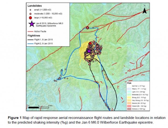
.
This is a naturally active landscape due to the combination of a dynamic climate and active tectonics. However, the earthquake clearly increased the level of landsliding, especially in the area that was affected by shaking of over 92 gals. The largest landslide had a volume that is estimated to have exceeded 140,000 cubic metres. In the report, there are several really good images of landslides triggered by the earthquake, of which I reproduce two here. This is a large and quite complex failure in the upper reaches of the Griffiths Stream:
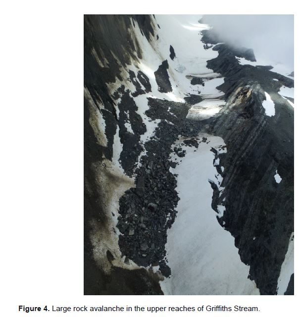
.
Perhaps the most interesting slide in the Wilberforce Earthquake occurred on the western side of the main divide on the Arahura River, which was briefly blocked. The landslide is estimated to have been about 25,000 square metres:
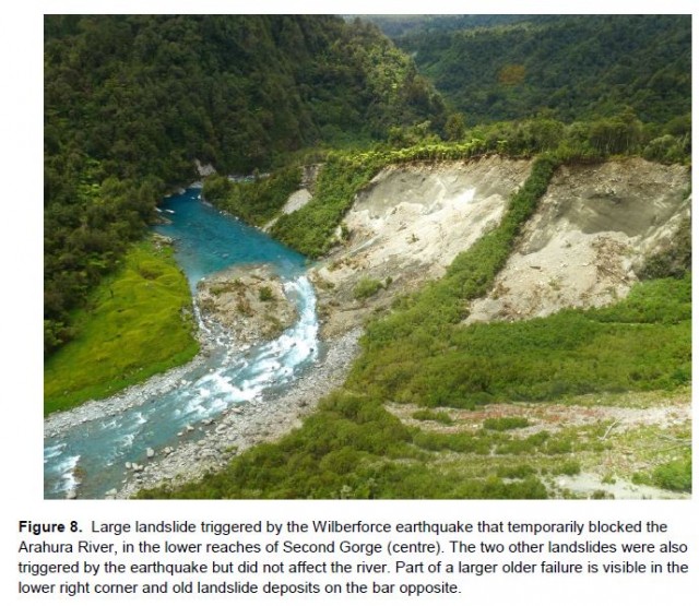
.
I am sure that the GNS Science team will now undertake a more detailed mapping and interpretation exercise for the landslides triggered by the Wilberforce Earthquake, and I shall look forward to seeing the results in due course. When analysed properly each of these events adds to our understanding of the controls on seismically-induced landslides, which require a great deal of further investigation.
15 February 2015
Fox Glacier – a time lapse video of slope failures as the glacier retreats
Fox Glacier
The spectacular Fox Glacier in New Zealand is a very popular tourist attraction on the South Island – Wikipedia estimates that around 1000 people visit per day. Sadly, the Fax Glacier is retreating rapidly, in common with most glaciers as they respond to the effects of climate change. And the effects are dramatic – this pair of images, taken ten years apart, shows just how quickly the glacier is retreating:
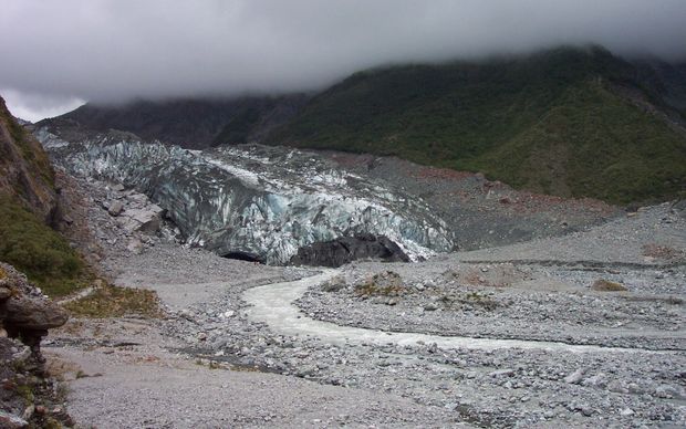
Fox Glacier in 2005: http://www.radionz.co.nz/news/national/264308/glacier-retreat-changes-valley
.
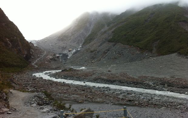
Fox Glacier in 2015: http://www.radionz.co.nz/news/national/264308/glacier-retreat-changes-valley
.
As the Fox Glacier retreats, the surrounding hillslopes, which consist of glacial till, lose toe support. In consequence they can slip, although this process is surprisingly poorly investigated. Kerry Leith of TU Munich, pointed out via Twitter this really interesting time lapse video of the glacier retreating, which captures beautifully the creep of the slopes as the snout of the glacier transitions through:
.
Fox Glacier’s spectacular retreat from Brian Anderson on Vimeo.
.
In the early part of the video the slopes on the right side of Fox Glacier are moving (comparatively) rapidly. By the end of the video the glacier has withdrawn from this section, and the slopes have stabilised. Thus, as the glacier snout moves up the valley a wave of slope movement moves with it. This process is being replicated worldwide as glaciers retreat in response to global warming.
The video was compiled by Victoria University of Wellington with the support of Fox Glacier Guides, Department of Conservation, Snowgrass Solutions, University of Canterbury and the Marsden Fund.
12 February 2015
Looking for a post-doctoral position? Come and work with me at the University of East Anglia
Landslides post-doctoral position at the University of East Anglia
I am currently looking to take on a post-doctoral researcher to work with me on landslides here at the University of East Anglia (UEA). This is a three year research post with the title of Senior Research Associate – Landslide Hazards and Impacts. The aim would be to work with me in particular on a number of projects, including:
- Developing and analysing the global landslide database;
- Contributing to the UEA component of the Earthquakes Without Frontiers research project, focusing in particular on seismically-induced landslides in Nepal;
- Contributing to our three year Newton Fund research project on seismically-induced landslides in Chile (joining a research team that includes the University of Chile, The University of Leeds and Durham University);
- Working with me on other research projects as and when they occur.
There will also be some opportunity to develop your own research ideas and publications.
.
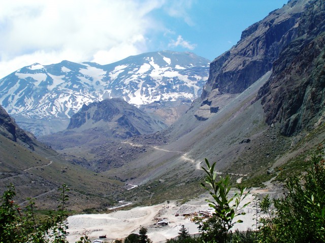
There are some impressive landslides in Chile
The successful candidate will also help me to maintain this blog, so if you want some social media experience then this would be a great opportunity. There may well be some opportunities to travel internationally.
The post is located in the wonderful School of Environmental Sciences at UEA in Norwich, in the East
Comments Off on Looking for a post-doctoral position? Come and work with me at the University of East Anglia
11 February 2015
Val Parghera:- A fascinating stop motion video of a large rockslide
Val Parghera
A very nice video has been posted on Youtube, showing a stop motion video of the movement of a large landslide in Val Parghera in Switzerland. This slide is being monitored as part of the Geopraevent programme on behalf of the Canton of Grisons. The video captures movements of the landslide between May 2013 and January 2015:
.
.
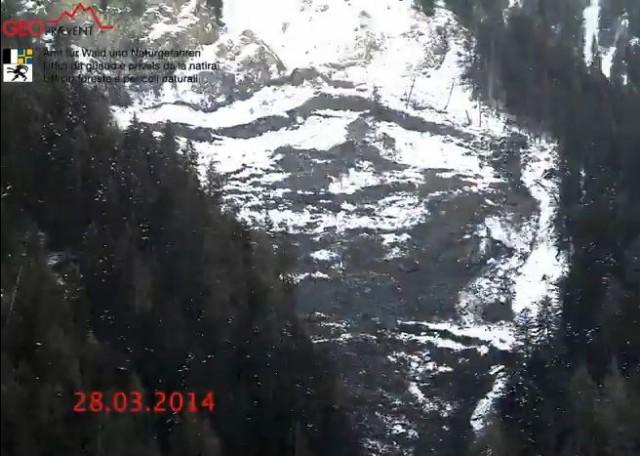
There is much of interest in this film, but I’ll just point out a few things. First, when viewed at this speed it becomes clear that the behaviour of the Val Parghera landslide is very much like a fluid flow, even to the extent of seeing higher velocities in the lower, narrow part of the landslide. Second, there is a very complex coupling between the main body of the landslide and this lower portion. At times it appears that the lower part slides first, removing the support for the main body of the landslide, whilst at others it seems that the main portion moves, loading the lower part of the slope. And third, the most impressive movement event occurs at the end of March 2014 – this is a screenshot of the failure developing:
.
I am sure that its no coincidence that this occurred at the end of the winter – one of the notable aspects is the thawing of the snow cover as the landslide movement event proceeds. According to Geopraevent, the movement event led to the closure of a local road, and a full monitoring system is now in place. It would be fascinating to do a full analysis of the movment patterns of this landslide along the lines of the work that we did on the Tessina landslide a decade (see Petley et al. 2005).
Reference
Petley, D. N., Mantovani, F. and Bulmer, M. H. K. and Zannoni, F. (2005) The use of surface monitoring data for the interpretation of landslide movement patterns, Geomorphology., 66 (1-4). pp. 133-147.
 Dave Petley is the Vice-Chancellor of the University of Hull in the United Kingdom. His blog provides commentary and analysis of landslide events occurring worldwide, including the landslides themselves, latest research, and conferences and meetings.
Recent Comments