
26 January 2021
Losses from landslides in Turkey
Posted by Dave Petley
Losses from landslides in Turkey
I’ve featured landslides of various types in Turkey over the years – the combination of topography, climate, tectonics and people in that country make it highly susceptibe to landslides. A new paper just published in the journal Landslides (Görüm and Fidan 2021) has analysed landslide losses in Turkey based upon a database of fatal events in the period 1929 to 2019. This is an important and valuable study, which greatly enhances and improves the global scale work that I’ve been undertaking for almost two decades.
The paper has attracted some attention in Turkey – for example there is an article in the newspaper Hurriyet Daily News that highlights the key findings. It notes that over the 90 year period of the study a total of 1,343 people were killed in 389 fatal landslides in the country, making landslides the second-most deadly hazard, after earthquakes. However, the study has also found that the average number of fatal landslides has increased substantially to 12.2 over the last two decades, increasing the average number of due to landslides to 23.6 per year. As usual this is probably driven mainly by the availability of better data for recent years, but there might also be an increase in losses as the population has increased and the environment has been degraded.
Perhaps the most interesting finding in the study is shown in the figure below, from Görüm and Fidan (2021):-
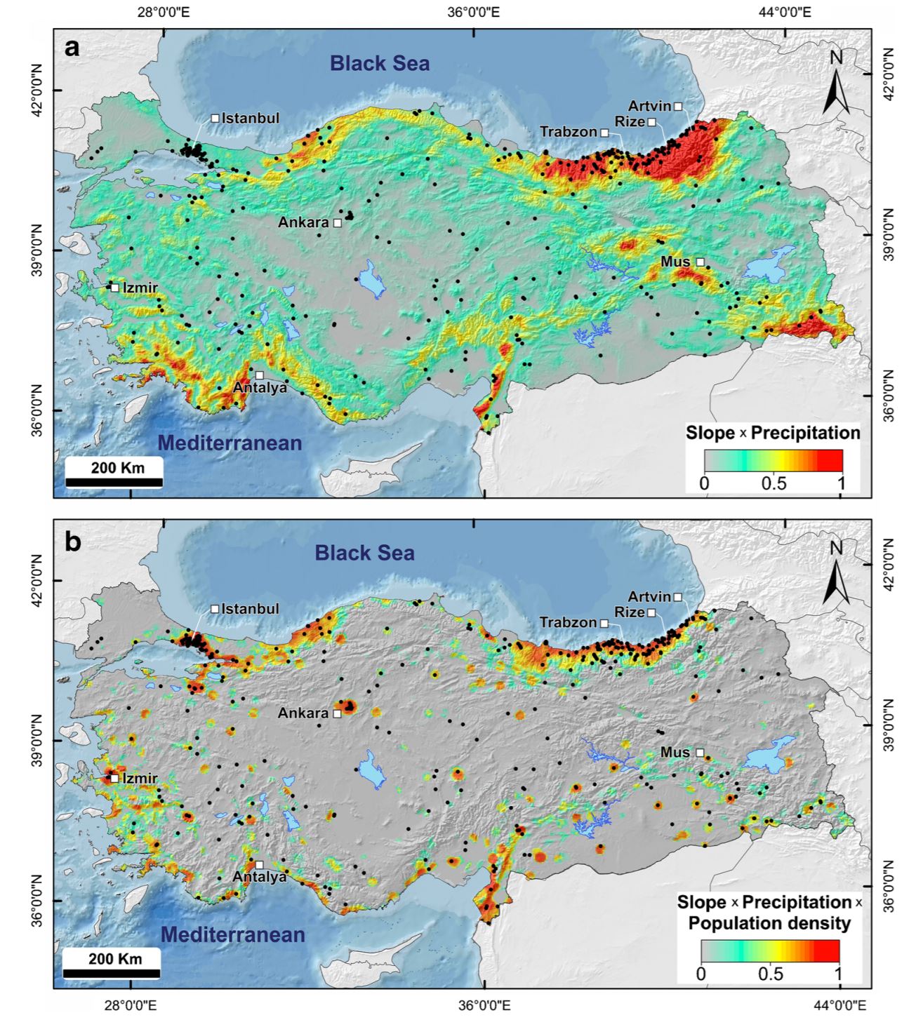
The natural and physical processes driving landslide losses in Turkey. The black dots are the fatal landslide events. The upper map is a combination of slope gradient and annual rainfall. The lower map is a combination of slope gradient, annual rainfall and population density. Diagram from Görüm and Fidan (2021).
.
The two maps show the fatal landslide events (black dots) underlain by a combination of average annual precipitation and slope gradient in the case of the upper panel. This explains the distribution of landslides quite well, although there are landslide clusters around the major urban areas for which the model cannot account. In the lower panel the population density is added to the algorithm. This combination does a good job of accounting for the spatial distribution of losses.
Of particular note is the hotspot of landslide susceptibility in the northeast of the country. As this area is densely populated, landslide losses here are high.
It is interesting that a number of studies have now shown that at the national or global level, the best spatial predictor of losses in fatal landslides is a simple combination of slope angle, annual precipitation and population density.
It is the aim of many of us working in landslide research to reduce loss of life in these events. Understanding the patterns in time and space is a key part of this; these national level studies are immensely valuable.
.
Reference
Görüm, T. and Fidan, S. 2021. Spatiotemporal variations of fatal landslides in Turkey. Landslides. https://doi.org/10.1007/s10346-020-01580-7
 Dave Petley is the Vice-Chancellor of the University of Hull in the United Kingdom. His blog provides commentary and analysis of landslide events occurring worldwide, including the landslides themselves, latest research, and conferences and meetings.
This is for quake-unrelated events ?
Must wonder if their big quakes are ‘shaking down’ a proportion of potential slides…
Whatever, ‘Be Not There’…
[Yes, it doesn’t include coseismic landslides. D.]
Very broadly speaking, seismicity will correlate with steepness, since many of the mountains in plate boundary zones like Turkey are raised along active faults. However, there are steep areas of Turkey that are not particularly earthquake prone which but are very landslide prone (like that far NE corner, near Trabzon).